Showing posts with label event recap. Show all posts

Thursday, April 6, 2023

Recap of the March 31, 2023 tornado outbreak in the Memphis area

A severe weather outbreak, producing multiple strong tornadoes from a small handful of supercell thunderstorms, affected the Memphis region on the evening of March 31-April 1. A total of 14 tornadoes touched down in the Memphis County Warning Area (CWA), which encompasses west TN, northeast AR, the Missouri bootheel, and north Mississippi. Three of these tornadoes were rated EF-3 and another five were EF-2. The graphic below summarizes their tracks.
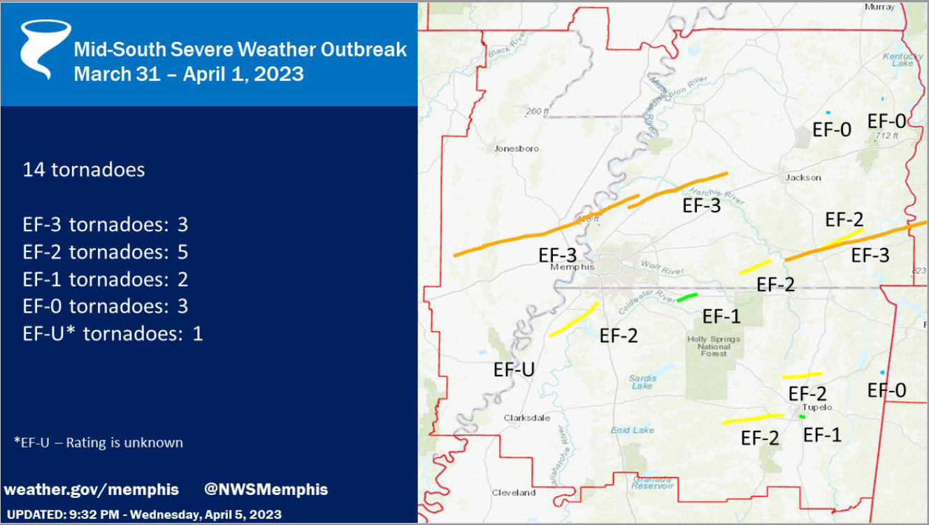

Within the eight-county Memphis metropolitan area covered by MemphisWeather.net (MWN), there were four tornado paths. Detail on each of these is summarized below. More detailed information from NWS-Memphis on all 14 tornadoes can be found here.  


Cross/Crittenden/Tipton County Tornado

Rating:                 EF-3
Est. Peak Wind:   150 mph
Path Length:        73.00 miles
Path Width (max):   1600 yards (0.91 miles)
Fatalities:             4
Injuries:               26
Start Time:           4:30pm
End Time:            5:54pm
Approx. Speed:    52 mph


Summary:
The "Wynne Tornado" touched down in western Cross County, AR at 4:30pm, spawned by the same supercell thunderstorm that resulted in tornado damage in North Little Rock earlier. The storm moved quickly east-northeast across Wynne with EF-3 strength, ravaging Wynne High School and destroying multiple residences. Slightly weaker, it passed north of Earle, AR (Crittenden Co) and crossed farmland before regaining EF-3 strength as it crossed Corna Lake in far western Tipton Co (west of the Mississippi River) before crossing the river and producing EF-2 damage in Wilder Farms (Tipton Co), eventually lifting near Burlison.


Tipton/Haywood County Tornado

Rating:                 EF-3
Est. Peak Wind:   150 mph
Path Length:        39.53 miles
Path Width (max):   2000 yards (1.14 miles)
Fatalities:             1
Injuries:               28
Start Time:           5:48pm
End Time:            6:29pm
Approx. Speed:   58 mph


Summary:
The "Covington Tornado" originated from the same supercell thunderstorm as the Wynne tornado, and touched down six minutes before the Wynne tornado lifted, meaning the supercell produced twin tornadoes for that six-minute period over Tipton Co. This tornado touched down at 5:48pm just northwest of Munford and moved quickly northeast while increasing in strength as it approached Highway 51 south of Covington. Several homes and businesses were completely destroyed and many more were significantly damaged. Fifty-three power poles had to be replaced along Highway 51 south of Covington. The elementary and middle schools sustained heavy damage, as did additional homes along Highway 54. A couple of large metal power poles were bent to the ground as the tornado widened to a mile in width as it moved across rural area east of Covington. It continued east-northeast across farmland and Hatchie River wetland before weakening and eventually lifting north of Brownsville in Haywood Co. 


Tunica/DeSoto County Tornado

Rating:                 EF-2
Est. Peak Wind:   130 mph
Path Length:        22.87 miles
Path Width (max):   1200 yards (0.68 miles)
Fatalities:             0
Injuries:               0
Start Time:           7:31pm
End Time:            8:02pm
Approx. Speed:   47 mph


Summary:
The "Prichard-Nesbit Tornado" touched down just northeast of the Tunica airport, moving northeast, mainly through rural areas of Tunica and DeSoto Co. Snapped and uprooted trees were observed in Tunica and southwest Desoto county.  Roof damage occurred after passing thru the Arkabutla bottom, with extensive tree damage and damaged or destroyed homes noted west of Highway 301.  Between Baldwin & Fogg Rd there was EF-2 damage and the tornado dissipated southwest of Nesbit.


Marshall County Tornado

Rating:                 EF-1
Est. Peak Wind:   95 mph
Path Length:        8.13 miles
Path Width (max):  100 yards
Fatalities:             0
Injuries:               0
Start Time:           8:27 pm
End Time:            8:37 pm
Approx. Speed:   50 mph


Summary:
An EF-1 tornado touched down in Marshall county west of Highway 311, moving northeast before dissipating about ten minutes later northeast of Slayden. Primary damage was to hardwood trees that were snapped or uprooted, while one home also sustained roof damage.

Shelby County Damaging Wind

Finally, MWN surveyed the Sea Isle area of southeast Memphis, near I-240 and Mt. Moriah Road leading into the area of Quince and Estate, as well as American Way between Getwell and Mt. Moriah Roads. Over this large area, many mature hardwood trees were uprooted or had large branches snapped by strong wind. Trees were observed to have fallen on houses, vehicles, and power lines/poles, resulting in additional damage and thousands of customers without power. Near American Way and Getwell, a high-voltage transmission tower was bent over (though a photo of the tower prior to the storm suggested that it may have had preexisting damage that had weakened the structure). In addition, there were three fatalities, including two children, due to a tree falling on their home on South Edgewater Road in the area of Memphis International Airport.

Given the scattered nature of the damage and no "ground path" observed, the damage was due to straight-line wind on the edge of a strong supercell that moved by just to the east of this area into Germantown. The National Weather Service and NEXRAD radar corroborates that this damage was caused by up to 85 mph wind generated by the "forward flank downdraft" of the supercell.

Erik Proseus
MWN Meteorologist

----
Follow MWN on Facebook and Twitter for routine updates and the latest info!
Complete MWN Forecast: MemphisWeather.net on the mobile web or via the MWN mobile app
Download our iPhone or Android apps, featuring StormWatch+ severe weather alerts!
MWN is a NOAA Weather Ready Nation Ambassador Meteorologist Erik Proseus is an NWA Digital Seal Holder

Sunday, February 6, 2022

Ice Storm 2022 recap, a quiet week ahead, and "adieu" to an intern

Recap of Ice Storm 2022

Wow, what a storm! Unfortunately, the forecasts leading up to Thursday's ice storm proved to be fairly accurate. Nearly 2" of liquid fell from the sky and much of that occurred with temperatures at or below 32 degrees, making it "freezing rain." Forecast details included that much of it would run off and not freeze due to the intensity of the precipitation, and that streets in general would not be too bad due to temperatures staying very close to freezing. The forecast also predicted 0.25-0.50" of ice on exposed objects such as trees and power lines. All of that proved to be accurate and most sources seemed to be in unison on the forecast and potential impacts.
Those impacts, though, were far-reaching: tree branches falling, trees uprooted, power lines thickly coated, slick overpasses and bridges, and power outages to hundreds of thousands of utility customers.  Memphis Light Gas and Water (MLGW) reported that 272,000 customers were affected at one point or another, which is nearly 2/3 of their customer base. 

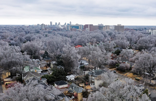
The Medical District and Downtown Memphis skyline surrounded by ice-covered trees following an ice storm on February 3, 2022. Photo used with permission. (Patrick Lantrip/Daily Memphian)

As of Sunday afternoon, that number is down to about 80,000, or 20% of their customers in Shelby County. The hope is to have another 10% (or about 40,000 more) restored by midnight Monday night and everyone restored by the end of the week. There are currently 1,000 MLGW or contract lineman and tree trimmers working on restoration. This storm now ranks as the second worst in the utility's history, behind "Hurricane Elvis" in 2003 (340,000 customers out) and ahead of the benchmark for ice storms in the area: the infamous 1994 storm, in which about 250,000 customers lost power. In that storm, it took two weeks to fully restore the city.

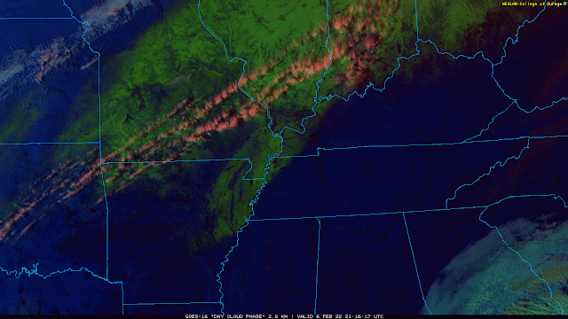
Late Sunday afternoon satellite imagery using the "Day Cloud Phase" product shows lingering snow and sleet in bright green. Notice there is none over the Memphis area and most of west TN, as glaze ice like we received doesn't show up on this channel. and most had also melted. (College of DuPage)

Click here for a gallery of photos from The Daily Memphian, or check out our Twitter feed for photos!

Turning our sights to the future though, I hand the keyboard over to MWN intern Dylan Hudler...

This week's forecast

Phew! After the ice storm, we need a break from active weather. Well, we’re in luck because that’s exactly what Mother Nature has in store for us.

This coming week will feature fairly calm weather thanks to high pressure. We’ll experience three frontal passages - all "dry," meaning they won’t bring any rain or storms. That’s about all the "action" we’ll see in the near term.


Monday may start off foggy for some of us, especially from Memphis into the Mississippi Delta. Ice melt today has left a lot of moisture in the region. Calm winds and a couple of other factors may lead to some patchy fog tomorrow morning. Otherwise, we’ll warm to near 46 in the afternoon under partly cloudy skies.

Tuesday looks to be warmer and breezier as winds shift out of the southwest. Winds may gust 15-20 mph.

Wednesday and Thursday both will feature sunshine and afternoon high temperatures in the mid 50s.

Friday will be even warmer, with a high near 60! Southwest winds will help to bring warm air and moisture into the region ahead of an approaching front. It’s possible we see some isolated light showers Friday evening associated with that front, but there’s uncertainty with it being five days away. For now, we’ll keep rain chances at 10%.

Next weekend brings a mix of sun and clouds, with highs likely in the 40s and lows near 30.

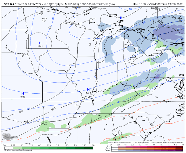
The American GFS model valid on Saturday night shows low precipitation chances to our south associated with a frontal passage earlier in the day locally. Another large, cold high pressure system centered over the Midwest brings us cooler weather for the weekend. (WeatherBell)

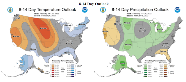
Looking ahead to the week of the 14th, the NOAA Climate Prediction Center expects near normal temperatures and perhaps slightly above average precipitation according to the outlooks shown below. 

NOAA CPC temperature and precipitation outlook for February 14-20.

Parting thoughts

Lastly, as some of you may know, I have accepted a job offer from WCBI-TV in Columbus, MS to be their newest meteorologist. This will be my last time logging on for MWN. I am excited to start my new job, but sad to leave my family here at MWN. I would like to say thank you to Erik and the rest of my MWN team because without them, I wouldn’t be where I am today. I am so thankful for my time forecasting and covering the weather for this amazing community. I’ve loved every minute of it! So, with that being said, this is MemphisWeather.net Intern Dylan Hudler “/DH” signing off. Thank you all!

Intern swap

[Back to Erik... ]
Dylan has been an awesome addition to #TeamMWN and I am so grateful for his service to us and all of you! He has an amazing future ahead of him and I look forward to one day seeing him on the green screen in a large market in his home state of North Carolina. 

Dylan is being replaced by another bright young man with a ton of potential. Jacob Woods hails from the Mayfield, KY area (yes, the Mayfield that was hit hard by a tornado on December 10) and will be on "the MWN tweeter" in about a week! I look forward to his unique perspective having recently been through a major event.  

We wish you nothing but the best in your future endeavors, Dylan!


Erik Proseus & Dylan Hudler
MWN Meteorologist / MWN Social Media Intern

----
Follow MWN on Facebook and Twitter for routine updates and the latest info!
Complete MWN Forecast: MemphisWeather.net on the mobile web or via the MWN mobile app
Download our iPhone or Android apps, featuring StormWatch+ severe weather alerts!
MWN is a NOAA Weather Ready Nation Ambassador Meteorologist Erik Proseus is an NWA Digital Seal Holder

Sunday, January 16, 2022

Wrapping up the January 16, 2022 snow event

Well, that was fun! 

That is one way to describe about 3 days on non-stop hand-wringing over one of the most challenging winter weather forecasts this meteorologist has encountered in 25 years of forecasting the Memphis area. Friday's blog described the scenario - one in which a rare atmospheric setup resulted in an upper level low taking a giant hook over the southern Plains towards the area and merging with surface low pressure over the Deep South. Even our most reliable medium-range global models and short-term high-resolution models struggled with consistency and output, with wild swings in potential snow amounts for the area. Add in the potential for "banding" of snow in small areas due to the power of the upper low, and you end up with a very challenging event.

In the end, on Friday I decided on rain changing to snow near or after midnight, potential heavy in the early morning hours, tapering in the hours after sunrise, and "generally 1-4 inches with the greatest probability of the higher amounts east of Memphis." I also said in the blog "localized bands could produce up to 4-6" of snow." And with a little bit of luck, that verified pretty well if I do say so myself. 

How it started: How it ended:
 
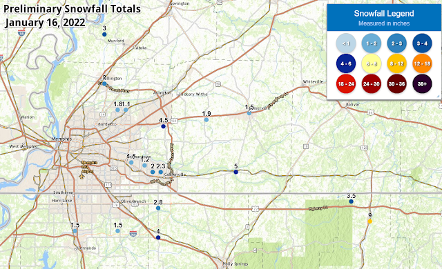
A preliminary listing of snowfall totals from across the Mid-South can be found here.

Overall, 1-2" is what the immediate metro received with lower amounts closer to the river and higher amounts in eastern rural areas. Going further east, areas near the TN/MS state line east of the metro saw isolated amounts of up to 5-9"! The amounts in the city were slightly reduced by the "wetness" of the snow that fell. Typically, snow in the Mid-South has about an 8:1 to 10:1 snow ratio, meaning that for each 0.10" of liquid water that falls, about 3/4"-1" of snow can be expected. Because temperatures were just above freezing, relative humidity was above 90% and the amount of moisture above us was high, the snow ratio for this system ended up being closer to 5:1. That reduces potential snow totals by up to one-half of what would fall with snow that isn't so wet. We knew it would be a wet snow, but not quite THAT wet! 

In addition we also saw that where snow came down hard (like in the video above where snow-globs were more than an inch in diameter as they fell), even with temperatures above freezing, the roads can coat pretty quickly. The fact that temperatures didn't get below freezing by much, or for long, meant that they also melted fairly quickly once the sun rose and snow ended.

There were scattered power outages in the Memphis area and, tragically, one woman lost her life while driving a vehicle when a snow and ice laden tree fell over and landed on her car in southeast Memphis. But overall, it ended up being a manageable event for most.

Hopefully you were pleased with what you ended up getting today! Given the MLK Day holiday tomorrow, I expect no issues at all when work and school start back on Tuesday. If you are out early tomorrow though, you will want to keep an eye out for a little black ice in spots where melting occurred and left water on the roads tonight. Hopefully we don't have any more of those types of events again for a long while!actio

Erik Proseus
MWN Meteorologist

----
Follow MWN on Facebook and Twitter for routine updates and the latest info!
Complete MWN Forecast: MemphisWeather.net on the mobile web or via the MWN mobile app
Download our iPhone or Android apps, featuring StormWatch+ severe weather alerts!
MWN is a NOAA Weather Ready Nation Ambassador Meteorologist Erik Proseus is an NWA Digital Seal Holder

Saturday, December 11, 2021

Recapping Friday night's storms, plus a moment of gratitude

Decided it would be appropriate, maybe cathartic, to sit down a put a few thoughts on electronic paper after last night's severe weather outbreak. 

First, a bit of a recap. The Memphis metro was very fortunate! Monette Manor nursing home, which was devastated by the tornado that ended up traveling over 250 miles through AR, MO, TN, and KY, is 55 miles from downtown Memphis and just 35 miles from western Tipton County.. 
That tornado would go on to destroy the town of Mayfield, KY, over 110 miles away.
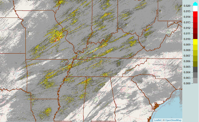
Looking at NEXRAD Doppler radar estimates of rotation, that tornado (or at least its parent storm, possibly producing multiple tornadoes) traveled over 250 miles in a few hours. If determined to be a singular tornado, it would set the record for the longest path length in recorded history. You can easily pick it out in the image of rotation tracks from last night:

MRMS radar data showing where rotation was observed Friday evening into the night. Higher values mean stronger rotation. (MRMS via the NWS)

But if you look at that image more closely, you'll see how many areas had rotating storms pass overhead. Not all produced tornadoes, but the parent supercells were rotating aloft. There is even some rotation in the metro, particularly along and south of I-40, though more sporadic than the long-tracked events to our north. Locally, two Tornado Warnings were issued for Shelby County. One was for storm circulation that developed over West Memphis and moved into Shelby Forest towards Millington before dissipating. A second right behind it had a stronger rotation signature near the Fairgrounds and moved across the Sam Cooper area and basically along I-40/Highway 70 into northwest Fayette Co. A spotter report of a funnel cloud or brief tornado touchdown was received near the Airline Road exit at I-40 heading into Fayette Co, but so far no damage reports have been received that we are aware of.
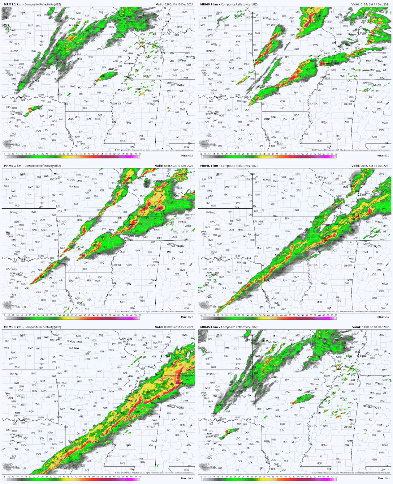
If you want to re-live the entire event, here are a few recap images. First, a radar loop of the entire night, from 5pm Friday to 5am Saturday.

Radar loop for the Mid-South from 5pm Friday to 5am Saturday (MRMS via WeatherBell)

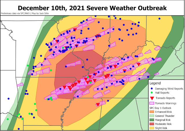
Here's a recap of the event from the perspective of the National Weather Service, showing their  midday Friday severe weather outlook (when the Level 4 Moderate Risk was issued), preliminary severe weather reports, and Tornado Warnings issued. Honestly, it's hard to get a whole lot better than that from the perspective of the Storm Prediction Center, who issues these outlooks. They are the severe weather experts and are exceptional, particularly on the big events. We had known something was brewing as early as Monday.

Summary of NWS severe weather outlook and tornado warnings issued, with storm reports overlaid. Graphic credit: Jack Sillin

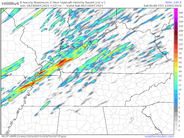
By the way, the high-resolution computer modeling that we use to help pinpoint timing and location of threats on the day of an event did an overall remarkable job. These advances in science are saving lives by giving people like us good information to relay to you. Check out the forecast below from the HRRR, our best short-term forecast model. It is a forecast from noon yesterday showing where supercell rotation and possible tornadic activity would occur between 6pm and midnight. It basically nailed the exact path of the long-track storm that produced tornado damage from Monette to Mayfield and beyond. Simply astonishing.

The 18Z (noon Friday) HRRR model forecast showing where it believes rotating storms will occur. This image is for the period between 6pm and midnight Friday. (WeatherModels)


A personal moment of reflection and gratitude

So, while we were very fortunate, there are others that are less so this morning. Our hearts ache for those places where destruction occurred, where lives were turned upside down in a matter of minutes. 

For the elderly folks in a nursing home in Monette literally having the roof lifted from above their heads and debris raining down, and losing a fellow resident and friend in the process. 

For the town of Mayfield that was nearly, literally, wiped off the map. 

Bowling Green - where a Western Kentucky University student lost a relative the day before walking the stage to receive a degree. 

Amazon workers near St. Louis - who witnessed the walls and roof come crumbling down under the stress of high wind.

And many others that won't make the national news, but are hurting just the same.

Amongst the destruction though, there are heroes. The headlines and news stories will laud the first responders and the doctors and nurses, all of whom indeed deserve every bit of praise for their heroic acts. They rush towards the destruction, or into medical facilities, all to serve others. And many of them are also personally affected because the storms hit the communities they serve and affect people they know directly.

But there are those who get less credit - who aren't the first ones called out by governors and mayors for their heroism and aren't named in news stories. 

They are the scientists that make the jobs of those first responders less burdensome. They save lives simply through public awareness, directly resulting in fewer that need emergency assistance. They are the men and women who build the weather models, that issue the severe weather outlooks days in advance to raise awareness, that issue and communicate the forecasts locally, and then sound the alarm with severe weather warnings to prompt action to be taken by the public. The meteorologists who live in the communities they serve, and have family members at home taking cover while they go above and beyond to serve, and also heroes - on days like yesterday, and every day. 

So today, I want to thank my colleagues in research, operations, and broadcast among other sectors, for their dedication to public service. They are underappreciated, and particularly after a night like last night, deserve our collective gratitude.

Erik Proseus
MWN Meteorologist

----
Follow MWN on Facebook and Twitter for routine updates and the latest info!
Complete MWN Forecast: MemphisWeather.net on the mobile web or via the MWN mobile app
Download our iPhone or Android apps, featuring StormWatch+ severe weather alerts!
MWN is a NOAA Weather Ready Nation Ambassador Meteorologist Erik Proseus is an NWA Digital Seal Holder

Saturday, July 10, 2021

Pattern shift brings highest rain chances in a month

Prior to yesterday's deluge (for some of you), the previous month has been abnormally dry. We started June with very wet weather, particularly south of I-40 and into north MS, but once it dried out, it did so for all of us. 

Below, images show the rainfall departures from normal for June 10-July 9 and Thursday's Drought Monitor for Tennessee. For the past 30 days, the metro had accumulated a deficit of 2-3" of rain, or roughly only 30-40% than normal. Parts of Shelby and Tipton Counties were officially classified in D0 status, or "abnormally dry." My lawn has needed water weekly for the past few weeks now to keep it from browning up.

Rainfall departure from normal for June 10-July 9. Precipitation deficits of 2-3" (or 60-70%) were observed in the metro. (HRAP Precip Analysis via WeatherBell)

The Drought Monitor on July 8 shows "abnormally dry" conditions in portions of Tipton and Shelby Counties.

That atmospheric pattern started to change yesterday though, and the new pattern will continue into the middle of next week, as an upper level low pressure system forms to our north.

Friday retroactively rated "outperform"

Before we look into the weekend ahead, Friday's event was definitely interesting, and admittedly not well-forecast. The setup was basically a remnant outflow, or surface, boundary that moved into the metro Thursday night. You may recall a narrow line of storms making it to northern Tipton County Thursday evening. Many of us north of I-40 had a pretty decent light show after dark from distant lightning (not heat lightning!). 

As those storms fizzled, the boundary slipped south to around the TN/MS state line. Our best computer models really didn't pick up on much activity along that boundary early Friday, other than maybe a few isolated showers. I honestly didn't expect much. (In fact, I left my passenger side car window cracked a couple of inches when I went to work by the airport Friday morning!) Well, "outperform" would have been the proper rating if this were the stock market. 


With moist air flowing up from the southwest over the boundary and very muggy and unstable air in place by mid-morning, storms fired up and moved east-southeast along the boundary draped along the state line, while continuously regenerating back to the west along I-40 in east AR. Over and over, storms trained along the boundary from southern Crittenden Co along the Shelby/DeSoto border, into northern Marshall County, a "state line special." By noon, 4-6" of rain had fallen in that corridor, a couple of inches fell at the airport (some into my front passenger seat!) - setting a daily rainfall record, and most of the rest of the metro was wondering what all the fuss was about! My home in Bartlett received exactly zero drops. 

Below is the radar estimation of rainfall totals for the day, including scattered storms that formed in the afternoon in northeast AR and made it into northwest portions of the metro and lingering light rain for Shelby County in the evening. It was quite a day!

Radar estimation of rainfall for Friday's localized deluge (MRMS data via NSSL)

This weekend - northwest flow

For those who still haven't gotten their "fair share" of rain, all hope is not lost. Yesterday was a prelude to a transition in which the upper air pattern becomes northwesterly, allowing storm systems from the north to move into the Mid-South - commonly called northwest flow. It is not unusual to see this pattern a couple of times each summer and it is also a difficult one to forecast details more than about 24 hours out. The northwest flow will be driven by the development of low pressure in the mid levels of the atmosphere over the Upper Midwest that drops into the Missouri over the next few days, before weakening and lifting northeast by about Tuesday night.

The mid-level (500mb or 18,000') flow pattern from Saturday morning through Tuesday evening features a developing low pressure center over the Missouri River valley, resulting in "northwest flow" for our area tonight into Sunday, then a trough over Arkansas to start the week. (Euro model via WeatherBell)


Today starts mainly dry as we haven't quite transitioned from a high pressure/summertime setup just yet. A few afternoon showers or thunderstorms are possible in the heat of the day as temperatures reach 90 degrees, but short-term high-res models disagree on the extent and intensity of any pop-ups. Don't be surprised by some thunder and localized downpours - remember to evacuate the pool if thunder and lightning are nearby!

As we head into tonight, the first of the "northwest flow" system moves in. This one seems to be fairly well predicted by the morning model data. A line of storms is likely to drop through Missouri this afternoon and into northern AR and northwest TN this evening. That line appears likely to reach the metro around midnight, or perhaps a bit before, midnight. 

The 7am model runs of the HRRR (left) and NAM3 (right) show what they think radar will look like at midnight tonight. Subsequent iterations of the HRRR, which runs hourly, are a touch earlier with storms. Prepare for strong wind and heavy rain late this evening. (WeatherBell)

We are outlooked in a Marginal to Slight Risk of severe weather (level 1-2), with the primary threat being strong wind gusts with the line. The threat appears to be highest to our north, and the line may be weakening a bit as it gets here. Sometimes these things don't go according to plan though. The tornado and hail risk is very low, but the heavy rain threat is high as showers continue overnight after the main line. Stay tuned throughout the day and evening for updates, and prepare for the possibility of scattered power outages and minor wind damage overnight, especially in northeast AR and west TN. You'll want to have multiple methods of receiving warning information, just in case!


By Sunday morning, lingering showers will likely be falling apart, but a muggy airmass is likely to recover (or become more unstable) by afternoon and scattered showers and thunderstorms are again expected. These could last well into the evening. Though it will be cooler (mid 80s for highs), it'll still be muggy with southwest wind becoming gusty at times and a bit of sun peeking through during the afternoon as well. I expect all of us will have received some decent rain by Sunday night. In fact, the NWS has outlooked parts of the area, mainly south of I-40, in a Slight Risk (level 2) of excessive rainfall (not severe storms) for Sunday.


Starting the work week with continued rain chances

As the upper level low spins over Missouri, more showers and thunderstorms are likely on Monday. These may be more diurnally driven, meaning they are most likely during the warmest hours of the day. Keep that in mind as you make your plans for Monday. Many of us could get more rain and a few storms, most likely below severe limits, on Monday as highs remain in the mid 80s.

Tuesday will see rain chances drop off some as the low starts to weaken to our north, however scattered showers and thunderstorms appear to be a good bet in the afternoon and evening hours. Look for temperatures to start to recover and humidity to remain high. High temps will be in the upper 80s.


The latter half of next week appears to be more typical of summer (and much like this past week) as high pressure builds back in. High temperatures in the lower 90s and lows in the mid 70s will be common with isolated to widely scattered storms Wednesday-Friday.

Erik Proseus
MWN Meteorologist

----
Follow MWN on Facebook and Twitter for routine updates and the latest info!
Complete MWN Forecast: MemphisWeather.net on the mobile web or via the MWN mobile app
Download our iPhone or Android apps, featuring StormWatch+ severe weather alerts!
MWN is a NOAA Weather Ready Nation Ambassador Meteorologist Erik Proseus is an NWA Digital Seal Holder

Saturday, February 20, 2021

Temperatures and snowfall records set during the recent Arctic Outbreak

Now that we are back above freezing (at least during the day) and the #StupidCold Arctic Outbreak is receding, we can look back and see, statistically, just how cold and snowy it was. The following temperature and snowfall records are now in the books:
  • Coldest high temperature: February 14 (19°)
  • Coldest low temperature: February 15 (9°)
  • Coldest high temperature: February 15 (15°)
  • Coldest low temperatures: February 16 (1°)
  • Tied coldest high temperature: February 16 (18°)
  • Coldest low temperature: February 20 (9°)
  • Daily record snowfall: February 15 (4.0")
  • Daily record snowfall: February 17 (4.7")
  • Fourth snowiest four-day period: February 14-17 (10.0")
  • Tied for second - consecutive days with high temperatures less than 20° (February 14-16)
  • Tied for longest consecutive streak of days with high temperatures less than 32° (February 11-19)
  • The average temperature for the period February 11-19 was 19.8° - the coldest for that nine day stretch on record.
All data is recorded at Memphis International Airport, the official observation site for Memphis, TN.

Estimated snowfall over the past week. Graphic courtesy NWS-Memphis.

Average temperature anomaly (departure from normal) for the week of February 12-19, 2021. Data provided by the NOAA/NCEP Climate Data Assimilation System (CDAS). And yes, the cold across the central portion of the country appears to be "off the charts!" (WxBell)


Erik Proseus
MWN Meteorologist

----
Follow MWN on Facebook and Twitter for routine updates and the latest info!
Complete MWN Forecast: MemphisWeather.net on the mobile web or via the MWN mobile app
Download our iPhone or Android apps, featuring StormWatch+ severe weather alerts!
MWN is a NOAA Weather Ready Nation Ambassador Meteorologist Erik Proseus is an NWA Digital Seal Holder

Tuesday, April 14, 2020

Cold weather moderates this week as rain chances increase this weekend

We experienced a wide variety of weather over the past week! Daily high temperatures varied from the low 80s to the upper 50s. We did see quite a bit of rain Sunday, from multiple rounds of rain and storms, particularly a lengthy period of heavy rain during the late morning and early afternoon hours. The total rain received on Sunday was 2.60". It didn't break the daily record, but the amount was well above average.

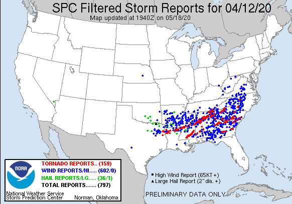
Thankfully we missed the worst of the storms as parts of Louisiana, Mississippi, Alabama, southeast Tennessee, Georgia, and North Carolina saw all types of severe weather. There have been a total of 651 storm reports received by the NWS. There was a truly devastating tornado in Southern Mississippi with the worst of the damage being in Bassfield, MS. This tornado has been given a preliminary rating of an EF-4 with maximum wind gusts of 170 mph! If you would like to look at the damage it caused, here is a link to drone footage.


200412_rpts Filtered Reports Graphic
These are the filtered storm reports from the SPC from 4/12/2020.
Image
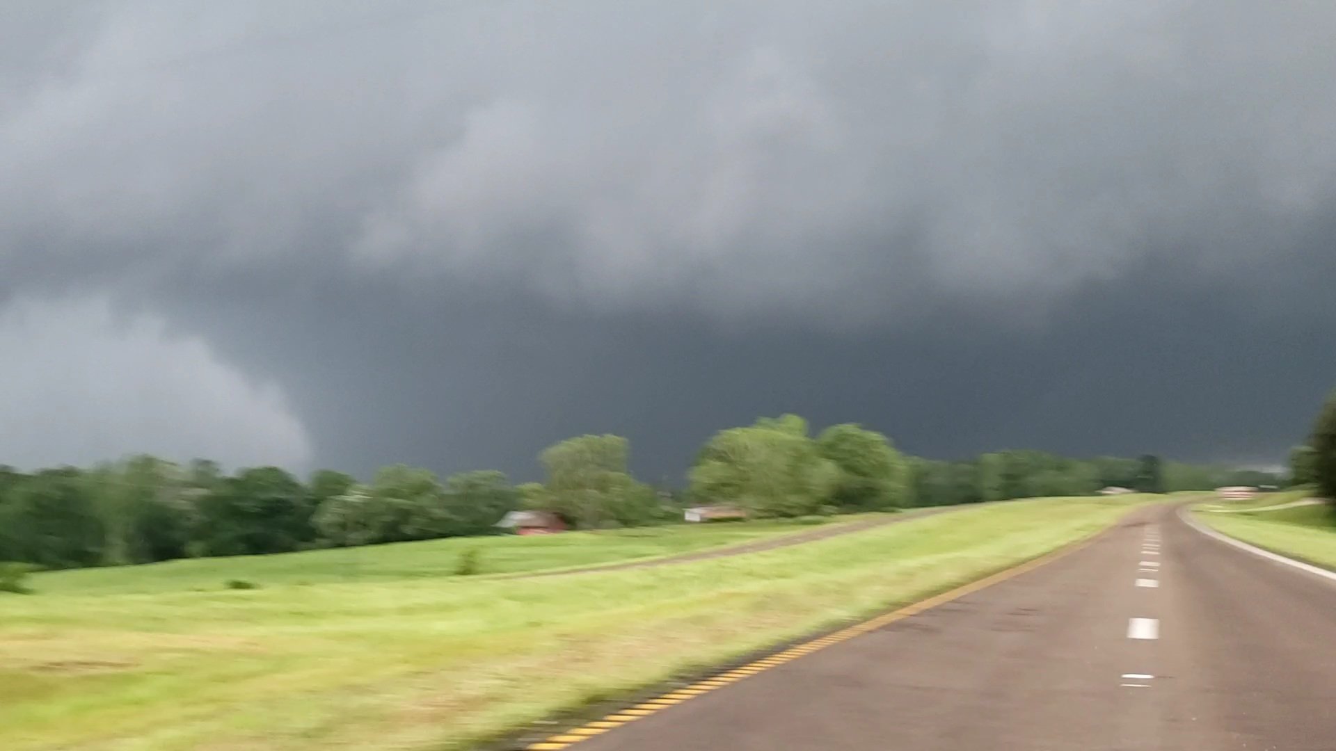
This is the tornado near Soso, MS (in southern MS). Photo credit: Connor McCrorey (@ConnorWX). This is a direct link to the tweet: https://twitter.com/ConnorWX/status/1249456589712633858.
Tuesday Night
The clouds will move out making for a clear and cold night. Much of the Memphis metro is under a Frost Advisory as temperatures are expected to drop into the mid 30s. A Freeze Warning is in effect for Tipton and Fayette Counties, as those areas have the highest probability of temperatures dropping as  low as 30 degrees. Bring in those tender plants or cover them up!


Wednesday
After a very cold early morning, we should be in store for a pleasant Wednesday. Temperatures are expected to rise to the low 60s with sunny skies. Winds during the day should be from the southwest at about 7 mph. Wednesday night into Thursday temperatures are expected to drop to around 40 under a clear sky. Some patchy frost is possible in rural areas.


The GFS model shows why temperatures are so cold right now. Anomalously low pressure aloft over much of the nation means cold polar air is in place at that level. Those blues, purples, and greens are showing that the pressure at 500mb (18,000') is much lower then normal. (WxBell)

Thursday and Friday

Thursday temperatures will top out around 70 under sunny skies. The breeze will be out of the south at about 10 mph. Overnight temperatures will drop to the upper 40s as some cloud cover moves in. On Friday, conditions should be partly sunny with temps in the lower 70s. There is also a slight chance of rain, but it shouldn't cause any real issues. Friday night temperatures will drop into the upper 40s with a slightly better chance of a rain shower.

Saturday and Sunday

Saturday temps will top out in the upper 60s under partly sunny skies. There also still a chance for a lingering shower. Saturday night the chance of rain will increase with scattered showers possible. Sunday will be pretty similar to Saturday. Sunday temperatures will top out around 70 under mostly cloudy skies. There is a continued chance of showers, though no washouts are currently forecast for the weekend. Sunday night lows will drop to around 50 with clouds clearing a little, making for a partly cloudy night.

Monday and Tuesday

The warming trend continues with Monday's highs in the low 70s under partly cloudy skies. Overnight temperatures will drop to the lower 50s. Tuesday temperature will top out in the mid 70s under partly sunny skies.

A Look at Next Week
Using the projections from the Climate Prediction Center (CPC) it looks like temperatures will probably be near normal and precipitation will probably slightly above normal. We'll be watching the mid-week period for our next round of storms.

Latest 6 to 10 Day Temperature Outlook
These are the probabilistic chances of temperatures being above or below normal across the United States (CPC).
Latest 6 to 10 Day Precipitation Outlook
These are the probabilistic chances of precipitation being above or below normal across the United States (CPC).

Max Magness
MWN Meteorologist Intern

----
Follow MWN on Facebook and Twitter for routine updates and the latest info!
Complete MWN Forecast: MemphisWeather.net on the mobile web or via the MWN mobile app
Download our iPhone or Android apps, featuring StormWatch+ severe weather alerts!
MWN is a NOAA Weather Ready Nation Ambassador Meteorologist Erik Proseus is an NWA Digital Seal Holder

Tuesday, December 31, 2019

Reviewing the past decade at MemphisWeather.net

As we come to the end of the 2010's and get ready to start messing up the 3rd digit when we write or type the year 201 2020, I thought it might be interesting to take a look back at the last 10 years at MemphisWeather.net (MWN).

From weather website to trusted weather source

The past decade has witnessed a complete transformation of MWN. What was then (in 2009) a fairly primitive website providing some local weather information mainly for my family and friends (and their first, and maybe in a few cases second, order acquaintances) has now become a full-featured independent source of weather information for the eight-county Memphis metropolitan area reaching thousands of you routinely.

The rise of social media

It was in early 2009, now approaching 11 years ago, that MWN first appeared on Facebook and Twitter, just about a year after this blog was started. While those mediums have remained steadfast, others have come (hello IG!) and gone (sayonara Google+)! Social media has completely transformed our way of communicating with you! In fact, we're ending the decade with nearly 41,000 followers of MWN's Facebook and Twitter accounts alone!


Tweet #1! ↓


Social media nowcasting

These social platforms are now the primary way of communicating our weather information to you and allow you to just hit "reply" to get your questions answered or comments seen! The dawn of the social media age also brought about our own rendition of "wall-to-wall" severe weather coverage, called nowcasting, to a hyper-local (Memphis-centric) audience. I am proud to say that MWN was one of the first in the nation to begin providing this "second screen" weather coverage nearly a decade ago! The model has been copied or borrowed in many forms and fashions successfully all across the country. Severe weather nowcasting on MWN social media platforms continues to this day for all severe and winter weather events that affect the Memphis metro! (We're working on a few more of those winter ones! :-) )

#TeamMWN

I've been able to keep the lamps trimmed and burning on the social media side thanks to the amazing work by a team of dedicated social media interns. Employing the assistance of a revolving team of (typically) Mississippi State University meteorology students, these young people learn the ropes of practical meteorological application in the social space as they hone their academic skills in the classroom, making for well-rounded meteorologist candidates upon graduation.


Several have moved right into broadcast, private or public sector weather positions with the skills they learned at MWN in their tool belt! I'm proud of each of them for their dedication to you all, as well as the promising futures each of them have individually in their chosen career path! Thank you to all current and former members of #TeamMWN! And #HailState!


MWN mobile application

Besides social media and the full-featured website that provides most of the information we disseminate, the MWN mobile app - first released early in 2011 - provides a one-stop shop for viewing all of our content, including the most popular products from our website (like the MWN Forecast and StormView Radar) as well as all of our social media feeds. It has also gone through multiple iterations with new features and updated designs along the way. The app has proven to be a great addition to the stable of services offered by MWN. I hope that all of you reading this have it on your phones at this point! (If not, click here to learn more and download!)


Launch of Cirrus Weather Solutions, LLC and StormWatch+

Also in about a month, on National Weatherperson's Day (February 5), Cirrus Weather Solutions, LLC will turn 10 years old! Cirrus operates as the umbrella organization for MWN, JacksonWeather.net (MWN's regional sister site covering the rest of west TN), and StormWatch+, the severe weather alerting tool built into the MWN mobile app and also available as its own national mobile application.

StormWatch+ was deployed initially eight years ago and has gone through multiple iterations since then. In fact, the latest upgrade to the national app, version 4.0, was just released to iOS users the day after Christmas and our first Android app to hit the national market is just around the corner! We've got big plans for our apps in 2020 that we're excited to announce in the near future!


Cirrus Weather also contracts with multiple outdoor events in the Memphis area for on-site weather consulting services that are collectively attended by well over 200,000 patrons each year. These venues have chosen to ensure their guests' safety and comfort by hiring a professional to monitor local weather and serve as the meteorological subject matter expert in the execution of their operational safety plans.


MWN By the Numbers - 2019

Here are some quick facts for the year as we look towards 2020:

  • 75 - MWN Blog posts authored
  • 543 - MWN Forecasts written
  • 17 app updates released (MWN iOS/Android and StormWatch+ iOS)
  • 8 - MWN Social Media Interns (served at some point during the year)
  • 22,293 - Facebook Fans 
    • 1,155 new fans in 2019
  • 18,587 - Twitter followers 
    • 876 new followers in 2019
  • 8.9 Million Twitter post impressions

To end, I would like to express my sincere appreciation to all of you who have chosen to make MWN one of your trusted local weather sources for the Memphis area over the past decade! We look forward to making 2020, and the rest of the next decade, even better in service to all of you!


Erik Proseus
MWN Meteorologist

----
Follow MWN on Facebook and Twitter for routine updates and the latest info!
Complete MWN Forecast: MemphisWeather.net on the mobile web or via the MWN mobile app
Download our iPhone or Android apps, featuring StormWatch+ severe weather alerts!
MWN is a NOAA Weather Ready Nation Ambassador Meteorologist Erik Proseus is an NWA Digital Seal Holder