Saturday, September 24, 2022

Scattered strong storms possible this evening, then #RealFall arrives Monday!

We interrupt two weeks of dry weather (and another one coming up next week) to bring you this special announcement: storms are in the forecast this evening! If you don't get rain tonight, it's quite possible that it'll be close to a month between rain systems for you, as the forecast is completely dry again starting tomorrow and lasting for at least a week. 

Let's focus on tonight though. After a very pleasant day yesterday in the wake of a fall front on Thursday, a warm front is moving back north today and bringing the temperatures back up into the lower 90s and dewpoints into the mid 60s - a temporary reprieve from fall. That heat, along with some stronger wind aloft and another approaching cold front late tonight, are setting the stage for scattered storms to form in northern AR late this afternoon or early evening, then get pushed southeast into west TN and north MS after dark.

The HRRR model simulated radar forecast from 6pm this evening through 4am Sunday. While not exactly what will happen, it gives us some clues as to timing and general areas that could see storms. (WeatherBell)

A few of these storms could be strong, with isolated large hail and high wind gusts the primary threats. The Storm Prediction Center highlights the Mid-South in a Marginal (level 1) risk of severe weather, which means the storms should not produce widespread damage, nor extreme wind, hail or tornadoes. However, in the ~9pm-1am timeframe, a few could get frisky and cause minor wind damage (maybe some of your outdoor fall decor and election or school signs could fail). In addition, some hail is also possible in the stronger storms. If you don't want it damaged and have a garage, you might drive it in, but we're not expecting anything crazy like you see on those YouTube videos where falling iceballs create huge splashes in the backyard pool!


Following tonight's round of scattered storms (which may produce nothing at your house, we're not quite that good yet), a few more overnight showers are possible, then a cold front arrives Sunday morning. It'll sweep out the lingering clouds and turn those southerly winds today back to the north, from whence dry air will move in. It'll still be quite warm tomorrow with highs maybe around 90 again, but the drier air and north breeze in the afternoon will feel decent. The cooler air behind the front will be more noticeable by Monday morning as temperatures drop to near 60. Then, #RealFall builds in for the coming week. High pressure will take over with pleasant temperatures all week long and no rain in the forecast. 
That pattern should also help keep any remnants from Hurricane Ian, should it move into the southeast U.S., to our east. For now, we expect nothing from Ian. If you have friends or relatives in Florida though, time to make sure they are paying close attention! While we don't know exactly where it will go yet, it will be strong, with impacts from hurricane-force wind, very heavy rain, and coastal storm surge likely by mid-week somewhere in Florida. 

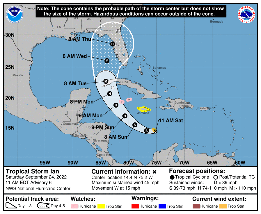
The 10am Saturday forecast track for Ian from the National Hurricane Center.

So hopefully we get some beneficial rain tonight, no storm damage, then can turn our attention to Actual Fall next week - and not a minute to soon!

Erik Proseus
MWN Meteorologist

----
Follow MWN on Facebook and Twitter for routine updates and the latest info!
Complete MWN Forecast: MemphisWeather.net on the mobile web or via the MWN mobile app
Download our iPhone or Android apps, featuring StormWatch+ severe weather alerts!
MWN is a NOAA Weather Ready Nation Ambassador Meteorologist Erik Proseus is an NWA Digital Seal Holder

Sunday, September 18, 2022

Hope you enjoyed #FalseFall, because #SecondSummer is now arriving!

Remember when fall came for a few days and we had low humidity, below average highs, and refreshing, if not cool, mornings? Yeah, forget about that because it’s in the past now. Whether you like it or not, summer is back! “False fall” is behind us and we are now entering our “second summer.” 
The weather cooperated with us this weekend for the Cooper Young Festival and Memphis football! Plentiful sunshine and highs in the low 90s occurred both days. Overnight lows were back to near 70 as well. It was hot, but still a great weekend for outdoor plans!

Monday-Wednesday

The heat from the weekend is just a taste of what is to come for the start of the work week. A strong high pressure over the southern plains is responsible for the heat we will be feeling. As a result, dry conditions and potentially record-breaking heat will move into the Mid-South. Monday’s record high is 97, Tuesday’s is 100, and Wednesday’s is 98. All of those are in jeopardy, in addition to the record for the latest 100-degree day, which is September 20th (Tuesday). Although the record-threatening heat won’t last too long, it’s still mid-September and we would typically expect average highs to be in the mid 80s.
The GFS model forecast for the pressure pattern in the upper levels of the atmosphere on Tuesday morning shows a massive dome of high pressure centered over south-central U.S. Yellow/orange colors indicate anomalously high pressure, and therefore heat. (WeatherBell)


Thursday-Friday

Surface forecast map valid 7am Thursday. A cold front will be just to our south by that time. (NOAA/NWS)

Thankfully, a cold front will move through the region early Thursday bringing drier air and a drop in temperatures, although it's doubtful there will be any precipitation, as rain chances remain to our north. When I say a drop in temperatures however, I do not mean below average… I mean the upper 80s to low 90s. 😒 While we will still be above average, the air will feel more comfortable. Overnight lows will also drop from the mid 70s into the mid 60s. 


Next weekend

The slightly cooler trend established after Thursday’s cold front will continue into next weekend, though it will still be too warm for late September. Highs will be in the low 90s and lows will be in the upper 60s. Just like this weekend, there will be decent weather for the Memphis football game against North Texas. It’ll be hot in the stadium and for tailgating though since the game starts at 2:30pm.

Owen Basselman
MWN Intern

----
Follow MWN on Facebook and Twitter for routine updates and the latest info!
Complete MWN Forecast: MemphisWeather.net on the mobile web or via the MWN mobile app
Download our iPhone or Android apps, featuring StormWatch+ severe weather alerts!
MWN is a NOAA Weather Ready Nation Ambassador Meteorologist Erik Proseus is an NWA Digital Seal Holder

Saturday, September 10, 2022

A rainy weekend, but early signs of fall are just around the corner!

Of course, as soon as we hit outdoor festival and football season, the rain shows up!

An upper level low is responsible for the today's dreary day. It is meandering by to our south, bringing rain in "Crazy Ivan"-style (like Russian subs in The Hunt for Red October that turn quickly to see what's coming from behind, or in the case of the weather, precipitation moving from east to west). 


Saturday

We'll see off and on rain chances this afternoon and evening, though likely not much in the way of thunder thanks to the morning clouds and rain putting the kibosh on instability as temperatures are likely to stay below 80. This will throw a bit of a wrinkle in outdoor plans at the Germantown Festival and Southern Heritage Classic among other events. Fortunately, it will be more of an annoyance and not dangerous. No major flooding issues are expected and lightning strikes should be rare.

Sunday

As we head into Sunday, that low starts to pull away but a few showers are still possible during the day. That is, until the afternoon, when a major trough taking shape over the northern plains pushes a cold front well south into the Mid-South by late afternoon, and then all the way to the Gulf Coast by Monday. That will result in scattered showers and thunderstorms Sunday mid to late afternoon or early evening. Until that front arrives, we'll be stuck in a fairly humid airmass with highs in the 80s.

The surface forecast for Sunday evening shows a cold front just southeast of Memphis with a sprawling high pressure system over the Plains. This front will introduce much less humid air and cooler temperatures early in the week. (NWS/WPC)


A Taste of early Fall this week!

Sunday night, things start to change - for the better! A dry continental airmass builds in rapidly behind said front, causing clouds to clear and dewpoints to plummet from near 70 to the mid 50s by Monday morning, and even lower beyond that. We'll wake up Monday morning to sunshine and morning temps in the lower 60s on a dry north breeze. Monday's high will be in the lower 80s, even with full sunshine, making it feel more like pumpkin spice season than late summer.


The rest of the week is shaping up to be really nice. With strong high pressure aloft and near the surface, the week will feature abundant sunshine and low humidity. That combination will mean warm daytime highs and cool morning lows early in the week, moderating to near 90 for the highs by week's end, but still comfortable mornings in the 60s through the end of the week. It is likely that many areas will see 50s on Tuesday morning, and possibly Monday and Wednesday mornings in the outskirts as well! After Sunday evening, no rain is in the forecast into the following weekend. 

Need to get the best return from a carwash? Monday is your day!

Forecast low temperatures on Tuesday morning, according to the NWS Blend of Models, shows widespread 50s across the Mid-South! (WeatherBell)

A reminder that if you appreciate the efforts of our team to keep you abreast of the latest weather for the area, and safe in the midst of storms, we have started a Patreon and would love to have you "throw a little in the tip jar!" We'll toss some extra benefits back your way on occasion for doing so, but you will also be contributing towards keeping our information flowing and free for all! Thanks much!


Erik Proseus
MWN Meteorologist

----
Follow MWN on Facebook and Twitter for routine updates
Complete MWN Forecast: MemphisWeather.net on the web or via the MWN mobile app
Download our iPhone or Android apps, featuring StormWatch+ severe weather alerts!
Support our continuous efforts to keep Mid-Southerners safe and informed via Patreon
 
MWN is a NOAA Weather Ready Nation Ambassador Meteorologist Erik Proseus is an NWA Digital Seal Holder

Thursday, September 8, 2022

August 2022 Climate Report for Memphis, TN

August Climate Recap

The heat of late June and July continued into the first week or so of August, before settling in near average for the next couple of weeks. The last week of the month turned to above average once again, with the end result being an average temperature for the month near one degree above normal. However, the average temperature was over four degrees cooler than July! For the period of "meteorological summer" (June-August), summer 2022 ended as the fourth hottest on record, behind only 1980, 2010, and 2011.


Precipitation for the month was fairly abundant in spots, but was beneficial for the entire metro. While nearly 6" fell at Memphis International Airport, just over 3.5" fell in Bartlett. The result of more precipitation was very evident in the change in the drought index maps, as shown below. Severe drought encompassed large sections of the metro at the start of the month, but by the end of the month, the worst drought was "moderate" in parts of northwest MS, while drought was completely removed in Shelby County. There was no severe weather during the month, though Flood Advisories were issued for heavy rain a number of times during the month and a Severe Thunderstorm Warning was issued for far eastern DeSoto and northern Marshall Counties on the 21st.

Comparison of the Drought Index from the beginning to end of August shows the results of a good amount of rainfall across the Mid-South, especially in west TN and northeast AR. (U.S. Drought Monitor)


Memphis International Airport, Memphis, TN

Temperature 
Average temperature: 83.0 degrees (0.9 degrees above average) 
Average high temperature: 91.8 degrees (0.3 degrees above average) 
Average low temperature: 74.1 degrees (1.5 degrees above average) 
Warmest temperature: 98 degrees (27th) 
Coolest temperature: 68 degrees (13th, 17th) 
Heating Degrees Days: 0 (0.0 above average)
Cooling Degree Days: 565 (37 above average) 
Records set or tied: Record low maximum temperature tied on the 17th (77 degrees).
Comments: 26 days saw high temperatures meet or exceed 90 degrees, which is 5.8 above normal, but no days reached 100 degrees. Meteorological summer (June-August) ended with an average temperature of 84.4 degrees, which is 4th hottest on record (1980, 2010, 2011).

Precipitation 
Monthly total: 5.95" (2.58" above average) 
Days with measurable precipitation: 10 (2.4 days above average) 
Wettest 24-hour period: 1.89" (10th-11th) 
Snowfall: 0.0"
Records set or tied: None
Comments: None 

Miscellaneous 
Peak wind: West-northwest/40 mph (8th) 
Average wind: 6.1 mph 
Average relative humidity: 69%
Average sky cover: 54%

 Click here for a daily statistical recap for Memphis International Airport.
 

Cirrus Weather Solutions / MemphisWeather.net, Bartlett, TN

Temperature 
Average temperature: 78.8 degrees 
Average high temperature: 89.7 degrees 
Average low temperature: 70.6 degrees 
Warmest temperature: 96.5 degrees (8th) 
Coolest temperature: 62.4 degrees (13th) 
Comments: None 

Precipitation 
Monthly total: 3.69" (automated rain gauge), 3.67" (manual CoCoRaHS rain gauge) 
Days with measurable precipitation: 11
Wettest date: 1.03" (21st) (via automated gauge) 
Snowfall: 0.0"
Comments: None

Miscellaneous 
Peak wind: West/30 mph (8th)
Average relative humidity: 81% 
Average barometric pressure: 30.01 in. Hg
Comments: None

Click here for a daily statistical recap for Bartlett, TN.
 

MWN Forecast Accuracy

MWN average temperature error: 1.89 degrees 
MWN forecast temperatures within 2 degrees of actual: 68% 
MWN average dewpoint error: 1.57 degrees 
MWN forecast dewpoints within 2 degrees of actual: 82% 

MWN's forecasts extend out five periods (2.5 days, or roughly 60 hours). Historical accuracy statistics can be found here.

--- 
Follow MWN on Facebook and Twitter for routine updates and the latest info! 
Complete MWN Forecast: MemphisWeather.net on the mobile web or via the MWN mobile app 
Download our iPhone or Android apps, featuring StormWatch+ severe weather alerts!
MWN is a NOAA Weather Ready Nation Ambassador Meteorologist Erik Proseus is an NWA Digital Seal Holder

Thursday, September 1, 2022

How you can support your trusted LOCAL weather source of 20 years

In a previous blog post, we outlined a series of changes that are in the works or recently completed in our organization. These include the addition of Richard as co-owner and meteorologist at Cirrus Weather Solutions, introducing new live streaming coverage via YouTube during inclement weather, and updates to the MWN and StormWatch+ apps. 

All of these changes - from new offerings to rebuilt apps and beyond - do not come without a cost. Operating MWN and StormWatch+ fulfills a passion Richard and I have to serve you and keep you safe, but also requires a great deal of commitment - of both time and financial resources - and it often interrupts daily life. (Our wives aren't exactly keen on us pulling from the household budget, while also breaking away from a family meal to "answer the weather bell"!) Our monthly expenses must continue to be maintained. Servers in the cloud that won't crash while pushing thousands of severe weather notifications aren't inexpensive. Neither is maintaining current versions of the tools we use to provide you the best possible forecasts and the most accurate severe weather updates. We also have plans for additional expansion that require a certain level of investment. 

That said, we have a couple of guiding principles that we refuse to violate:

1. We will NOT interrupt your access to potentially life-saving information with a paid advertisement.
2. We will NEVER sell your personal information in the name of profit (or even just to pay the bills). 

We are greatly appreciative of the amazing support you have offered over the years. It keeps us going when storms are bubbling at 2am and waking you up! But with only a couple of exceptions, nearly everything we have offered to this point has been without charge and without asking for anything in return, other than a referral to your friends and family. To be perfectly honest, we have stretched the dollars we receive, primarily through app purchases, a long way! 


So to that end, we are using this #901Day - a day in which "all things local" takes center stage - to announce the launch of our Patreon page. If you are not familiar with Patreon, it is a way to recognize the efforts of content creators of all types with small monthly donations. Think of it as a tip jar for great service. We're not looking to fund an MWN Owner's Cruise, nor are we going to take home a giant profit! We simply want to be able to continue to offer the reliable, trusted weather information you have come to appreciate, and also expand to a larger audience - with more tools at our disposal - to make the service even better. And we ask for your support in making this happen.

It's very easy to participate and we are intentionally making it very inexpensive as well. We will be able to recognize our donors in various ways (for those that choose), plus offer some perks for those who go a little above and beyond. All three "tiers" of support are less than you would spend for a single fast casual meal for one person! The point is, when many people band together to make seemingly insignificant contributions, great things can happen. We look forward to doing just that - using any donations you are kind enough to contribute to expand our offerings and to keep even more people safe and informed.

We are humbled by your ongoing support, and sincerely appreciative of your consideration in this new way!


By the way, we've recorded a video message that provides a little more detail on our history, and our future, and explains why each small commitment is important to the overall mission. We'd love for you to check it out here.

Gratefully,

Erik Proseus & Richard Hoseney
MWN Meteorologists

----
Follow MWN on Facebook and Twitter for routine updates and the latest info!
Complete MWN Forecast: MemphisWeather.net on the mobile web or via the MWN mobile app
Download our iPhone or Android apps, featuring StormWatch+ severe weather alerts!
MWN is a NOAA Weather Ready Nation Ambassador Meteorologist Erik Proseus is an NWA Digital Seal Holder