Sunday, March 27, 2022

More spring-like weather: warmer, then stormy, then cooler again

The springtime weather roller-coaster continues on as we head out of a dry but cool weekend and towards the end of March and beginning of April. While March came in like a lamb, it may be going out like a lion, as the potential for severe storms exists on Wednesday. Let's take it day by day.

Monday - Still cool

The Mid-South remains in a "northwest flow" regime to start the week with wind aloft from the northwest, keeping temperatures from rising much of any above normal and bringing periodic high cloud cover. However, with high pressure shifting to the east of us, we should see temperatures warmer than Sunday on an easterly wind. Looks for highs in the mid 60s, perhaps some upper 60s with just enough sunshine. After a cool start near 40 degrees in the morning, Monday night's conditions will be much milder with wind shifting to the southeast, keeping temps in the 50s overnight.

Tuesday - Warmer and breezy

Tuesday is really a setup day for Wednesday. Though likely to remain dry, a storm system moving out of the southwestern U.S. into the southern Plains will bring much more cloud cover and southerly wind will become gusty (to 25 mph) as humidity rises to more typical levels for this time of year. Look for highs to respond to the south wind and reach the mid to upper 70s. Can't rule out a stray shower, but it's unlikely. South wind will remain fairly strong Tuesday night as the southern Plains system approaches and the low level jet stream increases, and that will keep it warm overnight with temperatures remaining in the 60s.

Wednesday - Weather Alert Day!

All eyes are on Wednesday this week as it is likely to be an active weather day across the lower to mid Mississippi Valley, potentially including the Mid-South. Very strong south wind will continue to feed moisture into the region as a cold front moves in from the west. Look for wind gusts throughout the day to reach 35-45 mph, perhaps even touching 50 mph! The Trash Can Meter indicates your waste receptacle will be over yonder and may even roll down in the holler!


As of Sunday afternoon, it appears the ETA for stormy weather will be in the afternoon hours, most likely from around school dismissal time through rush hour, though that could easily still change by a couple of hours. 

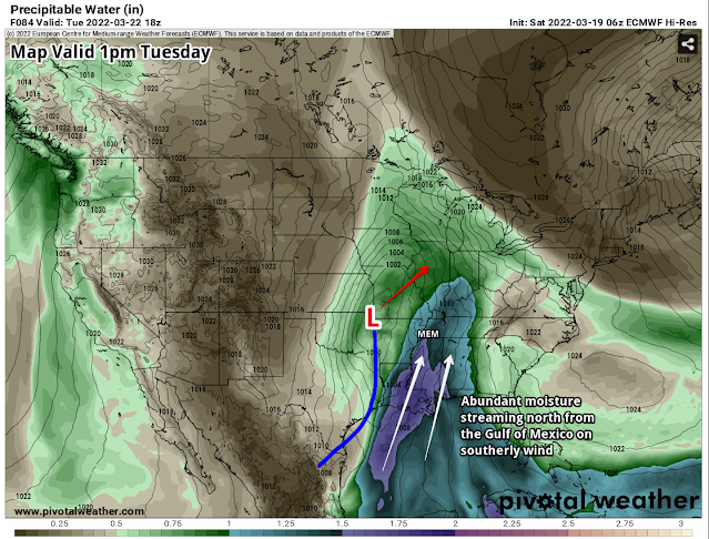
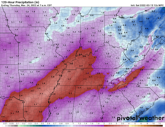
The model comparison above shows forecast precipitation between 1pm and 7pm Wednesday between the European model (left) and American GFS model (right). There is strong agreement between the models on timing Wednesday afternoon. Drilling down a bit closer, we expect mid to late afternoon to be prime storm hours. (WeatherBell)

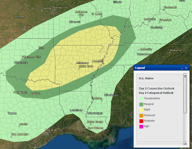
The Storm Prediction Center has been highlighting a potential severe weather outbreak for 3 days now, and as of today, indicates that is most likely to occur just to our south, though severe storms are entirely possible in the Mid-South as well. 


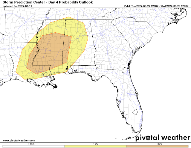
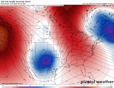
The severe weather outlook issued Sunday for March 30 indicates that severe storms appear likely across portions of AL, most of MS and western AL. Severe weather is possible however as far north as the the Mississippi/Ohio River confluence and across all of eastern AR. (NWS/SPC)

While this is still 72 hours or so out, the most likely scenario appears to be a squall line with high wind over 60 mph, though it is possible that a few rogue storms could form ahead of the line. With wind screaming from the surface up, and plenty of shear, tornadoes are a distinct possibility as well.  They would be most likely in rogue cells that form, but also possibly embedded within a squall line. Areas just to our south are the most favored, but this scenario definitely bears watching. 

The main limiting factor right now appears to be storm fuel, or instability. If we get some morning sunshine and temperatures approach 80 degrees ahead of the system, that higher risk zone could expand further north. Updates on our severe weather threat, as well as wall-to-wall coverage on Wednesday, will be provided on our social media feeds linked below.

The arrival of the cold front by early evening will bring an end to this round of severe weather and usher in cooler air Wednesday night on gusty west wind. as temperatures fall back into the 40s by Thursday morning.

Thursday/Friday - much calmer

It looks like seasonally cool and dry weather is on tap to end the week and start the month of April - no foolin'. Morning lows in the 40s and afternoon highs in the mid 60s with a cool breeze on Thursday in particular. 


Next weekend and beyond - Overall cool

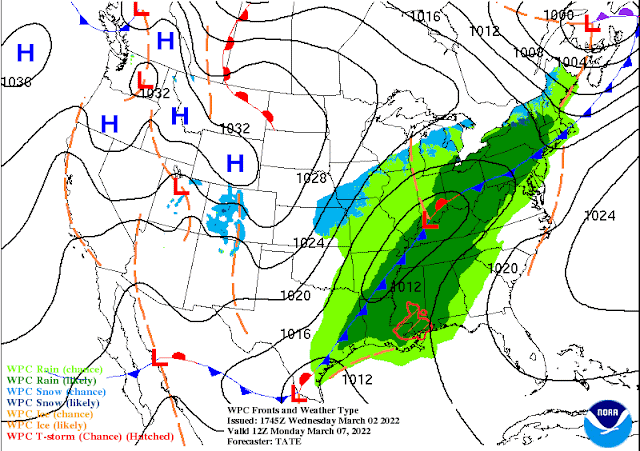
Computer models are not in good agreement on next weekend at this point, but hint at a possible system moving by to our south, which could throw some showers over us Saturday and maybe Sunday. It will remain cool with temperatures similar to the end of the week - highs in the mid 60s.  Overall, the start of April is forecast to be cooler than average (which is near 70 for highs and near 50 for lows). No additional major storm systems are on the horizon out to about 10 days after Wednesday.

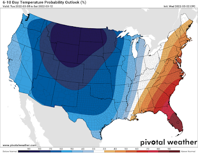
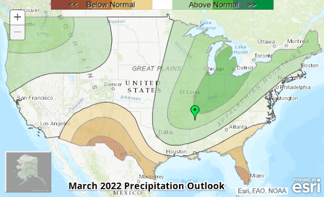
Cooler than average temperatures are favored for the Mid-South to start April with precipitation generally near average. (NWS/CPC)

Erik Proseus
MWN Meteorologist

----
Follow MWN on Facebook and Twitter for routine updates!
Download our iPhone or Android apps, featuring StormWatch+ severe weather alerts!
MWN is a NOAA Weather Ready Nation Ambassador Meteorologist Erik Proseus is an NWA Digital Seal Holder

Saturday, March 19, 2022

Spring officially arrives! Tuesday is this week's "weather aware" day

Equinox vs. Equilux: a primer

We've experienced #FakeSpring (maybe a couple times), "Fool's Spring," "Spring of Deception," and even meteorological spring over the past month or so. But as of 10:33am Sunday, REAL spring arrives! Astronomical spring, a.k.a. the vernal equinox, marks the time when the sun passes directly over the equator heading north, resulting in longer days and more direct sunlight in the northern hemisphere. 

But did you know that the equinox is NOT when daylight/darkness is equal over the course of a day? The equilux, the actual day when the sun is above the horizon for the closest to 12 hours, varies by latitude. In Memphis, that actually happened this past Wednesday, when the sun was above the horizon for 11 hours, 59 minutes, and 51 seconds. The sun set Wednesday night at 6:08pm and rose Thursday morning at 6:08am!

The equilux is now behind us, with increasing daylight each day, while the equinox occurs Sunday morning. 

This weekend: beautiful spring weather

So now that we have equinox and equilux straightened out, today is officially the last day of winter and we're starting with conditions that feel like it - grey sky, chilly breeze, temperatures in the 40s. But that will change pretty quickly as Mother Nature takes a look at her astronomical calendar and realizes there is some catching up to do! Sunshine breaks out by mid-day with temperatures responding to the March sun and warming to 63°, just shy of the average high for today. For the first day of spring, we can't ask for much better - sunshine, a cool but about average morning low in the low 40s, and high temperatures that warm to 73° with a light southwest wind. I think we'll take it!

Early week spring storm

Monday will continue the above average temperatures with highs in the lower 70s, but signs of a spring-like storm system will be brewing - from the high clouds streaming overhead to the increase in southeasterly breezes. As that storm system brews over the southern Plains, our initial rain chances arrive Monday night with mild temperatures in the mid 50s.

The NWS surface weather map valid Tuesday morning. A pair of cold fronts are to our west, while southerly wind ahead of the low pressure center brings rain and scattered thunderstorms to the Mid-South. (NWS/WPC)

Tuesday is the one day this week that we need to be "weather aware." As low pressure moves northeast from the southern Plains towards the Mid-Mississippi River Valley, a surge of moisture on strong south wind will overspread the Lower Mississippi Valley and Deep South. That is shown below by "precipitable water" values, which measure total atmospheric moisture. Values near 1.5" (very high for this time of year) will reach as far north as the metro, indicating plenty of water in the air to rain out.

The overnight European model valid mid-day Tuesday shows low pressure moving by to our northwest, a cold front draped through east TX moving east, and abundant moisture (color shading) surging north from the Gulf of Mexico. Values just shy of 1.50" in Memphis area near the 99th percentile climatologically, or about the maximum we would typically observe in mid-March. (Pivotal Weather, annotated by Erik Proseus)

We'll also see instability increase modestly on those strong southerly winds. Though the most favorable concentration of moisture, instability, and wind shear for the production of strong to severe storms will be to our south in MS and AL, we're likely to see a line of storms as well, though perhaps not quite with the "oomph" of those to our south. We'll still need to be watching for the possibility of scattered damaging wind gusts though, especially with the cold front in the afternoon hours.

The NWS Storm Prediction Center highlights areas just to our south for the likelihood of severe storms on Tuesday. For our area, thunderstorms are expected, but won't be as intense. (NWS/SPC)

Rainfall totals through Thursday morning, as projected by the NWS, show a swath of 2-4" across the Mid-South. Most falls on Tuesday. (NWS/WPC)

Overall, our main threat Tuesday is going to be very heavy rain during the daytime that could result in minor to perhaps moderate flooding of low-lying and drainage areas, as well as smaller streams and creeks. Rainfall totals from this system (Monday night through Tuesday night) will likely range from 2-4" with locally higher amounts. In addition, a few storms could produce strong wind gusts, in addition to dangerous lightning. I expect we will be in a level 1 (Marginal) risk of severe weather on Tuesday and would not be surprised if at least our north MS counties were in a Slight Risk, or level 2.

Mid-week: cool with more clouds than sun

Behind the system Tuesday, a trough of upper level low pressure will linger for a couple of days, with an upper level low pressure center moving nearby on Thursday. This pattern favors cooler than average temperatures, more clouds than sunshine, and possibly a few light rain showers. Look for highs in the upper 50s to lower 60s these days with lows in the mid 40s Thursday morning. Not the beautiful spring weather we'd like, but spring is not all sunshine and unicorns as we know! It's a transition season.

The pressure pattern from Monday evening through Friday evening at 500mb (about 18,000') from the European model shows the presence of abnormally low pressure (blues to purple) affecting our area through the end of the week. This will result in lingering clouds and cooler than average temperatures.

Next weekend: sunshine returns!

By the end of the week, upper level high pressure builds back over the area with moderating temperatures and sunshine to end the week and through next weekend. High temperatures will be back into the 60s to near 70, though cool mornings linger. Hey, if you have to pick your days for sunshine, might as well be the weekend!


Erik Proseus
MWN Meteorologist

----
Follow MWN on Facebook and Twitter for routine updates and the latest info!
Complete MWN Forecast: MemphisWeather.net on the mobile web or via the MWN mobile app
Download our iPhone or Android apps, featuring StormWatch+ severe weather alerts!
MWN is a NOAA Weather Ready Nation Ambassador Meteorologist Erik Proseus is an NWA Digital Seal Holder

Saturday, March 12, 2022

February 2022 Climate Report for Memphis, TN

February Climate Recap

A cool January continued right into February, which can best be described as cold, wet, and memorable! Though there were a couple of short warm spells with highs in the 60s and 70s, the average temperature for the month was more than 2 degrees below normal, with low temperatures accounting for most of that deficit, averaging over 3.5 degrees below normal. There were two periods in particular during the month that were significantly below average - one that started with a generational ice storm, and another late in the month that had a bit of snow. 

The "memorable" event is still in the cleanup stages as perhaps the most impactful ice storm since 1994 hit the city on the 3rd. Nearly 2" of liquid water fell with temperatures right at to just below freezing that day. Overall, most areas saw anywhere from 0.25" to 0.75" of ice accumulation and many reports of thunder-sleet at times as well. Tens of thousands of trees were damaged, leading to a massive cleanup effort that continues into mid-March. In addition, nearly a quarter million Memphis Light Gas and Water customers lost power, with the overall restoration effort taking a week and a half. 

A birds-eye view of the city after the generational ice storm on February 3. Photo courtesy of The Daily Memphian/Patrick Lantrip. Used with permission.
In addition to heavy precipitation early in the month, thunderstorms also dropped an inch of rain on the 17th and produced additional widely scattered tree damage due to wind, then another very wet week occurred starting on the 22nd with over 4.5" of rain falling through the 27th. Despite being the shortest month, it certainly provided plenty of impactful weather events!

Memphis International Airport, Memphis, TN

Temperature 
Average temperature: 44.0 degrees (2.1 degrees below average) 
Average high temperature: 54.9 degrees (0.6 degrees below average) 
Average low temperature: 33.0 degrees (3.7 degrees below average) 
Warmest temperature: 75 degrees (16th) 
Coolest temperature: 22 degrees (4th, 5th, 6th) 
Heating Degrees Days: 582 (50 above average)
Cooling Degree Days: 0 (2 below average) 
Records set or tied: None
Comments: 14 days saw temperatures fall below freezing which is 4 above average

Precipitation 
Monthly total: 8.02" (3.47 " above average) 
Days with measurable precipitation: 10 (0.1 days above average) 
Wettest 24-hour period: 2.31" (23rd-24th) 
Snowfall: Trace (1.0" below average)
Records set or tied: Tied record daily snowfall - Trace (23rd)
Comments: A trace of snow was recorded on the 3rd, 4th, and 23rd. 0.71" of freezing rain accumulated on the 3rd.

Miscellaneous 
Peak wind: Southwest/49 mph (17th) 
Average wind: 9.0 mph 
Average relative humidity: 64% 
Average sky cover: 50%

 Click here for a daily statistical recap for Memphis International Airport.
 

Cirrus Weather Solutions / MemphisWeather.net, Bartlett, TN

Temperature 
Average temperature: 42.3 degrees 
Average high temperature: 54.2 degrees 
Average low temperature: 30.6 degrees 
Warmest temperature: 72.8 degrees (11th) 
Coolest temperature: 17.6 degrees (5th) 
Comments: None 

Precipitation 
Monthly total: 7.14" (automated rain gauge), 8.40"(manual CoCoRaHS rain gauge) 
Days with measurable precipitation: 9
Wettest date: 2.03" (22nd) (via automated gauge) 
Snowfall: Trace
Comments: 0.3" of freezing rain on the 3rd. Traces of snow occurred on the 3rd and 4th.

Miscellaneous 
Peak wind: South to southwest/29 mph (16th & 17th)
Average relative humidity: 71% 
Average barometric pressure: 30.22 in. Hg
Comments: None

Click here for a daily statistical recap for Bartlett, TN.
 

MWN Forecast Accuracy

MWN average temperature error: 2.80  degrees 
MWN forecast temperatures within 2 degrees of actual: 52% 
MWN average dewpoint error: 2.77 degrees 
MWN forecast dewpoints within 2 degrees of actual: 53% 

MWN's forecasts extend out five periods (2.5 days, or roughly 60 hours). Historical accuracy statistics can be found here.
 

Climate Outlook - March 2022

The March climate outlook for the United States from the Climate Prediction Center is shown below. Above average temperatures are forecast for a large area from the Mid-Atlantic through the Ohio River Valley and southeast U.S. into the south-central U.S with strongest chances in the Deep South and Florida. Below average temperatures are expected across the Northern Rockies and west coast. Odds favor above average temperatures (46%) for Memphis over the course of the month versus a 22% chance of below average temperatures. The average temperature for March is 54.2 degrees.


Precipitation is expected to be above normal from the Northeast U.S. into the Midwest and south through the Mississippi River Valley, as well as the Pacific Northwest. Highest odds of wet conditions are in the Great Lakes and Ohio Valley. Below average precipitation is forecast for the Rio Grande Valley into the Desert Southwest, as well as in Florida. For Memphis, odds favor above average precipitation (46%) versus a 21% chance of below average precipitation, which historically averages 5.74 inches in March.

--- 
Follow MWN on Facebook and Twitter for routine updates and the latest info! 
Complete MWN Forecast: MemphisWeather.net on the mobile web or via the MWN mobile app 
Download our iPhone or Android apps, featuring StormWatch+ severe weather alerts!
MWN is a NOAA Weather Ready Nation Ambassador Meteorologist Erik Proseus is an NWA Digital Seal Holder

Wednesday, March 9, 2022

Winter's last gasp... snow is in the Friday night forecast

UPDATED - 3/10/2022, 7:00PM

The snow forecast remains on track for Friday evening and as discussed in last night's post seen below. I'll skip the setup, which is discussed a bit more in the post Wednesday night and cut right to the chase.

A Winter Weather Advisory is in effect for the entire metro from 6pm Friday to 6am Saturday, which means this winter event is likely to be an inconvenience, but not necessarily a threat to life and property. 

The NWS Winter Storm Severity Index (WSSI) indicates a likelihood of minor impacts across the Memphis metro, meaning the snow could result in an inconvenience to daily life.

Rain chances increase by late afternoon with rain changing to snow from west to east around 6pm as temperatures drop from their high near 60 degrees to the mid 30s. (This is a bit earlier than mentioned last night.) We'll get a few hours of snowfall before it starts to taper off by midnight, with a few flurries sticking around into the wee hours of Saturday as temperatures continue to fall into the 20s on strong northwest wind.


Forecast radar from the mid-day run of the HRRR model, which shows snow moving through the Memphis area between about 6pm Friday and 1am Saturday. (WeatherModels)

Snowfall totals will likely be around or just above 1" in the immediate metro with potential for up up to 2" more northeast of the city and up the I-40 corridor further into west TN. This amount of snow is most likely on grass and exposed surfaces, not on roads, which should fare decently given temperatures in the mid 50s to near 60 in the early afternoon hours and early day sunshine. During the period of heaviest snow in the evening hours, some accumulation of wet snow or slush is possible on residential and secondary roads, as well as overpasses and bridges. Main roads and interstates could also get a bit of slush if the precipitation is heavy enough during the height of the event. 

The NWS forecasts about a 40-50% chance of an inch of snow, though the consensus of available model data is running about 1.0-1.5" for the event. (NWS)

You'll want to be cautious of the road conditions Saturday morning, as temperatures plummet through the 20s overnight. Despite wind that will help dry roads, slushy areas or standing water could flash freeze. Sunshine and temperatures in the mid 30s will be very chilly Saturday, but it will be enough to take care of any slick spots on the roads.

Stay with us on social media throughout the event for the latest conditions and last minute updates! Links are at the bottom of this post or use the free MWN app to follow our social channels.


ORIGINAL POST - 3/9/2022, 8:00PM

Just when you thought winter was over....
Last week's beautiful weather gave way to a chilly and damp day Monday, but the sun shone again today and temperatures are warming with more sunshine tomorrow as highs reach the lower 60s. Friday will start off like a decent spring day with sunshine and decent temperatures again... but what's lurking just over the horizon is "Third Winter," which will last for about 48 hours. We can then begin another warm-up and "The Pollening" as we head into real spring! Tonight's blog will focus specifically on those 48 hours, and really mainly the first 6-12 of them... and boy will they be eventful! 

Friday overview

After reaching about 60 degrees on Friday, a cold front will move through the Mid-South. You'll note a wind shift to the northwest and gusty wind as skies cloud up. Temperatures drop very quickly behind the front - falling through the 50s in the afternoon, and then the 40s and 30s in the evening. Initial rainfall that starts by early evening is likely to change quickly over to snow, most likely by around 9pm. Snow could be steady to maybe even heavy at times for a couple of hours before tapering off as quickly as it arrived, shortly after midnight. The 10pm to midnight timeframe is our best educated guess at when the steadiest accumulating snow will fall.  If you are heading to the Grizzlies game that evening, it could look like a snow globe outside after the streamers fall inside.


After the snow...

Temperatures will continue to fall on gusty wind and bottom out Saturday morning in the low to mid 20s. The sun will be back out Saturday, but cold air pouring in from the northwest on gusty wind will likely keep the mercury from reaching 40 degrees Saturday afternoon. (And in mid-March, with full sunshine, it's pretty hard to stay below 40!) Another cold night is in store Saturday night with lows in the mid 20s once again, but we'll start to moderate during the day with continued sunshine and high pressure moving to our east, allowing southerly wind to warm us into the upper 50s. 

So let's answer some questions about our brief visit from "Third Winter"

Q: How much snow will we get? Any ice?
A: If it weren't falling on warm roads and ground, it might amount to a couple of inches. Instead, roads are probably going to survive pretty well as most of the snow melts on contact. Grass/mulch/bare ground and exposed objects could see an inch of snow cover, perhaps more north of the Bluff City, and likely less in north MS. The cold air arrives so quickly (near the ground and aloft) that ice is not expected.

Forecast snow totals for Friday evening from the NWS (as of Wednesday afternoon)


Q: What is the confidence factor in this event?
A: We're still a couple days out, but models are pretty well in alignment, and all have been poking at this event for a few days now. Confidence is high that we'll see snow and the overall timing (primarily 9pm-midnight), and medium in the amounts. I'm a bit less confident it what it will look like Saturday morning when we wake up.

"Boom" forecast for Friday evening from the NWS (as of Wednesday afternoon). These amounts have a 10% chance of occurrence and are considered a "reasonable worst case."


Q: What about freezing overnight with lows well down into the 20s?
A: That is one of my biggest questions marks. I expect that most roads will be fine. There will be lots of wind and cold but dry air once the system departs Friday night. Some areas that get puddles before the snow starts could "flash freeze" overnight as the temperature drops so quickly. If you will be out early Saturday morning, watch for pockets or patches of ice. I would not cancel any travel plans Saturday if you are headed somewhere warmer (and I also won't blame you!).


Q: Why, Erik?? It's spring break weekend!
A: I know right? I'm in sales not production, and there are times the family goes hungry... 

It's honestly not completely unusual to get a "last gasp" of winter, including snowfall, in early March. This is a bit late, but the latest recorded inch of snow is March 29. And despite the fact that any measurable accumulation on Friday will set a snowfall record for the date, there are actually four events on record that occurred later in March that dropped more than 4 inches. FOUR INCHES! So while it might be rare, it's certainly not unprecedented. So let's get it over with and move on to...


Monitor our social media feeds for the latest information and any changes between now and Friday night. 

Erik Proseus
MWN Meteorologist

----
Follow MWN on Facebook and Twitter for routine updates and the latest info!
Complete MWN Forecast: MemphisWeather.net on the mobile web or via the MWN mobile app
Download our iPhone or Android apps, featuring StormWatch+ severe weather alerts!
MWN is a NOAA Weather Ready Nation Ambassador Meteorologist Erik Proseus is an NWA Digital Seal Holder


Saturday, March 5, 2022

Spring warmth brings spring storms, and don't put those sensitive plants out just yet!

What a week (in a great way)! High temperatures the past four days have looked more like April than March - 71, 77, 80, 79 - and we're on track for another day in the upper 70s today despite the arrival of high clouds ahead of our next cold front. Sunshine and warm high pressure overhead have contributed to these well above average marks, and we even tied a record on Thursday with that high of 80 degrees! 

That kind of weather has brought on a case of spring fever for many of us, but while a little spring cleaning and preparation is a great idea, don't start putting those plants in the ground just yet! More on that in a minute, but first let's talk about how this early streak of fine weather ends (because you know it will...).

This weekend - windy and warm

The arrival of high clouds and a very gusty wind today signal the approach of the next weather-maker that will undo the spring conditions we've had this week in favor of early spring storms. That front will drop to the Missouri-Arkansas border by Sunday morning, but stall out for about 24 hours before finally making a significant push through the area. The upper level pattern is responsible for the stalling, and ultimately its resumption of southeastward movement through the Mid-South. 

Surface weather map on Sunday morning shows a front stalling to our north and scattered rain around the area south of it. We'll still be in very mild air. (NWS)

Ahead of it, look for strong southerly breezes to continue this weekend and clouds to build as moisture from the Gulf of Mexico arrives on strong wind. That means very warm temperatures in the 70s during the day and 60s overnight tonight. With the moisture increasing, we'll see spotty showers around the area this evening and overnight. 

The HRRR forecast model radar for 5pm tonight through 6am Sunday shows spotty showers becoming a bit more numerous by morning. (WeatherBell)

By morning, it appears activity will become a bit more widespread as the front gets closer, but still scattered. A few thunderstorms could also mix in, mainly north of the I-40 corridor, on Sunday morning to early afternoon. These are NOT expected to be severe. By Sunday mid-afternoon, upper level high pressure builds briefly and squashes our rain chances a bit more heading into Sunday evening. Look for another day or wind gusts to 25+ mph tomorrow with highs again in the upper 70s. So to recap - spotty showers this evening, increasing to scattered coverage with a chance of lightning on Sunday, drying for while by late afternoon.

The rest of the day Sunday through Sunday night, according to the HRRR model. Daytime showers lift north Sunday evening, only to orient into a line to our north and west overnight. Much of the night could be dry. (WeatherBell)

Sunday night/Monday storms

Sunday night is when the cold front finally gets some assistance front a shift in the upper levels as a trough approaches. That will cause it to accelerate southeast. Rain chances respond accordingly after midnight Sunday night and peak Monday morning, likely starting during the morning rush. In addition, with upper level support, strong wind at all levels, and a modicum of "storm fuel" available thanks to warm temperatures (mid 60s) and dewpoints (low 60s) overnight, thunderstorms appear likely. A squall line is likely to form to our northwest overnight and move into the Memphis area, probably in a slightly weakened state owing to the time of day, Monday morning. Current broad-brush timing is 6-10am and will be refined. 

Switching to the NAM3 model to show what radar may look like from 3am to 3pm Monday. The squall line (which may look a bit different than this - the NAM3 tends to underestimate this far out) moves through  Monday morning in the 6-10am timeframe, then showers continue as temperatures drop. (WeatherBell)


A few storms in that line could be severe with strong wind gusts the main concern, though a non-zero spin-up tornado chance also exists. We're currently on the eastern edge of a Level 2 Risk of severe storms, with the largest part of the risk over southern MO in to AR.

A Slight Risk (level 2) for severe weather is forecast roughly from the Memphis area west for Sunday night and early Monday morning. Our main timeframe of concern is 6-10am. Strong wind gusts are possible and a brief spin-up tornado can't be ruled out. (NWS/SPC)

Once the line moves through, those gusty south winds switch direction to the northwest, dropping temperatures as showers continue. Monday's high in the upper 60s to near 70 occurs ahead of the front, with temperatures falling into the 50s quickly that afternoon, and 40s by Monday evening. 

Mid-week cooldown

That cooldown leads us to a period of below normal temperatures starting Tuesday. There will still be clouds around as southwest flow aloft will be pushing another rainy system through Tuesday night. Look for Tuesday morning lows in the mid 30s with wind chills in the 20s and afternoon highs in the mid 50s. Most of the rain Tuesday night falls to our south, but a consensus of models brings some light rain into the city. We'll keep an eye on it as there are outliers. By Wednesday morning, with lows in the low 40s, it appears the southerly storm track dries up and we get a couple of decent days. Wednesday's high will be in the upper 50s, while Thursday sees sunshine and highs in the mid 60s.

Late week Arctic blast

By late Thursday, we'll be watching an even stronger front dive out of the central U.S. towards the  eastern U.S. with a significant push of cold air behind it. Depending on the amount of moisture ahead of it, we could see some Friday showers, but the big news is likely to be a blast of cold air that reminds us we are not yet to our average "last freeze" date just yet (March 18 in the city)! By next weekend, early indications are that lows drop back into the 20s with highs in the 40s again. 

The European model ensemble currently predicts with near certainty low temperatures next Saturday morning being below freezing. (Probability of 32° or lower near 100%.) Better hold off on planting for a while! (WeatherBell)

It is not atypical for freezes to occur well into mid and even late March, though the duration of cold air gets shorter, and the warmth that typically follows a bit warmer than in February. So let's put the brakes on the spring planting for at least a few more weeks, then evaluate what the end of the month looks like before deciding on a time to plant.


Erik Proseus
MWN Meteorologist

----
Follow MWN on Facebook and Twitter for routine updates and the latest info!
Complete MWN Forecast: MemphisWeather.net on the mobile web or via the MWN mobile app
Download our iPhone or Android apps, featuring StormWatch+ severe weather alerts!
MWN is a NOAA Weather Ready Nation Ambassador Meteorologist Erik Proseus is an NWA Digital Seal Holder

Wednesday, March 2, 2022

"Spring" is here! But is it here to stay?

The calendar has turned to March and the start of meteorological spring (which was March 1, a convenient day for weather peeps to divide the calendar for calculation purposes) is clearly apparent as a cold end to February (remember than thunder-sleet last week?) quickly melted away under the warm sunshine! We've got more of this to come in the next few days, but is it here to stay?


Rest of the work week

Let's start with the short-term, which is a continuation of the past couple of glorious days, despite a weak cool front moving in on Thursday. That front will be dry - and to be perfectly honest, cloud-free - and have little effect on the temperatures. Overnight lows will continue to moderate as dewpoints slowly creep up. Look for mid 40s Thursday morning and mid 70s in the afternoon with light wind shifting to the north. Thursday night will be a few degrees warmer, thanks mainly to the arrival of some high clouds late in the night. Those high clouds will partially filter the sunshine on Friday and are a harbinger of things to come. However, it will still be warm and dry to end the week as high pressure rebuilds to our east, bringing back the south wind. 

This weekend

Those clouds on Friday will thicken heading into the weekend. Dewpoints continue to rise as southerly flow becomes deeply established Saturday. Wind gusts could top 30 mph and a few stray showers are possible towards the end of the day as a cold front approaches. Look for temps to again reach well into the 70s after only bottoming out in the mid 50s Saturday morning. 

It looks like showers will become more scattered Saturday night with very mild conditions - 60s all night long. As the front gets much closer to the region Sunday, we'll definitely see an uptick in rain chances. In fact, with dewpoints likely near 60 degrees and a front not far off, scattered thunderstorms are also looking like a decent bet. If you need some outdoor time this weekend to spring clean, Saturday is your best choice, though don't overlook that wind. We'll border on #SkirtAlert criteria and the Trash Can Meter will be well into the "Can done turnt over" range! 


The cold front will move into the Mid-South Sunday overnight, so expect higher chances of thunderstorms, heavy rain, and potentially a few strong storms with very warm temperatures. The Storm Prediction Center has issued a Slight Risk of severe storms for Sunday night over AR right up to the Memphis metro. Worth watching, but not overly concerning at this point.

A Slight Risk (level 2) of severe weather is forecast Sunday night from far west TN across AR into the ArkLaTex region. Stay tuned! (NWS/SPC)


Start of next week

The cold front is currently forecast to move through the Memphis area by both the American and European models on Monday morning. That could still obviously change, but for now, that's our best guess. It will likely be accompanied by thunderstorms, a few of which could be strong given the energetic wind field and favorable moisture profile. The main question mark lies in the degree of instability, which is always a question this time of year it seems. The timing of the front (morning) favors lower storm fuel. If it were to be delayed and we got to the 70s again Monday for instance, I'd be a bit more concerned.

The NWS surface map for Monday morning shows the cold front on our door step with a wide swath of rain over the eastern U.S. Colder air sits just behind the front. (NWS)

Once the front moves through, rain looks to stick around Monday with a bit cooler temperatures. We cold see temperatures dropping from the 60s in the morning to the 50s in the afternoon. Behind the front, a cooler airmass moves in, but compared to late February, it will be manageable. Look for partly sunny skies Tuesday and Wednesday and highs in the 50s with lows dipping into the 30s. The overall pattern still favors slightly wetter than average for next week, so I'm not convinced rain chances don't return by mid to late next week.

The NOAA/CPC temperature outlook for next Tuesday-Saturday shows most of the cold air to our west, but starting to creep east. After this week, 70s are probably gone for a little while.


What season are we in?


So are we done with winter? On the above (very accurate, tbh) list, I'd put this week of 70s at "spring of deception." I guess it depends on how you define winter. I do think we've probably seen the last of our chances of impactful winter weather (thank goodness!). That doesn't mean we can't see a quick shot of winter shenanigans mixing in behind a potent cold front for another couple weeks, but it's doubtful. Freezing temperatures behind us? We're likely not quite there yet. 

The average date in the city for the last freeze in the spring is March 18 - still more than two weeks away. It's later than that in outlying areas, and that is just the average. We certainly have had some very cold mornings around Easter before, even when it falls in early April. I would not start going crazy with spring planting yet, but in a couple of weeks, we should be getting close! 


Erik Proseus
MWN Meteorologist

----
Follow MWN on Facebook and Twitter for routine updates and the latest info!
Complete MWN Forecast: MemphisWeather.net on the mobile web or via the MWN mobile app
Download our free iPhone or Android apps, featuring SW+ Alerts severe weather notifications!
MWN is a NOAA Weather Ready Nation Ambassador Meteorologist Erik Proseus is an NWA Digital Seal Holder