
Another round of winter weather is bearing down on the Mid-South, the third in the first two weeks of the new year. Winter held off until the calendar turned but, with the exception of a few nice days sprinkled in, has dominated the month of January to this point. It seems we've either had one not far in the rearview mirror, or another lurking just around the next bend since we put that 79° New Year's Day behind us!
What's causing all the fuss?
I'll start by quickly setting the stage, which hopefully will provide some context (or an excuse perhaps) for why this one is just so darn difficult to forecast. We'll need to look upstream two different directions to see how this system plays out in the big picture (but of course the devil is always in the details). First, in the upper levels, a developing trough and "ball of energy" will quickly south through the Plains over the next 24 hours, make a hard left turn, and pass just to our south before turning left again and heading up the eastern seaboard Sunday into Monday. You can see it in the animation below:
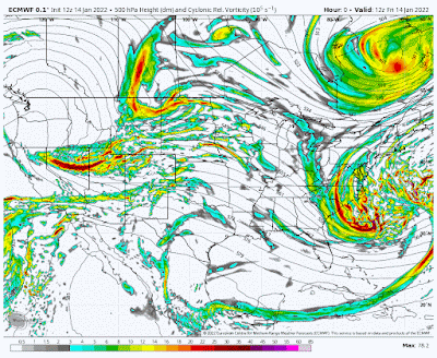 |
| The European model shows the progression of the upper levels of the atmosphere as an upper low drops south through the Plains (counter-clockwise rotating area in yellows and oranges) and then turns east just south of Memphis while strengthening (darker reds). (WeatherBell) |
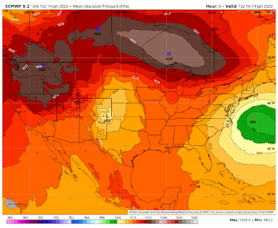 |
| At the low levels, surface low pressure moving east over TX passes by to our south (in yellow - a favored winter path for snow occurring on the north side of it) before strengthening (greens) as it heads up the east coast. (WeatherBell) |
The complicating factors in this are the paths of these two systems and their synchronizing as they band together before moving by just to our south. This is not a "typical" setup for our area, and when you throw in cold air, it complicates things. The upper level system will bring its own moisture as it dives south, but as it phases with the surface low, it taps additional moisture drawn up from the Gulf of Mexico as well. All of this sets the stage for a doozy of a winter weather system somewhere.

Because of the complicated nature of the pattern, our computer models - even the best ones that specialize in the short-term - are really having an issue with producing a coherent forecast. Some details are fairly concrete; others (that probably matter most to our general readers) are still "up in the air" (literally). Let's talk through what we know and don't.
What we know (or think we do)
A Winter Storm Watch is in effect for the entire metro except Tate and Tunica Counties in Mississippi. Advisories or warnings will be hoisted soon for areas most likely to see moderate to significant disruptions to travel and commerce.
First it's going to rain, probably a decent amount, on Saturday as the systems approach and converge and temperatures are still warm (i.e., 40s). It won't be a great day to prepare, but at least you have all day Saturday before it arrives. Those temperatures fall by late afternoon into the 30s and by late evening will reach a point where rain will start to transition to snow, starting up north and working its way south. This is likely to occur between about 9pm and midnight. A brief period of sleet or freezing rain is possible during the transition. We judge this threat to be low. Roads should continue to be fine through midnight as pavement will be warm enough to melt anything that falls.
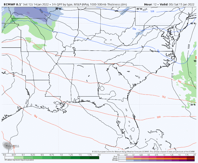 |
| The European model's forecast of how precipitation will evolve from Friday evening through Monday morning as low pressure passes by to our south, wrapping moisture into the colder air on its north side (snow = blue, rain = green). (WeatherBell) |
The heaviest frozen precipitation will likely occur between midnight and 7am as temperatures fall below freezing into the upper 20s, before snow tapers off as the system moves to our east. By midday Sunday, most lingering light snow will be done and we could even see some afternoon sunshine. Temperatures may rise above freezing by a few degrees in the afternoon. However, it will also be windy throughout this event - Saturday through Sunday with gusts above 30 mph possible overnight. Wind chills will be brutal.
What we don't know
The nature of a system with as much energy as this one, pivoting counter-clockwise around the area on a still TBD path, means there will be some areas that see a good deal of snow from "banding" that takes place. Typically narrow, these bands can basically vomit snow over a small area, falling at a rate that reduces visibility and makes travel treacherous, easily accumulating on paved surfaces. In other areas nearby, it may be lightly snowing with no major issues. These bands cannot be forecast much in advance, if at all, but we can define a general area where they may occur.
These bands are what makes forecasting snow amounts so difficult in this scenario. Everyone will not get the same thing. One part of town may get twice as much as another just from one or more of these bands settings up. So the main thing we DON'T know is how much snow will fall in your backyard. Some of you will boom; others will bust. I'll get complaints and kudos from both sides. It goes with the territory.

Forecast Details
What and when: Rain changing to snow by midnight Saturday night, locally heavy through dawn, tapering Sunday morning
How much: Generally 1-4"with the greatest probability of the higher amounts east of Memphis.
Good for snowball fights and snowman building? Yes, this will be a wet snow. Always watch your blind side.
Boom scenario: Localized bands could produce up to 4-6" of snow. Given gusty wind, this could result in scattered power outages and make travel impossible.
Bust scenario: Less than an inch, if the entire system underproduces or shifts south. This scenario is possible (maybe 20%) and most likely in the case of a southerly shift in the heavy snow axis.
Temperatures: Falling below freezing after midnight Sunday morning, not rising above freezing until after noon. Low Sunday: 28°. High Sunday: 35°.
Wind chills: Mid teens Saturday night, 20s Sunday. A biting wind.
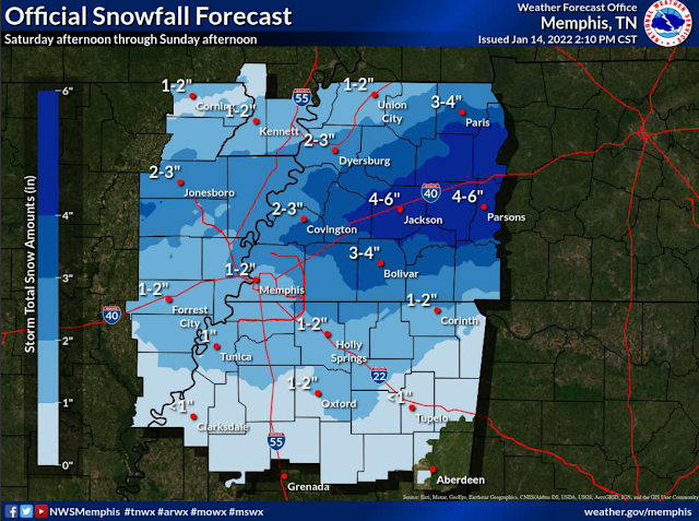 |
| The official NWS-Memphis forecast as of Friday afternoon. The area in dark blue appears to have the best chance of seeing any banding occurring, which would result in locally higher amounts than forecast. |
How about melting and a return to daily activities?
Very tough question! We really need to see how much falls first. In general, travel could be difficult to impossible Sunday, particularly on secondary/residential roads and less traveled areas. Interstates would also be problematic Sunday if multiple inches fall. Overpasses slick and dangerous. Everything freezes up Sunday night with darkness and temperatures in the 20s. Monday should see more sunshine and highs in the low to mid 40s. Expect significant improvement as the day goes on, especially on traveled roadways. Some of the snow will stick around several days in shaded areas so treat walkways and paths accordingly.
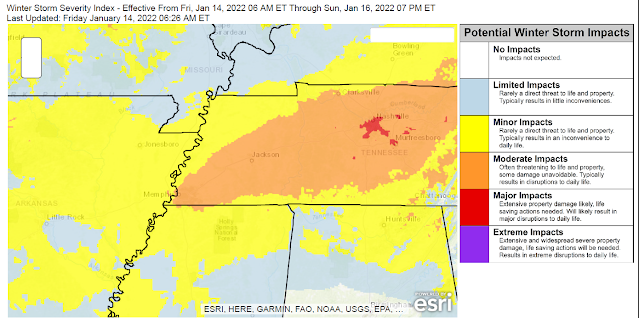 |
| The NWS Winter Storm Severity Index places southern west TN, including the immediate Memphis area, in a level 3 "Moderate Impacts" designation, with likely disruptions to daily life and possibly damaging to property in some cases. (NWS) |
Traveling in/out of the area? Also a good question. Interstates will improve the quickest and should be OK on Monday. Heaviest snow looks to be east of Memphis, so I-40 between here and Nashville is a bit of a concern. Nashville is also expecting a few inches of snow, at least. Going west or south, it likely won't be quite as bad.
Flying? In general, the airport does a great job of clearing runways (can we get their plows on the interstates?) and they have a "small cargo carrier" customer that operates on Sundays and would like to fly. That benefits passenger carriers as well. However, airlines also preemptively cancel at times when inclement weather might cause major delays. Bottom line: check with your carrier.
Summary
In sum, the gap between the "boom" and "bust" scenarios and level of uncertainty this close to an event are frustrating at best and terrifying at worst for southern forecasters who pride themselves on a certain level of accuracy. We ask you to bear with us and understand that there really are fine details that are yet to be determined that could make the difference between "what was all the fuss about" and "SN-OMG!" And honestly we may not ultimately know the exact answers until the event is about done. Here's to snow-maggedon for all who desire just "one good snow" each winter! If this doesn't pan out, know that the last half of January is trending cold...

----
Follow MWN on Facebook and Twitter for routine updates and the latest info!
Complete MWN Forecast: MemphisWeather.net on the mobile web or via the MWN mobile app
Download our iPhone or Android apps, featuring StormWatch+ severe weather alerts!
Erik Proseus
MWN Meteorologist----
Follow MWN on Facebook and Twitter for routine updates and the latest info!
Complete MWN Forecast: MemphisWeather.net on the mobile web or via the MWN mobile app
Download our iPhone or Android apps, featuring StormWatch+ severe weather alerts!
 | |
| MWN is a NOAA Weather Ready Nation Ambassador | Meteorologist Erik Proseus is an NWA Digital Seal Holder |
No comments:
Post a Comment