
Decided it would be appropriate, maybe cathartic, to sit down a put a few thoughts on electronic paper after last night's severe weather outbreak.
First, a bit of a recap. The Memphis metro was very fortunate! Monette Manor nursing home, which was devastated by the tornado that ended up traveling over 250 miles through AR, MO, TN, and KY, is 55 miles from downtown Memphis and just 35 miles from western Tipton County..
Devastating damage from Monette AR. This is the nursing home that had multiple casualties last night. #arwx @severestudios @ScottPeakeWX @weatherchannel pic.twitter.com/ROwUSQctRZ
— Jordan Hall (@JordanHallWX) December 11, 2021
That tornado would go on to destroy the town of Mayfield, KY, over 110 miles away.
This pretty much sums it up in :19. #Mayfield #MayfieldTornado #KyWx #WX pic.twitter.com/IcPL4XGtPS
— WxChasing- Brandon Clement (@bclemms) December 11, 2021
Looking at NEXRAD Doppler radar estimates of rotation, that tornado (or at least its parent storm, possibly producing multiple tornadoes) traveled over 250 miles in a few hours. If determined to be a singular tornado, it would set the record for the longest path length in recorded history. You can easily pick it out in the image of rotation tracks from last night:
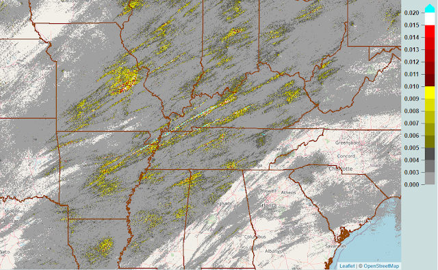 |
| MRMS radar data showing where rotation was observed Friday evening into the night. Higher values mean stronger rotation. (MRMS via the NWS) |
But if you look at that image more closely, you'll see how many areas had rotating storms pass overhead. Not all produced tornadoes, but the parent supercells were rotating aloft. There is even some rotation in the metro, particularly along and south of I-40, though more sporadic than the long-tracked events to our north. Locally, two Tornado Warnings were issued for Shelby County. One was for storm circulation that developed over West Memphis and moved into Shelby Forest towards Millington before dissipating. A second right behind it had a stronger rotation signature near the Fairgrounds and moved across the Sam Cooper area and basically along I-40/Highway 70 into northwest Fayette Co. A spotter report of a funnel cloud or brief tornado touchdown was received near the Airline Road exit at I-40 heading into Fayette Co, but so far no damage reports have been received that we are aware of.
1210am - Here is the are of concern, moving NE at 50mph. pic.twitter.com/1nfxEO6h28
— MemphisWeather.net (@memphisweather1) December 11, 2021
If you want to re-live the entire event, here are a few recap images. First, a radar loop of the entire night, from 5pm Friday to 5am Saturday.
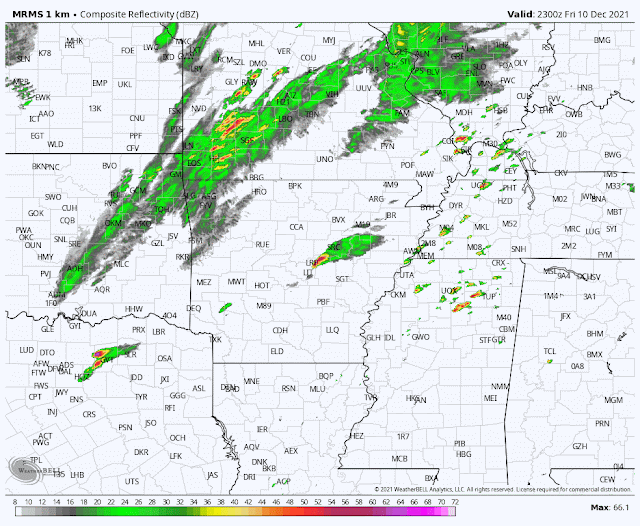 |
| Radar loop for the Mid-South from 5pm Friday to 5am Saturday (MRMS via WeatherBell) |
Here's a recap of the event from the perspective of the National Weather Service, showing their midday Friday severe weather outlook (when the Level 4 Moderate Risk was issued), preliminary severe weather reports, and Tornado Warnings issued. Honestly, it's hard to get a whole lot better than that from the perspective of the Storm Prediction Center, who issues these outlooks. They are the severe weather experts and are exceptional, particularly on the big events. We had known something was brewing as early as Monday.
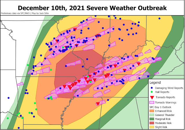 |
| Summary of NWS severe weather outlook and tornado warnings issued, with storm reports overlaid. Graphic credit: Jack Sillin |
By the way, the high-resolution computer modeling that we use to help pinpoint timing and location of threats on the day of an event did an overall remarkable job. These advances in science are saving lives by giving people like us good information to relay to you. Check out the forecast below from the HRRR, our best short-term forecast model. It is a forecast from noon yesterday showing where supercell rotation and possible tornadic activity would occur between 6pm and midnight. It basically nailed the exact path of the long-track storm that produced tornado damage from Monette to Mayfield and beyond. Simply astonishing.
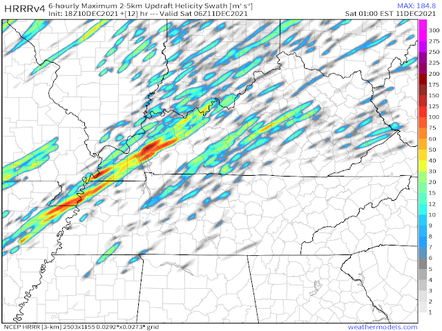 |
| The 18Z (noon Friday) HRRR model forecast showing where it believes rotating storms will occur. This image is for the period between 6pm and midnight Friday. (WeatherModels) |
A personal moment of reflection and gratitude
So, while we were very fortunate, there are others that are less so this morning. Our hearts ache for those places where destruction occurred, where lives were turned upside down in a matter of minutes.
For the elderly folks in a nursing home in Monette literally having the roof lifted from above their heads and debris raining down, and losing a fellow resident and friend in the process.
For the town of Mayfield that was nearly, literally, wiped off the map.
Bowling Green - where a Western Kentucky University student lost a relative the day before walking the stage to receive a degree.
Amazon workers near St. Louis - who witnessed the walls and roof come crumbling down under the stress of high wind.
And many others that won't make the national news, but are hurting just the same.
Amongst the destruction though, there are heroes. The headlines and news stories will laud the first responders and the doctors and nurses, all of whom indeed deserve every bit of praise for their heroic acts. They rush towards the destruction, or into medical facilities, all to serve others. And many of them are also personally affected because the storms hit the communities they serve and affect people they know directly.
But there are those who get less credit - who aren't the first ones called out by governors and mayors for their heroism and aren't named in news stories.
They are the scientists that make the jobs of those first responders less burdensome. They save lives simply through public awareness, directly resulting in fewer that need emergency assistance. They are the men and women who build the weather models, that issue the severe weather outlooks days in advance to raise awareness, that issue and communicate the forecasts locally, and then sound the alarm with severe weather warnings to prompt action to be taken by the public. The meteorologists who live in the communities they serve, and have family members at home taking cover while they go above and beyond to serve, and also heroes - on days like yesterday, and every day.
So today, I want to thank my colleagues in research, operations, and broadcast among other sectors, for their dedication to public service. They are underappreciated, and particularly after a night like last night, deserve our collective gratitude.
MWN Meteorologist
----
Follow MWN on Facebook and Twitter for routine updates and the latest info!
Complete MWN Forecast: MemphisWeather.net on the mobile web or via the MWN mobile app
Download our iPhone or Android apps, featuring StormWatch+ severe weather alerts!
 | |
| MWN is a NOAA Weather Ready Nation Ambassador | Meteorologist Erik Proseus is an NWA Digital Seal Holder |
No comments:
Post a Comment