Showing posts with label severe thunderstorms. Show all posts

Tuesday, May 7, 2024

Strong to severe storms likely Wednesday night

Another severe weather event is poised to affect a large area, including the Mid-South, on Wednesday. The area under a heightened risk includes much of the Ohio Valley, mid to lower Mississippi Valley, to as far west as Dallas.  Locally, the main threat window is Wednesday night between about 9pm-3am. (The event will not last that long, but models still disagree on exact timing. Expect storms to last for an hour or so, likely no more than two hours.)

But first, a chance the kids join you in bed tonight...

Prior to tomorrow night, scattered thunderstorms are again expected to fire up tonight along a frontal boundary that lingers over the area. As it lifts north as a warm front and the low level wind picks up overnight, storms will develop, and could be noisy. The well-known HD "HRRR" model thinks they could affect the area for multiple hours overnight. That could be overdoing it, but it might be one of those nights where the kids and pets crawl in bed with you. Fortunately, it appears the severe threat is not too high. We are in a level 1 risk in Memphis, with a few strong gusts or small hail the main threats.

A level 1 (Marginal) risk of severe weather exists tonight. (SPC)

Wednesday primes the pump for nocturnal storms

Much of Wednesday daylight hours will be dry, very muggy and warm, and windy. About what you would expect before a strong storm system in the spring! A few showers are possible, but overall the day sets the stage for the night by priming the pump with a lot of storm fuel (based on temperatures in the mid 80s and dewpoints near or above 70). The wind profile Wednesday night will also be fairly strong which will be supportive of  the maintenance of severe storms once they get going. That means high wind to 60-70 mph is possible. Also, cold air aloft will support the potential for large hail (up to 2") in any storms that tap into the unstable air and wind shear. While tornadoes are a bigger threat well to our north, the wind shear values will be supportive of rotating storms that could spawn a spin-up tornado or two. Heavy rain is also expected, perhaps 1-2".

The severe weather threat for Wednesday night, likely between 9pm-3am

After the storm

By sunrise Thursday, storms will be long gone and we will actually get some sunshine. North wind will bring in drier air, though temperatures will still make it to the low 80s. Cooler air arrives Thursday night as we drop into the 50s. Friday-Sunday will see very nice springlike conditions with sunshine, morning lows in the 50s and afternoon highs in the 70s.

Prepare now!

But first, we'll get through Wednesday night by preparing ahead of time. Garage (or carport) your vehicles tomorrow night if at all possible, secure anything outdoors that you want to keep around a while, and have multiple ways of receiving severe weather warnings while sleeping. We of course highly recommend our own StormWatch+ app, available for iOS and Android in your app store. Wake-me-up audio for Tornado and Severe Thunderstorm Warnings is included in the alert subscription.


p.s. In case you had not heard, we are rolling out a brand spanking new website on Saturday! Be sure to check MemphisWeather.net around noon for the unveiling!

Erik Proseus
MWN Meteorologist

----
Follow MWN on Facebook and Twitter for routine updates and the latest info!
Complete MWN Forecast: MemphisWeather.net on the mobile web or via the MWN mobile app
Download our iPhone or Android apps, featuring StormWatch+ severe weather alerts!
MWN is a NOAA Weather Ready Nation Ambassador Meteorologist Erik Proseus is an NWA Digital Seal Holder

Sunday, April 14, 2024

Severe weather season delivers a couple thunderstorm chances this week

We've made it into the heart of spring, which means we're also into spring severe weather season, which continues for the next month to six weeks. High temperatures in the 80+ range are 5-7 degrees above normal, so with a couple of frontal systems moving through this week, we'll need to keep an eye on the threat for strong storms. 

Tuesday

The first of those threats, and the one with the highest potential, arrives Tuesday evening. Ahead of the front, breezy south wind and an approaching upper level trough will bring high moisture levels into the region from the Gulf of Mexico. As the front approaches, thunderstorms are likely to erupt to our west and move east, reaching the area late afternoon to evening. 

The European model predicts atmospheric moisture content over the area to be near 200% of normal on Tuesday evening, more than enough to support strong to severe storms and locally heavy rain. (WeatherBell)

Strong wind at the surface (expect gusts as high as 40 mph Tuesday) and aloft, along with available storm fuel created by temperatures near 80 and dewpoints in the mid 60s, should allow the storms to be strong to severe, especially in areas near and west of the river, including the metro. For now, a Level 2 (Slight) risk of severe weather is forecast for this area, but will probably be tweaked a bit in the next 48 hours. The primary threat will be damaging wind, but a couple of tornadoes can't be ruled out. The threat should end before midnight as it currently stands. Stay in touch the next couple days.


Thursday

Looking beyond Tuesday night's front, the atmosphere won't cool off much and moisture levels return to high levels by Thursday as the next front heads our way. The severe threat appears lower with this front, despite it being more potent in terms of trailing cool air, as there will not be the dynamics created by strong low pressure accompanying it. It's still several days out, so we'll keep an eye on it for any changes. Behind that front, much cooler air arrives for next weekend, with the potential for additional showers, as highs drop back to the 60s for a few days.

The European model simulated infrared satellite imagery shows the potential for a line of thunderstorms along a cold front on Thursday evening. (WeatherBell)

Erik Proseus
MWN Meteorologist

----
Follow MWN on Facebook and Twitter for routine updates and the latest info!
Complete MWN Forecast: MemphisWeather.net on the mobile web or via the MWN mobile app
Download our iPhone or Android apps, featuring StormWatch+ severe weather alerts!
MWN is a NOAA Weather Ready Nation Ambassador Meteorologist Erik Proseus is an NWA Digital Seal Holder

Tuesday, August 8, 2023

Details on the severe weather threat for Wednesday

As if we needed even more proof that this one of the busiest Mid-South summers for severe weather, yet another threat presents itself on Wednesday. And this one could be muti-pronged. 

This calendar for June and July shows the severe weather risk level by day for the Mid-South. 35 days in June and July presented some degree of severe weather risk. The trend is continuing into August unfortunately! (via Iowa Environmental Mesonet)

The unknown is a given...

The first thing to know about tomorrow is that there is simply a lot we do not know yet, even the night before. We are looking at the potential for multiple rounds of thunderstorms crossing the Mid-South, but believe there will be two main "windows" for severe weather. However, within those, multiple storms are possible. 

One of the reasons for the uncertainty is that each wave could have an effect on what happens in its wake. If predicted storms do not materialize, or are brief, it could keep open the possibility of the next one being a bit stronger. However, if a larger complex of storms were to move through early, then it could stabilize the atmosphere in its wake and result in a weaker round later. 


...but honestly it is, Mitch. So let's talk about what we know and what we think we know.

What we know

The Storm Prediction Center believes that the threat of damaging wind is high enough (as of Tuesday evening) between 7am Wednesday and 7am Thursday to include areas roughly north of the TN/MS line in an Enhanced Risk of severe weather, level 3 out of 5. Areas south of the state line are in a Slight Risk (level 2). 


Damaging wind is the main threat with any storms that move through tomorrow. Yes, again. By now you know how to prepare for that - secure it, stow it, and charge it. Heavy rain and lightning are also likely, probably multiple times. If storms move over an area repeatedly, flash flooding could result. It's not likely from a single storm, but a couple back-to-back could overwhelm storm drains or small creeks and tributaries. Secondary threats, which are not as likely but also cannot be ruled out, include hail and an isolated tornado. Tornadoes in August?? Do I have to remind you this is not your typical summer? Yes, it is in the realm of possibility that the strongest storms could be capable of spinning one up. Not likely, but not zero chance.

The probability of severe wind (58+ mph) occurring within 25 miles of Memphis is about 30%. (SPC)

The probability of a tornado occurring within 25 miles of Memphis is about 5%. (SPC)

What we think we (might) know

There will likely be multiple windows when storms are expected, but the two main ones appear to be mid-morning through early afternoon and evening through the early overnight hours. In Shelby County and immediate vicinity, we think that means about 9am-2pm and about 5pm-2am. But check back again regularly tomorrow because that could, and probably will, change! 

A 24-hour forecast loop of simulated radar from the Tuesday mid-day HRRR model, starting at 7am Wednesday and ending at 7pm Thursday. Times don't matter a whole lot, because this isn't exactly right. But you can see how there are multiple waves, and the stronger storms tend to be mainly north of Memphis. Take it with a grain of salt and prepare as you should. (WeatherBell)


In addition, the potential for the strongest storms appears to be with the last wave to move through, which we think will be around midnight or shortly thereafter. That is, if the atmosphere is not so worked over that the storm fuel is tapped out. Additional showers and probably thunderstorms will be possible even after that, but we believe that by then, the severe threat will be quickly declining.

 Most of the strongest storms will probably be north of the TN/MS state line, in northern AR and west TN. Memphis sits on the southern edge of the Enhanced Risk and while there is little the high-resolution models agree on, one is that the best severe parameters currently are north of Memphis. However, again, that could change. All it takes is one butterfly to flap its wings, or one big mean supercell, to change that. And we know that a Slight Risk is not nothing. How many trees and power lines have been downed in Slight Risk or lower this summer?


How we prepare

By now, we hope that everyone has learned their lesson. It's not like we haven't seen this before, recently, multiple times. Charge devices and auxiliary power banks overnight tonight and keep them charged tomorrow. Anything outside that could lift-off without so much as a countdown clock should be tied down or brought in. That might include Fifi the poodle, and it certainly includes lawn furniture, patio cushions, etc. If you have a place to park under cover, use it. Program whatever devices you use for severe weather notifications as well.


And of course stay plugged in, not just to your outlets, but to your no-hype weather peeps. They'll keep you sane and informed. If storms move through and the sun comes right back out, expect the next round could be severe. We'll keep social media posts going regularly throughout the day starting early tomorrow morning with the latest adjustments to the forecast as needed. Be prepared, not scared.


Erik Proseus
MWN Meteorologist

----
Follow MWN on Facebook and Twitter for routine updates and the latest info!
Complete MWN Forecast: MemphisWeather.net on the mobile web or via the MWN mobile app
Download our iPhone or Android apps, featuring StormWatch+ severe weather alerts!
MWN is a NOAA Weather Ready Nation Ambassador Meteorologist Erik Proseus is an NWA Digital Seal Holder

Thursday, April 6, 2023

Recap of the March 31, 2023 tornado outbreak in the Memphis area

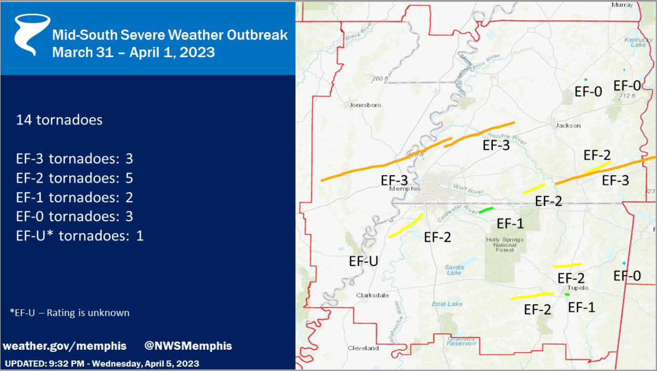
A severe weather outbreak, producing multiple strong tornadoes from a small handful of supercell thunderstorms, affected the Memphis region on the evening of March 31-April 1. A total of 14 tornadoes touched down in the Memphis County Warning Area (CWA), which encompasses west TN, northeast AR, the Missouri bootheel, and north Mississippi. Three of these tornadoes were rated EF-3 and another five were EF-2. The graphic below summarizes their tracks.


Within the eight-county Memphis metropolitan area covered by MemphisWeather.net (MWN), there were four tornado paths. Detail on each of these is summarized below. More detailed information from NWS-Memphis on all 14 tornadoes can be found here.  


Cross/Crittenden/Tipton County Tornado

Rating:                 EF-3
Est. Peak Wind:   150 mph
Path Length:        73.00 miles
Path Width (max):   1600 yards (0.91 miles)
Fatalities:             4
Injuries:               26
Start Time:           4:30pm
End Time:            5:54pm
Approx. Speed:    52 mph


Summary:
The "Wynne Tornado" touched down in western Cross County, AR at 4:30pm, spawned by the same supercell thunderstorm that resulted in tornado damage in North Little Rock earlier. The storm moved quickly east-northeast across Wynne with EF-3 strength, ravaging Wynne High School and destroying multiple residences. Slightly weaker, it passed north of Earle, AR (Crittenden Co) and crossed farmland before regaining EF-3 strength as it crossed Corna Lake in far western Tipton Co (west of the Mississippi River) before crossing the river and producing EF-2 damage in Wilder Farms (Tipton Co), eventually lifting near Burlison.


Tipton/Haywood County Tornado

Rating:                 EF-3
Est. Peak Wind:   150 mph
Path Length:        39.53 miles
Path Width (max):   2000 yards (1.14 miles)
Fatalities:             1
Injuries:               28
Start Time:           5:48pm
End Time:            6:29pm
Approx. Speed:   58 mph


Summary:
The "Covington Tornado" originated from the same supercell thunderstorm as the Wynne tornado, and touched down six minutes before the Wynne tornado lifted, meaning the supercell produced twin tornadoes for that six-minute period over Tipton Co. This tornado touched down at 5:48pm just northwest of Munford and moved quickly northeast while increasing in strength as it approached Highway 51 south of Covington. Several homes and businesses were completely destroyed and many more were significantly damaged. Fifty-three power poles had to be replaced along Highway 51 south of Covington. The elementary and middle schools sustained heavy damage, as did additional homes along Highway 54. A couple of large metal power poles were bent to the ground as the tornado widened to a mile in width as it moved across rural area east of Covington. It continued east-northeast across farmland and Hatchie River wetland before weakening and eventually lifting north of Brownsville in Haywood Co. 


Tunica/DeSoto County Tornado

Rating:                 EF-2
Est. Peak Wind:   130 mph
Path Length:        22.87 miles
Path Width (max):   1200 yards (0.68 miles)
Fatalities:             0
Injuries:               0
Start Time:           7:31pm
End Time:            8:02pm
Approx. Speed:   47 mph


Summary:
The "Prichard-Nesbit Tornado" touched down just northeast of the Tunica airport, moving northeast, mainly through rural areas of Tunica and DeSoto Co. Snapped and uprooted trees were observed in Tunica and southwest Desoto county.  Roof damage occurred after passing thru the Arkabutla bottom, with extensive tree damage and damaged or destroyed homes noted west of Highway 301.  Between Baldwin & Fogg Rd there was EF-2 damage and the tornado dissipated southwest of Nesbit.


Marshall County Tornado

Rating:                 EF-1
Est. Peak Wind:   95 mph
Path Length:        8.13 miles
Path Width (max):  100 yards
Fatalities:             0
Injuries:               0
Start Time:           8:27 pm
End Time:            8:37 pm
Approx. Speed:   50 mph


Summary:
An EF-1 tornado touched down in Marshall county west of Highway 311, moving northeast before dissipating about ten minutes later northeast of Slayden. Primary damage was to hardwood trees that were snapped or uprooted, while one home also sustained roof damage.

Shelby County Damaging Wind

Finally, MWN surveyed the Sea Isle area of southeast Memphis, near I-240 and Mt. Moriah Road leading into the area of Quince and Estate, as well as American Way between Getwell and Mt. Moriah Roads. Over this large area, many mature hardwood trees were uprooted or had large branches snapped by strong wind. Trees were observed to have fallen on houses, vehicles, and power lines/poles, resulting in additional damage and thousands of customers without power. Near American Way and Getwell, a high-voltage transmission tower was bent over (though a photo of the tower prior to the storm suggested that it may have had preexisting damage that had weakened the structure). In addition, there were three fatalities, including two children, due to a tree falling on their home on South Edgewater Road in the area of Memphis International Airport.

Given the scattered nature of the damage and no "ground path" observed, the damage was due to straight-line wind on the edge of a strong supercell that moved by just to the east of this area into Germantown. The National Weather Service and NEXRAD radar corroborates that this damage was caused by up to 85 mph wind generated by the "forward flank downdraft" of the supercell.

Erik Proseus
MWN Meteorologist

----
Follow MWN on Facebook and Twitter for routine updates and the latest info!
Complete MWN Forecast: MemphisWeather.net on the mobile web or via the MWN mobile app
Download our iPhone or Android apps, featuring StormWatch+ severe weather alerts!
MWN is a NOAA Weather Ready Nation Ambassador Meteorologist Erik Proseus is an NWA Digital Seal Holder

Tuesday, April 4, 2023

A windy and stormy Wednesday ahead - details on potential threats

After severe storms have battered the Southeast for the past two weeks, we unfortunately have another severe risk this week. Today, we will warm up into the mid-80s with mostly cloudy skies as the warm sector takes over. The severe threat today clips the metro, but will stay to the northwest mostly, with our threat moving in tomorrow. After last Friday's severe weather, any preparations need to be made ahead of time, especially for areas impacted by the last storm system. The worst of this system appears to be well north of the Mid-South, but we are still in a heightened severe weather risk zone.

Overview

A strong storm system is going to be moving across the country, causing severe weather to impact millions from the Great Lakes to the Gulf Coast. Most of the northern metro is under an Enhanced Risk (Level 3/5) Wednesday with the southern half mostly in a Slight Risk (Level 2/5). This can still change as we get closer to the event. This means that severe weather is possible to likely in the area, but that does not necessarily mean your exact town will see severe weather. The timeframe for our biggest concern is looking to be early afternoon into the evening, with more specific timing as we get closer to the event. Some pop-up showers and storms are possible ahead of the main threat too, which could play a factor into the instability, or the storm fuel that is required to produce severe weather.


Tornado Threat

The Enhanced and Slight risks can be broken down into threat by severe weather type, including tornadoes, damaging winds, and hail. Starting with the tornado threat, compared to the last few events the threat for tornadoes is lower than last week, but still present. Our area lies between the 2% and 5% risk for tornadoes, meaning that the threat for tornadoes is low, but one could still spin up with any storms that become severe. Any showers and storms during the day before the main threat could keep instability in check, which could help limit the threat.

Tornado risk for Wednesday (NOAA/SPC)

Damaging Wind Threat

While the tornado threat is in the lower side, this is looking to be more of a damaging wind threat for our area. Outside of storms, we could see gusts above 30 mph during the day with higher winds aloft. The metro lies mostly in the 30% risk area, which is the chance of seeing 60+ mph winds within a 25 mile radius of a location. The southern half of the metro lies within a 15% risk area. Any storm that becomes severe will be capable of damaging winds as broken storms move arrive during the afternoon and more of a squall line in the early evening hours. Power outages and wind damage will be possible so make sure any loose objects are to up and secure.

Damaging wind risk for Wednesday (NOAA/SPC)

Hail Threat

Most storms that become severe do have hail potential, and so we do have a hail risk for tomorrow's event. Our hail threat is not as high as northern states impacted by this same event, but we do have a 15% chance of hail within 25 miles of a location. Along with a hail threat, we also have a threat for minor flooding during the afternoon and evening as 1-3” of rain is possible. Avoid low-lying areas and roadways and do not drive through flooded areas.

Hail risk for Wednesday (NOAA/SPC)

Summary

Timing: early afternoon into the mid-evening
Overall threat: Enhanced (level 3/5) (west TN, northeast AR) to Slight (level 2/5) (north MS)
Tornado risk: 2-5% within 25 miles
Wind risk: 30% within 25 miles
Hail risk: 15% within 25 miles

Preparation

Use today and Wednesday morning to prepare for potential severe weather. That includes being ready to use your safe place if necessary, having outdoor items secured, and having multiple ways of receiving weather warnings, including LOCAL TV/radio, NOAA Weather Radio, Wireless Emergency Alerts on your phone, and a reliable weather warning app, such as StormWatch+ that is programmed ahead of time.

Kailah Gordon
MWN Intern

----
Follow MWN on Facebook and Twitter for routine updates and the latest info!
Complete MWN Forecast: MemphisWeather.net on the mobile web or via the MWN mobile app
Download our iPhone or Android apps, featuring StormWatch+ severe weather alerts!
MWN is a NOAA Weather Ready Nation Ambassador Meteorologist Erik Proseus is an NWA Digital Seal Holder

Thursday, March 30, 2023

Another Friday night, another elevated severe weather threat...

One week ago - last Thursday - we were preparing for a Friday night special, a Moderate Risk zone that extended from Memphis into Mississippi. While Memphis escaped the worst of that system, many in north Mississippi cannot say the same. It's Thursday again, and like last week, another severe weather event is lining up for Friday night. This time it appears to be aiming a bit further north. While no two weather events are alike (and this one is a different scenario than last week), it does serve to remind us that we are now into the grips of "The Pollening" season, a.k.a. spring severe weather season. So let's chat about tomorrow night.

Overview of Friday's severe weather threat

The potential for severe weather tomorrow night has been monitored by the Storm Prediction Center and local meteorologists since Monday. As of today, the event has come into better focus and the more general global models have "handed off" the details to the higher resolution models that provide additional clarity. The risk level has accordingly increased to the point where the Memphis metro is now in a level 4 (of 5) Moderate Risk for severe weather. This means that severe weather somewhere in the area is likely, not necessarily in your neighborhood, but probably within the greater metro somewhere. The timeframe of most concern for big storms is 4pm-midnight Friday. A few thunderstorms of the more general variety, and more than likely some showers, are possible during the day. These may play a role in the ultimate outcome in the evening in fact.


Tornado threat

The Moderate Risk can be broken down by severe weather type to provide additional information on the probability of specific threats. Starting with the tornado threat, we have a 15% risk of tornadoes within 25 miles of any location in the metro. In addition, there is a 10% chance of a strong tornado (EF-2+) within 25 miles. This threat level drives the overall Moderate Risk for the event, as it is certainly elevated and worth preparing for... just in case. There will be plenty of strong wind and "spin" (or shear) in the atmosphere to support rotating storms if they can get going. However, as the Memphis NWS stated this morning in their discussion, "...this system is not a slam dunk. One potential area for failure is the presence and duration of Friday morning showers." As mentioned in the paragraph above, early-day precip could limit the storm fuel available later in the day, reducing the severe weather risk locally. This will bear watching, as it certainly contributed to a reduction in instability last Friday night north of the MS/TN state line.


Damaging wind threat

In addition to the tornado threat, the more likely scenario is a damaging wind event. As mentioned, there will be a LOT of wind energy with this system, from the surface up. Wind gusts outside of storms tomorrow afternoon and evening could easily top 40 mph and the winds aloft will also be screaming, contributing to storms moving at highway speeds once they form. The wind risk is 30%, which is the chance of 60 mph or higher wind gusts within 25 miles. In addition, there is a 10% risk of 75 or greater mph wind. I would expect that any storm will be capable of damaging wind, and it's likely that we will have a broken to solid line of storms move through in the evening hours, which could lead to widespread power outages and wind damage. If it's outside and not very secure, you risk losing it in the storms.

Hail threat

Most severe storms are capable of hail, and that risk also exists tomorrow night, though it is not as elevated of a risk as wind, at 15% chance within 25 miles. While large hail is not a major threat, it is also something to keep in mind. Rainfall for the event is also expected to be in the 1-2" range. Minor flash, urban, or stream flooding is possible during the evening hours. As always, you know to turn around and don't drown. Avoid the low-lying areas and roadways that are prone to holding water during and immediately after heavy rain.


SUMMARY
Timing: 5pm-11pm Friday
Overall Threat: Moderate Risk (level 4 of 5)
Tornado Risk: 15% (10% chance of an EF-2+) (level 4 equivalent)
Wind Risk: 30% (10% chance of 75+ mph) (level 3 equivalent)
Hail Risk: 15% (level 2 equivalent)
Flooding Risk: 15% (Slight Risk - level 2 of 4)

Preparation

Be prepared to execute your severe weather plans anytime after 5pm Friday. That includes being ready to use your safe place if necessary, having outdoor stuff secured, and having multiple ways of receiving weather warnings, including LOCAL TV/radio, NOAA Weather Radio, Wireless Emergency Alerts on your phone, and a reliable weather warning app such as StormWatch+ that is programmed ahead of time. Storms will be moving quickly so lead time could be reduced. 


Once the final line of storms moves through late in the evening, the severe weather risk ends. Fortunately it won't be too deep into the night when that occurs. We'll provide routine updates via our social media channels shown below throughout the event to keep you informed and safe!

Also, once this threat passes, know that there is another severe weather risk next Tuesday. We'll take them one at a time!

Erik Proseus
MWN Meteorologist

----
Follow MWN on Facebook and Twitter for routine updates and the latest info!
Complete MWN Forecast: MemphisWeather.net on the mobile web or via the MWN mobile app
Download our iPhone or Android apps, featuring StormWatch+ severe weather alerts!
MWN is a NOAA Weather Ready Nation Ambassador Meteorologist Erik Proseus is an NWA Digital Seal Holder

Friday, March 24, 2023

Details on severe weather threat for Friday evening (March 24)


A severe weather  outbreak is expected late this afternoon and evening across the Lower Mississippi Valley. The Memphis metro is on the northern edge of where the strongest storms will be possible. This blog post will go into the details, and is effective as of 11:30am Friday. Note that the severe weather outlook graphic (embedded in the slide above) will be updated a couple more times today. This blog will likely not. I don't expect a lot of change, and even if the "lines" on the outlook move a bit. The threats and your response should really not change.

Atmospheric setup

The setup for this event is a developing low pressure system that will move southwest to northeast across Arkansas this afternoon and evening, dragging a cold front with it. Very strong wind fields will result in plenty of energy for this system to tap into. Turning of those winds with height will mean there will also be plenty of wind shear to result in strengthening and maintenance of storms once they develop. Instability, particularly once you get north into west TN, will be a factor to watch. It will not be as high as areas to our south where better chances of tornadoes exist. All of these factors will be maximized during the evening hours (6pm-midnight or so). Let's look at the individual storm threats.

Damaging wind

This will be our main threat tonight. There is a 30% chance of severe wind (roughly 55 mph or higher) within 25 miles of you location. There is also at least a 10% chance of 75 mph wind, shown by the black hatched area in the graphic below. We WILL get a squall line that will move through the metro. That is most likely in the 8-10pm timeframe for Memphis (earlier west, later east). High wind will be likely, some gusts could reach hurricane force.


Tornadoes

Tornadoes will be a secondary threat. There are two areas these could develop. First, in supercells that form ahead of the line (after 6pm). These are most likely in MS and northern LA, but they'll move rapidly northeast, towards southwest TN. The threat for these is higher to our south, in the MS Delta, where instability is expected to be highest. Secondly, in the squall line itself, where tornadoes could "spin-up" within the line. There is more than enough shear for this to happen, and they could also be strong, but would not likely last very long. The chance of occurrence in 10% for west TN and northeast AR and 15% in the southern metro and further south. The entire area also has a 10% chance of an EF-2 or stronger tornado due to the strong wind shear expected.


Large Hail

Large hail is the least of the the three main threats. There is about a 10% chance of occurrence for all of us. Hail would be most likely in any supercells that form (again, mainly in north MS), thus there is also a 10% risk that hail could be 2" in diameter or larger in the more unstable air south of Memphis (black hatched area below).


Flash or urban flooding

There will be a LOT of water falling in a short period of time this evening. Atmospheric moisture levels are very high. So, flash flooding is possible, small creeks and streams will rise, and low-lying areas in the concrete jungle will likely become hazardous. The NWS has placed the northern half of the Mid-South in a moderate risk (3 of 4) for excessive rainfall that could lead to flash flooding, while the southern half is in a Slight Risk (2 of 4). Rainfall amounts will easily exceed an inch in a few hours, and could approach 2-3" north of I-40. Turn around, don't drown!


Limiting factors

We've had questions about whether the morning rain that dropped south to about the state line, along with a cooling north breeze and lower dewpoints, would limit the severe potential this evening. I say "probably not." 

Radar loop from 9:30am Friday, showing the rain-cooled air dropping south. The warm/moist air is poised just to the south of that area where rain fell and will move back north this afternoon.

The strong southerly wind and higher dewpoints are only a couple counties south of us. As the low forms and starts moving northeast, it will drag that warmer and more unstable air back to the north. By this evening, we'll likely be right back where we were forecast to be by the models, which leads to the setup described above. The northern areas of the metro and places north already had a slightly lower risk of severe storms, and especially supercell storms, than places to the south. That really doesn't change. So I think the current severe weather outlook from SPC (first image above) factors all of that in. It will definitely be something we watch though! If instability does not rise as expected in west TN, perhaps it will slightly limit the severe threat. Let's prepare for the worst and hope for the best though!

Prepare

It's time to finalize your plans for this evening. Be where you know you can get to shelter if need be and be ready to act quickly. Storms will be fast-moving. Expect a line of storms with high wind between about 8-10pm. Make sure stuff outside is tied down. Know the counties around you and stay weather aware so you know when it is getting close. Finally, have multiple ways to get warning information, as any one could fail in severe weather. We recommend a NOAA Weather Radio, local TV outlets, Wireless Emergency Alerts on your smartphone, and a more customizable app option, such as our StormWatch+ app for Android and iOS. Of course, keep those devices charged today! Power outages are expected tonight.


Erik Proseus
MWN Meteorologist

----
Follow MWN on Facebook and Twitter for routine updates and the latest info!
Complete MWN Forecast: MemphisWeather.net on the mobile web or via the MWN mobile app
Download our iPhone or Android apps, featuring StormWatch+ severe weather alerts!
MWN is a NOAA Weather Ready Nation Ambassador Meteorologist Erik Proseus is an NWA Digital Seal Holder