Showing posts with label snow. Show all posts

Saturday, January 13, 2024

MLK Day Winter Storm Q&A (with lots of pictures and GIFS)

I've written many a blog post ahead of winter storms over the years. The format that seems to work best is Q&A style, because I know you have questions. So herein I will try and provide answers - some to the point, some with more detail. Keep in mind this is AS OF SATURDAY MORNING. The forecast can (and probably will) change, or at least be refined. Buckle up!

Q: Is it really gonna snow?
A: Yes, really.


Q: When will it start and end?
A: Timing has been a chief concern for the past few days. Models have struggled. But they are getting better and I have higher confidence now. A Winter Storm Warning is in effect from Sunday at noon through Tuesday at 6am. I believe we could see some flurries (or maybe freezing drizzle) by late afternoon Sunday. By early to mid evening, snow becomes likely and continues much of the night and into Monday. I would expect it to taper off by mid-afternoon Monday, but flurries or light snow could linger through the evening. We're looking at 18- 24 hours of precipitation. 


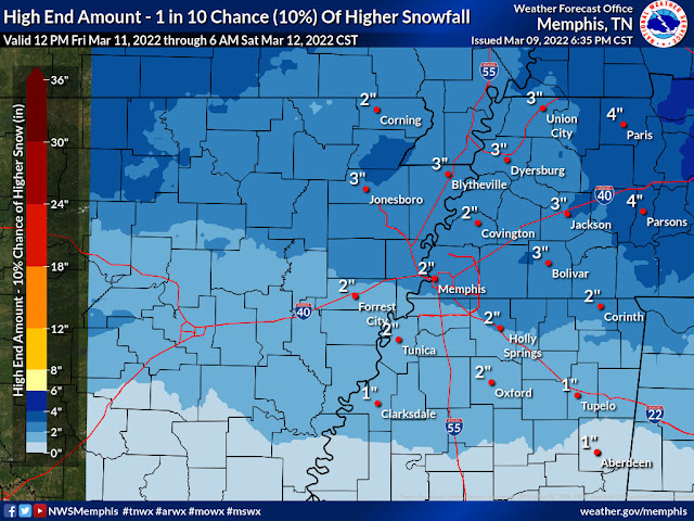
Q: How much are we going to get?
A: This is the million dollar question and the one everyone cares about. I believe Sunday night's snow will be fairly uniform and light, but still with accumulation potential. On Monday, a band (or bands) of moderate to perhaps heavy snow sets up within an area of lighter snow. This adds complication to the totals because we don't know exactly where that will happen. However, recent data suggests this could be close to or south of I-40. Within that band, there is strong potential for 5-7" of snow. Outside of that sweet spot, I still think 3-4" is going to be the average. So to put an overall range on it, 3-7" is my call as of 11am Saturday. Below is what the NWS has as of right now - we're not too different.


Q: What sort of boom and bust potential is there? 
A: Great question, glad you asked! On the low end, I think everyone in the 8-county MWN coverage area is likely to see at least 2", even if the storm underperforms. If that's all you get, you'll have to just shake it off. On the flip side, there is a low chance somewhere within a heavy band that 8" or more could fall.  


(Warning: science lesson about to break out!) Part of the uncertainty in totals has to do with what we call the "snow to liquid ratio" (SLR), which is how much snow occurs given a certain amount of precipitation in liquid form. Typically, an inch of liquid yields 10" of snow, or a 10:1 ratio. When it is very cold with lower humidity, that ratio goes up. So an inch of liquid may be 15" of snow (15:1). That type of snow is "dry" and doesn't pack well (i.e. no snowball fights and clear it with a leaf blower). I think we'll end up with a drier snow than typical for this area, but not Minneapolis dry. It's still one of the unknowns though. Sorry for the weather nerdy interruption - back to the Q&A.

Q: Any surprises, like rain or ice mixing in?
A: Doubtful. Although, there are hints that very light precipitation at onset late Sunday afternoon could be freezing drizzle. It's not a major concern for me. 

Q: How will the roads be Monday / Tuesday / in February?
A: The cold air that moves over us in the coming week is no joke. It'll be moving beyond #StupidCold to #DangerousCold for some folks. On Monday, I wouldn't recommend travel unless necessary, as we'll be in a Winter Storm Warning and there will be accumulation actively occurring. (Yes, I know the Grizzlies play a big MLK Day game. We don't need fans added to the injury list, tbh.) 


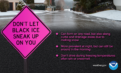
Fortunately, rain doesn't preface this event, so roads will be treated starting today and that will help. But some of those treatments don't work as well when temps get into the mid teens or colder, like they will Monday morning and definitely Tuesday morning. 


As for Tuesday, it's kind of wait and see, but if 3-4" or more falls and traffic is light Monday (likely, due to snow falling and the holiday), Tuesday morning may not be much better. The only thing that might help a little is if the snow is dusty and, with some wind blowing, main streets might fare a bit better. A hard freeze Monday night with no traffic will likely mean a dicey Tuesday morning though. Sunshine on Tuesday, despite bitterly cold temperatures could help with primary roads. I think odds are above even that Tuesday is a "snow day" though too. (That one is for you, teachers!) By February, we should be fine. 😉

Q: I have a flight...
A: Are you going to the Bahamas? Make every effort, and add a ticket for me.


So the airport is as equipped as any place to handle winter weather. They have more snow removal equipment than most southern cities and FedEx won't slow down (much). But getting there could be "tough sledding" (see questions above). The best answer is check with your airline. There will probably be cancellations, but not necessarily because the airport is "closed." It won't close. But airlines don't like getting planes stuck or crews unable to fly due to flight rules, so many times they proactively cancel.

Q: How about the #StupidCold this week? 
A: Snow is fun and generally not super dangerous. This cold will NOT be. After today, we likely won't get back above freezing until Thursday afternoon. In the meantime, temperatures will be in the teens to 20s Sunday, Monday, Tuesday and Wednesday. We'll drop into the single digits Wednesday morning. Wind chills will be dangerous, even with just a 10-15 mph wind. 

Forecast wind chills Tuesday and Wednesday mornings

Q: Will my pipes burst?
A: If your pipes have had issues when it got brutally cold just before Christmas in 2022 or in mid-February 2021, you might be at risk again. This week will be a "4-P Week." Take care of your people (and others if able), your pets (indoors or a warm place), your pipes, and your plants. Keep the faucets dripping and cabinets open on exterior walls where there are pipes.


Q: How about the electrical grid?
A:  Due to the prolonged cold, and the fact that it will affect a large area in the southeast, energy load will be well above average. I don't have to remind you of Christmas 2022 when the load ended up resulting in many issues. MLGW has already indicated that they are in much better shape than 2022, but that they will request conservation of utilities. Scattered power outages seem possible, although it won't be as bad as if ice were pulling down trees and lines. Heavy snow could cause some issues, as might excessive load. Be prepared just in case and conserve where able.


Q: What's this I am hearing about Thursday? Are we going to do this all over again??
A: I'm not talking about it just yet, other than to say "do it all over again" is not in the cards. A light winter precip event is possible, and the cold will be reinforced for a couple days behind it. Let's get through this one first.

Q: When will it be 70 degrees and sunny again?
A: March. 

Final word: This could be a dangerous storm for many in our community. While we had a little fun with this (and you probably will enjoy it especially if you have kids), please make sure you read closely the safety tips and other advice. Take care of your neighbors and be smart about your choices. Most importantly, prepare for the brutal cold. It'll be a week to ten days of well below average temperatures.

Erik Proseus
MWN Meteorologist

----
Follow MWN on Facebook and Twitter for routine updates and the latest info!
Complete MWN Forecast: MemphisWeather.net on the mobile web or via the MWN mobile app
Download our iPhone or Android apps, featuring StormWatch+ severe weather alerts!
MWN is a NOAA Weather Ready Nation Ambassador Meteorologist Erik Proseus is an NWA Digital Seal Holder

Wednesday, December 14, 2022

Perspective on the 35th anniversary of the West Memphis tornado

[ This blog post was originally posted on the 25th anniversary of the West Memphis tornado of 1987. I am resurfacing it ten years later, on the 35th anniversary, for multiple reasons. 1) It was a significant and deadly event, which could have MUCH worse had the tornado hit the dog track packed with spectators. 2) And as the first in a triplicate of major weather events in a roughly two-week span, it also sparked the flame in me that continues to burn to this day, resulting in a career in aviation weather that has been fruitful and rewarding, as well as a side business that provides another outlet to exercise my passions for weather, making a difference by keeping people safe and informed, and giving back by mentoring the next generation of successful meteorologists. Thanks for reading! /EP ]

ORIGINALLY POSTED DECEMBER 14, 2012:

A quarter-century ago, I had been living in the Memphis area for just over a year and was in middle school when an event occurred that I now believe was the first spark that started the fire, igniting a passion that lives in me to this day and likely determined my future career path.

The West Memphis Tornado of 1987

On Monday, December 14, 1987, at 9:40pm, a major twister touched down just southwest of West Memphis, AR and moved rapidly northeast at 60 mph, tearing a path through the city across the Mississippi River from it's namesake, then blew across the Mighty Mississippi (thus disproving the myth that the river and bluffs protect Memphis and Shelby County) and into Meeman-Shelby Forest State Park in northwest Shelby County before lifting just west of Millington, TN.

Track of the F-3 tornado that passed through West Memphis, AR and crossed the river into Shelby County, TN

By the time it was done, F-3 damage was recorded in both Arkansas and Tennessee along a 25-mile path, six people were dead, and 121 others were injured.  Damage estimates were approximately $35 million [1987 dollars], including 235 homes, 35 businesses (many along Broadway street in downtown), and a school in West Memphis and 88 homes in the Northaven development west of Millington that were destroyed or heavily damaged.  In all, 1,500 people, or roughly 5% of the population of West Memphis, were left homeless.

According to Associated Press archives, Arkansas Governor Bill Clinton sent in the National Guard and additional state troopers to put a halt to looting in the central business district following the tornado.

The tornado also struck several high voltage power lines, including two 500,000 volt lines and three 161,000 volt lines, leaving much of Crittenden County, AR without electric power. Those killed included a woman in her mobile home, an elderly man in a boarding house, a teenager in a grocery store parking lot, a one-year-old child in an apartment building, a person in a vehicle that was thrown on I-40, and a person in a truck stop parking lot.

As bad as it was, the destruction could have been much worse.  At the time of the tornado, 7000 spectators were at Southland Greyhound Park dog-racing track in West Memphis, which the twister missed by just one-quarter mile. Video below is courtesy KATV meteorologist Todd Yakoubian (@KATV_Weather on Twitter).


Meteorological setup

From a meteorological perspective, the tornado appeared to form just behind a warm front that lifted through the area.  From observations taken at Memphis International Airport (the closest recording station to the tornado), it was 50 degrees at 7pm with wind from the east at 6 mph and dense fog being reported. An hour later, the temperature had climbed to 66 degrees (after dark) and wind shifted to the southeast at 21 mph with fog lifting. Between 9:00-10:15pm, the temperature was 70 degrees and wind gusted from the southwest at up to 40 mph as pressure bottomed out at 29.38".

Surface map valid at 9pm with the surface low moving by just west of West Memphis.  The map indicates that it was 70 at Memphis Int'l and 40 in Jonesboro, AR with heavy snow falling in the Ozarks.

By 7am the next morning, the temperature had fallen back to 32 degrees following a night of westerly wind that gusted between 35-48 mph.  Weather maps show a potent upper-level disturbance moving by just west of the area and a rapidly-strengthening surface low moving through AR that evening.

Daily weather map for the morning of December 14, 1987. Low pressure over south TX lifted rapidly north and strengthened, reaching Chicago the next morning. The track of  the low through AR put the Mid-South in prime position for wintertime severe weather.

Upper level weather maps from December 14, 1987 at 6pm. Upper left: a strong jet stream over the Mid-South. Upper-right: an upper-level disturbance moving by to the west. Lower-left: low pressure at 5,000' over southern MO. Lower-right: surface low pressure over AR moving rapidly north, placing the Mid-South in the storm's "warm sector."

A triple case of bad luck

Unfortunately, the tornado was just the first event in a series of cases of bad luck dealt by Mother Nature. The town had not recovered from the tornado when parts of it flooded from 12" of rain eleven days later, on Christmas Eve night, leaving 1000 homes flooded and another person dead. Then, 7-10" of snow fell on January 6, another 11 days after the flooding rains. As snow melted, it added to the already existing misery caused by the flood and the destruction caused by the tornado.  Oddly enough,  West Memphis became the first U.S. city to be declared a federal disaster area twice in a two-week period due to this string of events.

A personal note

Many times, when a meteorologist is asked what triggered their interest in weather, it is a singular event that had an impact on their life. For many years, I was unsure of what that event in my life was.  However, I knew that my passion began in the middle school years, shortly after I relocated with my family to the Memphis area. There is no doubt now though, as I now vividly recall the destruction of the city upon driving through it with my parents within a few days of the tornado, that the West Memphis tornado of 1987 was THAT event in my life. I find it hard to believe that it was 25 years ago!  Perhaps that is also why I am so passionate about making sure people are informed and taking precautions when severe weather strikes, which has resulted in the services offered by MemphisWeather.net and our mobile app-based weather alert system - StormWatch+.

Do you have more than a passing interest in weather, even if you're not in the profession?  What event triggered your  interest?  If you've lived in the Mid-South for a quarter century, what do you recall about this event? I'd love to see your comments below!

Erik Proseus
MWN Meteorologist

--- 
Follow MWN on Facebook and Twitter for routine updates and the latest info! 
Complete MWN Forecast: MemphisWeather.net on the mobile web or via the MWN mobile app 
Download our iPhone or Android apps, featuring StormWatch+ severe weather alerts!
MWN is a NOAA Weather Ready Nation Ambassador Meteorologist Erik Proseus is an NWA Digital Seal Holder


Wednesday, March 9, 2022

Winter's last gasp... snow is in the Friday night forecast

UPDATED - 3/10/2022, 7:00PM

The snow forecast remains on track for Friday evening and as discussed in last night's post seen below. I'll skip the setup, which is discussed a bit more in the post Wednesday night and cut right to the chase.

A Winter Weather Advisory is in effect for the entire metro from 6pm Friday to 6am Saturday, which means this winter event is likely to be an inconvenience, but not necessarily a threat to life and property. 

The NWS Winter Storm Severity Index (WSSI) indicates a likelihood of minor impacts across the Memphis metro, meaning the snow could result in an inconvenience to daily life.

Rain chances increase by late afternoon with rain changing to snow from west to east around 6pm as temperatures drop from their high near 60 degrees to the mid 30s. (This is a bit earlier than mentioned last night.) We'll get a few hours of snowfall before it starts to taper off by midnight, with a few flurries sticking around into the wee hours of Saturday as temperatures continue to fall into the 20s on strong northwest wind.


Forecast radar from the mid-day run of the HRRR model, which shows snow moving through the Memphis area between about 6pm Friday and 1am Saturday. (WeatherModels)

Snowfall totals will likely be around or just above 1" in the immediate metro with potential for up up to 2" more northeast of the city and up the I-40 corridor further into west TN. This amount of snow is most likely on grass and exposed surfaces, not on roads, which should fare decently given temperatures in the mid 50s to near 60 in the early afternoon hours and early day sunshine. During the period of heaviest snow in the evening hours, some accumulation of wet snow or slush is possible on residential and secondary roads, as well as overpasses and bridges. Main roads and interstates could also get a bit of slush if the precipitation is heavy enough during the height of the event. 

The NWS forecasts about a 40-50% chance of an inch of snow, though the consensus of available model data is running about 1.0-1.5" for the event. (NWS)

You'll want to be cautious of the road conditions Saturday morning, as temperatures plummet through the 20s overnight. Despite wind that will help dry roads, slushy areas or standing water could flash freeze. Sunshine and temperatures in the mid 30s will be very chilly Saturday, but it will be enough to take care of any slick spots on the roads.

Stay with us on social media throughout the event for the latest conditions and last minute updates! Links are at the bottom of this post or use the free MWN app to follow our social channels.


ORIGINAL POST - 3/9/2022, 8:00PM

Just when you thought winter was over....
Last week's beautiful weather gave way to a chilly and damp day Monday, but the sun shone again today and temperatures are warming with more sunshine tomorrow as highs reach the lower 60s. Friday will start off like a decent spring day with sunshine and decent temperatures again... but what's lurking just over the horizon is "Third Winter," which will last for about 48 hours. We can then begin another warm-up and "The Pollening" as we head into real spring! Tonight's blog will focus specifically on those 48 hours, and really mainly the first 6-12 of them... and boy will they be eventful! 

Friday overview

After reaching about 60 degrees on Friday, a cold front will move through the Mid-South. You'll note a wind shift to the northwest and gusty wind as skies cloud up. Temperatures drop very quickly behind the front - falling through the 50s in the afternoon, and then the 40s and 30s in the evening. Initial rainfall that starts by early evening is likely to change quickly over to snow, most likely by around 9pm. Snow could be steady to maybe even heavy at times for a couple of hours before tapering off as quickly as it arrived, shortly after midnight. The 10pm to midnight timeframe is our best educated guess at when the steadiest accumulating snow will fall.  If you are heading to the Grizzlies game that evening, it could look like a snow globe outside after the streamers fall inside.


After the snow...

Temperatures will continue to fall on gusty wind and bottom out Saturday morning in the low to mid 20s. The sun will be back out Saturday, but cold air pouring in from the northwest on gusty wind will likely keep the mercury from reaching 40 degrees Saturday afternoon. (And in mid-March, with full sunshine, it's pretty hard to stay below 40!) Another cold night is in store Saturday night with lows in the mid 20s once again, but we'll start to moderate during the day with continued sunshine and high pressure moving to our east, allowing southerly wind to warm us into the upper 50s. 

So let's answer some questions about our brief visit from "Third Winter"

Q: How much snow will we get? Any ice?
A: If it weren't falling on warm roads and ground, it might amount to a couple of inches. Instead, roads are probably going to survive pretty well as most of the snow melts on contact. Grass/mulch/bare ground and exposed objects could see an inch of snow cover, perhaps more north of the Bluff City, and likely less in north MS. The cold air arrives so quickly (near the ground and aloft) that ice is not expected.

Forecast snow totals for Friday evening from the NWS (as of Wednesday afternoon)


Q: What is the confidence factor in this event?
A: We're still a couple days out, but models are pretty well in alignment, and all have been poking at this event for a few days now. Confidence is high that we'll see snow and the overall timing (primarily 9pm-midnight), and medium in the amounts. I'm a bit less confident it what it will look like Saturday morning when we wake up.

"Boom" forecast for Friday evening from the NWS (as of Wednesday afternoon). These amounts have a 10% chance of occurrence and are considered a "reasonable worst case."


Q: What about freezing overnight with lows well down into the 20s?
A: That is one of my biggest questions marks. I expect that most roads will be fine. There will be lots of wind and cold but dry air once the system departs Friday night. Some areas that get puddles before the snow starts could "flash freeze" overnight as the temperature drops so quickly. If you will be out early Saturday morning, watch for pockets or patches of ice. I would not cancel any travel plans Saturday if you are headed somewhere warmer (and I also won't blame you!).


Q: Why, Erik?? It's spring break weekend!
A: I know right? I'm in sales not production, and there are times the family goes hungry... 

It's honestly not completely unusual to get a "last gasp" of winter, including snowfall, in early March. This is a bit late, but the latest recorded inch of snow is March 29. And despite the fact that any measurable accumulation on Friday will set a snowfall record for the date, there are actually four events on record that occurred later in March that dropped more than 4 inches. FOUR INCHES! So while it might be rare, it's certainly not unprecedented. So let's get it over with and move on to...


Monitor our social media feeds for the latest information and any changes between now and Friday night. 

Erik Proseus
MWN Meteorologist

----
Follow MWN on Facebook and Twitter for routine updates and the latest info!
Complete MWN Forecast: MemphisWeather.net on the mobile web or via the MWN mobile app
Download our iPhone or Android apps, featuring StormWatch+ severe weather alerts!
MWN is a NOAA Weather Ready Nation Ambassador Meteorologist Erik Proseus is an NWA Digital Seal Holder


Sunday, January 16, 2022

Wrapping up the January 16, 2022 snow event

Well, that was fun! 

That is one way to describe about 3 days on non-stop hand-wringing over one of the most challenging winter weather forecasts this meteorologist has encountered in 25 years of forecasting the Memphis area. Friday's blog described the scenario - one in which a rare atmospheric setup resulted in an upper level low taking a giant hook over the southern Plains towards the area and merging with surface low pressure over the Deep South. Even our most reliable medium-range global models and short-term high-resolution models struggled with consistency and output, with wild swings in potential snow amounts for the area. Add in the potential for "banding" of snow in small areas due to the power of the upper low, and you end up with a very challenging event.

In the end, on Friday I decided on rain changing to snow near or after midnight, potential heavy in the early morning hours, tapering in the hours after sunrise, and "generally 1-4 inches with the greatest probability of the higher amounts east of Memphis." I also said in the blog "localized bands could produce up to 4-6" of snow." And with a little bit of luck, that verified pretty well if I do say so myself. 

How it started: How it ended:
 
A preliminary listing of snowfall totals from across the Mid-South can be found here.

Overall, 1-2" is what the immediate metro received with lower amounts closer to the river and higher amounts in eastern rural areas. Going further east, areas near the TN/MS state line east of the metro saw isolated amounts of up to 5-9"! The amounts in the city were slightly reduced by the "wetness" of the snow that fell. Typically, snow in the Mid-South has about an 8:1 to 10:1 snow ratio, meaning that for each 0.10" of liquid water that falls, about 3/4"-1" of snow can be expected. Because temperatures were just above freezing, relative humidity was above 90% and the amount of moisture above us was high, the snow ratio for this system ended up being closer to 5:1. That reduces potential snow totals by up to one-half of what would fall with snow that isn't so wet. We knew it would be a wet snow, but not quite THAT wet! 

In addition we also saw that where snow came down hard (like in the video above where snow-globs were more than an inch in diameter as they fell), even with temperatures above freezing, the roads can coat pretty quickly. The fact that temperatures didn't get below freezing by much, or for long, meant that they also melted fairly quickly once the sun rose and snow ended.

There were scattered power outages in the Memphis area and, tragically, one woman lost her life while driving a vehicle when a snow and ice laden tree fell over and landed on her car in southeast Memphis. But overall, it ended up being a manageable event for most.

Hopefully you were pleased with what you ended up getting today! Given the MLK Day holiday tomorrow, I expect no issues at all when work and school start back on Tuesday. If you are out early tomorrow though, you will want to keep an eye out for a little black ice in spots where melting occurred and left water on the roads tonight. Hopefully we don't have any more of those types of events again for a long while!actio

Erik Proseus
MWN Meteorologist

----
Follow MWN on Facebook and Twitter for routine updates and the latest info!
Complete MWN Forecast: MemphisWeather.net on the mobile web or via the MWN mobile app
Download our iPhone or Android apps, featuring StormWatch+ severe weather alerts!
MWN is a NOAA Weather Ready Nation Ambassador Meteorologist Erik Proseus is an NWA Digital Seal Holder

Saturday, February 20, 2021

Temperatures and snowfall records set during the recent Arctic Outbreak

Now that we are back above freezing (at least during the day) and the #StupidCold Arctic Outbreak is receding, we can look back and see, statistically, just how cold and snowy it was. The following temperature and snowfall records are now in the books:
  • Coldest high temperature: February 14 (19°)
  • Coldest low temperature: February 15 (9°)
  • Coldest high temperature: February 15 (15°)
  • Coldest low temperatures: February 16 (1°)
  • Tied coldest high temperature: February 16 (18°)
  • Coldest low temperature: February 20 (9°)
  • Daily record snowfall: February 15 (4.0")
  • Daily record snowfall: February 17 (4.7")
  • Fourth snowiest four-day period: February 14-17 (10.0")
  • Tied for second - consecutive days with high temperatures less than 20° (February 14-16)
  • Tied for longest consecutive streak of days with high temperatures less than 32° (February 11-19)
  • The average temperature for the period February 11-19 was 19.8° - the coldest for that nine day stretch on record.
All data is recorded at Memphis International Airport, the official observation site for Memphis, TN.

Estimated snowfall over the past week. Graphic courtesy NWS-Memphis.

Average temperature anomaly (departure from normal) for the week of February 12-19, 2021. Data provided by the NOAA/NCEP Climate Data Assimilation System (CDAS). And yes, the cold across the central portion of the country appears to be "off the charts!" (WxBell)


Erik Proseus
MWN Meteorologist

----
Follow MWN on Facebook and Twitter for routine updates and the latest info!
Complete MWN Forecast: MemphisWeather.net on the mobile web or via the MWN mobile app
Download our iPhone or Android apps, featuring StormWatch+ severe weather alerts!
MWN is a NOAA Weather Ready Nation Ambassador Meteorologist Erik Proseus is an NWA Digital Seal Holder

Saturday, February 13, 2021

Winter Storm Warning for the Memphis metro


A Winter Storm Warning has been issued from noon Sunday through midnight Monday night. In addition, a Wind Chill Advisory has been issued for tonight.

Timeline

Spotty areas of sleet, freezing rain, or snow are possible during the day Sunday. However, most precipitation begins by late afternoon, likely as sleet possibly mixed with some snow, and continue through the early overnight hours. A lull in precipitation is possible during the early morning hours before precipitation picks back up again Monday morning. Snow is expected Monday with some sleet possibly mixed in during the morning hours. The heaviest snow is expected from mid-morning to mid-afternoon before tapering off to flurries late afternoon into the evening. 

Accumulation

Up to 0.5-1.0” of sleet is expected, while 4-6” of snow is expected to top the sleet and lingering ice from Thursday’s storm.

Impacts

Travel will likely become very challenging to impossible by Sunday night. With bitterly cold temperatures and dangerous wind chills also expected (lower single digits tonight and again Sunday night through Monday), the remnants of the storm are likely to linger well into next week, when another winter storm is expected Wednesday into Thursday.


More details on this third system are yet to come, but it has the potential to also be a significant storm. Details on the forecast can be found in the MWN app and here.

Erik Proseus
MWN Meteorologist

----
Follow MWN on Facebook and Twitter for routine updates and the latest info!
Complete MWN Forecast: MemphisWeather.net on the mobile web or via the MWN mobile app
Download our iPhone or Android apps, featuring StormWatch+ severe weather alerts!
MWN is a NOAA Weather Ready Nation Ambassador Meteorologist Erik Proseus is an NWA Digital Seal Holder

Friday, February 12, 2021

First take on President's Day winter storm

For all of you who have been begging for winter - whether you wanted really cold temperatures, ice (why would you want that?), or a "real snow" - I hope a week from now you're satisfied. Winter has arrived and will be locked in for a good week. 

Before I get into our President's Day storm, I can't skip over the fact that it is going to get #StupidCold. Cold like we haven't seen in a couple of years and a duration  that hasn't visited the Memphis area in 20 years.  We've been below freezing since Wednesday evening and may not see 33 degrees again until mid to late next week. The last time we had five consecutive days below freezing was around New Year's 2001. 

A listing of all streaks of 5 or more calendar days in which the temperature did not rise above freezing since 1875. 2001 was the last time we reached 5. We may reach 7-9 days in this Arctic outbreak.


The current forecast low on Tuesday morning is 8 (I'm not missing a digit) with a wind chill below zero. That hasn't happened in 3 years (January 2018). Please take care of your pets, other people, and your pipes. Pipes on exterior walls can be a problem when the temperature approaches or drops below 20 degrees.


Moving on to the fun stuff... when will we get a REAL SNOW??  Monday

The general pattern

It's still a bit early, and once again we have model inconsistencies, but at 3 days out a definite pattern has emerged and now it's about nailing down the details as the storm starts coming into the range of our higher resolution models. In sum, we'll have cold air in place, low pressure tracking by well to our south, an upper level trough moving through the Mid-Mississippi Valley, and strong southwest flow bringing in the moisture aloft.

The Weather Prediction Center's thinking on the general pattern is shown below. That NWS graphic indicates the potential that more than 0.25" of liquid precipitation will fall in snow or sleet form between 6am Monday-6am Tuesday. The general ratio used for snow is 10:1 - meaning that 0.25" of liquid falling would be 2.5" of snow. For sleet, it's 3:1, which would equate to about 3/4" of sleet. We are currently right around a 50% chance of that happening, but I will tell you the model data would indicate that chance should probably be higher.

Probability of 2.5" of snow or 0.75" of sleet between 6am Monday and 6am Tuesday (NWS/WPC)

The details we can offer 3 days out

Cold air at the surface is a given - mid 20s for highs on Sunday, mid teens for lows on Monday morning, and near 20 Monday afternoon. Above us, it appears there will be a little bit of above-freezing air a few thousand feet up until Monday morning. Models indicate we could start to see some precipitation spitting down on us Sunday afternoon but slightly better chances are Sunday night. With that warm air above, I foresee sleet or a sleet/snow mix to start. By about sunrise Monday, as the stronger dynamics approach, that air aloft will cool to freezing and the stage will be set for snow. The even won't wind down until late afternoon Monday with some flurries likely lingering into Monday evening. 

The upward motion generated by the low pressure trough moving through will be quite impressive. The cold air is equally impressive. And the total atmospheric moisture will be more than sufficient as well. All good news for snow-lovers. The caveats are the track of the low which affects the temperatures aloft. If we were to be slightly warmer aloft, or for a longer period of time, we would get more sleet. If it starts colder than anticipated Sunday night, then we might start as snow earlier and the totals would be higher. 

For now though, I'm siding towards the cooler (and more reliable with the recent ice storm) GFS and NAM models. Thus, I believe we could see a thin layer of sleet covering the landscape Sunday overnight, then snow most of the day Monday. Heaviest snow is most likely from mid-morning to mid-afternoon. Snow amounts will be higher west of the river and lower east of the metro, but my early thinking is 3-5" of snow in the metro is realistic. It would not shock me if some areas see more than that. Believe it or not, the upper end of that range would put us in the top 25 snowiest days on record in Memphis.


Adjustments are likely as we get closer to the event and there will be model runs that forecast as much as a foot. If it seems too good to be true, it probably is! I am not one to knee-jerk changes to the forecast because of a single model run, but if I see trends in one direction or another, I'll adjust. Remember that wind chills during this event will be in the single digits - it will be #StupidCold.


Looking ahead, we'll probably just be recovering from the President's Day system when the next one arrives late Wednesday into Thursday. This one could be even more tricky as we'll be starting to emerge from the Arctic Outbreak, so temperatures will be crucial. Early trends are towards more freezing rain and sleet than snow, but it's a week out and we might just get some freezing rain and rain! 

More updates to come on social media. Follow our latest forecast in the MWN app or our mobile website.

Erik Proseus
MWN Meteorologist

----
Follow MWN on Facebook and Twitter for routine updates and the latest info!
Complete MWN Forecast: MemphisWeather.net on the mobile web or via the MWN mobile app
Download our iPhone or Android apps, featuring StormWatch+ severe weather alerts!
MWN is a NOAA Weather Ready Nation Ambassador Meteorologist Erik Proseus is an NWA Digital Seal Holder

Thursday, February 11, 2021

Snow sourced to a manufacturing plant? Plus a summary of today's ice storm

A dynamic winter storm system moved across the greater Memphis metropolitan area over the past 24 hours! Starting with the arrival of a light coating of ice last evening, the storm picked up steam in the wee hours Friday, arriving with a boom for many - in the form of "thunder-ice" about 4am! 


If you had "freezing rain, sleet, hail, and thunder simultaneously" on your 2021 Bingo card, congratulations! In actuality, a few strong cells did produce lightning, thunder, and in some spots small hail amongst the ongoing freezing rain in 30 degree temperatures! (And clearly, that can all happen at the same time. But you need just the right conditions, including instability riding over a cold and stable lower layer of air. Eat your heart out Jim Cantore!)


By the time precipitation tapered off mid-morning, about a quarter inch of ice accumulation was left behind, with scattered power outages and partially slickened streets, and widespread gratitude that it was not any worse. (See my Twitter feed for lots of pics of ice across the Mid-South, like the ones from @kwhoover and @LauraL311 below!)


Photo credit: @kwhoover on Twitter


Photo credit: @LauraL311 on Twitter

Later in the afternoon, as cold, damp air hung over the metro with pockets of freezing drizzle and mist in the air, some folks in Midtown started sharing their pics of steady snowfall. Looking at radar, it was clear there wasn't any widespread snowfall occurring (nor expected). However, a narrow plume of echoes was evident in a north-south orientation from the western side of north Memphis south over the western loop of I-240 and into Midtown. 

After a quick exchange with the NWS on the possible cause, it was determined that it could be coming from a factory or plant of some sort that was exhausting steam into the cold air. The introduction of a heat source and abundant moisture into an already moist and cold low level airmass could indeed result in man-made precipitation. The wind trajectory from NNE to SSW would move the saturated water molecules downwind where they would precipitate through a subfreezing airmass, resulting in snowflakes. Millions of them. 

So I quickly determined it was time to snow-chase, hooked up with my good friend and today's navigator, John, and we pointed the car towards Frayser. 


Below are a series of tweets I posted after the chase to show you visually what I saw.
So the answer is yes, man-made processes can indeed produce a change in the atmosphere that affects weather several miles away, at least in this "mesoscale meteorology" example!

For those wondering about the weather for the next week or so, we'll cover the #StupidCold temperatures and the potential for a few more winter weather events in separate blogs and our social media feeds as the crystal ball becomes clearer. In the meantime, check out forecast anytime via the MWN app (link to download below) and anytime the actual low temperature approaches 20 degrees, these tips might save you thousands of dollars:


Erik Proseus
MWN Meteorologist

----
Follow MWN on Facebook and Twitter for routine updates and the latest info!
Complete MWN Forecast: MemphisWeather.net on the mobile web or via the MWN mobile app
Download our iPhone or Android apps, featuring StormWatch+ severe weather alerts!
MWN is a NOAA Weather Ready Nation Ambassador Meteorologist Erik Proseus is an NWA Digital Seal Holder