Saturday, January 29, 2022

A rollercoaster week ahead - very warm, then winter shenanigans?

As the Memphis area goes on 10 days since our last precipitation, a full-blown blizzard / Nor'Easter / "Bomb Cyclone" (yes, that is a real term, not media-derived hype) is ravaging much of coastal New England from New York City to Maine. Snow covered the sand as far south as the beaches of South Carolina this morning, while wind gusts to 70 mph and 2-3" per hour snow rates are hitting the Atlantic beaches on Cape Cod. Eastern Massachusetts, Rhode Island, and coastal Maine will likely be measuring their snow totals with a yard stick when it's all done!
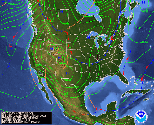
Closer to home, a reinforcing shot of cool and dry air passed through yesterday with the upper level energy responsible for that also contributing to the rapid development of the low pressure system responsible for the misery on the east coast. We have seen dewpoints (a measure of absolute moisture in the air) drop into the single digits overnight which, combined with light wind and clear skies, meant a very cold morning with lows in the mid teens outside the city and around 20 in the urban core. So there's nowhere to go but up, right?

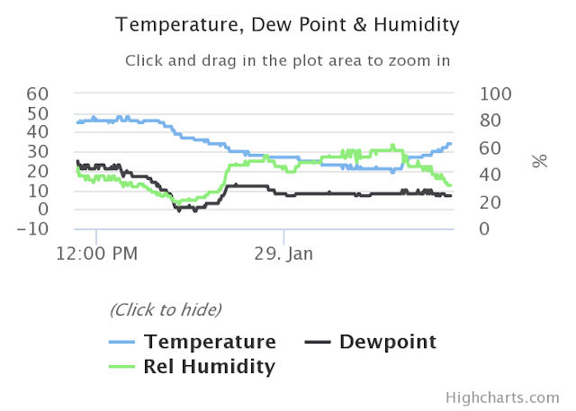
A graph of temperature, dewpoint, and relative humidity over the past 24 hours at Memphis International Airport. Check out the dewpoint (black line) bottoming out near zero last evening! (NWS)

This weekend into Monday

Sunny skies are expected throughout the weekend with surface high pressure in control and cool northwest flow aloft keeping high temperatures in the mid 40s today. However, the southerly breezy starts to work its warming magic and by Sunday we'll see highs in the upper range of the 50s, making for a very pleasant day. Overnight lows tonight stay just above freezing in the city. 

More sunshine on Monday with morning lows again near or just above freezing, but south wind helping to push those high temperatures into the mid 60s! Another beautiful day to start the week, and if you're looking for a nice day to play hooky from work this week... this is it!


Mid-week moisture return

Much of Tuesday will continue to be dry, but our upper air pattern becomes southwesterly and with southerly surface wind as well, mild temperatures are expected but clouds increase and we'll start to see rain chances tick up by early evening - the first rain in nearly 2 weeks by that point. Temperatures start in the mid 40s in the morning and rise to the mid 60s once again. 

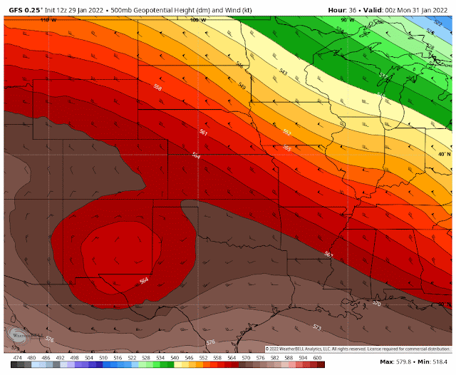
The upper level pressure pattern changes from Sunday evening (start of the loop) through Wednesday evening (end of the loop), such that wind at that level shifts from cool northwest flow to mild, and wetter, southwest flow. (GFS model via WeatherBell)

Tuesday night through Wednesday will see likely periods of rainfall and continued mild temperatures - near 50 for the low and 60+ again for Wednesday's high. Thunder is not expected and rainfall should not be particularly heavy, but showery conditions will mean a chance of a few steady downpours. If the groundhog were in Memphis Wednesday morning, it likely would predict an early spring.


Wednesday night into Thursday - shenanigans?

By Wednesday night, we'll be seeing another blast of cold air seeping south towards the region. In addition, low pressure will form Wednesday over south Texas and then move northeast, pushed by southwest flow aloft. Expect wet conditions Wednesday night, when the heaviest rainfall is most likely. By Thursday morning, precipitation totals since Tuesday evening could likely be approaching 2". 

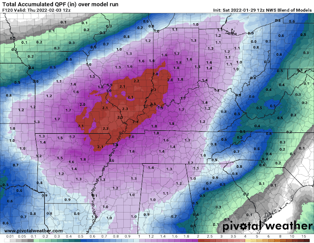
The NWS Blend of Models shows precipitation amounts through Thursday morning between 1.5-2.0" for the Mid-South.

Thursday is where my eyes are glued right now though. The key points will be:
  1. the track of the aforementioned low pressure center (which will pass by to our south across MS)
  2. the strength of that low, which affects...
  3. how quickly freezing air gets pulled south into our area behind the low, as well as...
  4. how long precipitation lingers.
The European ECMWF, American GFS, and Canadian GDPS models all have different variations on the answers to those questions, and they make a huge difference on the forecast. Early indications are that we could be very close to, if not in, an area where cold air arrives with some precipitation lingering Thursday morning. 

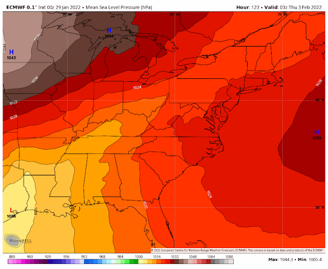
The European model shows low pressure moving out of east Texas and across north MS Wednesday night into Thursday morning, then racing northeast on strong southwest flow aloft into New England by Friday morning. (WeatherBell)

But does that mean snow? Not necessarily... With warm air aloft (thanks to those southwest winds), the cold air would likely be very shallow and near the surface. That means we could be looking at rain changing to freezing rain Thursday morning. This particular setup would mean 33° is just cold and wet, while 32° is an icy mess. 

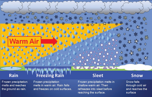
The Memphis area MAY transition from scenario 1 above (rain) to scenario 2 (freezing rain) on Thursday morning. Still lots of details to emerge though!

We're five days out, so right now the advice is "monitor the forecast and start giving through to preparations," as well as "stick with your trusted sources, not your computer mode driven weather apps." They will change on a whim, while your trusted sources will add reason to a complicated scenario. Stay tuned!

Friday into next weekend - more cold

Once the system exits sometime Thursday, another Arctic blast arrives leading into next weekend. Sunshine returns and temperatures bottom out in the teens to near 20 again Friday and Saturday mornings with highs in the 30s Friday and 40s Saturday. Beyond that, generally below average temperatures and precipitation area forecast into the week 2 portion of the forecast.

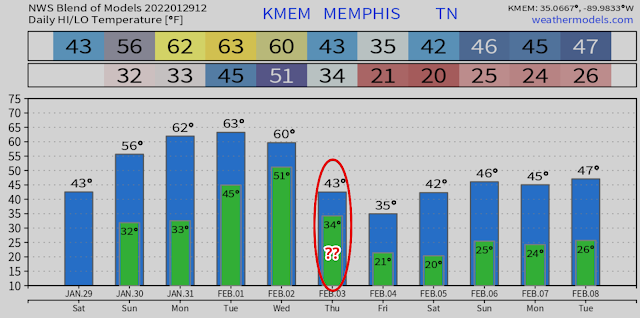
The NWS Blend of Models (NBM) from the NWS shows the roller-coaster nature of temperatures over the upcoming week, warming early in the week, then falling off the proverbial cliff by the end of the week.

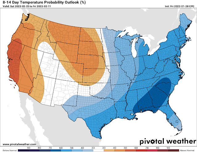
The NOAA temperature outlook for week 2 (next Saturday through Friday the 11th) shows generally below average temperatures favored for the eastern half of the country.

Erik Proseus
MWN Meteorologist

----
Follow MWN on Facebook and Twitter for routine updates and the latest info!
Complete MWN Forecast: MemphisWeather.net on the mobile web or via the MWN mobile app
Download our iPhone or Android apps, featuring StormWatch+ severe weather alerts!
MWN is a NOAA Weather Ready Nation Ambassador Meteorologist Erik Proseus is an NWA Digital Seal Holder

Monday, January 24, 2022

Wintertime returns after a brief respite from the cold

Surprise! We reached 65 degrees on Monday, which felt so good after chilly conditions much of last week and this weekend. Unfortunately, that warmth comes to an end tonight. Here's a quick look at the next several days.
 
A dry cold front will push through the area tonight, with gusty north winds and colder temperatures behind it.  Tuesday will be colder with decreasing clouds and north winds to 15 mph with higher gusts, making wind chills during the day near 30.  Lows will drop to near 20 in the city & upper teens in the outer areas Tuesday night, with wind chills in the single digits across the area.

Wind chills expected early Wednesday morning

Highs for the first half of this week will struggle to reach 40, with a slow rise to the lower 50's by the weekend.  While we will see a change in the weather, thankfully no precipitation is expected as Canadian high pressure moves in.

Another dry cold front is expected to move through Friday, bringing a halt to any warming that we gain over the latter half of the week.

Surface feature forecast for Friday morning showing another cold front approaching the Memphis area. (NOAA)

The next chance for any precipitation looks to hold off until the middle of next week (which by the way is the start of February), and looks like it will be all rain.

So be sure you're prepared for the wind & colder temps on Tuesday and Wednesday!


Richard Hoseney
MWN Meteorologist

----
Follow MWN on Facebook and Twitter for routine updates and the latest info!
Complete MWN Forecast: MemphisWeather.net on the mobile web or via the MWN mobile app
Download our iPhone or Android apps, featuring StormWatch+ severe weather alerts!
MWN is a NOAA Weather Ready Nation Ambassador Meteorologist Erik Proseus is an NWA Digital Seal Holder

Sunday, January 16, 2022

Massive South Pacific volcanic eruption sends shockwaves around the globe that were measured in Memphis

Many of you may have seen the news that an undersea volcano very near the island kingdom of Tonga in the South Pacific erupted with violent force early on Friday morning (January 15) Memphis time. The force of the explosion sent ash some 100,000 feet into the air and generated a shockwave that traveled around the world, in both directions (eastbound and westbound), from the epicenter. Satellite views of the colossal eruption are mesmerizing:

In the top two loops, you can see the "waves" emanating outward from the blast. That is the "shockwaves" that circumnavigated the globe. 

Later in the day I started seeing some tweets about changes in barometric pressure in the United States that could be traced directly to those waves propagating around the world through the upper atmosphere. 

Using timestamps from a few of those other pieces of information, I then turned to the data from my Davis Vantage Pro2 weather station, which archives all weather elements every five minutes around-the-clock. Below is that data plotted on a line graph. You can see that graph below.

The timing of the first (eastbound) wave that traveled across the Pacific Ocean and then the United States would have likely been unnoticed had I not known what time to look. But there it is, between 7:40-8:00am Friday (first red box below), represented by a slight rise in pressure, then a return to the slow fall that was in progress ahead of the winter storm that arrived Friday night.

The second wave, coming from the east, and which had traveled almost three-fourths of the way around the globe, was much more pronounced about 16 hours later. Notice the second red box below. The pressure was naturally falling towards a low around 5am as surface low pressure was passing by to our south during the winter storm. However, there was a large rise in pressure that started just after midnight and lasted about 20 minutes, followed by a major drop of nearly 0.10" of mercury in 10 minutes between 12:20-12:30am. Pressure values then returned to "normal" about 30 minutes later. So the wave that passed overhead unnoticed to all of us I am sure, lasted about an hour and included a sudden rise and then precipitous drop in pressure.


A trace of the raw barometric pressure from MWN's weather station in Bartlett recorded two pressure changes that were the result of the shockwaves emitted by the explosion of Volcano Hunga-Tonga, some 6800 miles away. The first, around 8am Friday, was relatively minor. The second, some 16 hours later or just after midnight Saturday morning, was much more noticeable to the instrumentation, if not the general public. 

Of course our prayers are with the 100,000 inhabitants of the island of Tonga in the south Pacific northeast of New Zealand, who are cut off from the world and likely dealing with significant issues from one of the largest volcanic eruptions in the modern satellite era, which allowed the rest of the world to see it in stunning detail.

Erik Proseus
MWN Meteorologist

----
Follow MWN on Facebook and Twitter for routine updates and the latest info!
Complete MWN Forecast: MemphisWeather.net on the mobile web or via the MWN mobile app
Download our iPhone or Android apps, featuring StormWatch+ severe weather alerts!
MWN is a NOAA Weather Ready Nation Ambassador Meteorologist Erik Proseus is an NWA Digital Seal Holder

Wrapping up the January 16, 2022 snow event

Well, that was fun! 

That is one way to describe about 3 days on non-stop hand-wringing over one of the most challenging winter weather forecasts this meteorologist has encountered in 25 years of forecasting the Memphis area. Friday's blog described the scenario - one in which a rare atmospheric setup resulted in an upper level low taking a giant hook over the southern Plains towards the area and merging with surface low pressure over the Deep South. Even our most reliable medium-range global models and short-term high-resolution models struggled with consistency and output, with wild swings in potential snow amounts for the area. Add in the potential for "banding" of snow in small areas due to the power of the upper low, and you end up with a very challenging event.

In the end, on Friday I decided on rain changing to snow near or after midnight, potential heavy in the early morning hours, tapering in the hours after sunrise, and "generally 1-4 inches with the greatest probability of the higher amounts east of Memphis." I also said in the blog "localized bands could produce up to 4-6" of snow." And with a little bit of luck, that verified pretty well if I do say so myself. 

How it started: How it ended:
 
A preliminary listing of snowfall totals from across the Mid-South can be found here.

Overall, 1-2" is what the immediate metro received with lower amounts closer to the river and higher amounts in eastern rural areas. Going further east, areas near the TN/MS state line east of the metro saw isolated amounts of up to 5-9"! The amounts in the city were slightly reduced by the "wetness" of the snow that fell. Typically, snow in the Mid-South has about an 8:1 to 10:1 snow ratio, meaning that for each 0.10" of liquid water that falls, about 3/4"-1" of snow can be expected. Because temperatures were just above freezing, relative humidity was above 90% and the amount of moisture above us was high, the snow ratio for this system ended up being closer to 5:1. That reduces potential snow totals by up to one-half of what would fall with snow that isn't so wet. We knew it would be a wet snow, but not quite THAT wet! 

In addition we also saw that where snow came down hard (like in the video above where snow-globs were more than an inch in diameter as they fell), even with temperatures above freezing, the roads can coat pretty quickly. The fact that temperatures didn't get below freezing by much, or for long, meant that they also melted fairly quickly once the sun rose and snow ended.

There were scattered power outages in the Memphis area and, tragically, one woman lost her life while driving a vehicle when a snow and ice laden tree fell over and landed on her car in southeast Memphis. But overall, it ended up being a manageable event for most.

Hopefully you were pleased with what you ended up getting today! Given the MLK Day holiday tomorrow, I expect no issues at all when work and school start back on Tuesday. If you are out early tomorrow though, you will want to keep an eye out for a little black ice in spots where melting occurred and left water on the roads tonight. Hopefully we don't have any more of those types of events again for a long while!actio

Erik Proseus
MWN Meteorologist

----
Follow MWN on Facebook and Twitter for routine updates and the latest info!
Complete MWN Forecast: MemphisWeather.net on the mobile web or via the MWN mobile app
Download our iPhone or Android apps, featuring StormWatch+ severe weather alerts!
MWN is a NOAA Weather Ready Nation Ambassador Meteorologist Erik Proseus is an NWA Digital Seal Holder

Friday, January 14, 2022

Friday update on our MLK weekend winter storm

Another round of winter weather is bearing down on the Mid-South, the third in the first two weeks of the new year. Winter held off until the calendar turned but, with the exception of a few nice days sprinkled in, has dominated the month of January to this point. It seems we've either had one not far in the rearview mirror, or another lurking just around the next bend since we put that 79° New Year's Day behind us!

What's causing all the fuss?

I'll start by quickly setting the stage, which hopefully will provide some context (or an excuse perhaps) for why this one is just so darn difficult to forecast. We'll need to look upstream two different directions to see how this system plays out in the big picture (but of course the devil is always in the details). First, in the upper levels, a developing trough and "ball of energy" will quickly south through the Plains over the next 24 hours, make a hard left turn, and pass just to our south before turning left again and heading up the eastern seaboard Sunday into Monday. You can see it in the animation below:

The European model shows the progression of the upper levels of the atmosphere as an upper low drops south through the Plains (counter-clockwise rotating area in yellows and oranges) and then turns east just south of Memphis while strengthening (darker reds). (WeatherBell)

Next, we lower our gaze closer to the horizon, near the surface, and watch as a low pressure system moves out of the southern Plains, across the Lower Mississippi Valley into the Deep South, then also turns up the eastern seaboard as it deepens (strengthens) quickly and becomes a Nor'Easter.

At the low levels, surface low pressure moving east over TX passes by to our south (in yellow - a favored winter path for snow occurring on the north side of it) before strengthening (greens) as it heads up the east coast. (WeatherBell)

The complicating factors in this are the paths of these two systems and their synchronizing as they band together before moving by just to our south. This is not a "typical" setup for our area, and when you throw in cold air, it complicates things. The upper level system will bring its own moisture as it dives south, but as it phases with the surface low, it taps additional moisture drawn up from the Gulf of Mexico as well. All of this sets the stage for a doozy of a winter weather system somewhere


Because of the complicated nature of the pattern, our computer models - even the best ones that specialize in the short-term - are really having an issue with producing a coherent forecast. Some details are fairly concrete; others (that probably matter most to our general readers) are still "up in the air" (literally). Let's talk through what we know and don't.

What we know (or think we do)

A Winter Storm Watch is in effect for the entire metro except Tate and Tunica Counties in Mississippi. Advisories or warnings will be hoisted soon for areas most likely to see moderate to significant disruptions to travel and commerce. 

First it's going to rain, probably a decent amount, on Saturday as the systems approach and converge and temperatures are still warm (i.e., 40s). It won't be a great day to prepare, but at least you have all day Saturday before it arrives. Those temperatures fall by late afternoon into the 30s and by late evening will reach a point where rain will start to transition to snow, starting up north and working its way south. This is likely to occur between about 9pm and midnight. A brief period of sleet or freezing rain is possible during the transition. We judge this threat to be low. Roads should continue to be fine through midnight as pavement will be warm enough to melt anything that falls. 

The European model's forecast of how precipitation will evolve from Friday evening through Monday morning as low pressure passes by to our south, wrapping moisture into the colder air on its north side (snow = blue, rain = green). (WeatherBell)

The heaviest frozen precipitation will likely occur between midnight and 7am as temperatures fall below freezing into the upper 20s, before snow tapers off as the system moves to our east. By midday Sunday, most lingering light snow will be done and we could even see some afternoon sunshine. Temperatures may rise above freezing by a few degrees in the afternoon. However, it will also be windy throughout this event - Saturday through Sunday with gusts above 30 mph possible overnight. Wind chills will be brutal.

What we don't know

The nature of a system with as much energy as this one, pivoting counter-clockwise around the area on a still TBD path, means there will be some areas that see a good deal of snow from "banding" that takes place. Typically narrow, these bands can basically vomit snow over a small area, falling at a rate that reduces visibility and makes travel treacherous, easily accumulating on paved surfaces. In other areas nearby, it may be lightly snowing with no major issues. These bands cannot be forecast much in advance, if at all, but we can define a general area where they may occur. 

These bands are what makes forecasting snow amounts so difficult in this scenario. Everyone will not get the same thing. One part of town may get twice as much as another just from one or more of these bands settings up. So the main thing we DON'T know is how much snow will fall in your backyard. Some of you will boom; others will bust. I'll get complaints and kudos from both sides. It goes with the territory.


Forecast Details

What and when: Rain changing to snow by midnight Saturday night, locally heavy through dawn, tapering Sunday morning

How much: Generally 1-4"with the greatest probability of the higher amounts east of Memphis.

Good for snowball fights and snowman building? Yes, this will be a wet snow. Always watch your blind side.

Boom scenario: Localized bands could produce up to 4-6" of snow. Given gusty wind, this could result in scattered power outages and make travel impossible.

Bust scenario: Less than an inch, if the entire system underproduces or shifts south. This scenario is possible (maybe 20%) and most likely in the case of a southerly shift in the heavy snow axis.

Temperatures: Falling below freezing after midnight Sunday morning, not rising above freezing until after noon. Low Sunday: 28°. High Sunday: 35°.

Wind chills: Mid teens Saturday night, 20s Sunday. A biting wind.

The official NWS-Memphis forecast as of Friday afternoon. The area in dark blue appears to have the best chance of seeing any banding occurring, which would result in locally higher amounts than forecast.


How about melting and a return to daily activities? 

Very tough question! We really need to see how much falls first. In general, travel could be difficult to impossible Sunday, particularly on secondary/residential roads and less traveled areas. Interstates would also be problematic Sunday if multiple inches fall. Overpasses slick and dangerous. Everything freezes up Sunday night with darkness and temperatures in the 20s. Monday should see more sunshine and highs in the low to mid 40s. Expect significant improvement as the day goes on, especially on traveled roadways. Some of the snow will stick around several days in shaded areas so treat walkways and paths accordingly. 

The NWS Winter Storm Severity Index places southern west TN, including the immediate Memphis area, in a level 3 "Moderate Impacts" designation, with likely disruptions to daily life and possibly damaging to property in some cases. (NWS)


Traveling in/out of the area? Also a good question. Interstates will improve the quickest and should be OK on Monday. Heaviest snow looks to be east of Memphis, so I-40 between here and Nashville is a bit of a concern. Nashville is also expecting a few inches of snow, at least. Going west or south, it likely won't be quite as bad.

Flying? In general, the airport does a great job of clearing runways (can we get their plows on the interstates?) and they have a "small cargo carrier" customer that operates on Sundays and would like to fly. That benefits passenger carriers as well. However, airlines also preemptively cancel at times when inclement weather might cause major delays. Bottom line: check with your carrier.

Summary 

In sum, the gap between the "boom" and "bust" scenarios and level of uncertainty this close to an event are frustrating at best and terrifying at worst for southern forecasters who pride themselves on a certain level of accuracy. We ask you to bear with us and understand that there really are fine details that are yet to be determined that could make the difference between "what was all the fuss about" and "SN-OMG!" And honestly we may not ultimately know the exact answers until the event is about done. Here's to snow-maggedon for all who desire just "one good snow" each winter! If this doesn't pan out, know that the last half of January is trending cold...


Erik Proseus
MWN Meteorologist

----
Follow MWN on Facebook and Twitter for routine updates and the latest info!
Complete MWN Forecast: MemphisWeather.net on the mobile web or via the MWN mobile app
Download our iPhone or Android apps, featuring StormWatch+ severe weather alerts!
MWN is a NOAA Weather Ready Nation Ambassador Meteorologist Erik Proseus is an NWA Digital Seal Holder

Wednesday, January 12, 2022

Another winter weather event? Looking ahead to the MLK weekend...

Barely two weeks into 2022, just removed from the warmest December in over 130 years, and we're already looking at the third winter weather event of 2022! Let's start with the wrap-up to this week first.

End of the week

High pressure that brought chilly weather early this week has scooted off to our east, so now air is wrapping clockwise around it and bringing us warmer air from our south. We'll top out near 60 degrees today with mostly sunny skies. As the high continues to move east and away from us, it opens the door to a couple of weak systems that move through Thursday and early Friday. Those systems turn our wind around to the west and then northeast. For Thursday, more sunshine and above normal temps in the upper 50s, but Friday sees more high clouds and cooler highs near 50 (still seasonal though). Lows will remain above freezing.

Progression of surface weather features across the country from Wednesday evening through Friday evening. A couple of weak troughs (brown dashed lines) move through the Mid-South Thursday otherwise dry weather is expected. Also note the major weather system diving  south from the northern plains towards the end of the loop.... (NWS)


Saturday and Sunday

A somewhat unusual track for a low pressure system that will affect the Mid-South materializes by late in the week and into Saturday. You'll notice in the loop above that a big red L (low pressure) and series of fronts dives south from the northern plains towards the region by Friday night. With an upper level trough forming over the eastern U.S., it is basically "digging" into that trough and moving south. This weekend, it merges with a low ejecting out of the southern plains into the Lower Mississippi Valley, then heads back northeast and up the eastern seaboard. A strong upper level low pressure system accompanies it, providing the lift and vigorous dynamics, while the low pulls moisture up from the south. A recipe for winter shenanigans...

So while it is too early to focus on specific details, some high level information can be gleaned from this setup, as well as what needs to come together (or not if you are a snow-hater) for winter weather to materialize. First, the ingredients for a significant snowfall somewhere in the region are becoming more apparent. Confidence is increasing that by the end of the weekend, some places in the larger Mid-South area (say southern MO, western KY, AR into west TN, or north MS) will see a fairly major snow event, given we're in Dixie - on the order of multiple inches. The unknowns are mainly "where" and "how much." 

The Winter Weather Severity Index (WSSI) forecasts where winter storm impacts are expected out to 4 days in advance. As of Wednesday afternoon, the Memphis area is in a "Minor Impacts" zone, which means we would see an "inconvenience to daily life." That could change as we get closer to the event and the area of highest impact becomes more obvious. (NWS)

We'll start the day Saturday with increasing rain chances as the low pressure drops south towards the area. It will also be cold with temperatures mainly in the upper 30s to near 40. As the upper level pressures start to fall, along with the precipitation and onset of darkness Saturday evening, the atmosphere will cool. With temperatures falling through the 30s and the low level thermal profile cooling as well, rain will likely begin changing to snow overnight and could come down steadily to heavy at times through the night. 

Again, the *where* is the true unknown right now and will depend heavily on the track of the surface and upper level low pressure systems. The northwest quadrant of the surface low, near the upper low, is typically favored for heaviest snow. If the surface low goes overhead, the heaviest snow will fall to our north. If it shifts to our south, we could be positioned in the "sweet spot." Models are spitting out some fairly impressive totals, but the location varies between models and with each model run. For now, the possibility exists for a few inches or more somewhere in the region, but may not be known until the day of the event. Lingering light snow on the backside of the system seems likely Sunday, especially early in the day, with temperatures remaining in the lower half of the 30s all day. Whatever falls likely sticks around into Monday.

The European model ensemble (in essence, the European model produced 50 times with slightly different parameters) produces these probabilities for at least one inch of snow through Sunday at 6pm. Memphis is right around 50%. (WeatherBell)

As usual, we'll have you stay in touch for more details! We'll be posting updates at least daily, especially on Facebook and Twitter, over the coming 48-72 hours. In the meantime, be a smart "sharer" of winter weather information!

Erik Proseus
MWN Meteorologist

----
Follow MWN on Facebook and Twitter for routine updates and the latest info!
Complete MWN Forecast: MemphisWeather.net on the mobile web or via the MWN mobile app
Download our iPhone or Android apps, featuring StormWatch+ severe weather alerts!
MWN is a NOAA Weather Ready Nation Ambassador Meteorologist Erik Proseus is an NWA Digital Seal Holder

Friday, January 7, 2022

December 2021 Climate Report for Memphis, TN

December Climate Recap

While November was cooler and much drier than average, December turned the tables as the majority of the country ended above normal, and the central and eastern portions finished, in most cases, warmer than the month of November. This was especially true in Memphis where the average temperature for the month was nearly 6 degrees warmer than it was in November and second warmest all-time! Multiple temperature records were broken, including the warmest Christmas Day since records began in 1875 - 77 degrees. Only four days during the month recorded below average temperatures.


As for precipitation, there was a fair amount spread throughout the month, however the month still ended nearly an inch below average, totaling just over 4.5 inches. Nearly 2 inches of that fell on the 11th though, and this was by far the most active weather day of the month, as severe storms rolled through the metro. The day will best be remembered for the violent tornadoes in northwest TN and Kentucky among other locations. That day also set a record high temperature at 80 degrees. Below are a few graphics that depict the character of the day, starting with storm reports issued by NWS offices in AR, TN, and KY. It is easy to pick out three distinct "tornado paths" from the reports, as well as all of the wind damage in the Memphis metro. A single tornado was briefly spotted in the MWN area of responsibility near Somerville in Fayette County.

Storm reports memorialized by NWS offices in AR, TN, and KY (whose jurisdiction partially extends outside those three states). Tornado reports are red icons, wind damage is orange, and flooding is green. (National Weather Service)

This image shows areas where rotation was detected by NEXRAD radars across the region. "Rotation tracks" are where storms were rotating, but not necessarily producing tornadoes. The paths of primary supercells are evident and match well with the tornado reports above. (MRMS, NWS)

Finally, thunderstorms also occurred on the 29th with minor tree damage in Shelby County. Overall, the exceptional warmth fed into multiple rounds of thunderstorms during the month and would lead to a record warm New Year's Day as well.

Memphis International Airport, Memphis, TN

Temperature 
Average temperature: 57.2 degrees (12.4 degrees above average) 
Average high temperature: 66.5 degrees (13.1 degrees above average) 
Average low temperature: 48.0 degrees (11.8 degrees above average) 
Warmest temperature: 80 degrees (10th) 
Coolest temperature: 30 degrees (20th) 
Heating Degrees Days: 258 (370 below average)
Cooling Degree Days: 25 (23 above average) 
Records set or tied Record high temperatures - 76 degrees (3rd), 80 degrees (10th), 77 degrees (25th), 74 degrees (tied-28th); record warm low temperatures - 64 degrees (10th), 64 degrees (27th), 65 degrees (28th).
Comments: Three days dropped below freezing versus an average of 11.5 days in December.

Precipitation 
Monthly total: 4.52" (0.97" below average) 
Days with measurable precipitation: 9 (1.2 days below average) 
Wettest 24-hour period: 1.87" (11th) 
Snowfall: 0.0"
Records set or tied: None
Comments: None

Miscellaneous 
Peak wind: Southwest/51 mph (10th) 
Average wind: 9.1 mph 
Average relative humidity: 71% 
Average sky cover: 61% 

 Click here for a daily statistical recap for Memphis International Airport.
 

Cirrus Weather Solutions / MemphisWeather.net, Bartlett, TN

Temperature 
Average temperature: 54.7 degrees 
Average high temperature: 64.9 degrees 
Average low temperature: 44.2 degrees 
Warmest temperature: 78.6 degrees (10th) 
Coolest temperature: 25.1 degrees (20th) 
Comments: None 

Precipitation 
Monthly total: 5.23" (automated rain gauge), 5.64"(manual CoCoRaHS rain gauge) 
Days with measurable precipitation: 8
Wettest date: 1.70" (29th) (via automated gauge) 
Snowfall: 0.0"
Comments: None

Miscellaneous 
Peak wind: Southwest/31 mph (10th)
Average relative humidity: 77% 
Average barometric pressure: 30.03 in. Hg
Comments: None

Click here for a daily statistical recap for Bartlett, TN.
 

MWN Forecast Accuracy

MWN average temperature error: 2.32 degrees 
MWN forecast temperatures within 2 degrees of actual: 66% 
MWN average dewpoint error: 2.69 degrees 
MWN forecast dewpoints within 2 degrees of actual: 59% 

MWN's forecasts extend out five periods (2.5 days, or roughly 60 hours). Historical accuracy statistics can be found here.
 

Climate Outlook - January 2022

The January climate outlook for the United States from the Climate Prediction Center is shown below. Above average temperatures are forecast for the southern U.S. into the Desert Southwest. Below average temperatures are expected across the Upper Midwest, Northern Plains, into the Pacific Northwest. Odds favor near average temperatures for Memphis over the course of the month. The average temperature for January is 42.1 degrees, which is the coldest m.


Precipitation is expected to be above normal for the northwestern U.S. and the Great Lakes south into the Tennessee Valley, while below average precipitation is forecast for the southern U.S., particularly over the Southern Plains. For Memphis, odds favor slightly above average precipitation (44%) versus a 23% chance of below average precipitation, which historically averages 4.14 inches in January.

--- 
Follow MWN on Facebook and Twitter for routine updates and the latest info! 
Complete MWN Forecast: MemphisWeather.net on the mobile web or via the MWN mobile app 
Download our iPhone or Android apps, featuring StormWatch+ severe weather alerts!
MWN is a NOAA Weather Ready Nation Ambassador Meteorologist Erik Proseus is an NWA Digital Seal Holder

Wednesday, January 5, 2022

24 hours out! What to expect from Thursday's winter weather event

** UPDATED: 12:00PM FOR ISSUANCE OF A WINTER WEATHER ADVISORY **
** UPDATED: 4:30PM FOR UPDATED OFFICIAL GRAPHICS FROM THE NWS **


ORIGINAL POST:

We're about 24 hours out from the second winter weather event of 2022. I will attempt to provide more detail to supplement what I wrote yesterday in this space, starting with a high level overview, then cutting to the chase.

Overview

Seems no winter weather event is easy to forecast in the south, but this one presents its own challenges like most. The Memphis area will basically be on the periphery of a pair of systems, one passing by to just to the north and another moving in from the south, probably merging with the one to our north once they pass us by to the east. Both are likely to have some effect on us in some way, then throw in temperatures (surface and low levels) that are transitioning from a rain profile to a snow profile (through various stages of "mix") and you have a real challenge. 

HRRR model simulated radar forecast from 10pm Wednesday through 2pm Thursday. Note the precip moving north from MS and AR and becoming freezing rain and sleet, while snow (blue) moves southeast from Missouri and merges with the southern system over the Mid-South. (WeatherBell)


What to expect

The details below are what I consider the "most likely" case for the immediate Memphis area, or near the I-40 corridor. Locations to the north (i.e. Tipton Co and points north) could see a bit more snow/sleet and less freezing rain, while northern MS (DeSoto, Tunica, Tate, Marshall) could lean more towards rain to freezing rain and less snow and sleet. 

Precipitation timing: Early morning (3-5am) until early afternoon (12-2pm)

Precipitation types: Light rain to freezing rain early, mixing with sleet around rush hour, then changing to snow by mid-morning, ending as snow flurries or freezing drizzle

Precipitation amounts: Less than 0.10" of freezing rain,  about 1/4" of sleet, less than an inch of snow

Temperature: Falling to 32 degrees by about 5-6am, then into the upper 20s before noon

Wind: North at 10-15 mph (wind chills 15-20 degrees)


What happens if...

What does it look like in boom and bust scenarios? If the system overperforms with precipitation from the south, icing would be the biggest problem. One tenth of an inch of ice would cause very slippery conditions, including on elevated roadways and overpasses and likely some power outages. If the northern branch of the two systems dips further south and temperatures are cold enough, the boom scenario would result in a bit less sleet and more than an inch of snow. Both of these scenarios have about a 10% chance of occurring. 


In the bust scenario, the northern system misses us to the north and the southern system doesn't see as much precipitation as currently expected, reducing totals of all precip types. This would result in little to no hazardous conditions from freezing rain or sleet and only snow flurries later. Again, a low probability of occurrence, though either scenario is possible.

Impacts

With initial precipitation falling in liquid form and temperatures falling to freezing early, a light glaze of ice is likely to occur on exposed objects or elevated surfaces by or during rush hour. As precipitation mixes with sleet, a coating is likely on most surfaces by mid-morning, perhaps excluding heavily traveled thoroughfares where vehicular traffic will keep road surfaces a bit warmer. With light snow falling on surfaces with a bit of ice in place, it will overlay and "stick," coating most everything. 

Plan ahead for the likelihood of some travel issues starting as early as the morning rush and continuing through the day and potentially into Friday. Temperatures Thursday night will dive into the upper teens and only climb to the mid 30s Friday with partial sunshine. You might want to plan those alternate routes that do not include high overpasses/flyovers and long stretches of elevated roadway. Here are some other safety tips:


Erik Proseus
MWN Meteorologist

----
Follow MWN on Facebook and Twitter for routine updates and the latest info!
Complete MWN Forecast: MemphisWeather.net on the mobile web or via the MWN mobile app
Download our iPhone or Android apps, featuring StormWatch+ severe weather alerts!
MWN is a NOAA Weather Ready Nation Ambassador Meteorologist Erik Proseus is an NWA Digital Seal Holder