Monday, December 27, 2021

A stormy way to end 2021, followed by a major pattern shift - to winter!

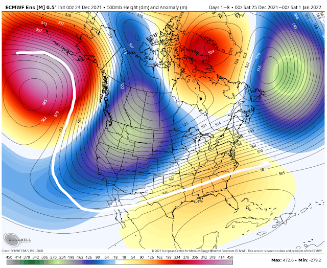
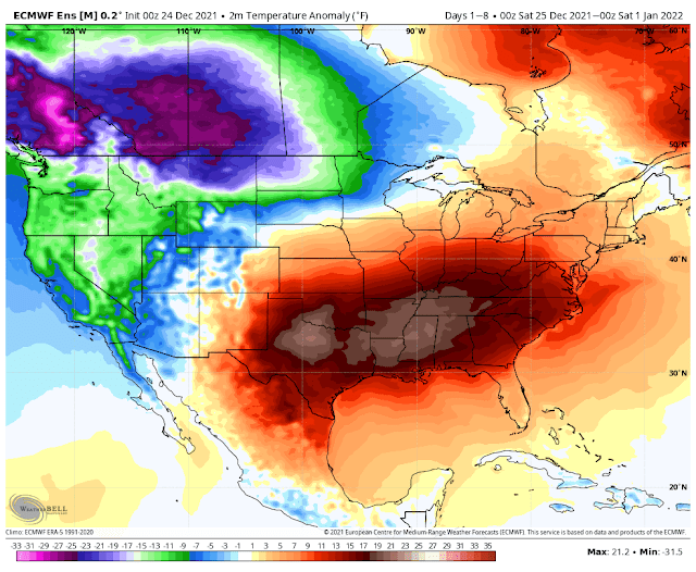
A lot going on in the weather world in the last week of 2021! There’s something in the 7 day forecast for pretty much everybody. If you love warm temps, thunderstorms, or even cold weather then you’ll find at least one day with weather you’ll enjoy over the next week. We’ll see record warm temperatures Tuesday, with a front bringing in a round of thunderstorms for Wednesday. Some could be strong, but the overall severe threat for this event is looking low at this time. We’ll stay warm, but not record breaking through New Year’s Eve. 2022 looks to start with a bang, with another round of strong storms on New Year’s Day. This is looking like a higher severe risk than Wednesday, but it’s still nearly a week away so the forecast will likely need some tweaking. After that, winter makes its triumphant arrival to the southern U.S. as the overall pattern finally looks to change going into the first full week of the new year. 

Very warm Monday night and Tuesday

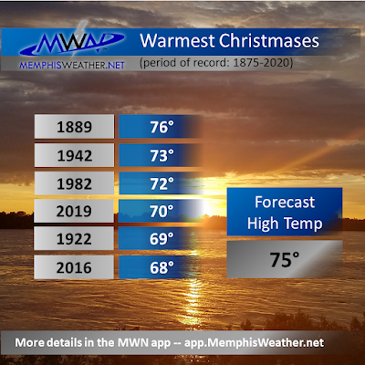
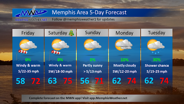
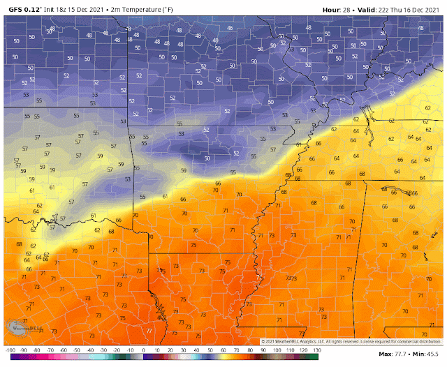
Temperatures will not fall very far at all Monday night. In fact, they will likely begin rising during the overnight hours and into Tuesday morning. With a low only in the low to mid 60s, the record warm low temperature record for December 28 (Tuesday) of 61 degrees will almost assuredly be broken. Remember, the normal HIGH temperature this time of year is around 50 degrees! A few showers will be possible through the overnight hours and to start off the day Tuesday. It will be a warm, possibly record warm day for the Mid-South. Highs will top out in the mid 70s, and we stand a good chance to beat 1984’s record high of 74 degrees. 

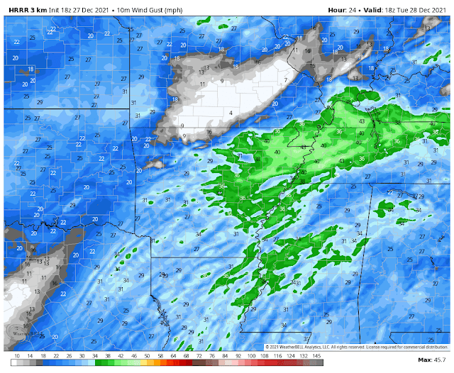
HRRR model wind gusts for Tuesday afternoon. They could be quite gusty at times, maybe 30-40 mph according to this model. (WeatherBell)

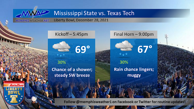
While a few showers will be possible through the day, most of us will likely stay fairly dry under overcast skies. Things are not looking too bad for the Liberty Bowl, but you may want to bring your rain jacket along with your cowbell (Hail State!) just to be safe. The bigger story may be the wind, which could be gusting well up into the 30s at times through Tuesday afternoon. Heading into Tuesday night, a couple showers will linger and winds will calm down ahead of the chance for thunderstorms on Wednesday. Temperatures will remain very mild in the low 60s.


Storms, Round 1: Wednesday

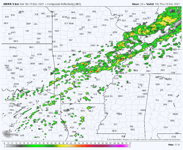
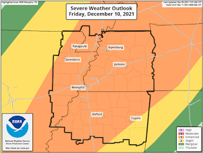
The first round of storms we will see over the upcoming week will occur on Wednesday, likely during the afternoon hours. A few could be on the stronger side with a damaging wind gust or even a tornado or two. The tornado threat is very low in the Memphis area, however, and the best severe weather risk will be to our south over Mississippi. The day will start off fairly dry, but by the early afternoon a round of storms will move through the area. Showers will linger through the rest of the day before we dry out Wednesday night. We’ll stay very warm through the day, with a high near 71.

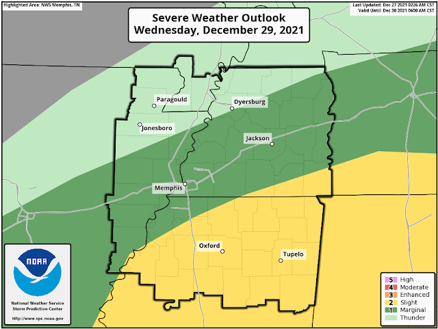
A level 1/5 risk for severe weather is in place for Wednesday across the Mid-South, with a level 2/5 risk just to our south. Overall, not looking like a major severe weather outbreak by any means. (NWS/SPC)

Thursday and New Year's Eve: a calm couple of days

A front moves through Wednesday night, but doesn’t really drop our temps a whole lot. After a wake up temp in the mid 50s, which is still very warm for the time of year, we’ll have a pleasant rest of the day Thursday with a high near 70. Skies will feature a mix of sun and clouds, and it’s looking like a great day to get outside! We "cool" down to the mid 50s again on Thursday night, with more cloud cover moving in for Friday (New Year’s Eve). The final day of 2021 is once again looking very warm, with a high in the low 70s. A few showers will enter the picture by the evening, and it’s looking warm and potentially wet by midnight when we ring in 2022, with temperatures in the 60s.

Storms, round 2: New Year's Day

The second round of storms this week comes in on New Year’s Day, especially during the daytime hours. Despite being six days out, the Storm Prediction Center has already highlighted the Mid-South and areas to the south and east for severe weather. 

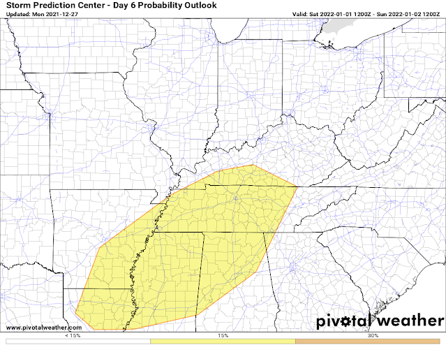
Severe weather risk for Saturday (New Year’s Day). While it is early, models are in good agreement that there will be favorable conditions for severe weather. More details will be possible as the week goes on. (NWS/SPC via Pivotal Weather)

With a powerful cold front and drastic temperature difference moving through the Southeast, this system is looking much stronger than Wednesday’s setup. At this time, I wouldn’t cancel any New Year’s Day plans, but it wouldn’t be a bad idea to have a backup plan in place should things get dicey. At this point, it is too early to nail down specific impacts. However, it is looking like the ingredients could be there to support all modes of severe weather (damaging winds, tornadoes, hail). Timing also hasn’t been nailed down yet. But a scenario exists that may actually work out in our favor: if we get rain in the early morning hours (which models show but don't agree on placement of heavy rain), then the severe risk may be reduced a bit. However, at this time it is looking like the best chance of severe weather will still be in the afternoon as the front approaches. Again, details to come and stay tuned!

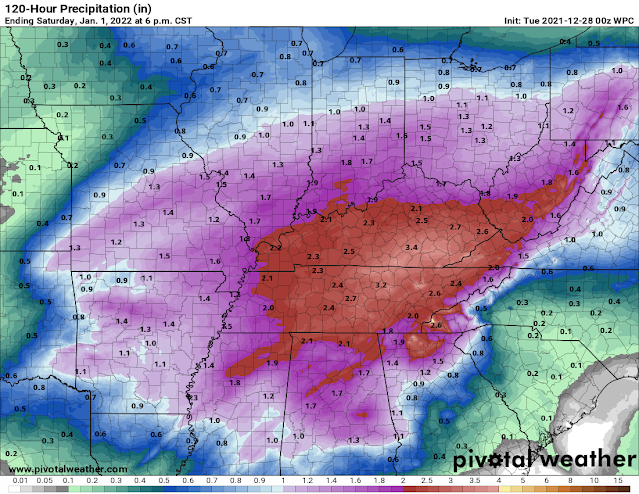
National weather service rainfall forecast through Sunday morning. A widespread 1-3” of rain is likely for the Mid-South, with locally higher or lower amounts possible. (NWS/SPC via Pivotal Weather)

This will be the last push of very mild air - highs once again will reach the 70s on New Year’s Day. Another threat to watch out for will be brief flooding, as we could see a couple of rounds of rain and storms on New Year’s Day. Rainfall amounts over the next five days will be between 1-3 inches for the Memphis area, with locally higher amounts possible. The good thing is that recent conditions will help to offset a flooding threat from any heavy rainfall we receive. The cold front moves through Saturday night, setting the stage for a frigid Sunday!

Winter arrives next week!

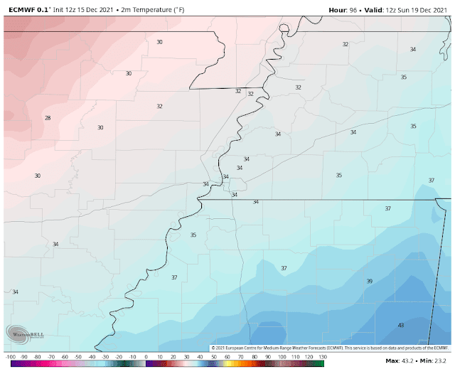
A powerful cold front will push through the area Saturday night, leaving us with plummeting temperatures for Sunday. Morning lows look to be just above or near freezing with highs only in the lower 40s, or about 30 degrees colder than Saturday! With a bit of lingering moisture and very cold temperatures, some snowflakes can’t be ruled out Sunday! For now, we're not looking like anything impactful, so don’t run out for bread and milk just yet! However, both major models (European and American GFS) are hinting at the possibility, so we’ll keep watching as the week goes on. Sunday night, with clear skies, lows will plunge into the mid 20s, with some models even hinting at low 20s and teens by Monday morning! It will be quite the change from the absolute torch that was the month of December.

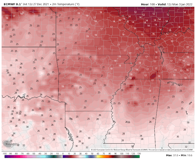
European model temperatures on Monday morning. This is NOT a forecast, just a model, but just goes to show the potential for very cold temps to start next week! This particular model run has us starting Monday in the upper teens. (WeatherBell)

Personal note

This will be my last blog for MemphisWeather.net, and today is my last day as an intern! It has been such a pleasure writing blogs and covering the past 8 months of wild weather in the Memphis area. I’m very grateful to have had such a great experience, and I will miss writing and tweeting about weather in the Mid-South! I graduated earlier in the month of December from Mississippi State with a Bachelor of Science in Meteorology, and I am currently a meteorologist at WCBI news in Columbus, MS. Follow me on twitter @christianbwx to see my next adventures! With that, meteorologist/intern Christian Bridges signing off :-) 

Christian Bridges
MWN Meteorologist Intern

----
Follow MWN on Facebook and Twitter for routine updates and the latest info!
Complete MWN Forecast: MemphisWeather.net on the mobile web or via the MWN mobile app
Download our iPhone or Android apps, featuring StormWatch+ severe weather alerts!
MWN is a NOAA Weather Ready Nation Ambassador Meteorologist Erik Proseus is an NWA Digital Seal Holder

Friday, December 24, 2021

Christmas and year-end forecast - unusually warm


This year, there's a lot of truth to that meme. I hope Santa has a pair of shorts and a t-shirt at the ready this year! Why is it so stinking warm out? 

A few lecture notes from Weather 102 

We have to look up - at the upper atmospheric pattern over North America, which is pretty much like a massive roller coaster, and it's persistent! Below we see the average upper air pattern over the continent for the week from Christmas to New Year's Eve. It all starts with a massive high pressure ridge over the North Pacific (red/pink colors are much above average). Like waves in the ocean, right ahead of a crest there is a valley. Look downstream in western Canada and the western U.S. - a n anomalously deep trough (blues to light greens). Because of that trough, there is a large area of high pressure downstream from that, which is centered over the Gulf of Mexico, but has a reach into the southeast U.S. that any social media influencer would appreciate. That pattern has been in place for a few days and, in general, it'll stick around through much of next week!

The European model ensemble average pressure pattern at about 18,000' up (500mb for you nerds). The white line helps to visualize the roller coaster pattern of the ridge/trough/ridge pattern. (WeatherBell)

Where there is high pressure above, there are usually warm temperatures below. Here is the corresponding temperature anomaly map for the same period - Christmas Day through New Year's Eve. Blowtorch. Average temperatures about 22 degrees above normal for the entire week in the Memphis area. (Note the corresponding freezer in southwest Canada where it's 20-30 degrees below normal.)

The European model ensemble average temperature departure from normal for December 25-31. (WeatherBell)

That's cool - but break it down for me, Erik

So what does this mean practically for Christmas weekend into next week? In a nutshell, too warm for the last week of 2021!
  • Highs in the 70s and lows in the upper 50s to 60s today through Wednesday
  • Daily high temperature records are in jeopardy Christmas Day (76), as well as Tuesday (74) and Wednesday (72).
  • Daily maximum low temperature records also in jeopardy on several days
  • An average high temperature of 73 degrees from today through Wednesday would be the warmest such stretch since 1889!
I also looked back to the last time we had 70 degree temperatures on Christmas - which was just 2 years ago. It was very warm for a stretch of days that week as well. The average high during that stretch was 68.5 degrees. Again, we're in line for an average high of 73. In addition, mornings that week were in the 40s to mid 50s. Other than Sunday morning, we probably won't see anything below 60 until Thursday. That means dewpoints are higher (muggier), keeping those overnight lows from falling. Here's a look at the warmest Christmas Days on record:


So let's break it down day by day...

Christmas Eve and Christmas Day

Morning clouds today give way to afternoon sunshine. Very gusty wind to 35-40 mph will help those temperatures reach the low 70s. Not a record, but very warm. It stays mild on strong southerly flow overnight, so Santa needs to start his descent into Memphis from the south for optimal fuel efficiency! It'll be in the low 60s when you wake up to open presents Christmas morning. That's about 12 degrees warmer than the typical high temp! Partly sunny for your Christmas Day with highs in the mid 70s and a continued gusty south wind. Great day for outdoor gatherings if you can hang on to your Chinet plates and wrapping paper.


Sunday into Monday

A cold front will try to sneak south to around the I-40 corridor Sunday night. That will give us a reprieve from the wind and slightly cooler temperatures Sunday morning, but still no rain. Look for lows in the mid 50s. However, like the 4th wave of covid, high pressure to our south says "not so fast" and shoves the front back to the north Sunday afternoon, bringing back south wind and highs again eclipsing 70.

By Monday, the ridge has regained its default position and, despite some cloud cover, another warm and breezy day with lows in the low 60s and highs in the mid 70s. Monday's record of 77 is likely safe.

Tuesday/Wednesday

With the upper ridge well established again, warmth remains. Tuesday could see a few showers and some gusty wind, but highs reach the mid 70s. The morning max low temperature record is 61 and the record high is 74. Both are quaking in their boots (or maybe flip flops). 


As we head into Wednesday, things start to change a bit. Another cold front approaches and this time it appears it could bring some moisture. It'll still be quite warm as the upper ridge still has influence. We're expecting 70 degrees or higher again, but that's thanks mainly to lows in the 60s, so not much warming needed to be near the record again. If the ridge stays stronger, it could delay the front a bit. For now, Wednesday has a 60% chance of showers and a few thunderstorms. Not looking like severe weather so we're good there.

Goodbye 2021, hello 2022!

Lots of uncertainty in the model data this far out, but if all goes to plan, Thursday we're on the north side of a cold front - a reprieve from the "heat!" A few lingering showers are possible but temperatures look to start around 50 (better, but still the average HIGH for the day) with lows in the low 60s. New Year's Eve looks similar, though the front could start to move back into the area, so all bets really are off on precipitation at this point. Relative warmth looks to continue with highs in the 60s. 

Most model ensembles are suggesting another, stronger, front arrives for New Year's Day. This would knock those temperatures down once again, maybe to "slightly above normal" heading into the start of the New Year. Given this is still a bit over a week out, the forecast is probably about as good as last year's January resolutions... stay tuned.

Erik Proseus
MWN Meteorologist

----
Follow MWN on Facebook and Twitter for routine updates and the latest info!
Complete MWN Forecast: MemphisWeather.net on the mobile web or via the MWN mobile app
Download our iPhone or Android apps, featuring StormWatch+ severe weather alerts!
MWN is a NOAA Weather Ready Nation Ambassador Meteorologist Erik Proseus is an NWA Digital Seal Holder

Thursday, December 23, 2021

Christmas Day weather history for Memphis


Undoubtedly one of the most common questions meteorologists get during the holiday season: “Any chance of a White Christmas this year?” That is no less true here in the Mid-South where a significant snowfall at any point in the winter season can be a unique (and disruptive!) event. Fortunately, thanks to a lengthy modern weather record available for Memphis that dates back to 1875, we have a pretty good idea just how likely a White Christmas is, at least statistically speaking. As you'll see below, and as you were already expecting, the odds are not in snow lovers’ favor!

Before jumping ahead to our chances of a White Christmas, here are some temperature statistics for Christmas Day in Memphis, thanks to data compiled by NWS Memphis and the National Climatic Data Center. The coldest Christmas Day in 146 years of records was in 1983 as a major Arctic air outbreak was gripping much of the nation. The high in Memphis that day was a mere 16 degrees after a bone-chilling morning low of 0! No snow that day, though it was plenty cold enough to support it!

High/low temperature map Christmas morning 1983. Brutal cold dominated the nation along/east of the Rockies except south Florida.

On the flip-side, the warmest Christmas Day in the records was in 1889 where the temperature reached a balmy 76 degrees after a mild low of just 63, a month that ended up by far the warmest December in Memphis history. When you average it out over 140+ years of records, a seasonable Christmas Day isn't too bad - with a high temperature of 48 degrees and a low near 33 degrees and skies that average partly cloudy to partly sunny at worst. One particular note of late though, is that 3 of the last 6 Christmas Days (including 2021) have had high temperatures of 68 or warmer.

In terms of any type of precipitation, measurable amounts (0.01” or more) have fallen on Christmas Day 38 times. The vast majority of those years featured just liquid rainfall in mainly light amounts, but one major soaker occurred in 1987 when 4.24” of rainfall was reported at Memphis, following an equally soggy Christmas Eve. Some Mid-South residents spent that Christmas dealing with flooding, the hardest hit of those in West Memphis, AR where cleanup was still underway after a destructive F3 tornado just 11 days earlier on December 14. There have been nine times that more than an inch of rain has fallen on Christmas Day, most recently in 2015 (1.61"). Sleet or freezing rain has been reported on Christmas Day a handful of those times, but just trace or light amounts.

Now the statistic you most want to know. Just how likely (or unlikely!) is a White Christmas in Memphis? The answer definitely lies on the “unlikely” side of the equation; in fact it’s more appropriate to label a White Christmas in Memphis as exceptionally rare. Only once in over 140 years of records has measurable snowfall occurred. That was in 1913 when 3.5” of the white stuff made for the sole exception to the rule we still consider today. However, there have been several other years where snowflakes have been seen in the Memphis skies on Christmas Day but with no accumulation. The most recent was in 2012, a year where Memphis just barely missed an all-out blizzard that hit parts of Arkansas on Christmas Night, with around an inch of snow falling the morning after Christmas in Memphis. In fact, during the four-year span from 2009-2012, snow flurries fell three times on Christmas Day!

Listing of all recorded snowfalls on Christmas Day at Memphis International Airport

Officially, the National Climatic Data Center considers any city to have a “White Christmas” if at least one inch of snowfall is on the ground on Christmas morning, no matter when that snowfall occurred. Using this definition, Memphis does have a few additional years it can add to that list. Those include 1962, 1963, 1998, and 2004, in addition to the 1913 snowfall that occurred on Christmas Day. 2004 is likely the most remembered as the city had around 2” of a sleet and snow mixture covering the ground following a winter storm on December 22. Long-timers of the Memphis area may even better remember the historic Memphis snow of December 22, 1963. 10” of that 14.3” snowfall total still lay on the ground that Christmas morning!
Official "White Christmases" in Memphis, which had at least 1" of snow on the ground.


When considering the NCDC criteria, the odds of a White Christmas in Memphis - with at least 1" of snowfall on the ground - end up right at 3%. Slightly better than the 0.8% odds if you only consider measurable snowfall on Christmas Day itself! Either way, clearly the odds don't fall on your side if you're looking for a White Christmas and want to spend the holiday in Memphis. Perhaps one Christmas soon we'll be able to make a new exception to the rule! Until then, average expectations for any given year would indicate a cool, but not cold, Christmas Day and at best modest chances of precipitation, which almost always falls in liquid form.

Top Image is "Graceland Christmas" by Thomas Kinkade, borrowed from artofthesouth.com.

Blog originally authored by MWN Intern Kevin Terry
Updated by MWN Meteorologist Erik Proseus

----
Follow MWN on Facebook and Twitter for routine updates and the latest info!
Complete MWN Forecast: MemphisWeather.net on the mobile web or via the MWN mobile app
Download our iPhone or Android apps, featuring StormWatch+ severe weather alerts!
MWN is a NOAA Weather Ready Nation Ambassador Meteorologist Erik Proseus is an NWA Digital Seal Holder

Wednesday, December 15, 2021

Mild with storms to end this week, then much more seasonable Christmas week

It’s a day of wild weather across the central United States, with a wide swath of damaging winds extending across Colorado, Kansas, Nebraska, South Dakota, Iowa, Minnesota, and Wisconsin! There is also a major severe weather risk, as a squall line blasts across the upper Midwest with 80-100mph winds and embedded tornadoes, some of which could be strong. The Storm Prediction Center has put the area under a level 4 of 5 risk for damaging winds and tornadoes just a few days after a tornado outbreak swept through the Mid-South and Ohio Valley. This is completely unprecedented for December in the upper Midwest! 

Thankfully, no major severe weather is expected here. However, another round of unseasonable warmth followed by thunderstorms is in the cards for the Mid-South this week. An initial round of showers and thunderstorms will move Thursday into the overnight hours, with a second round coming through on Saturday. A cold front will stall out Thursday night right across or just north of the metro, with temperatures not budging much for most of us. Then, on Saturday, the front finally pushes through the Mid-South with falling temperatures. Heading towards Christmas next week, we finally return to seasonable December weather, with chilly nights and sunny, cool, and crisp days. We deserve it after the severe weather last week! 

Animation of the temperature see-saw over the next few days (through Saturday afternoon), from the GFS (American) model. Luckily, we avoid the extreme weather to our west! (WeatherBell)

Thunderstorm round #1: Thursday into Friday

As the cold front makes its initial push into our area, temps will stay warm with lows near 60 overnight and up to 70 or just above Thursday and Friday afternoons as south winds bring in Gulf moisture. Winds could be fairly gusty on Thursday, especially in heavier downpours and thunderstorms. A line of showers and thunderstorms will move towards the Mid-South, slowing down as they approach the area as a cold front stalls. The line will then begin to move back to the north Thursday night as the front retreats as a warm front. Some models depict a broken line of showers and storms, and some depict a more solid line. Either way, storms could have heavy rainfall and gusty winds, especially west of the Mississippi River. After the front lifts north of the area Friday morning, we’ll dry out for a bit with just a few scattered showers lingering for the afternoon hours and warm temperatures once again.

HRRR model depiction off showers and thunderstorms moving through the area Thursday afternoon into Friday morning. Best severe threat stays to the west, but gusty winds can’t be ruled out (WeatherBell)

Thunderstorm round #2: Saturday

The cold front finally makes it back to the metro area on Saturday morning, as a large area of high pressure to our north finally budges to the east. This will once again push a line of showers and possibly a few storms through the metro during the morning, but at this time it looks like it will be weakening as it does so, with a minimal severe threat. Still, some gusty winds, heavy rain, and lightning can’t be ruled out as the front pushes through. Temps will then fall from the low/mid 60s in the morning into the 40s by the time the sun goes down Saturday. Lows will plunge back to near freezing Saturday night.

MUCH calmer next week, feeling like the holiday season!

Much cooler temps return by the weekend. There is widespread model support for lows in the low 30s by Sunday morning, with a frost or freeze likely. (Euro mode via WeatherBell)

The weather calms down and gets into the holiday spirit for next week. A large area of high pressure will move in beginning Sunday, with chilly temperatures and lots of sunshine. Highs will only be in the low to mid 40s on Sunday! We rebound as the week goes on, with nights remaining chilly in the 30s and highs slowly rising through the 50s. We’ll be in the low 50s Monday, mid 50s Tuesday, and upper 50s by Wednesday.

Early look at Christmas weather

An early look (very early, so should be taken with a big grain of salt!) shows seasonable weather, if not a bit warmer than normal. At this time, we're not looking for anything record-breaking, and it’s also looking dry. That would mean a high in the upper 50s to around 60, with a mix of sun and clouds. This could easily change over the next 10 days, so stay tuned as the forecast is further refined!

European model ensemble depiction of temperature anomalies for the 5 day period from Dec. 21-26th. Warmer than average, but not looking record breaking. Other models are fairly in line with this as well. (WeatherBell)

Christian Bowles
MWN Intern

----
Follow MWN on Facebook and Twitter for routine updates and the latest info!
Complete MWN Forecast: MemphisWeather.net on the mobile web or via the MWN mobile app
Download our iPhone or Android apps, featuring StormWatch+ severe weather alerts!
MWN is a NOAA Weather Ready Nation Ambassador Meteorologist Erik Proseus is an NWA Digital Seal Holder

Saturday, December 11, 2021

Recapping Friday night's storms, plus a moment of gratitude

Decided it would be appropriate, maybe cathartic, to sit down a put a few thoughts on electronic paper after last night's severe weather outbreak. 

First, a bit of a recap. The Memphis metro was very fortunate! Monette Manor nursing home, which was devastated by the tornado that ended up traveling over 250 miles through AR, MO, TN, and KY, is 55 miles from downtown Memphis and just 35 miles from western Tipton County.. 
That tornado would go on to destroy the town of Mayfield, KY, over 110 miles away.
Looking at NEXRAD Doppler radar estimates of rotation, that tornado (or at least its parent storm, possibly producing multiple tornadoes) traveled over 250 miles in a few hours. If determined to be a singular tornado, it would set the record for the longest path length in recorded history. You can easily pick it out in the image of rotation tracks from last night:

MRMS radar data showing where rotation was observed Friday evening into the night. Higher values mean stronger rotation. (MRMS via the NWS)

But if you look at that image more closely, you'll see how many areas had rotating storms pass overhead. Not all produced tornadoes, but the parent supercells were rotating aloft. There is even some rotation in the metro, particularly along and south of I-40, though more sporadic than the long-tracked events to our north. Locally, two Tornado Warnings were issued for Shelby County. One was for storm circulation that developed over West Memphis and moved into Shelby Forest towards Millington before dissipating. A second right behind it had a stronger rotation signature near the Fairgrounds and moved across the Sam Cooper area and basically along I-40/Highway 70 into northwest Fayette Co. A spotter report of a funnel cloud or brief tornado touchdown was received near the Airline Road exit at I-40 heading into Fayette Co, but so far no damage reports have been received that we are aware of.
If you want to re-live the entire event, here are a few recap images. First, a radar loop of the entire night, from 5pm Friday to 5am Saturday.

Radar loop for the Mid-South from 5pm Friday to 5am Saturday (MRMS via WeatherBell)

Here's a recap of the event from the perspective of the National Weather Service, showing their  midday Friday severe weather outlook (when the Level 4 Moderate Risk was issued), preliminary severe weather reports, and Tornado Warnings issued. Honestly, it's hard to get a whole lot better than that from the perspective of the Storm Prediction Center, who issues these outlooks. They are the severe weather experts and are exceptional, particularly on the big events. We had known something was brewing as early as Monday.

Summary of NWS severe weather outlook and tornado warnings issued, with storm reports overlaid. Graphic credit: Jack Sillin

By the way, the high-resolution computer modeling that we use to help pinpoint timing and location of threats on the day of an event did an overall remarkable job. These advances in science are saving lives by giving people like us good information to relay to you. Check out the forecast below from the HRRR, our best short-term forecast model. It is a forecast from noon yesterday showing where supercell rotation and possible tornadic activity would occur between 6pm and midnight. It basically nailed the exact path of the long-track storm that produced tornado damage from Monette to Mayfield and beyond. Simply astonishing.

The 18Z (noon Friday) HRRR model forecast showing where it believes rotating storms will occur. This image is for the period between 6pm and midnight Friday. (WeatherModels)


A personal moment of reflection and gratitude

So, while we were very fortunate, there are others that are less so this morning. Our hearts ache for those places where destruction occurred, where lives were turned upside down in a matter of minutes. 

For the elderly folks in a nursing home in Monette literally having the roof lifted from above their heads and debris raining down, and losing a fellow resident and friend in the process. 

For the town of Mayfield that was nearly, literally, wiped off the map. 

Bowling Green - where a Western Kentucky University student lost a relative the day before walking the stage to receive a degree. 

Amazon workers near St. Louis - who witnessed the walls and roof come crumbling down under the stress of high wind.

And many others that won't make the national news, but are hurting just the same.

Amongst the destruction though, there are heroes. The headlines and news stories will laud the first responders and the doctors and nurses, all of whom indeed deserve every bit of praise for their heroic acts. They rush towards the destruction, or into medical facilities, all to serve others. And many of them are also personally affected because the storms hit the communities they serve and affect people they know directly.

But there are those who get less credit - who aren't the first ones called out by governors and mayors for their heroism and aren't named in news stories. 

They are the scientists that make the jobs of those first responders less burdensome. They save lives simply through public awareness, directly resulting in fewer that need emergency assistance. They are the men and women who build the weather models, that issue the severe weather outlooks days in advance to raise awareness, that issue and communicate the forecasts locally, and then sound the alarm with severe weather warnings to prompt action to be taken by the public. The meteorologists who live in the communities they serve, and have family members at home taking cover while they go above and beyond to serve, and also heroes - on days like yesterday, and every day. 

So today, I want to thank my colleagues in research, operations, and broadcast among other sectors, for their dedication to public service. They are underappreciated, and particularly after a night like last night, deserve our collective gratitude.

Erik Proseus
MWN Meteorologist

----
Follow MWN on Facebook and Twitter for routine updates and the latest info!
Complete MWN Forecast: MemphisWeather.net on the mobile web or via the MWN mobile app
Download our iPhone or Android apps, featuring StormWatch+ severe weather alerts!
MWN is a NOAA Weather Ready Nation Ambassador Meteorologist Erik Proseus is an NWA Digital Seal Holder

Thursday, December 9, 2021

Severe weather outlook for Friday night

The Setup

A warm front will move north over us early Friday morning, bringing (even more) warm and humid air into the Mid-South.  A slow-moving cold front over the Central Plains will move southeast on Friday, picking up speed and reaching the Mid-South early Saturday.  This will lead to the potential for severe thunderstorms late Friday evening into Saturday morning, with the possibility of damaging wind gusts and a few tornadoes.

Surface features and precipitation from Thursday night thru Saturday night (NOAA/NWS)

Thursday's Model Guidance

As of  Thursday afternoon, computer models are differing on where and when the storms will develop, with the possibility of either storms developing after 9pm over us, or waiting until around 2am.  With either scenario, we should expect the possibility for severe storms late Friday and into early Saturday morning.

Comparison of the HRRR and NAM3 models valid at 3am Saturday, showing widely different scenarios. (PivotalWeather)

What's Gonna Happen?

Gusty southwest winds, warming temperatures and increasing humidity are expected on Friday. High temperatures will reach the mid 70s fairly easily, with dewpoints in the high 60s (fairly absurd for this time of year, to be honest). By Friday afternoon and early evening, expect scattered showers and gusty south winds.  For Friday evening after about 9pm, scattered strong to severe storms will be possible, but we're not completely convinced these will happen (see next paragraph).  Late Friday night into early Saturday morning, expect another potential wave of strong to severe storms moving in from eastern Arkansas ahead of the cold front.  The severity of these storms could well depend on how round one in the late evening plays out.  By Saturday around daybreak, expect a final quick round of showers along the cold front, followed by gusty northwest winds and much colder temperatures moving in.

The Storm Prediction Center severe weather outlook for Friday night places Memphis squarely in a level 3 risk out of 5 (Enhanced), indicating scattered severe storms are likely. (SPC)

Uncertainty

One of the biggest uncertainties, as described above, is the conditional chance for storms Friday evening.  If they happen, they would have the biggest severe threat, have a higher potential for tornadoes and likely lessen the severe threat during the early morning hours on Saturday.  If they don't occur, the severe threat would be highest after 2am Saturday, with damaging winds and a lower (but still possible) tornado threat. Clouds and scattered showers over us on Friday would lessen the severe threat (which is the most likely scenario), while a bit of sunshine would mean a higher severe threat Friday evening.


To wrap up...

There is a threat for severe weather Friday night into Saturday morning.  We will get thunderstorms, with some likely to be severe.  Depending on when we see these storms will determine how severe they will be.  We will know more on Friday, so please continue to check our latest posts on social media (Twitter & Facebook).  But we're not expecting a widespread severe weather outbreak here, just some strong to severe storms during the evening and/or overnight hours Friday night into Saturday.

So be prepared, not scared, for severe weather Friday night into early Saturday morning.  Below are some tips you can follow leading up to the event.


Richard Hoseney
MWN Meteorologist

----
Follow MWN on Facebook and Twitter for routine updates and the latest info!
Complete MWN Forecast: MemphisWeather.net on the mobile web or via the MWN mobile app
Download our iPhone or Android apps, featuring StormWatch+ severe weather alerts!
MWN is a NOAA Weather Ready Nation Ambassador Meteorologist Erik Proseus is an NWA Digital Seal Holder

Wednesday, December 8, 2021

November 2021 Climate Report for Memphis, TN

November Climate Recap

Coming out of a warmer than average October, November cooled off quite a bit and ended below average by more than a degree. There was one significant, if brief, warm spell mid-month as highs reached the mid 70s, but overall there were fairly large swings during the month. Nineteen days ended at or below average though, resulting in a fairly comfortable month of fall. A handful of rain days were spread out across the course of the month with several dry days between each. For the month, only six days recorded measurable precipitation, ending 2.58" below, or 45% of, average. Thunder was noted on just two days with no warnings or severe weather reports for the month. 


Memphis International Airport, Memphis, TN

Temperature 
Average temperature: 51.5 degrees (1.2 degrees below average) 
Average high temperature: 62.4 degrees (0.2 degrees below average) 
Average low temperature: 40.6 degrees (2.3 degrees below average) 
Warmest temperature: 77 degrees (17th) 
Coolest temperature: 29 degrees (26th) 
Heating Degrees Days: 402 (23 above average)
Cooling Degree Days: 6 (6 below average) 
Records set or tied: None
Comments: One day dropped below freezing (26th) versus an average of 4.3 days on November.

Precipitation 
Monthly total: 2.11" (2.58" below average) 
Days with measurable precipitation: 6 (3.0 days below average) 
Wettest 24-hour period: 0.61" (11th) 
Snowfall: 0.0"
Records set or tied: None
Comments: None

Miscellaneous 
Peak wind: Southwest/35 mph (17th) 
Average wind: 7.0 mph 
Average relative humidity: 63% 
Average sky cover: 38% 

 Click here for a daily statistical recap for Memphis International Airport.
 

Cirrus Weather Solutions / MemphisWeather.net, Bartlett, TN

Temperature 
Average temperature: 48.6 degrees 
Average high temperature: 61.7 degrees 
Average low temperature: 36.6 degrees 
Warmest temperature: 77.2 degrees (17th) 
Coolest temperature: 26.6 degrees (26th) 
Comments: None 

Precipitation 
Monthly total: 2.50" (automated rain gauge), 2.55"(manual CoCoRaHS rain gauge) 
Days with measurable precipitation: 8
Wettest date: 0.76" (21st) (via automated gauge) 
Snowfall: 0.0"
Comments: None

Miscellaneous 
Peak wind: Southwest/24 mph (24th)
Average relative humidity: 73% 
Average barometric pressure: 30.19 in. Hg
Comments: A new Davis Vantage Pro2 weather station replaced the existing station on November 19 at 12:30pm.

Click here for a daily statistical recap for Bartlett, TN.
 

MWN Forecast Accuracy

MWN average temperature error: 1.69 degrees 
MWN forecast temperatures within 2 degrees of actual: 77% 
MWN average dewpoint error: 1.92 degrees 
MWN forecast dewpoints within 2 degrees of actual: 74% 

MWN's forecasts extend out five periods (2.5 days, or roughly 60 hours). Historical accuracy statistics can be found here.
 

Climate Outlook - December 2021

The December climate outlook for the United States from the Climate Prediction Center is shown below. Above average temperatures are forecast for a vast majority of the U.S with highest odds across the southern states. Odds strongly favor above average temperatures for Memphis over the course of the month (65%) versus only a 3% chance of below average temperatures. The average temperature for December is 44.8 degrees, eight degrees below the November average.


Precipitation is expected to be above normal for the Pacific Northwest and Northern Rocky Mountains, while below average precipitation is forecast for Southern Plains into the southeast U.S. For Memphis, odds favor near average precipitation, which historically averages 5.49 inches in December.

--- 
Follow MWN on Facebook and Twitter for routine updates and the latest info! 
Complete MWN Forecast: MemphisWeather.net on the mobile web or via the MWN mobile app 
Download our iPhone or Android apps, featuring StormWatch+ severe weather alerts!
MWN is a NOAA Weather Ready Nation Ambassador Meteorologist Erik Proseus is an NWA Digital Seal Holder

Saturday, December 4, 2021

Unseasonable warmth departs; severe weather possible early Monday

A warm start to meteorological winter resulted in record-setting warmth on Friday as high temperatures reached the mid 70s, setting a record of 76 degrees at Memphis International. 


It stayed mild overnight as temperatures remained in the 60s ahead of a slow-moving (stalling, actually) cold front that sits over far northern MS this afternoon. We had some patchy fog and areas of drizzle this morning for the St. Jude Memphis Marathon. I'm sure the runners would have preferred cool and dry with lower humidity.

Saturday afternoon through Monday morning 

Conditions are pretty stable for the rest of today and tonight as the front doesn't move, allowing clouds to stick around and temperatures remain to be mild. Low 60s this afternoon and 50s overnight. A stray shower is possible due to the proximity to the front. Overnight the front starts to return to the north with wind switching from north back to south by Sunday morning. 

On Sunday, we'll be back in the "warm sector" ahead of a more significant front that arrives Monday morning. Temperatures will warm once again to 70 degrees or a bit higher with gusty southwest wind. Most of the day will be under cloud cover, but breaks in the clouds are possible and will offer more warming and increasing instability in the air. Scattered showers are possible, and maybe a stray thunderstorm, but overall the lower atmosphere will remain capped to storm development during the day. Don't lose track of the waterproof wind breaker Sunday.

The midday Saturday HRRR model showing "future radar" loop from noon Sunday to noon Monday. Scattered showers Sunday, then quick development of a squall line Sunday night, arriving Monday just before or during rush hour. (WeatherBell)

The cold front lights up to our northwest Sunday overnight as it enters Arkansas from the north. As storms develop, a few may become strong to severe. ETA for a fairly well-developed squall line in the Memphis metro is estimated to be just before sunrise Monday. The main threats will be heavy rain which could produce ponding water in time for rush hour and scattered strong to damaging wind gusts. There is a non-zero chance of a quick spin-up tornado within the line as well, but the threat is fairly low. Overall, the severe weather risk places the Memphis metro in a Level 2 (Slight) Risk. 


Severe weather prep

Because the storms will arrive while most of us are either sleeping or just waking up Monday morning, having a way to get severe weather warnings will be important. Widespread severe weather is not currently anticipated, but having multiple methods of receiving information is necessary. We recommend SW+ Alerts in our MWN app as one such way. 


Also recommended: get those outdoor Christmas decorations and other loose objects secured by Sunday afternoon as the wind starts picking up to 25 mph or higher. Leaves in gutters and storm drains could also contribute to low-lying flooding or other water issues so a quick cleanup would be a good idea as well.

Next week

Cool weather and clearing skies are expected Monday behind departing showers Monday morning. A gusty north wind and prior warm weather will make temperatures near 50 feel even colder Monday. Tuesday morning we wake up to clear skies and cold conditions. Clouds start to return Tuesday with highs only in the upper 40s - another chilly day. Wednesday has trended drier in recent model data as a system moves by to our south and another to our north. Best rain chances will likely be south of Memphis Tuesday night, but for now a low rain chance mid-week is justified. Wednesday will be cool again with highs near 50. Lows look to mostly remain above freezing the first half of the week, though outlying areas could dip to 32 Tuesday morning.

The European model for Monday evening through Wednesday evening shows mainly dry conditions for the Mid-South. A couple of systems split the area Tuesday night with rain and snow passing by well to our north and rain showers likely missing us to the south. (WeatherBell)

By Thursday, another quick-moving front slides through the Mid-South. The front could bring a brief rain chance Thursday as highs climb to the upper 50s. Southerly warm wind arrives again Friday with temperatures back well into the 60s. The next major system looks to arrive next weekend with another chance of heavy rain and thunderstorms. More on that as we get closer. Overall, a very progressive pattern over the next week as one system after another moves through!


Stay tuned to our social media feeds for the latest on Monday's severe weather threat. 

Erik Proseus
MWN Meteorologist

----
Follow MWN on Facebook and Twitter for routine updates and the latest info!
Complete MWN Forecast: MemphisWeather.net on the mobile web or via the MWN mobile app
Download our iPhone or Android apps, featuring StormWatch+ severe weather alerts!
MWN is a NOAA Weather Ready Nation Ambassador Meteorologist Erik Proseus is an NWA Digital Seal Holder