
Well, that was fun!
That is one way to describe about 3 days on non-stop hand-wringing over one of the most challenging winter weather forecasts this meteorologist has encountered in 25 years of forecasting the Memphis area. Friday's blog described the scenario - one in which a rare atmospheric setup resulted in an upper level low taking a giant hook over the southern Plains towards the area and merging with surface low pressure over the Deep South. Even our most reliable medium-range global models and short-term high-resolution models struggled with consistency and output, with wild swings in potential snow amounts for the area. Add in the potential for "banding" of snow in small areas due to the power of the upper low, and you end up with a very challenging event.
In the end, on Friday I decided on rain changing to snow near or after midnight, potential heavy in the early morning hours, tapering in the hours after sunrise, and "generally 1-4 inches with the greatest probability of the higher amounts east of Memphis." I also said in the blog "localized bands could produce up to 4-6" of snow." And with a little bit of luck, that verified pretty well if I do say so myself.
How it ended:1:30am Big chunky silver dollar-sized flakes! 33.5° #memsnow@NWSMemphis pic.twitter.com/eowgOYDxLZ
— MemphisWeather.net (@memphisweather1) January 16, 2022
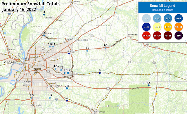 |
| A preliminary listing of snowfall totals from across the Mid-South can be found here. |
Overall, 1-2" is what the immediate metro received with lower amounts closer to the river and higher amounts in eastern rural areas. Going further east, areas near the TN/MS state line east of the metro saw isolated amounts of up to 5-9"! The amounts in the city were slightly reduced by the "wetness" of the snow that fell. Typically, snow in the Mid-South has about an 8:1 to 10:1 snow ratio, meaning that for each 0.10" of liquid water that falls, about 3/4"-1" of snow can be expected. Because temperatures were just above freezing, relative humidity was above 90% and the amount of moisture above us was high, the snow ratio for this system ended up being closer to 5:1. That reduces potential snow totals by up to one-half of what would fall with snow that isn't so wet. We knew it would be a wet snow, but not quite THAT wet!
In addition we also saw that where snow came down hard (like in the video above where snow-globs were more than an inch in diameter as they fell), even with temperatures above freezing, the roads can coat pretty quickly. The fact that temperatures didn't get below freezing by much, or for long, meant that they also melted fairly quickly once the sun rose and snow ended.
Road conditions in the eastern metro, particularly E Shelby/Fayette are deteriorating. Slushy, but temps still at 33-34°. Snowfall rate is what is responsible despite temps >32. Sampling of traffic cams: SR385 @ US70, I-40 @ SR196, and I-40 @ Canada Rd. #memtraffic #memsnow pic.twitter.com/t9sV6sgDSI
— MemphisWeather.net (@memphisweather1) January 16, 2022
There were scattered power outages in the Memphis area and, tragically, one woman lost her life while driving a vehicle when a snow and ice laden tree fell over and landed on her car in southeast Memphis. But overall, it ended up being a manageable event for most.
Hopefully you were pleased with what you ended up getting today! Given the MLK Day holiday tomorrow, I expect no issues at all when work and school start back on Tuesday. If you are out early tomorrow though, you will want to keep an eye out for a little black ice in spots where melting occurred and left water on the roads tonight. Hopefully we don't have any more of those types of events again for a long while!actio
Erik Proseus
MWN Meteorologist
----
Follow MWN on Facebook and Twitter for routine updates and the latest info!
Complete MWN Forecast: MemphisWeather.net on the mobile web or via the MWN mobile app
Download our iPhone or Android apps, featuring StormWatch+ severe weather alerts!
 | |
| MWN is a NOAA Weather Ready Nation Ambassador | Meteorologist Erik Proseus is an NWA Digital Seal Holder |
No comments:
Post a Comment