Saturday, February 25, 2023

Despite a couple cool days, February warmth (and wind) continue next week

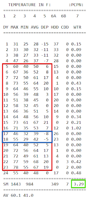
The month of January went into the books as one of the warmest and wettest on record (both ranking in the top 10th percentile). February has mainly continued that trend on the temperature side, with average temperatures 5 degrees above normal, and even threatening (and exceeding once) records earlier this week. 

Daily temps and precip for February 2023 to date. Note the generally well above average temperatures with only a couple of short exceptions. Though it seems like it has been raining a lot, we're about a half inch below average to this point in the month. (NWS)

Cool and damp to start the weeekend

That pattern was interrupted by a strong cold front that dropped high temperatures 25-30 degrees between Thursday and Friday. Cool, damp weather Friday continues into Saturday with temperatures in the 40s. The overall pattern though is still one that favors above average temperatures and we'll find ourself back there again to end the weekend, as highs climb back into the upper 60s with that Thursday cold front moving back to our north as a warm front. 

Back in the "warm sector," we'll have an unsettled regime in place leading into next week. This seems appropriate as we move towards meteorological spring, which starts on March 1 (Wednesday) and typically brings fairly large swings in temperatures and frequent showers, as well as warmer unstable air that can result in seasonal thunderstorms. This past week has also been Severe Weather Awareness Week, which is a good reminder that this time of year, the dynamic systems of wintertime often start tapping into more unstable air, which means the threat of severe storms starts to ramp up.


Starting the week windy

Looking ahead to the coming week, our first system of note arrives early and will bring showers late Sunday night and Monday morning. But more importantly, we'll have yet another very windy day (I think this is the third in the past 10-14 days) with wind gusts near 40 mph or higher starting after midnight Sunday night/Monday morning and continuing through Monday mid-day before starting to diminish a bit going into Monday afternoon. 

A strong front moving across the southern Plains with severe storms on Sunday night arrives in Memphis as mostly showers by Monday morning. HRRR forecast radar valid Sunday 6pm to Monday 6am. This front will also generate a lot of wind. (WeatherBell)

This potent low pressure system will produce the potential for severe weather Sunday in the southern Plains before quickly moving through the Mid-South, where unstable air is not nearly as big a concern. However, because of an anomalously large and strong high pressure system anchored over the far southeastern U.S., a strong low moving by our area will produce a pressure gradient between the two systems that will result in a #SkirtAlert at minimum and maybe some scattered power outages like the wind system we had earlier in the week. 
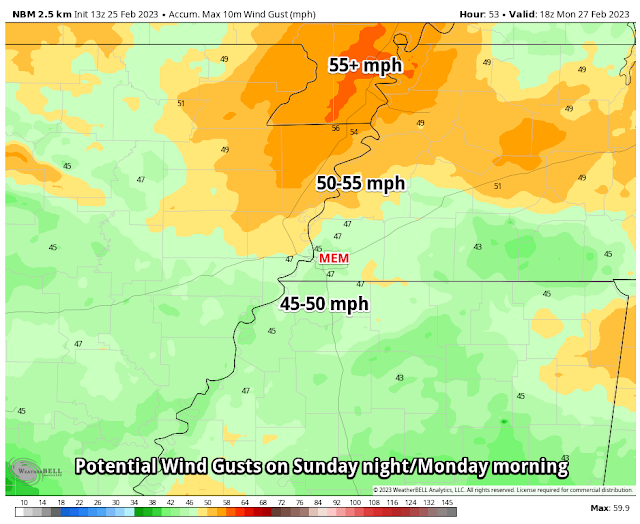
The NWS Blend of Models depicts maximum wind gusts with Monday morning's system. (WeatherBell)

Active pattern continues for the latter half of the week

Once this low and front move out, we'll catch a break for about 48 hours with a pleasant spring day on tap for Tuesday with just some high clouds moving by and temps near 70. Rain chances start moving back in Wednesday afternoon or evening, and this time stick around for much of the rest of the week as two weather systems pass by. The threat of severe weather looks to stay south of Memphis in the last half of the week, though a few thunderstorms are possible. Temps start warm (low 70s Wednesday), but gradually decline - to the mid 60s behind a rainy Wednesday night into early Thursday, and then the mid 50s by Friday.  

Generally the mid-range global models are not in great agreement on timing and position of a system that moves through the southeast at end end of the week, but a very potent low pressure system looks to slide by just to our south, with a threat of heavy rain somewhere near or south of the metro and severe weather in the Gulf Coast region. 

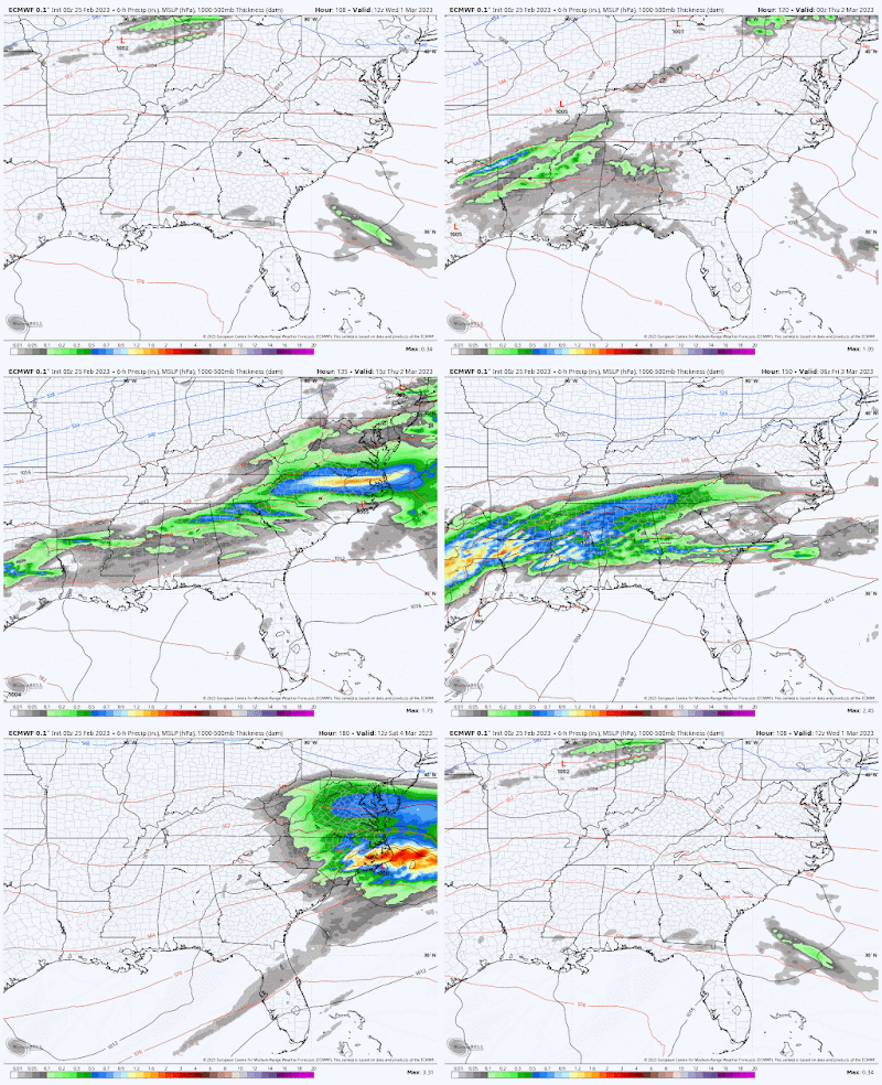
The Friday night run of the European model, valid Wednesday morning through Saturday morning (March 1-4) is not to be taken literally, but presents a similar picture as the American GFS model. One period of rainfall moves across the areas Wednesday PM to Thursday AM with another more potent system moving through the southeast on Friday. (WeatherBell)


Looking into the crystal ball

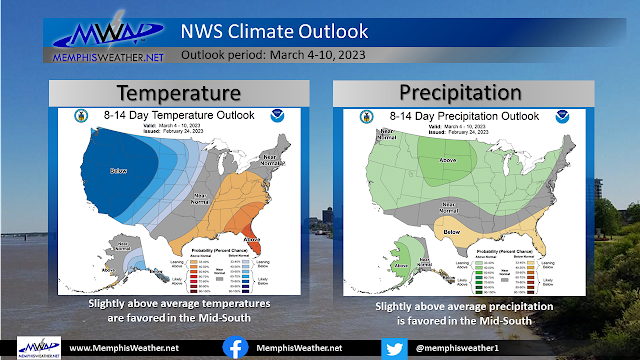
By next weekend, we'll be looking at mild temperatures and dry conditions. Beyond that, the week two outlook favors near or slightly above average temperatures and and precipitation. And there are some long-range signals (still just very generalized based on climate models and teleconnections) that temperatures could turn cooler as we head deeper into March. For now though, that is still in la-la land.


Erik Proseus
MWN Meteorologist

----
Follow MWN on Facebook and Twitter for routine updates and the latest info!
Complete MWN Forecast: MemphisWeather.net on the mobile web or via the MWN mobile app
Download our iPhone or Android apps, featuring StormWatch+ severe weather alerts!
MWN is a NOAA Weather Ready Nation Ambassador Meteorologist Erik Proseus is an NWA Digital Seal Holder

Sunday, February 12, 2023

Sunny days bookend a mild and stormy mid-week

We've got two wet systems to monitor this week - one wetter and stormier than the other - as well as a fair amount of wind to deal with. Keep all that in mind as you pick out clothes for mild temps, at least until Friday when the chill returns!

Monday

Valentine's week starts similar to the way Sunday ended, though a bit warmer, with sunny skies. The difference is that the wind is from the south, which means slightly warmer temperatures as morning lows remain above freezing in the upper 30s and highs reach the mid 60s. It should be an overall pleasant #FakeSpring day with blue sky until high clouds start arriving late in the afternoon.

Tuesday

The late day clouds Monday portend the first system of the week, the less robust of the two but one that sets the stage for the next. A front will bring showers during the day, mostly in the afternoon, but dropping less than 1/4 of an inch. It will be another mild day with highs in the mid 60s following morning lows in the 40s. The big story will be the wind though, and it will be the fiercest of the week outside of thunderstorms. Southerly gusts will reach 40 mph at times with steady wind in the 20-30 mph range in the afternoon. Definitely a #SkirtAlert kind of day! If you have Valentine's Day dinner reservations, most rain will be gone, but it will remain breezy.

The high-resolution NAM model shows what radar may look like between 8am-8pm Tuesday. Precip amounts should remain light, mainly in the afternoon. (WeatherBell)

Wednesday

Behind Tuesday's system, there will be no cold and dry air. In fact, leftover moisture and continued southerly wind will be the setup needed for the potential for severe weather on Wednesday night. Leading up to that, a mainly cloudy and dry day is expected during daylight hours. Temperatures will soar into the mid 70s, which will provide some instability to the atmosphere as a much more potent upper level system and cold front move across the southern U.S. towards the region Wednesday night. 

The weather map for Wednesday morning shows a lull in the action over the Mid-South with a storm system taking shape over the southwest U.S. that will move into the area Wednesday night. (NWS)

Behind a northward-moving warm front, showers will break out by evening with scattered thunderstorms expected as well. A strong and sheared wind field will be in place overnight with lingering unstable air, providing the ingredients for scattered to numerous thunderstorms. Some of these could be strong to severe. The biggest unknown, as is usual in the cool season, is the magnitude of unstable air, which will ultimately determine the strength of the storms and the associated hazards. At this point, all severe hazards are a concern - heavy rain and lightning, damaging wind gusts, hail, and a few tornadoes. We'll be able to better define these threats as we get closer in time, especially Wednesday when the amount of instability is better known and how well the atmospheric ingredients line up. For now, plan ahead of the potential for severe weather warnings and a possible need to react accordingly overnight Wednesday.

A severe weather outlook equivalent to a level 2 Slight Risk has been issued for Wednesday night by the Storm Prediction Center. All modes of severe weather are possible at this point. (SPC)


Thursday

A few lingering warm-weather showers will still be around Thursday morning ahead of the cold front that arrives in the afternoon but storms should be east of us. Temperatures start the day around 60 and rise a few degrees in the morning before the front arrives. Gusty northwest wind will help usher in cooler and drier air, bringing an end to spring like conditions as temps fall towards the upper 20s by Friday morning as the sky clears Thursday night .

Friday-Sunday

A chilly and breezy day is expected to end the week, with sunshine doing little to take the chill out of the air. Highs remain in the lower half of the 40s in the afternoon after morning wind chills approach the teens. A moderating trend is expected next week in the temperature department after another cold morning on Saturday. High clouds move through the sky over the weekend as highs reach 50 on Saturday and even warmer Sunday.


Erik Proseus
MWN Meteorologist

----
Follow MWN on Facebook and Twitter for routine updates and the latest info!
Complete MWN Forecast: MemphisWeather.net on the mobile web or via the MWN mobile app
Download our iPhone or Android apps, featuring StormWatch+ severe weather alerts!
MWN is a NOAA Weather Ready Nation Ambassador Meteorologist Erik Proseus is an NWA Digital Seal Holder

Monday, February 6, 2023

January 2023 Climate Report for Memphis, TN

January Climate Recap

Temperatures for the month of January in Memphis averaged above normal with high temperatures almost 6 degrees above average, and low temperatures over 6 degrees above average. The month started out warm with highs in the 70's, but by the 4th highs were back to the 50's.  A brief warmup occurred from the 10th to the 12th, with a cold front dropping temps back to near normal by the middle of the month.  Another warmup to the 70's happened around the 17th-18th, with a cold front dropping temps on the 19th back to the 50's.  Highs stayed in the 50's with lows just below freezing for the rest of the month, with the exception of the 31st, where we didn't get above freezing that day due to winter weather.

The temperature anomaly map for the month of January shows above average temperatures across the eastern half of the country, including the Mid-South. Some locations across the Northeast and Great Lakes averaged 10 degrees above normal. (PRISM temperature data via WeatherModels)

January was a wet month overall - almost 5 inches above normal - with 15 days in the month receiving precipitation. The 1st-15th of the month had almost 5" of precipitation, with the bulk of it falling on the 3rd (4.51" at the airport and 3.78" at MWN in Bartlett).  The last half of the month saw scattered amounts of rain fairly regularly, with over 1" of rain falling on the 29th and almost another 1" on the 30th-31st.  Multiple waves of sleet and freezing fell from the 30th through February 1st.


Memphis International Airport, Memphis, TN

Temperature 
Average temperature: 48.3 degrees (6.2 degrees above average) 
Average high temperature: 56.7 degrees (5.8 degrees below average) 
Average low temperature: 39.9 degrees (6.6 degrees above average) 
Warmest temperature: 74 degrees (1st) 
Coolest temperature: 25 degree (31st) 
Heating Degrees Days: 512 (198 below average)
Cooling Degree Days: 2 (1 above  average) 
Records set or tied: Daily high minimum (62 degrees on 12nd)
Comments: January's average temperature tied for 11th warmest on record.

Precipitation 
Monthly total: 9.13" (4.99" above average) 
Days with measurable precipitation: 15 (5.0 days above average) 
Wettest 24-hour period: 4.51" (2nd-3rd) 
Snowfall: 0.2" sleet, trace snow. (0.7" below normal)
Records set or tied: Daily maximum (3.84" on 3rd)
Comments: 0.2" of sleet was measured on the 31st and a trace of snow on the 25th.

Miscellaneous 
Peak wind: Northwest/41 mph (12th) 
Average wind: 8.5 mph 
Average relative humidity: 73%
Average sky cover: 62%

 Click here for a daily statistical recap for Memphis International Airport.
 

Cirrus Weather Solutions / MemphisWeather.net, Bartlett, TN

Temperature 
Average temperature: 47.2 degrees 
Average high temperature: 56.5 degrees 
Average low temperature: 38.1  degrees 
Warmest temperature: 73.9 degrees (1st) 
Coolest temperature: 25.1 degrees (31st) 
Comments: None 

Precipitation 
Monthly total: 9.74" (automated rain gauge), 9.28" (manual CoCoRaHS rain gauge) 
Days with measurable precipitation: 17
Wettest date: 3.78" (3rd) (via automated gauge) 
Snowfall: 0.3" (sleet) (Trace on 30th, 0.3" on 31st)
Comments: None

Miscellaneous 
Peak wind: South/31 mph (29th)
Average relative humidity: 79% 
Average barometric pressure: 30.07 in. Hg
Comments: None

Click here for a daily statistical recap for Bartlett, TN.
 

MWN Forecast Accuracy

MWN average temperature error: 2.25 degrees 
MWN forecast temperatures within 2 degrees of actual: 64% 
MWN average dewpoint error: 2.05 degrees 
MWN forecast dewpoints within 2 degrees of actual: 69% 

MWN's forecasts extend out five periods (2.5 days, or roughly 60 hours). Historical accuracy statistics can be found here.

--- 
Follow MWN on Facebook and Twitter for routine updates and the latest info! 
Complete MWN Forecast: MemphisWeather.net on the mobile web or via the MWN mobile app 
Download our iPhone or Android apps, featuring StormWatch+ severe weather alerts!
MWN is a NOAA Weather Ready Nation Ambassador Meteorologist Erik Proseus is an NWA Digital Seal Holder