Thursday, April 30, 2020

How does April 2020 stack up with past Aprils? And what is in store for May?

Over the last week we saw a decent amount of sun, as well as some rain and thunderstorms. We saw some great pictures and videos of hail on April 29th over the area, despite a lack of thunder in small showers. The temperatures stayed pretty pleasant this month, and it looks like that trend might continue as we head into May. 

As April winds down, where do we stand with respect to temperature and precipitation? Looking at the preliminary monthly climate report from NWS Memphis (below), we sit a couple degrees below normal (2.6 degrees to be exact). The precipitation total for this month is 5.57", which means we are slightly above average against our normal April amount of 5.25".

The preliminary monthly climate report from NWS Memphis. 
Friday and Saturday
Overnight lows going into Friday will drop into the low 50s under clear skies. Friday high clouds will move in as a high tops out in the upper 70s, a signal of a warming trend as we head into the weekend. The wind on Friday will be out of the southwest at about 8 mph. Friday night lows will only drop to the lower 60s. Saturday temperatures will top out in the lower 80s under partly cloudy skies and with a strong southerly wind. Saturday night lows will only drop to the mid 60s with partly cloudy skies sticking with us.

Sunday and Monday

As we move into Sunday we will again be partly cloudy, having highs top out in the low 80s, capping off a warn but dry weekend. Sunday night lows will drop into the mid 60s with a slight chance of a shower. Monday will be very similar to Sunday as it will be partly cloudy and top out in the low 80s. The only difference is that on Monday there will be a slight chance of showers all day. Overnight lows heading into Tuesday will again only get down to the mid 60s as more clouds move in.

Tuesday, Wednesday, and Thursday

On Tuesday a low pressure system is forecasted to move through, bringing scattered showers and thunderstorms. Temperatures top out near 80, making way for a cold front from the low pressure system. This cold front will bring falling temperatures overnight, into the upper 50s. Moving into Wednesday the cold front will likely bring pleasant temperatures in the low 70s along with partly cloudy skies. Wednesday night lows will likely drop all the way down to the low 50s. Heading into Friday, temperatures will again be rather pleasant as we will top out around 70 under partly sunny skies.

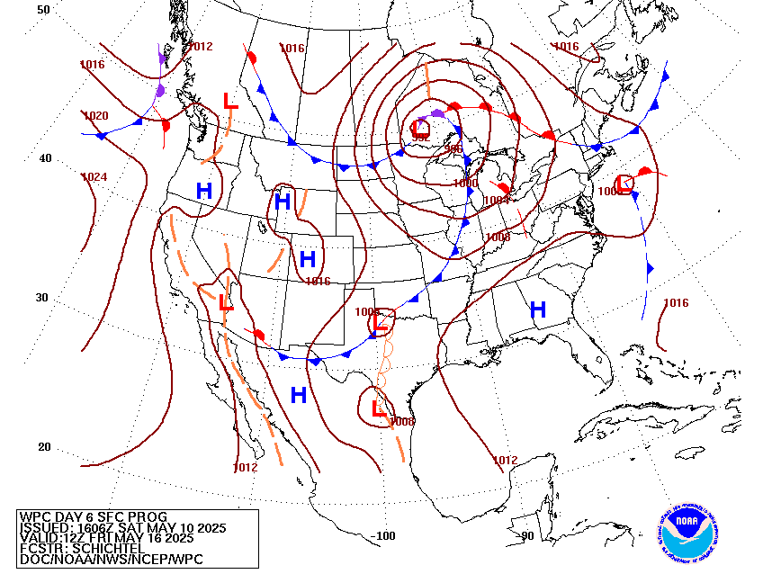
Day 4 image not available
This surface map is valid early Wednesday morning after a cold front moves through (Weather Predictions Center [WPC]). This cold front will be followed by a high pressure system and below normal temperatures.

May Temperature and Precipitation Outlook
As I mentioned before it looks like May will start out slightly below normal. From a new release of the monthly climate prediction from the Climate Prediction Center (CPC), they are predicting around normal temperatures and slightly above average precipitation for the month.

The temperature outlook for the month of May shows near normal temperature for the month of May in Memphis. (NOAA/CPC)

The precipitation outlook for the month of May shows slightly above normal precipitation in Memphis. (NOAA/CPC)

Max Magness
MWN Meteorologist Intern

----
Follow MWN on Facebook and Twitter for routine updates and the latest info!
Complete MWN Forecast: MemphisWeather.net on the mobile web or via the MWN mobile app
Download our iPhone or Android apps, featuring StormWatch+ severe weather alerts!
MWN is a NOAA Weather Ready Nation Ambassador Meteorologist Erik Proseus is an NWA Digital Seal Holder

Wednesday, April 22, 2020

A springtime pattern means several of storms in the next week

Rest of Today into Thursday

A dreary start to our Hump Day. Clouds have been on the increase today as a warm front continues to push north from the Gulf of Mexico. This will turn the winds more southerly giving us a very breezy afternoon with gusts up to 25-30 mph by tonight. Southerly wind will increase our moisture allowing for scattered showers to move in as we head into the evening time.

A low-pressure system will move eastward through the southeast bringing a cold front with showers and storms during the overnight hours. These storms may be on the stronger side with gusty winds, possible hail, and heavy downpours, but thankfully the greatest chance for severe weather will remain to the south of the metro area where more humid and unstable air will reside. Our greatest risk for a strong storm appears to be in the midnight timeframe, plus or minus an hour or two.


Behind the storms, showers will linger into Thursday morning as the low pressure system itself moves over. The additional cloud cover and continued breezy southwest wind will keep our lows fairly warm and muggy in the lower 60s. As the cold front moves on, winds will shift to a more westerly pattern but remain strong with gusts up to 30-35 mph into the afternoon. Throughout the day temperatures will not change much with afternoon highs struggling to reach 70.
Overnight European model data showing a low pressure system moving through the Mid-South Wednesday (4/22) through Thursday (4/23). (PivotalWeather.com) 

Friday

Skies will begin to partially clear and winds will calm Thursday evening. Overnight lows will fall back into the mid-60s. Into Friday, clouds will be on the increase as another system approach from the Plains. Warmer temperatures return to the region with highs in the mid-70s as winds become southerly once more. Showers will be isolated at first Friday afternoon but become increasingly more widespread by Friday evening. Overnight, showers and thunderstorms associate with the second cold front will push through the area. Some of these storms may be on the stronger side producing hail, gusty winds, and heavy downpours. The greatest chance for a strong storm during Friday’s event will be south of the city.

European Model 6:00am run showing a second low pressure system moving through the southeast Friday (4/24) into Saturday (4/23) morning. (PivotalWeather.com)

Saturday thru Monday

Saturday will start off as another dreary day as clouds and isolated showers linger in the morning, however, throughout the day the moisture will move out of the area giving us a mostly dry afternoon. Highs will stay cool struggling to reach 70, but thankfully mostly of us will see at least some sunshine by Saturday afternoon. Overnight lows will be on the chillier side as they fall back down near 50. Sunday looks to be very pleasant with partly cloudy skies and highs continuing to stay cool in the upper 60s. We stay dry with a mix of sun and clouds into Monday with afternoon highs warming back into the lower 70s. If you are planning on doing yard work Sunday and Monday will be your best option!


Tuesday and Wednesday

The models are suggesting that another upper level trough will move through the area early next week initiating yet another round of showers and thunderstorms. They are struggling to come into agreement over when exactly it will come through, but Tuesday into Wednesday seems to be our best chance. Clouds and rain chances will increase throughout Tuesday bringing more heavy rain and gusty winds. Tuesday afternoon will be warm and muggy with highs warming back into the mid-70s. Most of the shower and storm activity should move out of the area early Wednesday morning giving us a mostly pleasant afternoon with decreasing clouds and highs in the mid-70s.

The European model showing temperatures and wind from Monday (4/27)  night at midnight through Wednesday (4/29) night at midnight. (PivotalWeather.com)

Allison Paige
MWN Meteorologist Intern

----
Follow MWN on Facebook and Twitter for routine updates and the latest info!
Complete MWN Forecast: MemphisWeather.net on the mobile web or via the MWN mobile app
Download our iPhone or Android apps, featuring StormWatch+ severe weather alerts!
MWN is a NOAA Weather Ready Nation Ambassador Meteorologist Erik Proseus is an NWA Digital Seal Holder

Tuesday, April 14, 2020

Cold weather moderates this week as rain chances increase this weekend

We experienced a wide variety of weather over the past week! Daily high temperatures varied from the low 80s to the upper 50s. We did see quite a bit of rain Sunday, from multiple rounds of rain and storms, particularly a lengthy period of heavy rain during the late morning and early afternoon hours. The total rain received on Sunday was 2.60". It didn't break the daily record, but the amount was well above average.

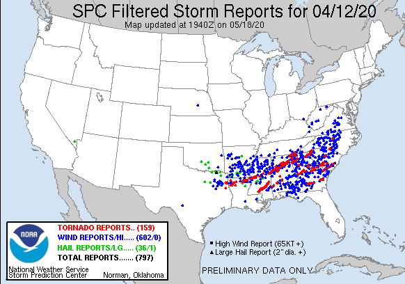
Thankfully we missed the worst of the storms as parts of Louisiana, Mississippi, Alabama, southeast Tennessee, Georgia, and North Carolina saw all types of severe weather. There have been a total of 651 storm reports received by the NWS. There was a truly devastating tornado in Southern Mississippi with the worst of the damage being in Bassfield, MS. This tornado has been given a preliminary rating of an EF-4 with maximum wind gusts of 170 mph! If you would like to look at the damage it caused, here is a link to drone footage.


200412_rpts Filtered Reports Graphic
These are the filtered storm reports from the SPC from 4/12/2020.
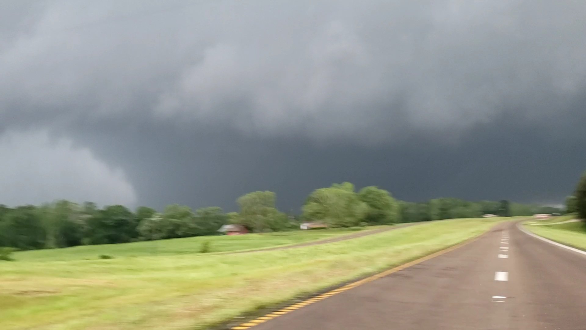
Image
This is the tornado near Soso, MS (in southern MS). Photo credit: Connor McCrorey (@ConnorWX). This is a direct link to the tweet: https://twitter.com/ConnorWX/status/1249456589712633858.
Tuesday Night
The clouds will move out making for a clear and cold night. Much of the Memphis metro is under a Frost Advisory as temperatures are expected to drop into the mid 30s. A Freeze Warning is in effect for Tipton and Fayette Counties, as those areas have the highest probability of temperatures dropping as  low as 30 degrees. Bring in those tender plants or cover them up!


Wednesday
After a very cold early morning, we should be in store for a pleasant Wednesday. Temperatures are expected to rise to the low 60s with sunny skies. Winds during the day should be from the southwest at about 7 mph. Wednesday night into Thursday temperatures are expected to drop to around 40 under a clear sky. Some patchy frost is possible in rural areas.


The GFS model shows why temperatures are so cold right now. Anomalously low pressure aloft over much of the nation means cold polar air is in place at that level. Those blues, purples, and greens are showing that the pressure at 500mb (18,000') is much lower then normal. (WxBell)

Thursday and Friday

Thursday temperatures will top out around 70 under sunny skies. The breeze will be out of the south at about 10 mph. Overnight temperatures will drop to the upper 40s as some cloud cover moves in. On Friday, conditions should be partly sunny with temps in the lower 70s. There is also a slight chance of rain, but it shouldn't cause any real issues. Friday night temperatures will drop into the upper 40s with a slightly better chance of a rain shower.

Saturday and Sunday

Saturday temps will top out in the upper 60s under partly sunny skies. There also still a chance for a lingering shower. Saturday night the chance of rain will increase with scattered showers possible. Sunday will be pretty similar to Saturday. Sunday temperatures will top out around 70 under mostly cloudy skies. There is a continued chance of showers, though no washouts are currently forecast for the weekend. Sunday night lows will drop to around 50 with clouds clearing a little, making for a partly cloudy night.

Monday and Tuesday

The warming trend continues with Monday's highs in the low 70s under partly cloudy skies. Overnight temperatures will drop to the lower 50s. Tuesday temperature will top out in the mid 70s under partly sunny skies.

A Look at Next Week
Using the projections from the Climate Prediction Center (CPC) it looks like temperatures will probably be near normal and precipitation will probably slightly above normal. We'll be watching the mid-week period for our next round of storms.

Latest 6 to 10 Day Temperature Outlook
These are the probabilistic chances of temperatures being above or below normal across the United States (CPC).
Latest 6 to 10 Day Precipitation Outlook
These are the probabilistic chances of precipitation being above or below normal across the United States (CPC).

Max Magness
MWN Meteorologist Intern

----
Follow MWN on Facebook and Twitter for routine updates and the latest info!
Complete MWN Forecast: MemphisWeather.net on the mobile web or via the MWN mobile app
Download our iPhone or Android apps, featuring StormWatch+ severe weather alerts!
MWN is a NOAA Weather Ready Nation Ambassador Meteorologist Erik Proseus is an NWA Digital Seal Holder

Monday, April 13, 2020

March 2020 Climate Data for Memphis, TN

March Climate Recap

Spring began with continued warm and wet weather in March after a similar winter season. In fact, only nine of the 31 days in March were below average, including multiple days in the last week of the month in the 80s. The monthly average temperature ended 4.5 degrees above normal, or 14th warmest on record. As far as precipitation, rainfall totaled over nine inches for the month, or 13th wettest on record. From the 9th through the 24th, a period of 16 days, measurable rainfall occurred on 14 of those days. In fact, 20 days of the month were rain days, tying the record set way back in 1897.

Severe weather occurred on the evening of March 28 with multiple wind damage reports in Shelby County, mainly trees down.

Average temperature anomaly (departure from average) for the month of March 2020 (Data: PRISM. Graphic: WxBell)

Memphis International Airport, Memphis, TN


Temperature
Average temperature: 58.5 degrees (4.5 degrees above average)
Average high temperature: 66.8 degrees (2.9 degrees above average)
Average low temperature: 50.2 degrees (6.1 degrees above average)
Warmest temperature: 85 degrees (26th)
Coolest temperature: 36 degrees (7th)
Heating Degrees Days: 227 (131 below average)
Cooling Degree Days: 31 (14 above average)
Records set or tied: None
Comments: The temperatures never fell below freezing. On average, three mornings reach the freezing mark in a typical March.

Precipitation
Monthly total: 9.41" (4.25" above average)
Days with measurable precipitation: 20 (5.8 days above average)
Wettest 24-hour period: 1.41" (14th)
Snowfall: None (0.4" below average)
Records set or tied: Number of days with measurable precipitation (20) ties the March record (1897)
Comments: For the period January 1-March 31, Memphis recorded measurable rainfall on 51 days of a possible 91, missing the record of 52 days set in 1882. The next highest figure that occurred in the twentieth or twenty-first centuries was 41 days which occurred just two years ago (2018).

Miscellaneous
Peak wind: South/41 mph (1st)
Average wind: 9.5 mph
Average relative humidity: 72%
Average sky cover: 80%

Click here for a daily statistical recap for Memphis International Airport.

Cirrus Weather Solutions / MemphisWeather.net, Bartlett, TN


Temperature
Average temperature: 57.3 degrees
Average high temperature: 66.2 degrees
Average low temperature: 48.7 degrees
Warmest temperature: 87.1 degrees (26th)
Coolest temperature: 29.7 degrees (7th)
Comments: None

Precipitation
Monthly total: 8.34" (automated rain gauge), 9.60" (manual CoCoRaHS rain gauge)
Days with measurable precipitation: 21
Wettest date: 1.04" (14th) (via automated gauge)
Snowfall: None
Comments: Rain fell on 14 of 15 days between the 9th - 24th and 12 consecutive days from the 9th - 20th.

Miscellaneous
Peak wind: South/30 mph (1st)
Average relative humidity: 79%
Average barometric pressure: 30.07 in. Hg
Comments: None

Click here for a daily statistical recap for Bartlett, TN.

MWN Forecast Accuracy

MWN average temperature error: 2.66 degrees
MWN forecast temperatures within 2 degrees of actual: 52%
MWN average dewpoint error: 2.54 degrees
MWN forecast dewpoints within 2 degrees of actual: 60%

MWN's forecasts extend out five periods (2.5 days, or roughly 60 hours). Historical accuracy statistics can be found here.

Climate Outlook - April 2020

The April climate outlook for the United States from the Climate Prediction Center is shown below. Above average temperatures are again forecast for the eastern half of the U.S., with highest odds across the Deep South and Gulf Coast. Below average temperatures are expected in the northwestern quarter of the U.S. Odds favor above average temperatures for Memphis, at 48% (versus only a 19% chance of below average temperatures). Memphis averages 62.9 degrees for the month.


Wetter than normal weather is expected across the southeast U.S. into the eastern Plains, and north into the Upper Midwest. In addition, the western U.S. is expected to be wetter than average. For Memphis, odds favor above average rainfall, at a 45% chance, versus just a 22% chance of below normal precipitation. Memphis historically averages 5.50 inches in April, the second wettest month of the year.

----
Follow MWN on Facebook and Twitter for routine updates and the latest info!
Complete MWN Forecast: MemphisWeather.net on the mobile web or via the MWN mobile app
Download our iPhone or Android apps, featuring StormWatch+ severe weather alerts!
MWN is a NOAA Weather Ready Nation Ambassador Meteorologist Erik Proseus is an NWA Digital Seal Holder

Saturday, April 11, 2020

Easter Sunday severe weather potential - prepare today

UPDATED: 5:30pm Saturday, April 11, 2020

Severe weather season is clearly underway and we are facing another threat of severe storms on Sunday. While beautiful weather is in place today, and a cool, dry airmass returns for Monday and much of next week, Mother Nature has other plans for tomorrow.

Overview

Southerly wind and increasing high clouds today is a harbinger of the developing storm system to our west. As upper level energy moves across the southern U.S. the next 36 hours or so, it will tap into a well of deep moisture in the Gulf of Mexico that is pulled north into the southern U.S. ahead of it's arrival. Surface low pressure will also form and strengthen as it takes a track from the southern Plains northeast across AR and into the Ohio Valley on Sunday. With very strong wind energy at all levels of the atmosphere tomorrow, and given the moisture source and unstable air moving into the region, the stage is set for what could be an outbreak of severe storms.

Tornadoes appear likely and could be violent and potentially long-track during the afternoon and evening to early overnight hours. Fortunately the highest threat for these, as of Saturday morning, is to our south across MS and AL. However, the track of the low pressure system will dictate how far north the most unstable air reaches. We will be watching carefully for any adjustments to that track that could cause the more unstable air to reach the Memphis metro. The most likely scenario locally is scattered strong to severe storms during the afternoon and a squall line during the evening hours. Let's dive into the details.


Timing the rounds of storms

As of Saturday morning, I expect multiple rounds of thunderstorms on Sunday with increasing severe weather chances as the day goes on. Scattered thunderstorm potential exists between each of these as well. This could change!

  • Morning hours (~5am-10am) - Mostly "garden variety" lightning and thunder in scattered storms. Some hail is possible in these as well.
  • Early afternoon (~11am-3pm) - Showers likely with embedded thunderstorms. Again the threat of severe is pretty low, but a brief wind gust or hail threat exists. Additional scattered storms are possible after this round and before the main event.
  • Late afternoon/evening (~6pm-11pm) - This is when our highest threat exists. All modes of severe weather will be possible. The most likely scenario is a broken/solid squall line, or QLCS (quasi-linear convective system), capable of widespread wind damage, hail, and potentially tornadoes. If the squall line is well formed (unknown), the wind damage threat is higher than the tornado threat, though a few could spin up in the line. If the storm cells are maintaining their own identities (supercells not yet formed into a line), then the tornado threat increases.

The 7am run of the high-resolution NAM3 model, showing forecast radar from midnight Saturday night through 6am Monday. THIS IS A MODEL REPRESENTATION AND IS LIKELY TO CHANGE. (WxBell)

Threats

  • Damaging wind is my biggest concern. High wind could be widespread with gusts reaching 70+ mph. Power outages are likely somewhere in the metro. 
  • Tornadoes are possible. While the greatest threat for violent, long-track tornadoes currently exists to our south, some of the key dynamics could be in play over the metro in the evening as well. These could be in the form of spin-ups within the squall line or supercells just ahead of the line in the afternoon. Prepare for the potential!
  • Large hail is also possible in the strongest storms. In fact, small hail could occur in the early morning hours when the initial wave of thunderstorms along the warm front lifts north. The greater threat for large hail is in the evening hours.
  • Very heavy rain is also likely with ponding of water expected and potential flash flooding in poor drainage and urban areas that are particularly susceptible.

*UPDATED* Severe weather probabilities for Sunday's event, within 25 miles of you. The black hatched area in the hail panel indicates a 10% probability of hail 2" or larger occurring. The black hatched area in the tornado panel indicates a 10% probability of EF-2+ tornadoes occurring. (NOAA/SPC)

Boom/bust potential

While the synoptic setup is favorable for an outbreak of severe weather, the details are still TBD and will depend on very small ("storm-scale") features that cannot be predicted much in advance. If the track of the low pressure system moves by a bit further to our north, the metro is more likely to get into highly unstable air and the threat increases. If it tracks a little further south, the best tornado-making ingredients remain suppressed to our south, but we're still left with a threat of high wind and hail. Those small-scale features, combined with the ultimate track of the low, will define what actually happens. There is no reasonable scenario where this all just "goes away." There ARE reasonable scenarios that include strong but not widespread severe, storms, as well as a more potent airmass capable of dropping strong tornadoes getting as far north as the metro. Prepare for the worst, hope and pray for the best!


Preparedness

Know your plan based on the provided timing and where you will be. Where is your safe place and is it ready? The graphic below will help in this regard and applies equally to high wind as well as tornadoes. Also use the severe weather safety tips below to ensure you have the essential items in your safe place with you. And if you do not have sturdy shelter (i.e. if you live in a mobile home or the upper floors in a multi-story dwelling), know where you will go beforehand and make plans to get there when a Tornado Watch is issued, not when the warning comes out and you don't have time to act.


Garage your vehicles if able Sunday afternoon and evening to protect from hail and high wind.

Secure anything outdoors that you wish to keep. Even outside of storms, wind could gust to 30+ mph.

Make sure storm drains are clear to reduce the chances of flash flooding.


Have multiple ways of getting warning information. NOAA Weather Radio is great. Severe weather apps are also great*, including SW+ Alerts in our very own MemphisWeather.net app, available in your app store. Social media is good too, but likely won't be as timely unless you are continuously updating your favorite source's feed (ours are linked at the bottom of this post and our Twitter feed is best for regular, timely updates). And of course keep the TV on for local coverage. Sirens are not good but they won't warn you of large hail or high wind, and they likely can't be hear by most people who are asleep in a well-insulated home.

* Note that most severe weather apps, including MWN, and also Wireless Emergency Alerts require that you have your volume ON and Do Not Disturb OFF to get audio alerts that you can actually hear. Here's more on how to configure your settings for SW+ Alerts, available in the MWN app.


Dealing with stress

Finally, a note to those who suffer from storm anxiety, perhaps moreso due to the other non-related "stressers" factored in these days. I have found it best to combat anxiety with information, facts, and preparation, even in situations we cannot control. If the "hype" posts on social media are bothering you, shut them down. Stick to those who tell it straight without hype and that you trust for factual information. We hope to be one of those, but there are several in our area that are excellent. Follow @NWSMemphis for the source of most of the data we use and fact-based information. In addition, prepare ahead of time so that you know that you'll be ready if you have to act. Follow the steps above!

The last thing I will say is, even if there is a "tornado outbreak" (God forbid), the facts are that the vast majority of the area is untouched and the vast majority of tornadoes are survivable if you are properly-sheltered. The odds are in our favor! So take a deep breath, or several, follow accurate and reliable sources, stick to facts, and be prepared should you need to act.

After this passes, much cooler weather again moves in for a good part of next week before the next storm system moves onto our radar next weekend.

Stay safe and be prepared, not scared!

Further updates will most likely be posted straight to our social media feeds. Please check there often, particularly Sunday, for the latest information.

Erik Proseus
MWN Meteorologist

----
Follow MWN on Facebook and Twitter for routine updates and the latest info!
Complete MWN Forecast: MemphisWeather.net on the mobile web or via the MWN mobile app
Download our iPhone or Android apps, featuring StormWatch+ severe weather alerts!
MWN is a NOAA Weather Ready Nation Ambassador Meteorologist Erik Proseus is an NWA Digital Seal Holder

Wednesday, April 8, 2020

Enhanced Risk: details on our severe weather threat tonight

I'll excuse you given the current circumstances if you have not stepped foot outside yet this morning, but my gosh is it sticky! With dewpoints near 70 and temperatures already crossing the 80 degree mark at noon as the sun starts peeking out, it's feeling like early summer.

What if I told you that tomorrow afternoon will be about 20 degrees cooler with the humidity long gone and a northerly breeze? You might rejoice, but also think, "something must be happening between now and then to cause that...?" And you'd be right - that something would be a potent cold front arriving around midnight tonight.


Given the conditions ahead of the front, and the potency of the front itself, it's not surprising that thunderstorms are thus expected. A few other contributors make this event into one with potentially higher severe chances. Very cold air aloft is moving in, which contributes to the instability but also to ice formation aloft (=> hail below). Also, wind energy is pretty stout as well. Taken together, we have been placed under a Level 3 (of 5) threat for severe weather, an Enhanced Risk, by the Storm Prediction Center.


How it should play out

Storms will form well to our north near the Ohio River and likely become severe. As the front pushes quickly south, additional storm development takes place and likely congeals into a squall line or multiple line segments as it nears the metro. If there are multiple lines, they likely consolidate by the time it pushes into north MS and exits the area.

Timing

Approximately 10pm-1am. The storms likely enter the northern metro around 10pm, move through the city in the 11pm hour, then cross the state line and exit the metro after midnight. All times are +/- an hour or so. It'll be quick-hitting as the storms will be fairly progressive in their motion, if not their politics. You may experience less than 30 minutes of heavy rain and other impacts as it drops south.

Threats

  • Very heavy rain and lightning/thunder.
  • Strong and gusty wind with the potential to briefly exceed 60 mph. 
  • Large hail, like we haven't seen in a long time. The Storm Prediction Center places our area in a "hatched" zone, meaning there is a 10% chance of hail to 2" in size.
  • Isolated tornado. The threat is pretty low, especially if the line is fully formed as it moves through. However, if we see any renegade storm cells that don't want to get in line, the threat goes up a bit.

Severe weather probabilities for tonight's event, within 25 miles of you. The black hatched area in the hail panel indicates a 10% probability of hail stones 2" or larger occurring. (NOAA/SPC)

Boom/bust potential

The forecast timing seems fairly cut and dry, but there is still a potential bust scenario (which for people rooting against severe storms is actually a good thing). One of our "trusted models," the HRRR, runs every hour and has yet to move a line through the metro. It keeps the bad stuff just north and east of us. It's cousin, the NAM3 model, only runs four times a day, but the last couple of runs hit us pretty good with a squall line. Given the ambient conditions ahead of the front, I unfortunately side with the latter. Other less-high-res models agree too. But don't be shocked (and do be pleased!) if this thing misses us entirely. Thus, our severe threat is CONDITIONAL on storms actually moving through the metro. If they do, they're likely to be strong.

The 10am run of the HRRR model showing simulated radar data from 3pm-4am indicates that the main line will just miss us to the northeast. It's been consistent with this trend and is good news. (WxBell)

The 7am run of the NAM3 model showing simulated radar data for the same timeframe indicates that the main line will move right over us. It's also been consistent with this trend and is not as great news. (WxBell)

Preparedness

Garage your vehicles if able when the sun goes down tonight. Tie down anything outdoors that weighs less than a small child and which you wish to keep. Make sure storm drains are clear of the crap that is falling from the trees. If it's garbage day tomorrow, take the trash can out in the morning lest your neighbors shake their fists at you when your trash is all over their yard.


Finally, in all seriousness, have multiple ways of getting warning information tonight. If you're not staying up, they need to be the type to wake you up. NOAA Weather Radio is great. Severe weather apps are great*, including SW+ Alerts in our very own MemphisWeather.net app, available in the App Store. Social media is fine too, but likely won't be as timely and storms will be moving quick tonight. Not recommended unless you are following the right people and continuously updating your feed. (Our Twitter feed will be a good source!) And of course, since it won't go deep into the night, you can always stay up and keep the TV on. Sirens are not good - they won't warn you of large hail or high wind, and they likely can't be hear by most people who are asleep in a well-insulated home.

* Note that most severe weather apps, including MWN, and also Wireless Emergency Alerts require that you have your volume ON and Do Not Disturb OFF to get audio alerts that you can actually hear. Here's more on how to configure your settings for SW+ Alerts, available in the MWN app.


After this passes, much cooler but not unpleasant weather is expected for a few days. Then, we'll be watching Easter Sunday like a hawk. It holds our next potential for severe weather. Then more unusually cool weather.

Erik Proseus
MWN Meteorologist

----
Follow MWN on Facebook and Twitter for routine updates and the latest info!
Complete MWN Forecast: MemphisWeather.net on the mobile web or via the MWN mobile app
Download our iPhone or Android apps, featuring StormWatch+ severe weather alerts!
MWN is a NOAA Weather Ready Nation Ambassador Meteorologist Erik Proseus is an NWA Digital Seal Holder

Monday, April 6, 2020

Rain chances mid-week, followed by a pleasant and dry end of the week

Monday

We are definitely warm this afternoon as a weak ridge situates over the southeast. Temperatures are near 80 in the metro with a mix of sun and clouds in the sky heading into Monday evening. Today turned out to be a truly gorgeous day, but clouds will be on the increase throughout the evening hours. Monday night will be mostly dry with mostly cloudy skies, but an isolated shower is possible especially after midnight. Overnight temperatures continue to stay warm with lows only falling into the mid-60s thanks to a southerly wind.


Visible Satellite Imagery at 2pm showing increasing clouds across the southeast especially over AR, TN, and MS. (COD.edu)

Tuesday

A continued southerly wind will help enhance instability across the region on Tuesday giving us one of our best chances of rain this week. Warm temperatures and increased moisture will aid in forming scattered showers and thunderstorms throughout the afternoon. A few peeks of sunshine are possible early Tuesday, but the majority of the day will consist of mostly cloudy skies. Most of the thunderstorm activity will occur across northern Mississippi and the strong to severe concern for this event will be on the lower end. Afternoon highs will reach close to 80 but will be cut short as showers move through the metro area. Thankfully Tuesday’s event does not look like a washout with totals less than a 0.1 inches and a few dry hours scattered throughout the day. Overnight, temperatures will stay warm with lows only falling into the upper 60s but most of the showers will have moved out of the area.

The European model showing total rainfall across the southeast through Tuesday at Midnight. Totals across the Metro are less than 0.1 (tenth) of an inch. (PivotalWeather.com)

Wednesday

While a southwesterly wind continues into Wednesday, much of the moisture and clouds will move out of the area during the early morning hours. This will leave a very summer-like day for Wednesday. Skies will be mostly sunny with a few clouds but afternoon temperatures will easily warm into the mid-80s. By Wednesday evening clouds will begin to move back into the region as a shortwave trough approaches the area. This will bring our best chance and last chance of rain across the southeast for the next several days and that is something we have not gotten to say a lot!

Wednesday Night Storms

Wednesday night will also bring along a chance for some strong to severe thunderstorms. As temperatures rise throughout the day, dewpoint temperatures will rise accordingly to near 70 degrees. With all the warmth and moisture available, instability will be considerable. As the trough approaches, a squall line of thunderstorms will form and propagate through the region during the evening and overnight hours on Wednesday. April is the peak time for southeastern U.S. tornadoes, and while a few embedded within the line are possible, the main concern with this line will be damaging winds. With strong straight-line winds the biggest cause for concern, a Slight Risk (level 2/5) of severe weather is warranted for most of the metro.

The SPC Convective Outlook for Wednesday night, April 8. (NOAA/SPC)

Thursday and Friday

Behind this trough are much cooler temperatures. According to the Climate Prediction Center’s 8-14 day outlook, a cooler and wetter trend is likely to setup. The models are struggling to agree on how much and when precipitation will occur over the next week. As of now, Thursday and Friday appear to be carbon copies of each other. We will have lots of sunshine with afternoon highs in the low to mid-60s as a high pressure situates over western Tennessee to help end the workweek. Very pleasant and dry weather to get out and enjoy!

Get out and enjoy the great springtime weather Thursday and Friday!

Saturday - Monday

Into the weekend, confidence continues to be thin. According to the European model, the high pressure moves off to our east on Saturday allowing for some widely scattered showers to move through. Some of us may even make it through the day without seeing a shower at all on Saturday. Into Sunday mostly cloudy skies move back into the metro with a few more showers. The GFS and EURO differ considerably here as the GFS shows a dry Saturday and a fairly wet Sunday evening into Monday. The EURO picks up on this precipitation pattern but is much more conservative. The GFS shows more of a widespread pattern moving in later as the EURO shows a mostly scattered setup moving in by lunch on Sunday and out but midnight. Despite the discrepancy in the timing, Monday appears to be a cool, mostly cloudy day with highs in the mid-60s.
This is the GFS model beginning at Midnight Saturday and ending Sunday night at midnight. (PivotalWeather.com)

This is the European model beginning at Midnight Saturday and ending Sunday night at midnight. (PivotalWeather.com)

Allison Paige
MWN Meteorologist Intern

----
Follow MWN on Facebook and Twitter for routine updates and the latest info!
Complete MWN Forecast: MemphisWeather.net on the mobile web or via the MWN mobile app
Download our iPhone or Android apps, featuring StormWatch+ severe weather alerts!
MWN is a NOAA Weather Ready Nation Ambassador Meteorologist Erik Proseus is an NWA Digital Seal Holder