Sunday, January 29, 2023

Sunday evening update on this week's ice potential

This is an update to the blog posted on Saturday

Recent model data, including high-resolution data that now extends out through Tuesday/Wednesday, has trended a bit cooler than previously. For those that were hoping we might miss out on icy conditions in the Memphis metro, it's not necessarily good news. For those hoping for a "snow day" (or ice day), your chances might be increasing. Now we have to hope that significant impacts will be avoided. Let's get right to it.


Monday night/Tuesday morning

There are two time periods of concern for freezing rain in the metro. The first is Monday night/Tuesday morning. Light rain is expected to move in Monday evening with temps falling slowly in the 30s. High-res models have surface temperatures reaching freezing by about midnight with a low around 30 degrees. Precipitation from this first round should move out Tuesday morning shortly after sunrise. While precipitation should be light, it is possible that one-tenth of an inch of ice could accumulate overnight between midnight and mid-morning Tuesday. 


Tuesday night/Wednesday morning

The second round of precipitation arrives sometime Tuesday afternoon or early evening. Highs Tuesday will be in the mid 30s, so it is appearing likely that by evening, we'll once again see the mercury drop to the freezing mark. While some melting of Monday night's light icing will occur in dry and "warmer" conditions Tuesday, additional accumulation appears likely Tuesday night through Wednesday morning, before temperatures once again rise above freezing. Right now, our best guess on when that happens is mid-morning Wednesday. While additional rainfall is likely Wednesday through Thursday, we expect temperatures to remain above the critical 32° point after mid-morning Wednesday. It is possible that round two could bring another 0.10-0.20" of ice. 


The highest potential for seeing total accumulation of one-quarter inch or more are along and north of I-40. Lighter amounts appear likely in northwest MS (DeSoto, Tunica, Marshall Counties). The city of Memphis can expect some minor icing that will likely make travel hazardous both early Tuesday morning and likely Tuesday night into Wednesday. Whether it will be enough to result in tree damage and widespread power outages is to be determined, but scattered power outages seem likely by Wednesday morning. Preparations should be made in the next 24 hours for this potential. 

The Probabilistic Winter Storm Severity Index from the NWS, shown above, shows the probability of "minor" impacts, in this case through Wednesday morning. It feels inevitable that these percentages will increase as we get closer to the event. (NWS)

Also as an FYI, Winter Weather Advisories are issued by the National Weather Service when impacts to travel and commerce are expected within 24-36 hours. Winter Storm Warnings are issued when there is higher confidence in more significant impacts that may necessitate avoiding travel and preparing for more widespread power outages - which equates to at least 1/4" of ice.


Continue to monitor your local weather sources that can interpret the flood of data meteorologists are seeing over the next few days, and be aware of hyperbole or social media shares that seem "extreme." Some model data that is likely to be shared WILL be overblown and unrealistic. Rely on trusted sources that can properly filter the information. We'll keep you posted!

Erik Proseus
MWN Meteorologist

----
Follow MWN on Facebook and Twitter for routine updates and the latest info!
Complete MWN Forecast: MemphisWeather.net on the mobile web or via the MWN mobile app
Download our iPhone or Android apps, featuring StormWatch+ severe weather alerts!
MWN is a NOAA Weather Ready Nation Ambassador Meteorologist Erik Proseus is an NWA Digital Seal Holder

Saturday, January 28, 2023

An active pattern, but this time with cold air mixed in!

A very wet month is about to get wetter before we turn the page to February on Tuesday. Multiple rounds of precipitation have moved through in the past couple of weeks, and looking ahead we've got another wet pattern expected for the next several days, as waves of precipitation move through. This time though, temperatures will be much more critical than recent events!

Round 1 - Saturday night/Sunday

A cold front will move into the Mid-South Sunday, stalling not far to our south by Monday morning. The first round of precip starts today and will drop 1/2" to 3/4" of rain through Sunday morning as an upper level trough precedes the cold front. Rain will be steadiest overnight tonight with a few rumbles of thunder possible in the pre-dawn hours Sunday. In addition, wind will pick up quite a bit and gusts could exceed 30 mph overnight. Temperatures should remain near 50 overnight. 

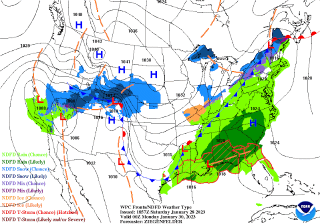
As of Sunday evening, a cold front will be positioned across the metro, sinking a bit further south and ushering in cold air that will be a factor in precipitation type for a few waves of precipitation the first half of the week. (NWS/WPC)

By mid-morning, that batch should move out and we'll be left with cloudy skies and continuing chances of showers, especially in north MS, as the wind subsides and highs top out in the upper 50s. The cold front itself moves through by early evening with another chance of scattered showers, then low clouds and drizzle overnight as temperatures fall into the upper 30s, a bit cooler north of the city. Monday will be an "in-between" day with clouds lingering and temperatures much cooler behind the front, in the mid 40s for highs.

Round 2 - Monday night/Tuesday

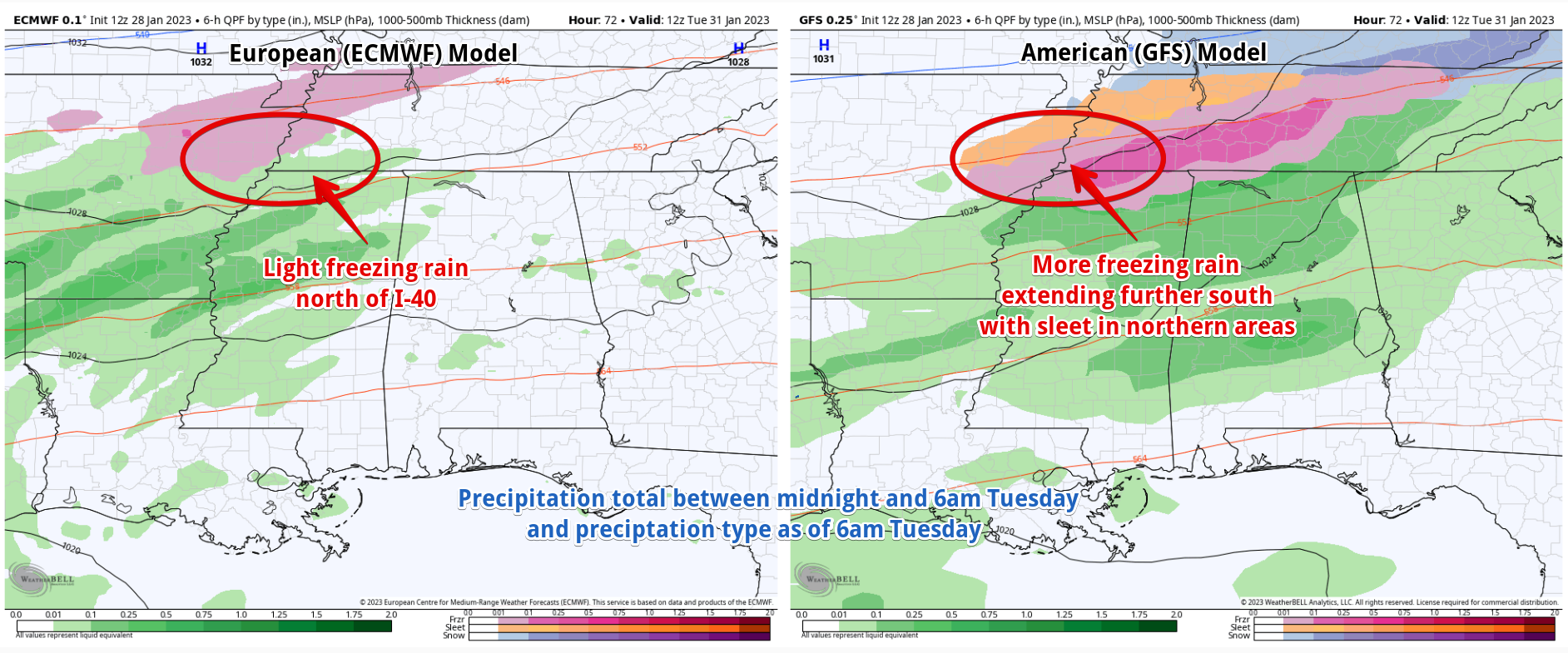
After Monday's lull, and with cold air in place, the next round of precipitation looks to arrive Monday night into Tuesday. This is where our medium-range models start to diverge a bit. The American models that cover that period of time bring in a pretty decent slug of moisture Monday night into early Tuesday, while the trusty European model holds back a bit, with less precipitation and not quite as early of a start Monday evening. However, all of them bring temperatures down to near or at the freezing mark by dawn Tuesday, plus or minus a couple of hours. 

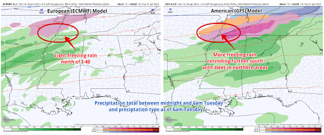
A comparison of the Saturday morning European and American models for Tuesday morning. These are just two possible scenarios and do not represent all potential options. (WeatherBell)

Because the cold air is shallow and there is warm air (above freezing) above the surface during this time (and in fact all week it appears), areas that get down to 32 degrees will receive freezing rain. The most likely place for that to happen is along and north of I-40. Northern sections of the metro (Tipton County) have a higher chance of this occurring than southern sections (north MS). The amount of precipitation that falls at 32 or below is the big question and one the models don't have a good handle on yet. 

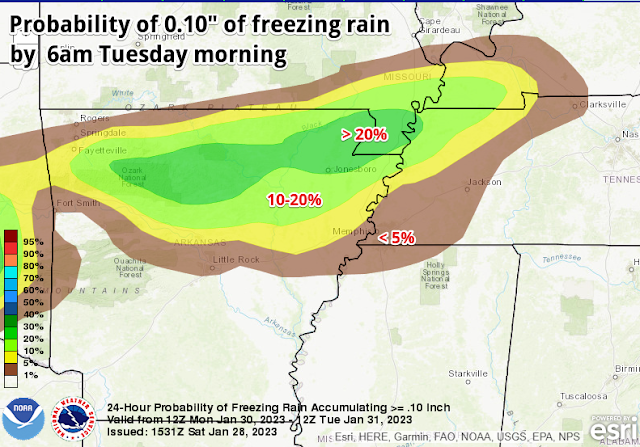
The NWS Weather Prediction Center freezing rain probability forecast shows where the greatest chance of impactful icing is most likely on Monday night into Tuesday, specifically northern AR into northwest TN. (NWS/WPC)

Predicting shallow cold air more than 24-48 hours out is maybe one of the biggest challenges we face and models tend to not do so well at it. One to two degrees will make all the difference. At this point, I am forecasting a chance of light freezing rain, probably less than 0.10" accumulation, for Tuesday morning roughly along and north of I-40 (or Highway 70 in west TN, if you think I-40 is overused as a geographical reference!). Higher amounts are possible well north of the metro.

Round 3 and beyond

The next wave of precipitation may be the most drawn-out, though there could be some breaks the models don't see yet. It starts sometime later Tuesday and could continue through Thursday. For this time period, there are also question marks regarding the thermal profile from onset of precipitation through Wednesday morning. Since we're talking 3-4 days out, it's too early to make any definitive statements, other than to express the uncertainty involved. The European and American medium range models both agree that most areas of the greater metro, particularly south of I-40, should remain above freezing and therefore see cold rain. Just to the north, we still have some concern for northern sections of the metro, especially Tipton Co and going north from there. 

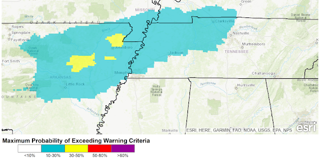
The Weather Prediction Center Winter Storm Outlook depicts the probability of a Winter Storm Warning being required in the extended range, specifically for Tuesday and Tuesday night, in this graphic. Winter Storm Warning criteria is 0.25" of freezing rain. Once again, northeast AR is the most likely area where significant icing is possible, though it does not preclude lighter amounts as far south as the Memphis metro. (NWS/WPC)

Temperatures are likely to be within a couple of degrees of freezing from Tuesday through at least mid-day Wednesday. It could be a miserable cold rain, or ice accumulation that threatens some tree limbs and power lines. Once again, the greatest concern is north of Memphis, and probably north of Shelby County, but we'll have to see what it looks like as we get closer in time. It does appear that the last 24 hours or so of precipitation (mid-day Wednesday through Thursday) should be all rain at this point, as the front lifts a bit north and warmer temps (comparatively speaking) follow. For now I am forecasting 40 degrees for a high Wednesday, mid-30s for a low Thursday morning, and low 40s Thursday afternoon. Cross your fingers!

So to recap: rain this weekend, mainly dry Monday, more rain Monday night and the potential for light icing early Tuesday, more precip starting late Tuesday with a threat of additional icing in the northern metro and points north, then rain Wednesday mid-day through Thursday. Because of warm temperatures aloft, we are NOT looking at a snow event. Colder areas in the far northern metro might see a bit of sleet at times, but freezing rain is the main concern.


We'll have more updates, especially on social media, as the forecast gets refined. The latest forecast from MWN can always be found on our mobile app or website.

Closing remarks from a team member

#TeamMWN intern Jacob Woods has had his last shift with us and will be missed a great deal. Though still a junior at Mississippi State, he has landed his first broadcast meteorology job with WVUA-TV in Tuscaloosa and starts soon. I asked him if he wanted to write a few words. Here they are:

A year full of extreme weather, learning curves, and forecast challenges has made this experience beyond humbling and necessary for my Meteorological career. I can not thank MemphisWeather.net enough for presenting this opportunity to me, allowing me to dive head first into an engaging internship that has expanded my knowledge and conceptual understanding of just how complex this atmosphere really is. Most of all, thank you for giving us younger people a chance to get our feet wet and for trusting our wording and forecasts. One like or share on social media can be a pat on the back, and for myself, this has been the most rewarding internship in my career thus far! It has been a pleasure serving the metro, but it is time to move onto my next chapter...keep it sunny Memphis!

Jacob is knowledgeable, passionate, and a great communicator and will have a phenomenal career in broadcast meteorology. We wish him all the best and thank him for his time with #TeamMWN! 

Joining the team a couple of weeks ago, Dorien Minor is completing his Master's in Atmospheric Sciences at Georgia Tech and will graduate in May. Dorien hails from Maryland and is already making his mark (/DM) on our social feeds. Replacing Jacob will be Carter Bentley, a senior Professional Meteorology major at Mississippi State that also graduates in May. You'll see his social media posts (/CB) in the very near future! 

Erik Proseus
MWN Meteorologist

----
Follow MWN on Facebook and Twitter for routine updates and the latest info!
Complete MWN Forecast: MemphisWeather.net on the mobile web or via the MWN mobile app
Download our iPhone or Android apps, featuring StormWatch+ severe weather alerts!
MWN is a NOAA Weather Ready Nation Ambassador Meteorologist Erik Proseus is an NWA Digital Seal Holder

Saturday, January 14, 2023

2022 Annual Climate Report for Memphis, TN

Memphis International Airport, Memphis, TN


Temperature 
Average temperature: 60.8 degrees (2.6 degrees below average) 
Average high temperature: 71.1 degrees (1.9 degrees below average) 
Average low temperature: 50.6 degrees (3.2 degrees below average) 
Warmest temperature: 103 degrees (July 5th, 8th) 
Coolest temperature: 1 degree (December 23rd) 
Heating Degrees Days: 2774 (101 below average)
Cooling Degree Days: 1740 (574 below average) 

High temperature records set or tied
Warmest highs - January 1 (79), March 3 (82, tied), March 6 (81), May 10 (90, tied), May 11 (92), May 12 (97), May 18 (94), June 16 (100), June 17 (100, tied), June 21 (101, tied), June 22 (102), June 25 (101), July 7 (101, tied), July 8 (103), September 19 (98, tied), September 20 (100, tied), September 21 (102).  Coolest highs - August 17 (77), December 23 (14). The high temperature of 79 degrees on January 1 tied the record for warmest temperature for the month of January.

Low temperature records set or tied
Warmest lowsMarch 6 (66), May 19 (75), June 17 (82). The low temperature of 82 degrees on June 17 set the record for warmest low temperature for the month of June. Coolest lows - None.

Comments: The latest freeze of the year occurred on March 13 and the first freeze in the fall was on November 12, yielding a growing season of 244 days. There were 72 days with high temperatures at or above 90 degrees, which is exactly average for the year, but 18 days that reached at least 100 degrees, which is third most on record. There were four days with high temperatures at or below 32 degrees, which typically only occurs about 3 times per decade. There were 62 days with low temperatures at or below 32 degrees, which is 17.6 above average. June ended up seventh warmest on record and July was 2nd warmest on record, while the summer months of June-August ended fourth warmest. 

Precipitation 
Monthly total: 55.84" (0.90" above average) 
Days with measurable precipitation: 81 (30.4 days below average) 
Days with at least one inch of precipitation: 17 (0.9 days below average) 
Wettest 24-hour period: 2.37" (October 29th) 
Snowfall: 4.2" (1.5" above normal)
Days with measurable snowfall: 5 
Days with any snowfall: 12 (9.4 days above average) 
Daily records set or tied: January 3 (3.84"), February 22 (1.82" - tied), October 29 (2.37"), November 5 (1.61")
Comments: June was the tenth driest on record with only 0.88" of rainfall, kickstarting a lengthy period of drought conditions that continued in the fall.

Miscellaneous 
Peak wind: Southwest/49 mph (February 17th) 
Average wind: 7.7 mph 
Average relative humidity: 64%
Average sky cover: 48%

 Click here for a daily statistical recap for Memphis International Airport.
 

Cirrus Weather Solutions / MemphisWeather.net, Bartlett, TN


Temperature 
Average temperature: 62.7 degrees 
Average high temperature: 74.7 degrees 
Average low temperature: 52.1 degrees 
Warmest temperature: 101.0 degrees (July 8th) 
Coolest temperature: -0.3 degrees (December 23rd) 

Precipitation 
Annual total: 51.95" (automated rain gauge), 54.53" (manual CoCoRaHS rain gauge) 
Days with measurable precipitation: 108
Wettest date: 2.59" (April 19th) (via automated gauge) 
Snowfall: 6.9"

Miscellaneous 
Peak wind: Southwest/38 mph (March 30th)
Average relative humidity: 71% 
Average barometric pressure: 30.06 in. Hg

Click here for a daily statistical recap for Bartlett, TN.
 

MWN Forecast Accuracy

MWN average temperature error: 2.14 degrees 
MWN forecast temperatures within 2 degrees of actual: 66% 
MWN average dewpoint error: 2.24 degrees 
MWN forecast dewpoints within 2 degrees of actual: 65% 

MWN's forecasts extend out five periods (2.5 days, or roughly 60 hours). Historical accuracy statistics can be found here.

--- 
Follow MWN on Facebook and Twitter for routine updates and the latest info! 
Complete MWN Forecast: MemphisWeather.net on the mobile web or via the MWN mobile app 
Download our iPhone or Android apps, featuring StormWatch+ severe weather alerts!
MWN is a NOAA Weather Ready Nation Ambassador Meteorologist Erik Proseus is an NWA Digital Seal Holder


Friday, January 6, 2023

December 2022 Climate Report for Memphis, TN

December Climate Recap

Temperatures for the month of December in Memphis averaged very close to normal with high temperatures about a degree below average, but low temperatures about a degree above average. With a couple of exceptions, most days in the first half of the month were warmer than average with highs in the 50s and 60s and mild overnight lows. The 40s arrived mid-month, followed by a major Arctic blast just before Christmas. This airmass resulted in snowfall and a flash freeze, followed by a few days in which highs were near or below freezing, including a record cool high of 14 degrees on the 23rd.  Warmer weather moved in after the Christmas weekend with highs back in the 60s. 

The temperature anomaly map for the month of December shows below average temperatures across most of the northern US. and above average temperatures for much of the south, with the Mid-South near average. (PRISM temperature data via WeatherModels)

December was a wet month overall, but only totaled about 1/2 inch above normal despite nearly one-half of the days in the month receiving precipitation. Twelve of the first fourteen days of the month had some amount of precipitation, with a total of five inches in two weeks. A drier and cooler pattern set in after that, though the arrival of an Arctic airmass brought precipitation, including 0.5-1.0" of snow to the metro on the 22nd. A couple more wet days preceded New Year's Eve. There was no severe weather during the month.

Memphis International Airport, Memphis, TN

Temperature 
Average temperature: 44.9 degrees (0.1 degrees above average) 
Average high temperature: 52.6 degrees (0.8 degrees below average) 
Average low temperature: 37.1 degrees (0.9 degrees above average) 
Warmest temperature: 72 degrees (6th) 
Coolest temperature: 1 degree (23rd) 
Heating Degrees Days: 619 (9 below average)
Cooling Degree Days: 2 (2 above  average) 
Records set or tied: Daily minimum high temperature (14 degrees on the 23rd)
Comments: Eleven days dropped to 32 degrees or below this month, which is 0.5 days below the average December. Two days did not reach above 32 degrees, which is 1.3 days above normal.

Precipitation 
Monthly total: 5.95" (0.46" above average) 
Days with measurable precipitation: 14 (3.8 days above average) 
Wettest 24-hour period: 2.04" (13th-14th) 
Snowfall: 0.5" (0.3" above normal)
Records set or tied: None
Comments: 0.5" of snow fell on the 22nd

Miscellaneous 
Peak wind: Northwest/44 mph (22nd) 
Average wind: 7.9 mph 
Average relative humidity: 74%
Average sky cover: 67%

 Click here for a daily statistical recap for Memphis International Airport.
 

Cirrus Weather Solutions / MemphisWeather.net, Bartlett, TN

Temperature 
Average temperature: 43.9 degrees 
Average high temperature: 51.7 degrees 
Average low temperature: 35.0  degrees 
Warmest temperature: 71.1 degrees (6th) 
Coolest temperature: -0.3 degrees (23rd) 
Comments: None 

Precipitation 
Monthly total: 6.33" (automated rain gauge), 6.25" (manual CoCoRaHS rain gauge) 
Days with measurable precipitation: 15
Wettest date: 1.19" (13th) (via automated gauge) 
Snowfall: 0.8" (0.7" on 22nd, 0.1" on 26th)
Comments: None

Miscellaneous 
Peak wind: West/27 mph (22nd)
Average relative humidity: 80% 
Average barometric pressure: 30.15 in. Hg
Comments: None

Click here for a daily statistical recap for Bartlett, TN.
 

MWN Forecast Accuracy

MWN average temperature error: 2.69 degrees 
MWN forecast temperatures within 2 degrees of actual: 57% 
MWN average dewpoint error: 2.53 degrees 
MWN forecast dewpoints within 2 degrees of actual: 55% 

MWN's forecasts extend out five periods (2.5 days, or roughly 60 hours). Historical accuracy statistics can be found here.

--- 
Follow MWN on Facebook and Twitter for routine updates and the latest info! 
Complete MWN Forecast: MemphisWeather.net on the mobile web or via the MWN mobile app 
Download our iPhone or Android apps, featuring StormWatch+ severe weather alerts!
MWN is a NOAA Weather Ready Nation Ambassador Meteorologist Erik Proseus is an NWA Digital Seal Holder


Sunday, January 1, 2023

Severe Weather Briefing (VIDEO) - Storms expected Monday afternoon into Monday night

MWN meteorologist Erik Proseus reviews the potential for severe weather on January 2-3, 2023, including threats from two waves of storms, timing, and safety and preparation information. Graphics used in the video are shown below. 

Stay with us on Facebook and Twitter for the latest information, as well as routine updates during the storms.


Erik Proseus
MWN Meteorologist

----
Follow MWN on Facebook and Twitter for routine updates and the latest info!
Complete MWN Forecast: MemphisWeather.net on the mobile web or via the MWN mobile app
Download our iPhone or Android apps, featuring StormWatch+ severe weather alerts!
MWN is a NOAA Weather Ready Nation Ambassador Meteorologist Erik Proseus is an NWA Digital Seal Holder