Saturday, February 19, 2022

A beautiful weekend leads to another wet and stormy week; details on TN Severe Weather Awareness Week

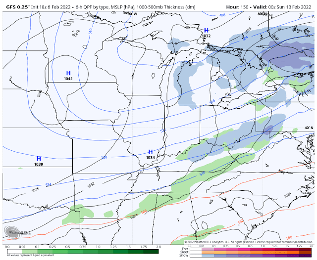
A couple of weeks ago, it was an ice storm causing meteorological chaos across the metro. This past week we dealt with the spring version of inclement weather - strong to severe thunderstorms - though fortunately the tornado threat did not materialize in our area. A chilly post-frontal Friday has led into improving conditions this weekend, but more rain and storms are on tap for next week. 

A pleasant weekend

An abundance of sunshine and wind becoming southerly by Sunday will help move the mercury in the thermometer the next couple days, as we reach 50 degrees today with that northerly breeze, but easily eclipse 60 tomorrow when it turns to the south. A great weekend for getting outside and doing some cleanup or prep for spring! It's not too far off! Those wind gusts on Sunday will be between 20-30 mph. 

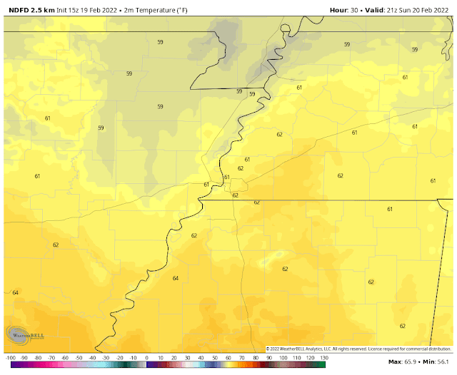
Sunday mid-afternoon temperatures according to the National Weather Service. (NDFD via WeatherBell)

Early week turns wet and stormy

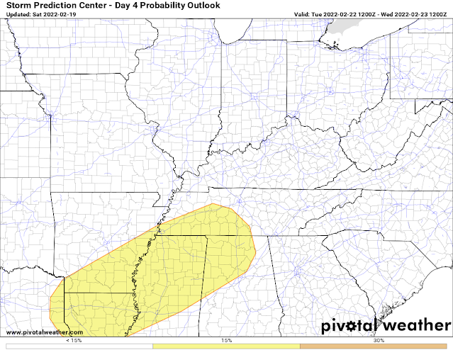
By Monday, the south wind will bring in increasing moisture and scattered showers are likely to break out to start the work week. The wind and moisture will make for mild conditions as well though, with a low near 50 degrees Monday morning and highs again in the mid 60s. A few thunderstorms could also erupt by afternoon. The Storm Prediction Center currently has areas west of the Mississippi River in a Level 2 Slight Risk of severe storms Monday afternoon/night while an accompanying Level 1 Marginal Risk is in place east of the river, including the Memphis metro. The main threats, again in AR, are scattered strong wind gusts and possibly some hail. Rain could be locally heavy as well, especially overnight.

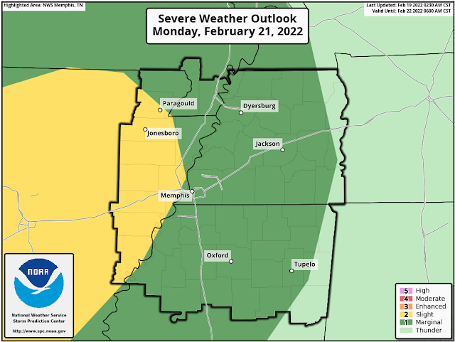
The severe weather outlook from the Storm Prediction Center for Monday and Monday night includes a level 2 risk in AR and a level 1 risk for the majority of the metro. Damaging wind and some hail are the main threats, especially west of the river. (NWS/SPC)

By Tuesday, a cold front approaches the area. With plenty of wind energy in place and some unstable air, the threat of severe weather shifts into the metro. In addition, atmospheric moisture content will be ultra-high. Coupled with a slow-moving front, heavy rainfall will be more widespread. So the main threats on Tuesday will be flooding of low lying areas and tributaries to the local river system, as well as scattered damaging wind gusts. With a good deal of wind throughout the lower atmosphere, the tornado threat cannot be ruled out, but is very low. Tuesday morning lows will be a balmy 60 degrees with highs near 70.

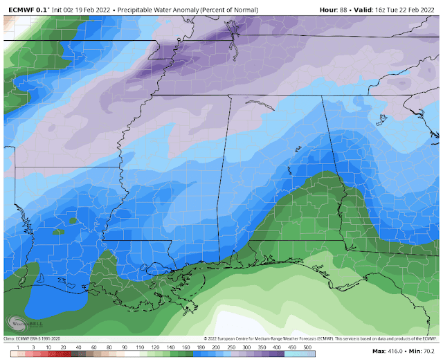
Precipitable water values (which are a measure of total atmospheric moisture in a column of air) forecast by the European model will be 300-400% of normal on Tuesday - a sure sign that rain will be heavy and flooding will need to be monitored. (WeatherBell)

The Storm Prediction Center has a level 2 risk of severe storms for most of the metro on Tuesday. Damaging wind is the main threat with a very small risk of a tornado. (SPC via Pivotal Weather)

Storm system #2 arrives mid-week

The front moves through Tuesday night and we start to dry out for a minute. Temperatures cool down into the mid 30s by Wednesday morning and reach 50 degrees in the afternoon for the high. Unfortunately, southwesterly flow aloft means moisture continues to feed into the area and it appears by Wednesday evening at the latest, we're back in a wet pattern. 

On Thursday, another front approaches the region, this one with additional wind energy and plenty of moisture in place. For now, the severe weather threat appears fairly low, but that could change, so you need to keep an eye on the forecast. In any event, rain could again be periodically heavy. By the end of the week, we could be looking at multiple inches of rain over a four-day window from Monday-Thursday. Rivers are likely to run higher and the threat of flooding will be higher Thursday with any heavy downpours due to saturated ground from Tuesday. Heading into next weekend, cooler and drier conditions look to prevail, not unlike this weekend. Hey, at least the weekends are decent! 

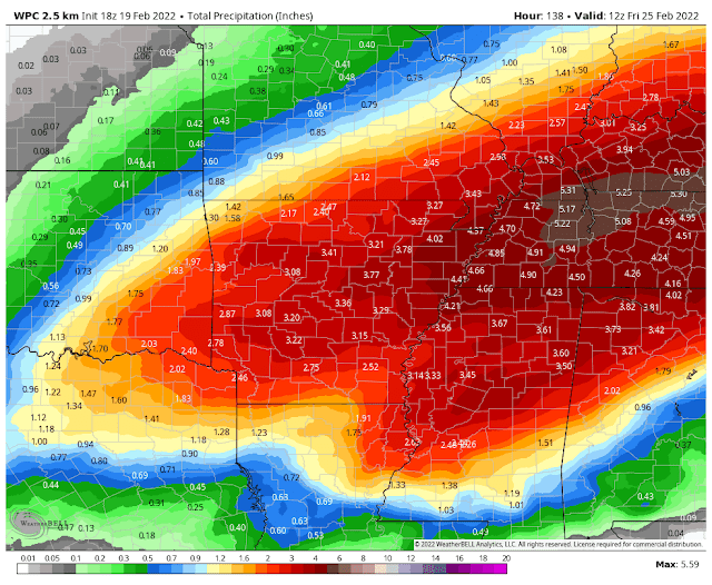
The NWS Weather Prediction Center forecasts 4-5" of rain across the metro this week. Make sure the storm drains and gutters are clean! (WNOAA/WPC)


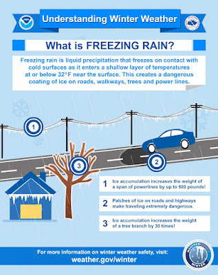
This week is also Severe Weather Awareness Week in Tennessee. Look for tips and safety information from us and the National Weather Service all week long on social media. You can also visit the SWAW website for the state of Tennessee by clicking here to learn more about the daily topics that will be covered, online spotter classes, and more! We're closing in quickly on our peak severe weather season, as evidenced by the wild weather swings of the past few weeks and increasing temperatures between them, which will only add more storm fuel to the equation as we get deeper into March and April.

Erik Proseus
MWN Meteorologist

----
Follow MWN on Facebook and Twitter for routine updates and the latest info!
Complete MWN Forecast: MemphisWeather.net on the mobile web or via the MWN mobile app
Download our iPhone or Android apps, featuring StormWatch+ severe weather alerts!
MWN is a NOAA Weather Ready Nation Ambassador Meteorologist Erik Proseus is an NWA Digital Seal Holder

Tuesday, February 15, 2022

Strong wind and a few severe storms in the forecast

I recorded a video discussion this evening covering the inclement weather expected over the next 48 hours. That video is below, along with a few of the pertinent slides. Prepare for wind gusts to 30 mph and dry conditions on Wednesday, then a rainy Thursday with the potential for a few severe storms Thursday (mainly afternoon) and non-thunderstorm wind gusts to 40 mph. My main concern is trees and branches loosened by the previous ice storm breaking loose or falling, resulting in additional power outages.


Follow us on social media and download our free app for continuous coverage. Links below. Stay safe!

Erik Proseus
MWN Meteorologist

----
Follow MWN on Facebook and Twitter for routine updates and the latest info!
Complete MWN Forecast: MemphisWeather.net on the mobile web or via the MWN mobile app
Download our iPhone or Android apps, featuring StormWatch+ severe weather alerts!
MWN is a NOAA Weather Ready Nation Ambassador Meteorologist Erik Proseus is an NWA Digital Seal Holder

Friday, February 11, 2022

January 2022 Climate Report for Memphis, TN

January Climate Recap

Following the second warmest December on record, the "heat" broke on January 2 after a record warm New Year's Day that topped out at 79 degrees. Temperatures roller-coastered throughout the month but ended up nearly 2 degrees below normal. Twenty-three days recorded below freezing low temperatures while nine days had high temperatures of 60 or greater. Precipitation finished just below average for the month while snowfall totaled 1.7 inches, spread over three days with measurable snow. The heaviest snow event occurred on the 16th with totals in the city between 1-2 inches, but 2-4 inch amounts reported in the greater metro east of Memphis.

Thunderstorms on the 1st dropped over an inch of rain and shifted the pattern from December warmth to a much cooler January.  Those storms were also responsible for minor tree and power line damage across the metro with a 68 mph wind gust recorded at the Millington Regional Jetport.

Memphis International Airport, Memphis, TN

Temperature 
Average temperature: 40.3 degrees (1.8 degrees below average) 
Average high temperature: 51.5 degrees (0.6 degrees above average) 
Average low temperature: 29.0 degrees (4.3 degrees below average) 
Warmest temperature: 79 degrees (1st) 
Coolest temperature: 17 degrees (21st) 
Heating Degrees Days: 759 (49 above average)
Cooling Degree Days: 0 (1 below average) 
Records set or tied Record high temperature - 79 degrees (1st)
Comments: 23 days saw temperatures fall below freezing which is 8.1 above average

Precipitation 
Monthly total: 3.81" (0.33" below average) 
Days with measurable precipitation: 7 (3.0 days below average) 
Wettest 24-hour period: 1.27" (1st) 
Snowfall: 1.7" (0.8" above average)
Records set or tied: Tied record daily snowfall - 0.3" (2nd)
Comments: Three days recorded measurable snowfall with a maximum of 1.2" on the 16th.

Miscellaneous 
Peak wind: South/39 mph (1st) 
Average wind: 8.9 mph 
Average relative humidity: 60% 
Average sky cover: 50%

 Click here for a daily statistical recap for Memphis International Airport.
 

Cirrus Weather Solutions / MemphisWeather.net, Bartlett, TN

Temperature 
Average temperature: 37.6 degrees 
Average high temperature: 49.6 degrees 
Average low temperature: 26.4 degrees 
Warmest temperature: 77.1 degrees (1st) 
Coolest temperature: 13.4 degrees (22nd) 
Comments: None 

Precipitation 
Monthly total: 4.84" (automated rain gauge), 5.25"(manual CoCoRaHS rain gauge) 
Days with measurable precipitation: 8
Wettest date: 1.97" (9th) (via automated gauge) 
Snowfall: 2.3"
Comments: There were three days with measurable snowfall - (0.3" on the 2nd, 0.2" on the 6th, and 1.8" on the 16th).

Miscellaneous 
Peak wind: West/29 mph (28th)
Average relative humidity: 69% 
Average barometric pressure: 30.19 in. Hg
Comments: None

Click here for a daily statistical recap for Bartlett, TN.
 

MWN Forecast Accuracy

MWN average temperature error: 2.39 degrees 
MWN forecast temperatures within 2 degrees of actual: 64% 
MWN average dewpoint error: 2.57 degrees 
MWN forecast dewpoints within 2 degrees of actual: 62% 

MWN's forecasts extend out five periods (2.5 days, or roughly 60 hours). Historical accuracy statistics can be found here.
 

Climate Outlook - February 2022

The February climate outlook for the United States from the Climate Prediction Center is shown below. Above average temperatures are forecast for the eastern third of the U.S., as well as the southwestern U.S. Below average temperatures are expected across the Upper Midwest and the Pacific Northwest. Odds slightly favor above average temperatures (39%) for Memphis over the course of the month versus a 28% chance of below average temperatures. The average temperature for Fenruary is 46.1 degrees.


Precipitation is expected to be above normal for the northern high plains into the Great Lakes south into the Mississippi Valley, while below average precipitation is forecast for the southwestern U.S. For Memphis, odds favor above average precipitation (45%) versus a 22% chance of below average precipitation, which historically averages 4.55 inches in February.

--- 
Follow MWN on Facebook and Twitter for routine updates and the latest info! 
Complete MWN Forecast: MemphisWeather.net on the mobile web or via the MWN mobile app 
Download our iPhone or Android apps, featuring StormWatch+ severe weather alerts!
MWN is a NOAA Weather Ready Nation Ambassador Meteorologist Erik Proseus is an NWA Digital Seal Holder

Sunday, February 6, 2022

Ice Storm 2022 recap, a quiet week ahead, and "adieu" to an intern

Recap of Ice Storm 2022

Wow, what a storm! Unfortunately, the forecasts leading up to Thursday's ice storm proved to be fairly accurate. Nearly 2" of liquid fell from the sky and much of that occurred with temperatures at or below 32 degrees, making it "freezing rain." Forecast details included that much of it would run off and not freeze due to the intensity of the precipitation, and that streets in general would not be too bad due to temperatures staying very close to freezing. The forecast also predicted 0.25-0.50" of ice on exposed objects such as trees and power lines. All of that proved to be accurate and most sources seemed to be in unison on the forecast and potential impacts.
Those impacts, though, were far-reaching: tree branches falling, trees uprooted, power lines thickly coated, slick overpasses and bridges, and power outages to hundreds of thousands of utility customers.  Memphis Light Gas and Water (MLGW) reported that 272,000 customers were affected at one point or another, which is nearly 2/3 of their customer base. 

The Medical District and Downtown Memphis skyline surrounded by ice-covered trees following an ice storm on February 3, 2022. Photo used with permission. (Patrick Lantrip/Daily Memphian)

As of Sunday afternoon, that number is down to about 80,000, or 20% of their customers in Shelby County. The hope is to have another 10% (or about 40,000 more) restored by midnight Monday night and everyone restored by the end of the week. There are currently 1,000 MLGW or contract lineman and tree trimmers working on restoration. This storm now ranks as the second worst in the utility's history, behind "Hurricane Elvis" in 2003 (340,000 customers out) and ahead of the benchmark for ice storms in the area: the infamous 1994 storm, in which about 250,000 customers lost power. In that storm, it took two weeks to fully restore the city.

Late Sunday afternoon satellite imagery using the "Day Cloud Phase" product shows lingering snow and sleet in bright green. Notice there is none over the Memphis area and most of west TN, as glaze ice like we received doesn't show up on this channel. and most had also melted. (College of DuPage)

Click here for a gallery of photos from The Daily Memphian, or check out our Twitter feed for photos!

Turning our sights to the future though, I hand the keyboard over to MWN intern Dylan Hudler...

This week's forecast

Phew! After the ice storm, we need a break from active weather. Well, we’re in luck because that’s exactly what Mother Nature has in store for us.

This coming week will feature fairly calm weather thanks to high pressure. We’ll experience three frontal passages - all "dry," meaning they won’t bring any rain or storms. That’s about all the "action" we’ll see in the near term.


Monday may start off foggy for some of us, especially from Memphis into the Mississippi Delta. Ice melt today has left a lot of moisture in the region. Calm winds and a couple of other factors may lead to some patchy fog tomorrow morning. Otherwise, we’ll warm to near 46 in the afternoon under partly cloudy skies.

Tuesday looks to be warmer and breezier as winds shift out of the southwest. Winds may gust 15-20 mph.

Wednesday and Thursday both will feature sunshine and afternoon high temperatures in the mid 50s.

Friday will be even warmer, with a high near 60! Southwest winds will help to bring warm air and moisture into the region ahead of an approaching front. It’s possible we see some isolated light showers Friday evening associated with that front, but there’s uncertainty with it being five days away. For now, we’ll keep rain chances at 10%.

Next weekend brings a mix of sun and clouds, with highs likely in the 40s and lows near 30.

The American GFS model valid on Saturday night shows low precipitation chances to our south associated with a frontal passage earlier in the day locally. Another large, cold high pressure system centered over the Midwest brings us cooler weather for the weekend. (WeatherBell)

Looking ahead to the week of the 14th, the NOAA Climate Prediction Center expects near normal temperatures and perhaps slightly above average precipitation according to the outlooks shown below. 

NOAA CPC temperature and precipitation outlook for February 14-20.

Parting thoughts

Lastly, as some of you may know, I have accepted a job offer from WCBI-TV in Columbus, MS to be their newest meteorologist. This will be my last time logging on for MWN. I am excited to start my new job, but sad to leave my family here at MWN. I would like to say thank you to Erik and the rest of my MWN team because without them, I wouldn’t be where I am today. I am so thankful for my time forecasting and covering the weather for this amazing community. I’ve loved every minute of it! So, with that being said, this is MemphisWeather.net Intern Dylan Hudler “/DH” signing off. Thank you all!

Intern swap

[Back to Erik... ]
Dylan has been an awesome addition to #TeamMWN and I am so grateful for his service to us and all of you! He has an amazing future ahead of him and I look forward to one day seeing him on the green screen in a large market in his home state of North Carolina. 

Dylan is being replaced by another bright young man with a ton of potential. Jacob Woods hails from the Mayfield, KY area (yes, the Mayfield that was hit hard by a tornado on December 10) and will be on "the MWN tweeter" in about a week! I look forward to his unique perspective having recently been through a major event.  

We wish you nothing but the best in your future endeavors, Dylan!


Erik Proseus & Dylan Hudler
MWN Meteorologist / MWN Social Media Intern

----
Follow MWN on Facebook and Twitter for routine updates and the latest info!
Complete MWN Forecast: MemphisWeather.net on the mobile web or via the MWN mobile app
Download our iPhone or Android apps, featuring StormWatch+ severe weather alerts!
MWN is a NOAA Weather Ready Nation Ambassador Meteorologist Erik Proseus is an NWA Digital Seal Holder

Wednesday, February 2, 2022

Wednesday afternoon Q&A on Thursday's potential ice storm

Happy Groundhog Day... here we go again!

Another very challenging forecast for winter weather, this time dealing with ice instead of snow or a mix. Will handle this blog as a bit of a Q & A. The overall scenario has been laid out already and I assume most are familiar, but a quick refresher to start... 

Actual warning map as of noon Wednesday (NWS)

Not the actual warning map

Overview

An Arctic cold front arrives late this afternoon and temperatures immediately start to drop. Scattered rain showers will continue off and on through the afternoon and into tonight. By early morning (pre-dawn), the main round of precipitation moves into the metro from the southwest as the freezing line closes in on us from the northwest. All precipitation will fall as rain Thursday, but if the temperature at your location is 32 or lower, it is called "freezing rain" and will begin to glaze exposed objects and surfaces. By late afternoon, temperatures across the entire metro will be at or below freezing as precipitation tapers. It will continue in a "patchy" fashion into the overnight hours however, likely as freezing drizzle, light sleet, or perhaps some snow flurries as temperatures drop into the mid 20s.


Q & A

1. When will the temperature drop to freezing at (my location)?
This is the biggest question, and one that the most recent "good" short-term models are not helping answer. The correct answer is it will drop to freezing at your location after your neighbors to the northwest drop to freezing. Despite starting the early morning rain at 34-35°, the freezing line may take its time crossing the metro as low pressure moves by to our east and the front stalls. 

I expect Crittenden County and other places across the river to start freezing just before dawn. Those east and southeast of Shelby County may stay above freezing until the middle of the day. The best guess right now for the immediate metro is "sometime during the morning hours" and earlier in Downtown than East Memphis, but it may bounce around a bit between 31-33° for multiple hours before finally dropping for good around mid-afternoon.

2. How much ice are we talking about?
While total precipitation (in liquid form) during the day Thursday is likely to exceed one inch, perhaps close to two in spots, there are two factors at play: a) when your location reaches freezing and b) how heavy the rain is coming down. The first is obvious - earlier transition means more accumulation. The second maybe not quite so obvious - heavy rain is actually partially a deterrent to significant accumulation because moving water doesn't freeze well, especially at temperatures of 30-32°. If it is all running into the gutters, it won't freeze. In general, forecasts calling for 1/4-1/2" of ice accretion (accumulation) are probably about right. It could be a little heavier across the bridge in AR, and places east of Memphis could see less due to later transition.


3. How will the roads be? How about flights? 
Really good questions, and not ones that I have good answers for. Main roads should be fine, especially in the morning, but with prolonged cold, they could become a little dicey as the day goes on. Clearly exposed bridges and overpasses/flyovers - anything with "air" beneath it, could freeze much quicker. Secondary streets may also present some issues as the day goes on. Road treatment will likely have to be reactive, as the rain ahead of this system will wash away any pre-treatment. If you must travel, be extra cautious and avoid overpasses if you can.


The airport is well-equipped to handle winter weather, but ice is still pretty hard to treat and remove. The more likely scenario is the airport remains open but flights are proactively cancelled by the airlines to avoid getting planes and flight crews caught and out of position for their next trips. You might have better luck in the morning than later in the day. As always, check with your airline and expect delays at a minimum.

4. Will there be power outages and downed trees?
Most likely, yes. Couple exposed wires with gusting wind and some lines may snap. Given the forecast, I don't expect it to be widespread, but some will lose power. And given the conditions during and after the event, and the possible damage to the lines themselves, it may take some time to restore those who lose power. Tree branches falling on lines and damaging bulkheads at homes is also another possibility. Large, older trees and those still carrying leaves are most susceptible. Even if your lines are buried, somewhere along the transmission path, there's likely an overhead line. Prepare for the possibility of power outages by keeping your devices (and backup batteries) charged, your refrigerator and freezer doors closed to preserve the cold air, and, if you have one, testing out that generator.


5. What are the main challenges with this forecast?
Simple - the timing of the freezing air. A difference of a few hours means a lot more/less precipitation that would fall in a given location. I'll also add, how the ground responds to steady rain and falling temperatures, which directly correlates to road conditions.


6. What does a busted forecast look like?
The freezing line is delayed by several hours and very little ice accumulates. That's a busted forecast in a positive way! We hope for that of course. If cold air arrives quickly and sweeps all the way through the metro, a "boom" forecast could result in significant icing, including on main roads and widespread power outages. This seems more unlikely than getting less icing than forecast.


7. Do the bluffs or Pyramid play a role?


8. I hate winter. How fast will it all go away?
Good question. The precipitation will end overnight Thursday night. Clouds depart Friday afternoon and temperatures should make it just above freezing then. However, Friday morning wind chills in the lower teens won't feel great and could be even worse if you are trying to pull yourself up off the steps you slipped down on the way out. 


Melting should commence some on Friday afternoon, but anything liquid will freeze back over Friday night as we drop into the upper teens. Sunshine and upper 30s is expected Saturday afternoon which will help melt any lingering ice even more.

Prepare now!

Everyone should finish up preparation today, including for the potential for power outages that could last a few days, downed tree limbs if you have big trees or those that keep their leaves over the winter, and alternate plans for any activities you have planned for Thursday and Friday. Remember to take care of those pets and people in your life, and stay safe!

Erik Proseus
MWN Meteorologist

----
Follow MWN on Facebook and Twitter for routine updates and the latest info!
Complete MWN Forecast: MemphisWeather.net on the mobile web or via the MWN mobile app
Download our iPhone or Android apps, featuring StormWatch+ severe weather alerts!
MWN is a NOAA Weather Ready Nation Ambassador Meteorologist Erik Proseus is an NWA Digital Seal Holder

Tuesday, February 1, 2022

Tuesday evening video update on Thursday's winter storm

This 13 minute video was recorded at 7pm Tuesday and covers what you need to know ahead of Thursday's winter storm! Images and slides from the video are below. Further updates will be available on our social media channels throughout the next couple days.


Winter Storm Headlines as of 6pm Wednesday


NAM3 model forecast radar from 6pm Wednesday to 6pm Thursday


Erik Proseus
MWN Meteorologist

----
Follow MWN on Facebook and Twitter for routine updates and the latest info!
Complete MWN Forecast: MemphisWeather.net on the mobile web or via the MWN mobile app
Download our iPhone or Android apps, featuring StormWatch+ severe weather alerts!
MWN is a NOAA Weather Ready Nation Ambassador Meteorologist Erik Proseus is an NWA Digital Seal Holder