A lot going on in the weather world in the last week of 2021! There’s something in the 7 day forecast for pretty much everybody. If you love warm temps, thunderstorms, or even cold weather then you’ll find at least one day with weather you’ll enjoy over the next week. We’ll see record warm temperatures Tuesday, with a front bringing in a round of thunderstorms for Wednesday. Some could be strong, but the overall severe threat for this event is looking low at this time. We’ll stay warm, but not record breaking through New Year’s Eve. 2022 looks to start with a bang, with another round of strong storms on New Year’s Day. This is looking like a higher severe risk than Wednesday, but it’s still nearly a week away so the forecast will likely need some tweaking. After that, winter makes its triumphant arrival to the southern U.S. as the overall pattern finally looks to change going into the first full week of the new year.
Very warm Monday night and Tuesday
Temperatures will not fall very far at all Monday night. In fact, they will likely begin rising during the overnight hours and into Tuesday morning. With a low only in the low to mid 60s, the record warm low temperature record for December 28 (Tuesday) of 61 degrees will almost assuredly be broken. Remember, the normal HIGH temperature this time of year is around 50 degrees! A few showers will be possible through the overnight hours and to start off the day Tuesday. It will be a warm, possibly record warm day for the Mid-South. Highs will top out in the mid 70s, and we stand a good chance to beat 1984’s record high of 74 degrees.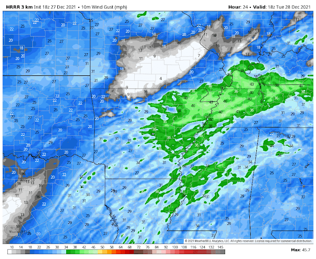 |
| HRRR model wind gusts for Tuesday afternoon. They could be quite gusty at times, maybe 30-40 mph according to this model. (WeatherBell) |
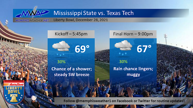
While a few showers will be possible through the day, most of us will likely stay fairly dry under overcast skies. Things are not looking too bad for the Liberty Bowl, but you may want to bring your rain jacket along with your cowbell (Hail State!) just to be safe. The bigger story may be the wind, which could be gusting well up into the 30s at times through Tuesday afternoon. Heading into Tuesday night, a couple showers will linger and winds will calm down ahead of the chance for thunderstorms on Wednesday. Temperatures will remain very mild in the low 60s.
Storms, Round 1: Wednesday
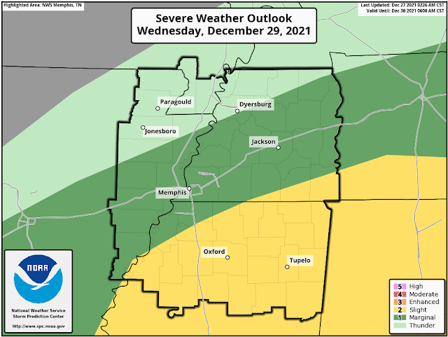
The first round of storms we will see over the upcoming week will occur on Wednesday, likely during the afternoon hours. A few could be on the stronger side with a damaging wind gust or even a tornado or two. The tornado threat is very low in the Memphis area, however, and the best severe weather risk will be to our south over Mississippi. The day will start off fairly dry, but by the early afternoon a round of storms will move through the area. Showers will linger through the rest of the day before we dry out Wednesday night. We’ll stay very warm through the day, with a high near 71.
Thursday and New Year's Eve: a calm couple of days
A front moves through Wednesday night, but doesn’t really drop our temps a whole lot. After a wake up temp in the mid 50s, which is still very warm for the time of year, we’ll have a pleasant rest of the day Thursday with a high near 70. Skies will feature a mix of sun and clouds, and it’s looking like a great day to get outside! We "cool" down to the mid 50s again on Thursday night, with more cloud cover moving in for Friday (New Year’s Eve). The final day of 2021 is once again looking very warm, with a high in the low 70s. A few showers will enter the picture by the evening, and it’s looking warm and potentially wet by midnight when we ring in 2022, with temperatures in the 60s.
Storms, round 2: New Year's Day
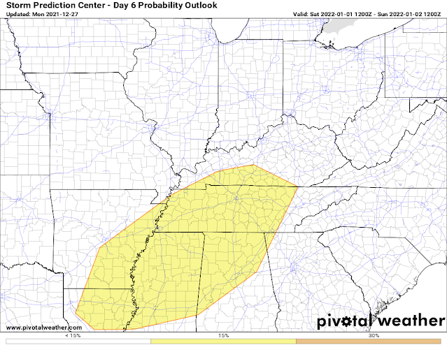
The second round of storms this week comes in on New Year’s Day, especially during the daytime hours. Despite being six days out, the Storm Prediction Center has already highlighted the Mid-South and areas to the south and east for severe weather.
With a powerful cold front and drastic temperature difference moving through the Southeast, this system is looking much stronger than Wednesday’s setup. At this time, I wouldn’t cancel any New Year’s Day plans, but it wouldn’t be a bad idea to have a backup plan in place should things get dicey. At this point, it is too early to nail down specific impacts. However, it is looking like the ingredients could be there to support all modes of severe weather (damaging winds, tornadoes, hail). Timing also hasn’t been nailed down yet. But a scenario exists that may actually work out in our favor: if we get rain in the early morning hours (which models show but don't agree on placement of heavy rain), then the severe risk may be reduced a bit. However, at this time it is looking like the best chance of severe weather will still be in the afternoon as the front approaches. Again, details to come and stay tuned!
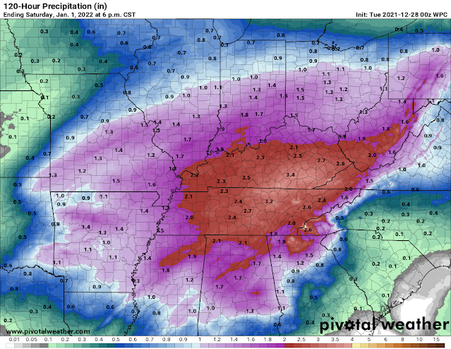 |
| National weather service rainfall forecast through Sunday morning. A widespread 1-3” of rain is likely for the Mid-South, with locally higher or lower amounts possible. (NWS/SPC via Pivotal Weather) |
This will be the last push of very mild air - highs once again will reach the 70s on New Year’s Day. Another threat to watch out for will be brief flooding, as we could see a couple of rounds of rain and storms on New Year’s Day. Rainfall amounts over the next five days will be between 1-3 inches for the Memphis area, with locally higher amounts possible. The good thing is that recent conditions will help to offset a flooding threat from any heavy rainfall we receive. The cold front moves through Saturday night, setting the stage for a frigid Sunday!
Winter arrives next week!
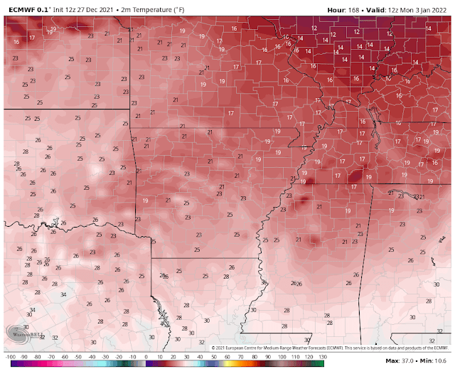
A powerful cold front will push through the area Saturday night, leaving us with plummeting temperatures for Sunday. Morning lows look to be just above or near freezing with highs only in the lower 40s, or about 30 degrees colder than Saturday! With a bit of lingering moisture and very cold temperatures, some snowflakes can’t be ruled out Sunday! For now, we're not looking like anything impactful, so don’t run out for bread and milk just yet! However, both major models (European and American GFS) are hinting at the possibility, so we’ll keep watching as the week goes on. Sunday night, with clear skies, lows will plunge into the mid 20s, with some models even hinting at low 20s and teens by Monday morning! It will be quite the change from the absolute torch that was the month of December.
Personal note
This will be my last blog for MemphisWeather.net, and today is my last day as an intern! It has been such a pleasure writing blogs and covering the past 8 months of wild weather in the Memphis area. I’m very grateful to have had such a great experience, and I will miss writing and tweeting about weather in the Mid-South! I graduated earlier in the month of December from Mississippi State with a Bachelor of Science in Meteorology, and I am currently a meteorologist at WCBI news in Columbus, MS. Follow me on twitter @christianbwx to see my next adventures! With that, meteorologist/intern Christian Bridges signing off :-)
Christian Bridges
MWN Meteorologist Intern
----
Follow MWN on Facebook and Twitter for routine updates and the latest info!
Complete MWN Forecast: MemphisWeather.net on the mobile web or via the MWN mobile app
Download our iPhone or Android apps, featuring StormWatch+ severe weather alerts!
MWN Meteorologist Intern
----
Follow MWN on Facebook and Twitter for routine updates and the latest info!
Complete MWN Forecast: MemphisWeather.net on the mobile web or via the MWN mobile app
Download our iPhone or Android apps, featuring StormWatch+ severe weather alerts!
 |  |
| MWN is a NOAA Weather Ready Nation Ambassador | Meteorologist Erik Proseus is an NWA Digital Seal Holder |

No comments:
Post a Comment