

This year, there's a lot of truth to that meme. I hope Santa has a pair of shorts and a t-shirt at the ready this year! Why is it so stinking warm out?
A few lecture notes from Weather 102
We have to look up - at the upper atmospheric pattern over North America, which is pretty much like a massive roller coaster, and it's persistent! Below we see the average upper air pattern over the continent for the week from Christmas to New Year's Eve. It all starts with a massive high pressure ridge over the North Pacific (red/pink colors are much above average). Like waves in the ocean, right ahead of a crest there is a valley. Look downstream in western Canada and the western U.S. - a n anomalously deep trough (blues to light greens). Because of that trough, there is a large area of high pressure downstream from that, which is centered over the Gulf of Mexico, but has a reach into the southeast U.S. that any social media influencer would appreciate. That pattern has been in place for a few days and, in general, it'll stick around through much of next week!
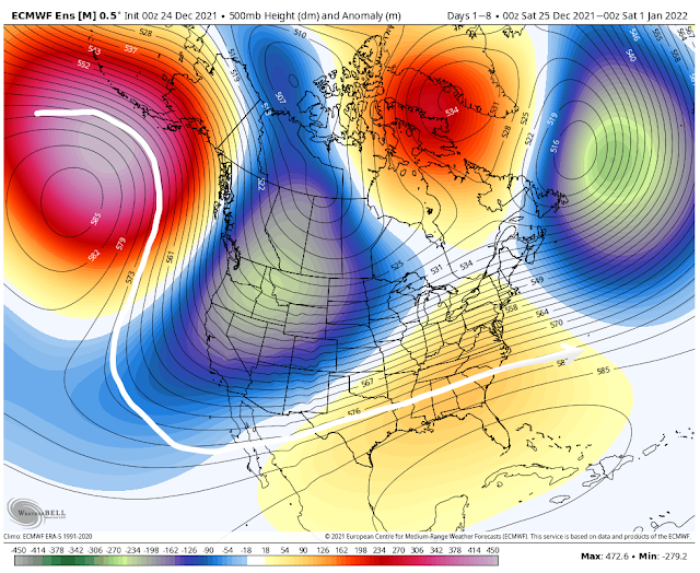 |
| The European model ensemble average pressure pattern at about 18,000' up (500mb for you nerds). The white line helps to visualize the roller coaster pattern of the ridge/trough/ridge pattern. (WeatherBell) |
Where there is high pressure above, there are usually warm temperatures below. Here is the corresponding temperature anomaly map for the same period - Christmas Day through New Year's Eve. Blowtorch. Average temperatures about 22 degrees above normal for the entire week in the Memphis area. (Note the corresponding freezer in southwest Canada where it's 20-30 degrees below normal.)
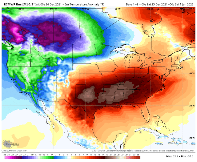 |
| The European model ensemble average temperature departure from normal for December 25-31. (WeatherBell) |
That's cool - but break it down for me, Erik
So what does this mean practically for Christmas weekend into next week? In a nutshell, too warm for the last week of 2021!
- Highs in the 70s and lows in the upper 50s to 60s today through Wednesday
- Daily high temperature records are in jeopardy Christmas Day (76), as well as Tuesday (74) and Wednesday (72).
- Daily maximum low temperature records also in jeopardy on several days
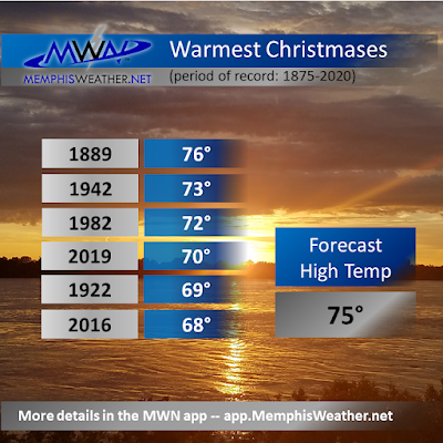
- An average high temperature of 73 degrees from today through Wednesday would be the warmest such stretch since 1889!
I also looked back to the last time we had 70 degree temperatures on Christmas - which was just 2 years ago. It was very warm for a stretch of days that week as well. The average high during that stretch was 68.5 degrees. Again, we're in line for an average high of 73. In addition, mornings that week were in the 40s to mid 50s. Other than Sunday morning, we probably won't see anything below 60 until Thursday. That means dewpoints are higher (muggier), keeping those overnight lows from falling. Here's a look at the warmest Christmas Days on record:
So let's break it down day by day...
Christmas Eve and Christmas Day
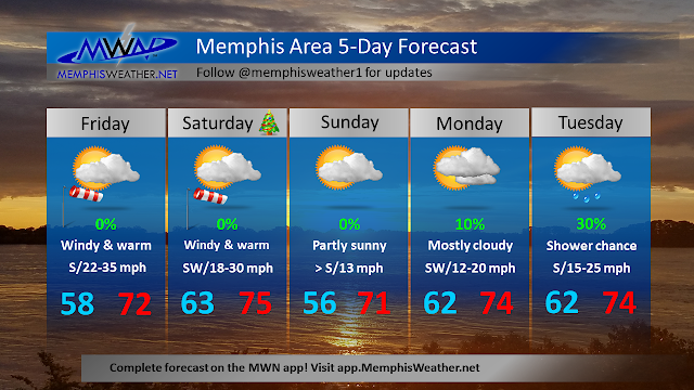
Morning clouds today give way to afternoon sunshine. Very gusty wind to 35-40 mph will help those temperatures reach the low 70s. Not a record, but very warm. It stays mild on strong southerly flow overnight, so Santa needs to start his descent into Memphis from the south for optimal fuel efficiency! It'll be in the low 60s when you wake up to open presents Christmas morning. That's about 12 degrees warmer than the typical high temp! Partly sunny for your Christmas Day with highs in the mid 70s and a continued gusty south wind. Great day for outdoor gatherings if you can hang on to your Chinet plates and wrapping paper.

Sunday into Monday
A cold front will try to sneak south to around the I-40 corridor Sunday night. That will give us a reprieve from the wind and slightly cooler temperatures Sunday morning, but still no rain. Look for lows in the mid 50s. However, like the 4th wave of covid, high pressure to our south says "not so fast" and shoves the front back to the north Sunday afternoon, bringing back south wind and highs again eclipsing 70.
By Monday, the ridge has regained its default position and, despite some cloud cover, another warm and breezy day with lows in the low 60s and highs in the mid 70s. Monday's record of 77 is likely safe.
Tuesday/Wednesday
With the upper ridge well established again, warmth remains. Tuesday could see a few showers and some gusty wind, but highs reach the mid 70s. The morning max low temperature record is 61 and the record high is 74. Both are quaking in their boots (or maybe flip flops).
Goodbye 2021, hello 2022!
Lots of uncertainty in the model data this far out, but if all goes to plan, Thursday we're on the north side of a cold front - a reprieve from the "heat!" A few lingering showers are possible but temperatures look to start around 50 (better, but still the average HIGH for the day) with lows in the low 60s. New Year's Eve looks similar, though the front could start to move back into the area, so all bets really are off on precipitation at this point. Relative warmth looks to continue with highs in the 60s.
Most model ensembles are suggesting another, stronger, front arrives for New Year's Day. This would knock those temperatures down once again, maybe to "slightly above normal" heading into the start of the New Year. Given this is still a bit over a week out, the forecast is probably about as good as last year's January resolutions... stay tuned.
Erik Proseus
MWN Meteorologist----
Follow MWN on Facebook and Twitter for routine updates and the latest info!
Complete MWN Forecast: MemphisWeather.net on the mobile web or via the MWN mobile app
Download our iPhone or Android apps, featuring StormWatch+ severe weather alerts!
 | |
| MWN is a NOAA Weather Ready Nation Ambassador | Meteorologist Erik Proseus is an NWA Digital Seal Holder |
No comments:
Post a Comment