Showing posts with label Christmas. Show all posts

Thursday, December 21, 2023

Not a White Christmas, but a Wet Christmas

As fall officially turns to winter, temperatures are (of course!) warming as we head into a long Christmas weekend. I think we'll take that if the other option is what we had last year - frozen pipes and rolling blackouts! The trade-off is going to be rainy conditions off and on through the weekend. Let's talk about it.

Temperature in Bartlett just before 6am on December 23, 2022 (-0.3°)

As high pressure that brought us cold weather earlier this week slides to our east, wind has shifted to the south, resulting in warmer air over the Mid-South. Low pressure will develop to the west and moisture will increase from the Gulf of Mexico. That will mean less itchy, dry skin as dewpoints have risen from the teens a couple of days ago into the 30s by Friday, and eventually the 40s to 50s later this weekend. 


With the increase in moisture, small rain chances in the form of hit-and-miss brief showers will pop up late Friday and into the weekend. Outdoor plans through much of the weekend, until Sunday evening, should not be overly impacted, and the mild temperatures will make for pleasant conditions for outdoor activities outside of breezy south wind. Just keep in mind that a shower could pop up about anytime 

A loop of the surface weather maps from Friday morning through Tuesday morning, showing 

The main event from the next system will occur on Sunday evening though Monday morning - Christmas Eve into Christmas Day. Heavy rain is likely at times overnight Sunday night and a few rumbles of thunder are even possible. (It may not be reindeer hooves on the roof you hear that night!) Severe thunderstorms are not expected as the primary low pressure center passes well to our north and instability will be limited. Some showers appear to linger into Christmas Day, but could be departing by the afternoon hours. Still too early to know... stay tuned to the MWN Forecast for updates throughout the next few days. The rest of the intra-holiday week looks to be dry and cooler again.

And for those asking about winter weather in early January, it's ENTIRELY too early to even discuss...


Erik Proseus
MWN Meteorologist

----
Follow MWN on Facebook and Twitter for routine updates and the latest info!
Complete MWN Forecast: MemphisWeather.net on the mobile web or via the MWN mobile app
Download our iPhone or Android apps, featuring StormWatch+ severe weather alerts!
MWN is a NOAA Weather Ready Nation Ambassador Meteorologist Erik Proseus is an NWA Digital Seal Holder

Friday, December 24, 2021

Christmas and year-end forecast - unusually warm


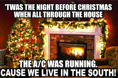
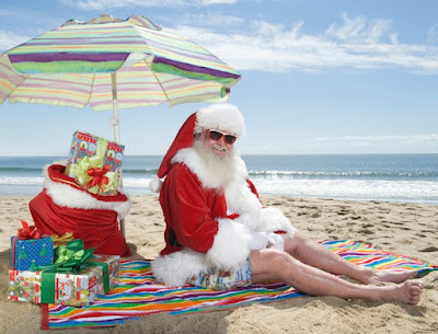
This year, there's a lot of truth to that meme. I hope Santa has a pair of shorts and a t-shirt at the ready this year! Why is it so stinking warm out? 

A few lecture notes from Weather 102 

We have to look up - at the upper atmospheric pattern over North America, which is pretty much like a massive roller coaster, and it's persistent! Below we see the average upper air pattern over the continent for the week from Christmas to New Year's Eve. It all starts with a massive high pressure ridge over the North Pacific (red/pink colors are much above average). Like waves in the ocean, right ahead of a crest there is a valley. Look downstream in western Canada and the western U.S. - a n anomalously deep trough (blues to light greens). Because of that trough, there is a large area of high pressure downstream from that, which is centered over the Gulf of Mexico, but has a reach into the southeast U.S. that any social media influencer would appreciate. That pattern has been in place for a few days and, in general, it'll stick around through much of next week!
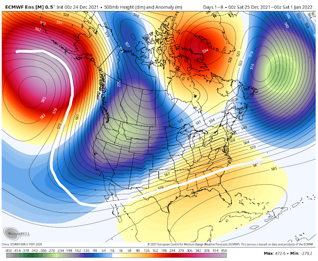
The European model ensemble average pressure pattern at about 18,000' up (500mb for you nerds). The white line helps to visualize the roller coaster pattern of the ridge/trough/ridge pattern. (WeatherBell)

Where there is high pressure above, there are usually warm temperatures below. Here is the corresponding temperature anomaly map for the same period - Christmas Day through New Year's Eve. Blowtorch. Average temperatures about 22 degrees above normal for the entire week in the Memphis area. (Note the corresponding freezer in southwest Canada where it's 20-30 degrees below normal.)
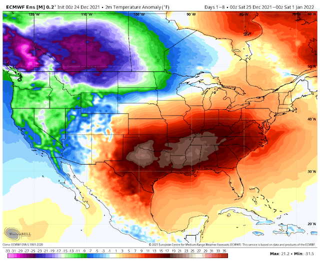
The European model ensemble average temperature departure from normal for December 25-31. (WeatherBell)

That's cool - but break it down for me, Erik

So what does this mean practically for Christmas weekend into next week? In a nutshell, too warm for the last week of 2021!
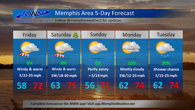
  • Highs in the 70s and lows in the upper 50s to 60s today through Wednesday
  • Daily high temperature records are in jeopardy Christmas Day (76), as well as Tuesday (74) and Wednesday (72).
  • Daily maximum low temperature records also in jeopardy on several days
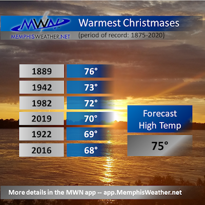
  • An average high temperature of 73 degrees from today through Wednesday would be the warmest such stretch since 1889!
I also looked back to the last time we had 70 degree temperatures on Christmas - which was just 2 years ago. It was very warm for a stretch of days that week as well. The average high during that stretch was 68.5 degrees. Again, we're in line for an average high of 73. In addition, mornings that week were in the 40s to mid 50s. Other than Sunday morning, we probably won't see anything below 60 until Thursday. That means dewpoints are higher (muggier), keeping those overnight lows from falling. Here's a look at the warmest Christmas Days on record:


So let's break it down day by day...

Christmas Eve and Christmas Day

Morning clouds today give way to afternoon sunshine. Very gusty wind to 35-40 mph will help those temperatures reach the low 70s. Not a record, but very warm. It stays mild on strong southerly flow overnight, so Santa needs to start his descent into Memphis from the south for optimal fuel efficiency! It'll be in the low 60s when you wake up to open presents Christmas morning. That's about 12 degrees warmer than the typical high temp! Partly sunny for your Christmas Day with highs in the mid 70s and a continued gusty south wind. Great day for outdoor gatherings if you can hang on to your Chinet plates and wrapping paper.


Sunday into Monday

A cold front will try to sneak south to around the I-40 corridor Sunday night. That will give us a reprieve from the wind and slightly cooler temperatures Sunday morning, but still no rain. Look for lows in the mid 50s. However, like the 4th wave of covid, high pressure to our south says "not so fast" and shoves the front back to the north Sunday afternoon, bringing back south wind and highs again eclipsing 70.

By Monday, the ridge has regained its default position and, despite some cloud cover, another warm and breezy day with lows in the low 60s and highs in the mid 70s. Monday's record of 77 is likely safe.

Tuesday/Wednesday

With the upper ridge well established again, warmth remains. Tuesday could see a few showers and some gusty wind, but highs reach the mid 70s. The morning max low temperature record is 61 and the record high is 74. Both are quaking in their boots (or maybe flip flops). 


As we head into Wednesday, things start to change a bit. Another cold front approaches and this time it appears it could bring some moisture. It'll still be quite warm as the upper ridge still has influence. We're expecting 70 degrees or higher again, but that's thanks mainly to lows in the 60s, so not much warming needed to be near the record again. If the ridge stays stronger, it could delay the front a bit. For now, Wednesday has a 60% chance of showers and a few thunderstorms. Not looking like severe weather so we're good there.

Goodbye 2021, hello 2022!

Lots of uncertainty in the model data this far out, but if all goes to plan, Thursday we're on the north side of a cold front - a reprieve from the "heat!" A few lingering showers are possible but temperatures look to start around 50 (better, but still the average HIGH for the day) with lows in the low 60s. New Year's Eve looks similar, though the front could start to move back into the area, so all bets really are off on precipitation at this point. Relative warmth looks to continue with highs in the 60s. 

Most model ensembles are suggesting another, stronger, front arrives for New Year's Day. This would knock those temperatures down once again, maybe to "slightly above normal" heading into the start of the New Year. Given this is still a bit over a week out, the forecast is probably about as good as last year's January resolutions... stay tuned.

Erik Proseus
MWN Meteorologist

----
Follow MWN on Facebook and Twitter for routine updates and the latest info!
Complete MWN Forecast: MemphisWeather.net on the mobile web or via the MWN mobile app
Download our iPhone or Android apps, featuring StormWatch+ severe weather alerts!
MWN is a NOAA Weather Ready Nation Ambassador Meteorologist Erik Proseus is an NWA Digital Seal Holder

Thursday, December 23, 2021

Christmas Day weather history for Memphis


Undoubtedly one of the most common questions meteorologists get during the holiday season: “Any chance of a White Christmas this year?” That is no less true here in the Mid-South where a significant snowfall at any point in the winter season can be a unique (and disruptive!) event. Fortunately, thanks to a lengthy modern weather record available for Memphis that dates back to 1875, we have a pretty good idea just how likely a White Christmas is, at least statistically speaking. As you'll see below, and as you were already expecting, the odds are not in snow lovers’ favor!

Before jumping ahead to our chances of a White Christmas, here are some temperature statistics for Christmas Day in Memphis, thanks to data compiled by NWS Memphis and the National Climatic Data Center. The coldest Christmas Day in 146 years of records was in 1983 as a major Arctic air outbreak was gripping much of the nation. The high in Memphis that day was a mere 16 degrees after a bone-chilling morning low of 0! No snow that day, though it was plenty cold enough to support it!

High/low temperature map Christmas morning 1983. Brutal cold dominated the nation along/east of the Rockies except south Florida.

On the flip-side, the warmest Christmas Day in the records was in 1889 where the temperature reached a balmy 76 degrees after a mild low of just 63, a month that ended up by far the warmest December in Memphis history. When you average it out over 140+ years of records, a seasonable Christmas Day isn't too bad - with a high temperature of 48 degrees and a low near 33 degrees and skies that average partly cloudy to partly sunny at worst. One particular note of late though, is that 3 of the last 6 Christmas Days (including 2021) have had high temperatures of 68 or warmer.

In terms of any type of precipitation, measurable amounts (0.01” or more) have fallen on Christmas Day 38 times. The vast majority of those years featured just liquid rainfall in mainly light amounts, but one major soaker occurred in 1987 when 4.24” of rainfall was reported at Memphis, following an equally soggy Christmas Eve. Some Mid-South residents spent that Christmas dealing with flooding, the hardest hit of those in West Memphis, AR where cleanup was still underway after a destructive F3 tornado just 11 days earlier on December 14. There have been nine times that more than an inch of rain has fallen on Christmas Day, most recently in 2015 (1.61"). Sleet or freezing rain has been reported on Christmas Day a handful of those times, but just trace or light amounts.

Now the statistic you most want to know. Just how likely (or unlikely!) is a White Christmas in Memphis? The answer definitely lies on the “unlikely” side of the equation; in fact it’s more appropriate to label a White Christmas in Memphis as exceptionally rare. Only once in over 140 years of records has measurable snowfall occurred. That was in 1913 when 3.5” of the white stuff made for the sole exception to the rule we still consider today. However, there have been several other years where snowflakes have been seen in the Memphis skies on Christmas Day but with no accumulation. The most recent was in 2012, a year where Memphis just barely missed an all-out blizzard that hit parts of Arkansas on Christmas Night, with around an inch of snow falling the morning after Christmas in Memphis. In fact, during the four-year span from 2009-2012, snow flurries fell three times on Christmas Day!

Listing of all recorded snowfalls on Christmas Day at Memphis International Airport

Officially, the National Climatic Data Center considers any city to have a “White Christmas” if at least one inch of snowfall is on the ground on Christmas morning, no matter when that snowfall occurred. Using this definition, Memphis does have a few additional years it can add to that list. Those include 1962, 1963, 1998, and 2004, in addition to the 1913 snowfall that occurred on Christmas Day. 2004 is likely the most remembered as the city had around 2” of a sleet and snow mixture covering the ground following a winter storm on December 22. Long-timers of the Memphis area may even better remember the historic Memphis snow of December 22, 1963. 10” of that 14.3” snowfall total still lay on the ground that Christmas morning!
Official "White Christmases" in Memphis, which had at least 1" of snow on the ground.


When considering the NCDC criteria, the odds of a White Christmas in Memphis - with at least 1" of snowfall on the ground - end up right at 3%. Slightly better than the 0.8% odds if you only consider measurable snowfall on Christmas Day itself! Either way, clearly the odds don't fall on your side if you're looking for a White Christmas and want to spend the holiday in Memphis. Perhaps one Christmas soon we'll be able to make a new exception to the rule! Until then, average expectations for any given year would indicate a cool, but not cold, Christmas Day and at best modest chances of precipitation, which almost always falls in liquid form.

Top Image is "Graceland Christmas" by Thomas Kinkade, borrowed from artofthesouth.com.

Blog originally authored by MWN Intern Kevin Terry
Updated by MWN Meteorologist Erik Proseus

----
Follow MWN on Facebook and Twitter for routine updates and the latest info!
Complete MWN Forecast: MemphisWeather.net on the mobile web or via the MWN mobile app
Download our iPhone or Android apps, featuring StormWatch+ severe weather alerts!
MWN is a NOAA Weather Ready Nation Ambassador Meteorologist Erik Proseus is an NWA Digital Seal Holder

Monday, December 21, 2020

Winter officially arrives today, but cold winter air waits until Christmas. How about winter precip?

Quick outlook

Pleasant weather for the first half of the week, rain chances Wednesday, then clear and cold for Christmas.

First half of the week

As winter officially arrives (Monday morning at 4:02am), Monday thru Wednesday will be nice with a return of southerly winds which will bring highs near 60.  Skies will be clear for Monday and most of Tuesday, with increasing clouds Tuesday night.  By Wednesday morning, a cold front will be located from Minnesota and south into the Southern Plains, with rain chances increasing as the front pushes east into more humid conditions across the lower Mississippi Valley.

Wednesday morning surface map

Wednesday cold front

This front will push into the Mid-South Wednesday around sunset with rain chances and windy conditions arriving Wednesday, particularly in the afternoon and evening.  Behind the front, much colder temperatures will quickly push in on a cold northwest wind.  There also will be the potential for some winter weather in far northern Tennessee, but any winter precipitation would be light and not likely to affect the metro. Expect rainfall to diminish by midnight Wednesday night before the coldest air arrives. 


Christmas Outlook

As documented on this blog previously, a White Christmas is extremely rare in Memphis. And this year, despite the chill, will not buck the "sNOw" trend. Christmas Eve (Thursday) and Christmas Day (Friday) will be much colder than the temperatures we will have had in the first part of the week, with highs near 40 and lows near freezing Thursday morning and in the low 20's Christmas morning.  It will be clear, with no precipitation in the forecast.  So Santa will have clear skies and chilly weather as he makes his trip thru the Mid-South!


Weekend outlook

Thankfully, the weekend will be a bit warmer. Saturday will see highs pushing 50 degrees under sunny skies after sub-freezing morning lows. Sunday will be a bit warmer (in the 50s) but with rain chances again as the next frontal system arrives.


Richard Hoseney
MWN Meteorologist

----
Follow MWN on Facebook and Twitter for routine updates and the latest info!
Complete MWN Forecast: MemphisWeather.net on the mobile web or via the MWN mobile app
Download our iPhone or Android apps, featuring StormWatch+ severe weather alerts!
MWN is a NOAA Weather Ready Nation Ambassador Meteorologist Erik Proseus is an NWA Digital Seal Holder

Monday, December 23, 2019

A warm Christmas week in Memphis, plus a look at your Cotton Bowl forecast!

We're coming around to Christmas week which means lots of parties, food and family. The last week wasn't too "active" but we did have rain and storms December 16th and some rain yesterday. For most of the past week temperatures sat around or above average with some cheering and others jeering.

Knowing it's Christmas week, I know many of you want to know whats going to happen this week. Good news is that from now until later this week we should see above average temperatures and little rain chance. That will change heading into the weekend but even then rain amounts aren't expected to be too much.

Image result for christmas

Christmas Eve, Christmas Day and Boxing Day (day after Christmas)

Tomorrow on Christmas Eve you can expect mostly sunny skies, highs in the mid 60s and no real chance of rain. Tomorrow night you can expect temperatures to only drop to the upper 40s. This is due to us expecting some high atmospheric clouds to move in called cirrus clouds. High clouds have been shown to keep some heat from radiating into space, therefore not allowing temperatures to get as low.

On Christmas Day we are again expecting some high atmospheric clouds with no rain chance and highs in the mid 60s. Wednesday night (Christmas Day night) clouds are expected to move in and keep overnight temperatures up. Overnight lows will only drop to the mid 50s. On Boxing Day it will most likely be partly sunny, with highs in the mid 60s and a very small chance of sprinkles. Overnight lows will only get down to the mid 50s due to cloud cover again capping the heat near the Earth's surface. 

Image result for christmas paradise
This is a bit of an exaggeration but temperatures will be unseasonably warm for this time of year around Christmas.


Friday, Saturday and Sunday

Friday will again be much of the same story as Thursday with partly sunny conditions, highs in the mid 60s and a slight chance of rain/showers. Friday night lows are only going to drop to the mid 50s due to cloud cover staying during those hours. Saturday is much of the same story with mostly cloudy conditions, a chance of rain/showers and highs in the mid 60s. Saturday night lows are only going to drop to around 50 with cloud cover overhead and a chance of rain. Sunday you can expect scattered showers and possible thunderstorms, with a high around 60. 

Day 5 image not available
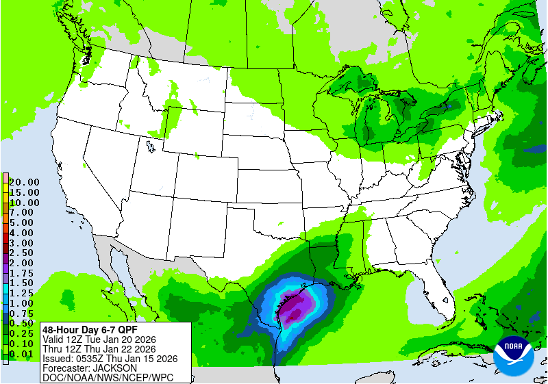
The Quantitative Precipitation forecast (QPF) for Saturday evening through Monday shows that rain totals will probably be around an inch. (NOAA/WPC)

Christmas Weather History

Snow and Memphis don't mix. Some of you may have seen the Christmas Day Weather History Blog posted December 21st. The modern record data for Memphis began in 1875 and only 11 times has a trace amount of snow or more fallen on Christmas Day. Officially, the National Climatic Data Center considers a city to have a “White Christmas” if at least one inch of snowfall is on the ground on Christmas morning, no matter when that snowfall occurred. A "White Christmas" has only occurred eight times since 1875. Last, our historical probability of a White Christmas in Memphis is a whopping 3%! As you can see we don't get very lucky when it comes to White Christmases in the Memphis area. If you wish to read more about the Christmas Weather history click the link here.

Will we cool down after New Years?

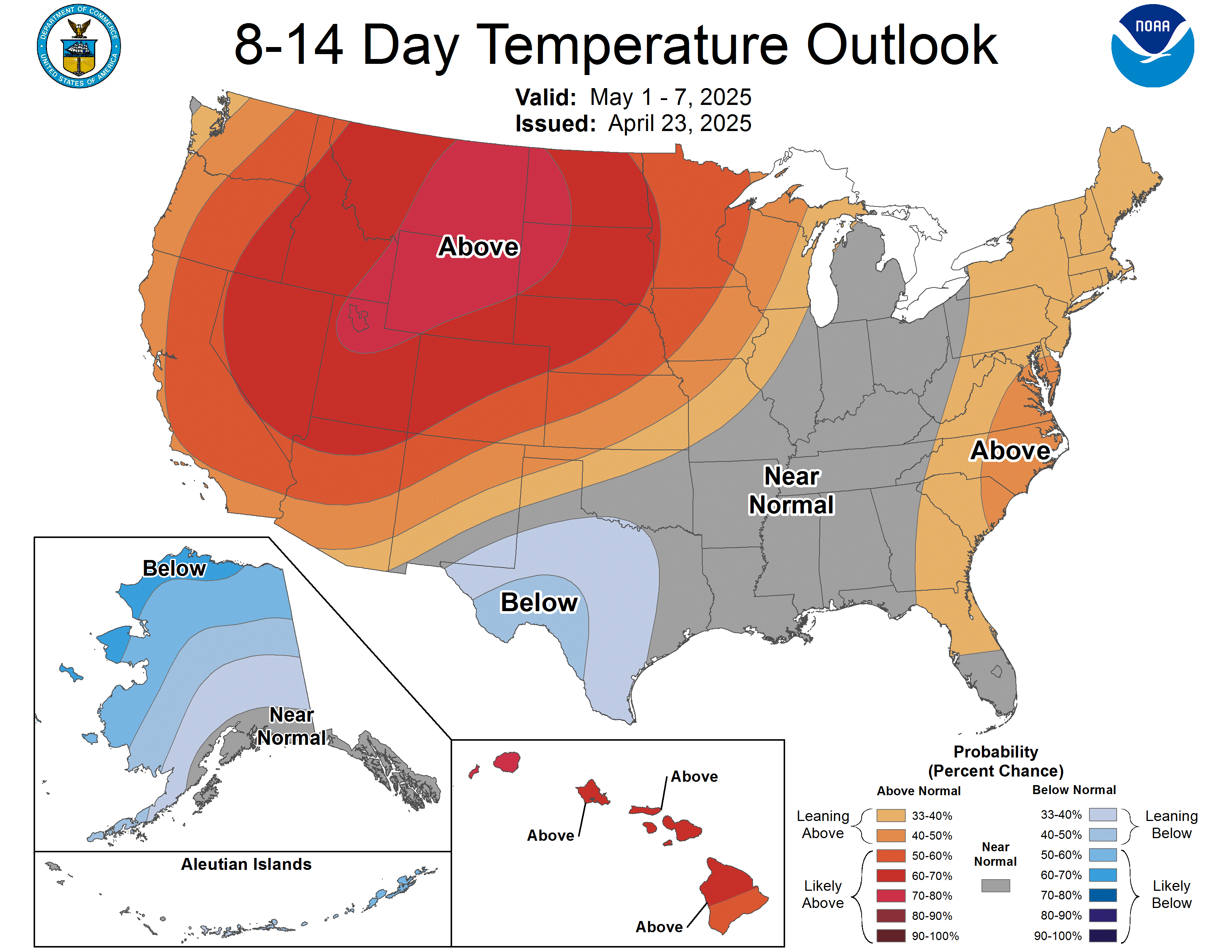
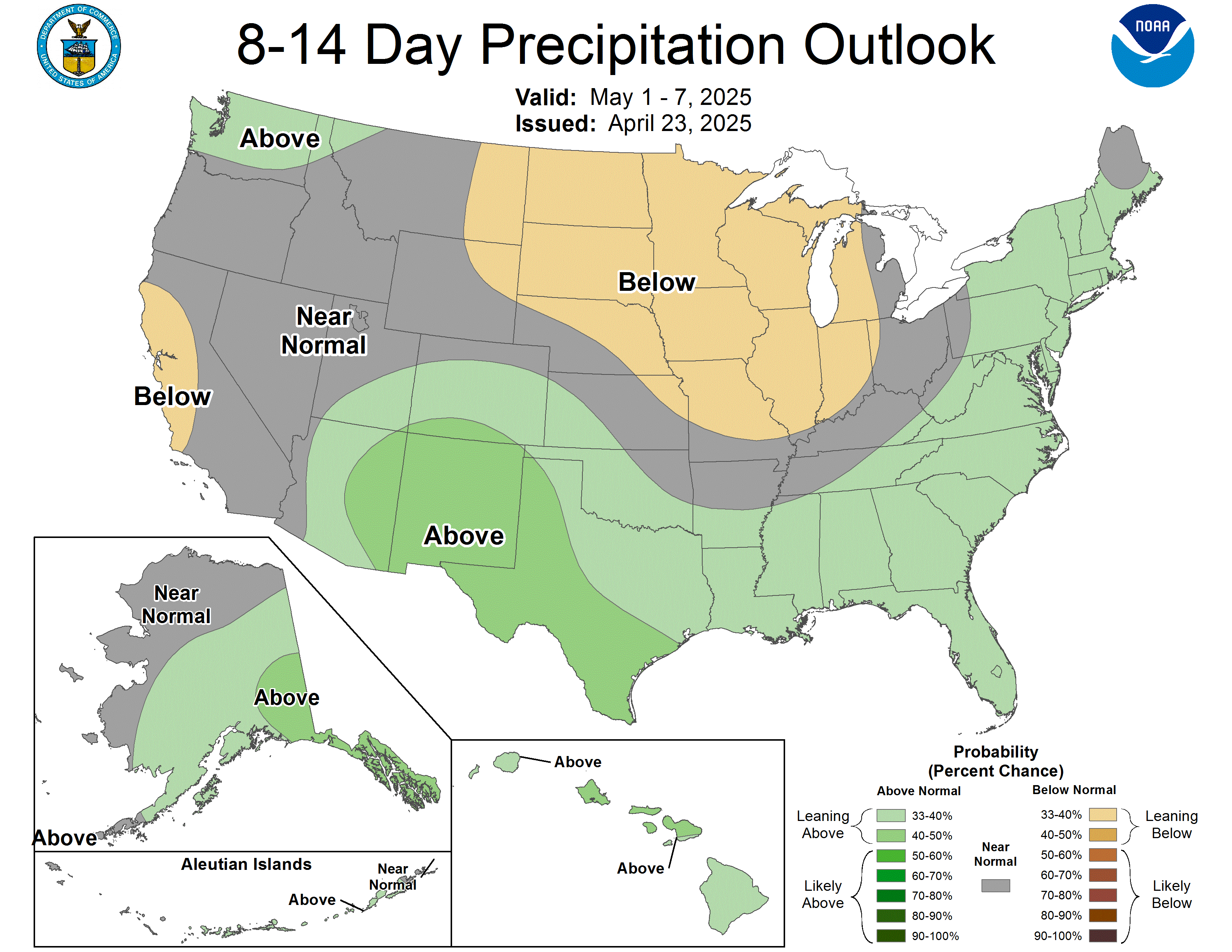
Some will moan and groan over this while others will cheer it on, but the Climate Prediction Center (CPC) is predicting above average temperatures and slightly below average precipitation for the week of December 31st to January 6th. We still could see a cool down the weekend after Christmas if the low pressure system bringing a passing cold front comes to fruition for the area. 

Latest 8 to 14 Day Temperature Outlook
CPC temperature outlook for December 31st to January 6th.
Latest 8 to 14 Day Precipitation Outlook
CPC precipitation outlook for December 31st to January 6th.

Cotton Bowl Forecast

As you likely know, the Memphis Tigers football team is chasing down one more win this weekend, this time in a New Year's 6 bowl game - the Cotton Bowl in Dallas, TX! Some of you might be headed that way after Christmas, so here's what to expect.


If you are driving to Dallas on Thursday, expect fall-like conditions with partly sunny skies and dry weather. Temperatures will mainly be in the 60s with a high Thursday afternoon in the Big D near 70 degrees! Friday will bring a chance of showers as the system approaching Memphis this weekend from the west moves closer to Dallas. Rain chances are in the 30-50% range Friday with warm temperatures - morning lows in the lower 50s and a high in the upper 60s.

For gameday, the good news is the AT&T Stadium has a dome! I expect dry conditions and lower 70s inside, but wet conditions out! There's a high likelihood of rain and perhaps a few Texas thunderstorms. Temperatures will peak in the mid 60s after morning tailgate temps in the mid 50s. I also expect the Tigers to heat up the scoreboard and come out with the biggest win in school history!


For your drive home on Sunday, it should be mainly dry, but models diverge by this point so don't be surprised if you encounter some showers, particularly the closer you get to Memphis. Temperatures will be cooler, but mild. Expect Sunday morning lows in the Dallas to be in the mid 40s, with 50s along most of your drive.

Max Magness
MWN Meteorologist Intern

Erik Proseus
MWN Meteorologist

----
Follow MWN on Facebook and Twitter for routine updates and the latest info!
Complete MWN Forecast: MemphisWeather.net on the mobile web or via the MWN mobile app
Download our iPhone or Android apps, featuring StormWatch+ severe weather alerts!
MWN is a NOAA Weather Ready Nation Ambassador Meteorologist Erik Proseus is an NWA Digital Seal Holder

Tuesday, December 17, 2019

A much calmer week ahead plus a peek at what Christmas Day will hold!

A much calmer week ahead plus a peek at what Christmas Day will hold!

The past week has been anything but calm! We have had thunderstorms to snow flurries with temperatures ranging from 20s to almost 70!


Thankfully we have a much calmer pattern setting up for the coming week. The Southeast will begin a warming trend with mostly above average temperatures starting this weekend through perhaps the remainder of December. The average for this time of year is in the lower 50s meaning here in Memphis we will probably be seeing days with afternoon highs in the lower 60s.


Tuesday Night to Thursday

Earlier this morning we were lucky enough to see a few flurries! This was due to a little leftover moisture mixed with frigid air in the upper levels. This afternoon temperatures struggle to reach 40 but the remaining cloud cover will begin to move out. Tonight temperatures fall quickly into the 20s with overnight lows in the upper 20s. Some low lying areas may experience temperatures in the mid-20s just before sunrise on Wednesday. Throughout the day on Wednesday temperatures warm back up into the 40s by the afternoon. Lots of sunshine on Wednesday and into Thursday make mid-week chilly and bright.

Forecast Morning Temperatures on Wed. 4am (NWS) 
Forecast Afternoon Temperatures on Wed. 4pm (NWS) 

Friday and Saturday

Out the door temperatures for Friday will still be in the 20s but afternoon highs will finally be back into the lower 50s. Clouds return on Friday, starting off the weekend with a mostly cloudy and dreary day. There is an isolated chance at a shower on Friday afternoon, but rain chances increase slightly on Saturday. Overall accumulation will be very low and it is possible that some of us will not see any showers at all. Despite the lingering clouds and rain chance, Saturday’s temperatures will be in the mid 50s with overnight lows in the upper 30s.

Euro Forecast Cloud Cover Valid Friday Morning 7am (WeatherBell)

Sunday and Monday

Sunday and Monday continue the warming trend with afternoon highs in the upper 50s nearing 60 on Monday. Clouds decrease on Sunday leaving the start of the week very sunny. Overnight lows will be around 40 making the mornings chilly but thankfully not frigid! These seem to be the start of our above average trend but sunshine and 60s are hard to beat!

Way too early look at Christmas

It looks like Christmas Eve and Christmas Day are looking pretty nice! It is over a week away so we will have to keep an eye on if things change but for now very nice weather ahead for December the 25th! Above average temperatures will be seen across the southeast giving us a high around 60. Rain (and snow) chances look to be minimal giving Christmas Day a decent dose of sunshine but some high clouds are possible throughout the day ahead of our next system! Despite the increasing clouds lets hope Christmas will be Merry and Bright!


Paige Davide
MWN Meteorologist Intern

----
Follow MWN on Facebook and Twitter for routine updates and the latest info!
Complete MWN Forecast: MemphisWeather.net on the mobile web or via the MWN mobile app
Download our iPhone or Android apps, featuring StormWatch+ severe weather alerts!
MWN is a NOAA Weather Ready Nation Ambassador Meteorologist Erik Proseus is an NWA Digital Seal Holder

Thursday, December 20, 2018

A look ahead to your Christmas forecast

Weekend Before Christmas

The weather looks to cooperate for all your weekend Holiday parties and festivities! A cold front will pass through overnight tonight (Thursday night – Friday morning). Friday morning some drizzle will still be possible, but as the front moves out, the moisture will move out as well, allowing skies to gradually clear by late in the day. Drier, colder air will be moving in Friday after the frontal passage, keeping temperatures in the lower 40s and dropping to near freezing at night. All in favor of Friday’s forecast being our Christmas forecast? I wish!

Decent weather is expected Saturday and Sunday with high temperatures in the mid 50s and lows in the mid 40s. There is a chance of some showers late Saturday night into Sunday morning as another cold front pushes through Sunday. The GFS model (shown below) for 6pm Saturday through 6pm Sunday has only 0.02 inches of rain falling and most of it remaining in north MS. Other models have rain occurring further west and north, but the most significant precipitation occurring east of I-40.

GFS model showing most most measurable rainfall remaining in north MS early Sunday, though other models are a little more bullish for the metro. (WxBell)

Christmas Eve (Monday)

Christmas Eve looks to be just an average December day! The high temperature is forecast to be slightly above average (mid 50s) and the low right near average (mid 30s). Some sun is likely to peek out on Christmas Eve, but at least we’ll be waking up to 30 degree temperatures on Christmas morning!


Christmas Day Outlook

Christmas Day is when the forecasting challenge arrives. One reliable model is hinting at scattered showers throughout the day as moisture returns to the area. Changes to this forecast are likely with 5 days still to go before the holiday, but prepare for the possibility.

The big Christmas Day question: Will it be cold enough to “feel” like Christmas? The average is high for Christmas Day in Memphis is 48 and the average low is 33. The forecasted high is in the mid 50s, which puts us above average, but not necessarily warm. It’ll be cool enough to keep on that tacky Christmas sweater and still be comfortable!


Christmas Climatology

The charts below show Christmas Day climatology for the Memphis area. The warmest December 25th on record occurred in 1889 with a high of 76°. The coldest December 25th on record occurred in 1983 when the temperature reached 0° and didn’t climb above 16°. Anyone remember this Christmas Day?

The warmest Christmas Days in Memphis recorded history. 

The coldest Christmases in Memphis history.

Be sure to follow us throughout the upcoming weekend as we fine-tune the forecast for Christmas Day! Hopefully the rain chances disappear, though don't count on a White Christmas this year! You can find the latest forecast on our mobile app or website with links posted below.

Lauren Pounds, Guest Blogger
MWN Social Media Intern

[ Editor's Note: Lauren has been a dedicated social media intern for MWN for 2 years and is about to depart #TeamMWN as she prepares for a busy last semester at Mississippi State and graduation in May. It was only fitting that she have the opportunity to write a blog "in her own words" before moving on, since she has completed her first real forecasting class. My deepest appreciation and thanks to Lauren for the amazing job she has done for me, and all of you, the past two years! We wish her the best this spring, and in the future, as she achieves her dream of becoming a meteorologist! 
--Erik ]

----
Follow MWN on Facebook and Twitter for routine updates and the latest info!
Complete MWN Forecast: MemphisWeather.net on the mobile web or via the MWN mobile app
Download our iPhone or Android apps, featuring StormWatch+ severe weather alerts!
MWN is a NOAA Weather Ready Nation Ambassador Meteorologist Erik Proseus is an NWA Digital Seal Holder