
The Setup
A warm front will move north over us early Friday morning, bringing (even more) warm and humid air into the Mid-South. A slow-moving cold front over the Central Plains will move southeast on Friday, picking up speed and reaching the Mid-South early Saturday. This will lead to the potential for severe thunderstorms late Friday evening into Saturday morning, with the possibility of damaging wind gusts and a few tornadoes.
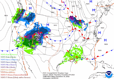 |
| Surface features and precipitation from Thursday night thru Saturday night (NOAA/NWS) |
Thursday's Model Guidance
As of Thursday afternoon, computer models are differing on where and when the storms will develop, with the possibility of either storms developing after 9pm over us, or waiting until around 2am. With either scenario, we should expect the possibility for severe storms late Friday and into early Saturday morning.
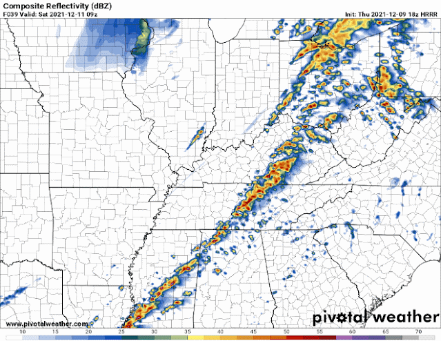 |
| Comparison of the HRRR and NAM3 models valid at 3am Saturday, showing widely different scenarios. (PivotalWeather) |
What's Gonna Happen?
Gusty southwest winds, warming temperatures and increasing humidity are expected on Friday. High temperatures will reach the mid 70s fairly easily, with dewpoints in the high 60s (fairly absurd for this time of year, to be honest). By Friday afternoon and early evening, expect scattered showers and gusty south winds. For Friday evening after about 9pm, scattered strong to severe storms will be possible, but we're not completely convinced these will happen (see next paragraph). Late Friday night into early Saturday morning, expect another potential wave of strong to severe storms moving in from eastern Arkansas ahead of the cold front. The severity of these storms could well depend on how round one in the late evening plays out. By Saturday around daybreak, expect a final quick round of showers along the cold front, followed by gusty northwest winds and much colder temperatures moving in.
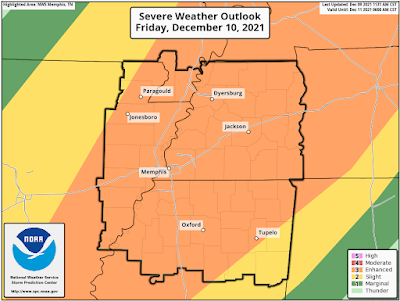 |
| The Storm Prediction Center severe weather outlook for Friday night places Memphis squarely in a level 3 risk out of 5 (Enhanced), indicating scattered severe storms are likely. (SPC) |
Uncertainty
One of the biggest uncertainties, as described above, is the conditional chance for storms Friday evening. If they happen, they would have the biggest severe threat, have a higher potential for tornadoes and likely lessen the severe threat during the early morning hours on Saturday. If they don't occur, the severe threat would be highest after 2am Saturday, with damaging winds and a lower (but still possible) tornado threat. Clouds and scattered showers over us on Friday would lessen the severe threat (which is the most likely scenario), while a bit of sunshine would mean a higher severe threat Friday evening.

To wrap up...
There is a threat for severe weather Friday night into Saturday morning. We will get thunderstorms, with some likely to be severe. Depending on when we see these storms will determine how severe they will be. We will know more on Friday, so please continue to check our latest posts on social media (Twitter & Facebook). But we're not expecting a widespread severe weather outbreak here, just some strong to severe storms during the evening and/or overnight hours Friday night into Saturday.
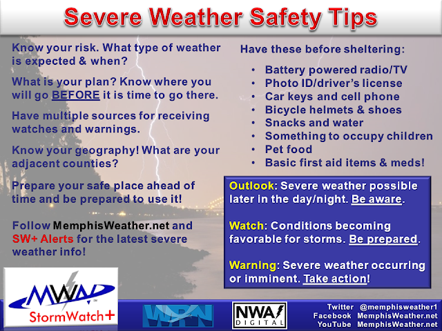
So be prepared, not scared, for severe weather Friday night into early Saturday morning. Below are some tips you can follow leading up to the event.
MWN Meteorologist
----
Follow MWN on Facebook and Twitter for routine updates and the latest info!
Complete MWN Forecast: MemphisWeather.net on the mobile web or via the MWN mobile app
Download our iPhone or Android apps, featuring StormWatch+ severe weather alerts!
----
Follow MWN on Facebook and Twitter for routine updates and the latest info!
Complete MWN Forecast: MemphisWeather.net on the mobile web or via the MWN mobile app
Download our iPhone or Android apps, featuring StormWatch+ severe weather alerts!
 | |
| MWN is a NOAA Weather Ready Nation Ambassador | Meteorologist Erik Proseus is an NWA Digital Seal Holder |
No comments:
Post a Comment