
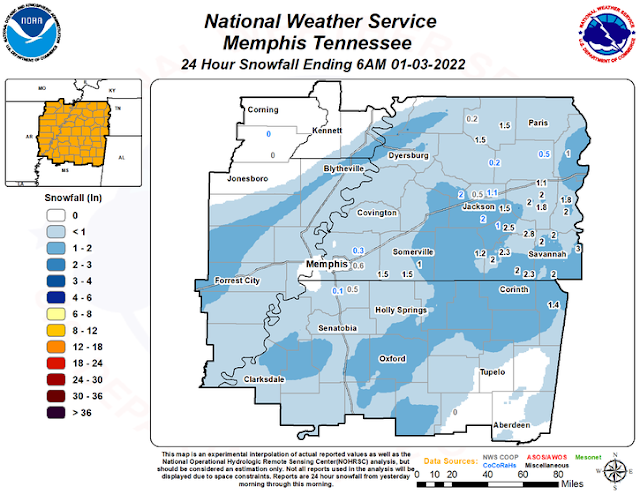
Winter took its sweet time arriving, but once it did... did it ever! An all-time January record high tied on New Year's Day (79) was interrupted by thunderstorms and a piledriver of a cold front that brought a shock to the system on Sunday. Sleet and then snow fell as an upper level low moved through the resultant cold airmass, dropping anywhere from a quarter to nearly 2" of winter precip in the metro, highest totals to the east of Memphis.
Well below average temperatures are lingering over the Mid-South to start the first full week of 2022, but more seasonal conditions arrive late today into Wednesday. However, that will be brief as another cold front arrives late Wednesday. Though the front will be dry, another upper level system in its wake will be noticed on Thursday with another chance of a wintry mix or snow.
General overview for Thursday
Forty-eight hours out, there are still some differences in the model data that have to be worked out in order to get the details right, but the overall scenario should play out something like this:
Light precipitation will move in from the southwest Wednesday night. With temperatures throughout the low levels of the atmosphere still above freezing, anything that falls prior to about 4-6am will be rain and it likely won't be much. However, colder air from the northwest will arrive as the upper level energy approaches and precipitation expands. This should lead to a transition to rain/sleet/snow, then eventually all snow Thursday morning.
A few details that still need to be worked out include the timing of that transition, which will affect not only when it occurs but how much of various precipitation types fall. An earlier arrival of cold air will mean more snow and less ice with snow falling not long after sunrise. A later transition, favored by a couple of models, would mean more rain and potentially sleet, with moisture starting to depart before the coldest air (and snow) arrives.
 |
| Comparison of European model (left) to GFS model (right) from 6pm Wednesday to 6pm Thursday. These models are fairly similar in general, but the details need to be worked out. (WeatherBell) |
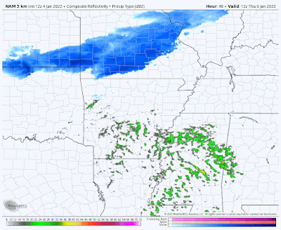 |
| The NAM3 model from 6am to 6pm Thursday is not as promising as other models, with rain going by just to our south and snow to the north. Lower precip amounts would be expected in the metro. Bah humbug! (WeatherBell) |
Wintertime Math
The amount of moisture to actually fall for the event will probably be between 0.10" and 0.20" (though that could change too). Remember that snow generally accumulates at a ratio of around 1" to 0.10" of liquid (or 10:1). Sleet is about a 3:1 ratio. Freezing rain and plain rain is 1:1. So a bit of quick weather math says that if snow starts earlier, and say 0.10" of liquid results in snow, it would be an inch of snow. A later transition, maybe with less than 0.05" of liquid falling during the "snow period" would result in a dusting to half an inch.

My best estimate at this point is we'll get a glaze of freezing rain and sleet, followed by less than an inch of snow, all starting around or just after sunrise and ending by early afternoon. So, I would be preparing for the likelihood of minor accumulations of snow and sleet Thursday morning that could result in travel issues, particularly for the places we typically expect them - bridges, overpasses, etc.
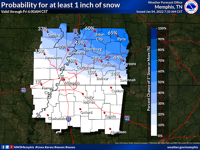
Here are a couple of initial graphics from NWS-Memphis regarding snow potential:

With temperatures falling into the 20s in the afternoon and wind chills in the 20s, I would not expect much in the way of improvement on the ground other than from tires of the vehicles driving over whatever might have fallen. Some initial melting will occur but a quick burst of snow or sleet and travel could become difficult in spots. Friday will continue the bitter cold weather with lows in the upper teens and highs in the 30s. Any snow that falls will likely stick around into the weekend.
We plan to provide additional detail as we get closer, likely on Wednesday. Stay tuned!
MWN Meteorologist
----
Follow MWN on Facebook and Twitter for routine updates and the latest info!
Complete MWN Forecast: MemphisWeather.net on the mobile web or via the MWN mobile app
Download our iPhone or Android apps, featuring StormWatch+ severe weather alerts!
 | |
| MWN is a NOAA Weather Ready Nation Ambassador | Meteorologist Erik Proseus is an NWA Digital Seal Holder |
No comments:
Post a Comment