Showing posts with label video. Show all posts

Sunday, January 1, 2023

Severe Weather Briefing (VIDEO) - Storms expected Monday afternoon into Monday night

MWN meteorologist Erik Proseus reviews the potential for severe weather on January 2-3, 2023, including threats from two waves of storms, timing, and safety and preparation information. Graphics used in the video are shown below. 

Stay with us on Facebook and Twitter for the latest information, as well as routine updates during the storms.


Erik Proseus
MWN Meteorologist

----
Follow MWN on Facebook and Twitter for routine updates and the latest info!
Complete MWN Forecast: MemphisWeather.net on the mobile web or via the MWN mobile app
Download our iPhone or Android apps, featuring StormWatch+ severe weather alerts!
MWN is a NOAA Weather Ready Nation Ambassador Meteorologist Erik Proseus is an NWA Digital Seal Holder

Tuesday, December 20, 2022

"Arctic Blast" - Video Forecast Discussion - December 20, 2022

As the coldest December air in 33 years prepares to infiltrate the Mid-South just ahead of the busy holiday weekend, we review the atmospheric setup, the timing, the impacts, how to best prepare, and how long this cold spell will last! Below are a couple of the graphics used in the video to help summarize the event. 


Erik Proseus
MWN Meteorologist

----
Follow MWN on Facebook and Twitter for routine updates and the latest info!
Complete MWN Forecast: MemphisWeather.net on the mobile web or via the MWN mobile app
Download our iPhone or Android apps, featuring StormWatch+ severe weather alerts!
MWN is a NOAA Weather Ready Nation Ambassador Meteorologist Erik Proseus is an NWA Digital Seal Holder

Saturday, August 20, 2022

Changes ongoing and upcoming at MemphisWeather.net!

A lot has been going on behind the scenes this year for MemphisWeather.net. While most changes take place "under the hood," some will manifest themselves to our followers and friends over the coming few months. We thought it would be a good time to shine the light on a few of them:

Staff addition to Cirrus Weather

For at least a few years, I've been keeping my eyes open for the right person to help expand the MWN offerings, grow the brand, and honestly, take a bit of the load off once in a while, especially during active weather periods. In the fall of 2020, I brought on a friend and local meteorologist in a contracting role to write a few blog posts, cover inclement weather for MWN occasionally, and help maintain the StormWatch+ brand. The "trial period" was highly successful and this past spring, our business relationship was formalized. Meteorologist Richard Hoseney joined me as co-owner of Cirrus Weather Solutions, LLC!

Richard was born and raised in the Mid-South, and has always been a fan of the weather since getting involved with Storm Spotter training from the NWS here in Memphis.  He attended Mississippi State and earned his Bachelor's Degree in Meteorology in 2005, interning back in 2003 at FOX 13 with Jim Jaggers.  He chased some prominent hurricanes too! Richard was in Gulfport during Hurricane Katrina, in Orange (Texas) during Hurricane Rita, and in Pascagoula during Hurricane Ivan.  

After graduating, he met his wife who is originally from eastern Oklahoma.  They moved to Oklahoma where Richard worked at a locally-owned radio group as their staff meteorologist, covering everything from severe weather to ice storms to flooding, and formed a partnership with the county's Emergency Management in assisting the storm spotters during severe weather.  While in Oklahoma, Richard got into aviation, obtaining his private pilot certificate and his own plane. (And now he pilots #MWNDrone1 as well!)  In 2018, Richard and his wife moved back to the Mid-South after accepting a job as a meteorologist at FedEx.  He loves the Mid-South and enjoys forecasting the weather, especially severe weather. Richard has been actively working on several projects to improve the services offered by MWN over the past few months. You'll be seeing more of the fruits of his labor soon! Speaking of which...

MWN Live Streams

One of the projects Richard has taken on that we think you all will benefit greatly from is the addition of severe weather live streams via YouTube. We've been tweaking the software setup and training behind the scenes in order to begin offering you the opportunity to "look over our shoulder" and see detailed views of radar and other tools we use during severe weather. There will also be a live chat where you can ask us questions and get explanations on what you see out your window, or just over the horizon! We might even bring on one of our meteorology student interns at times to help out! 

Our goal is to enhance MWN's content in a way that provides real-time updates for the storms affecting YOU. We'll basically be making our hyperlocal, no-hype coverage more widely available - via your mobile device or even your smart TV! And it will be done with no ads, no fees, and no preempting your favorite shows. We'll let everyone know via our Facebook and Twitter feeds when we start a broadcast, but the best way to find out is to subscribe to our YouTube channel then click the bell for notifications when we go live! Be watching for a debut broadcast soon!

Changes to the Cirrus Weather app offerings

A significant shift has taken place over the past year in our mobile app sector. Most of you are aware that we offer two mobile apps - MemphisWeather.net and StormWatch+. These apps (including Android and iOS versions of each) have been the work of a single app developer since their inception over 10 years ago. Our "app guy" is unbelievably smart. He has shown his dedication to all of you for a decade and receives all of the credit for your ability to get your daily dose of MWN, and also to receive valuable severe weather alerts that ensure your safety and sanity. We are eternally grateful for his tireless and dedicated efforts. 

But maintaining what is effectively four apps was becoming a challenge, so we mutually agreed to move in new directions. Fortunately, after searching for just the right match, we are excited to have secured a new development firm based in our home state of Tennessee, Rise Above Creative! This transition will mean a change in our mobile app offerings though (which, to be honest, was the path we were headed down anyway).

The StormWatch+ app is currently being rebuilt from the ground up in an easier-to-maintain format. Once it is "re-launched" in a couple months, we will be integrating your trusted MWN content into the StormWatch+ app. This will simplify things for us significantly, while still allowing us to provide the most-used content from MWN in app form. In addition, you'll gain access to reliable nationwide weather information that some of you have been asking for in the MWN app, as well as maintaining the super-fast and pinpoint-accurate SW+ Alerts severe weather notifications that many of you already use in either the MWN or StormWatch+ apps. As always, all of this will be available without a single advertisement in the app and with a tight grip on your personal data!


We'll be communicating further as the transition time nears, but for right now, there is nothing you need to do. We look forward to a streamlined experience for our app users and getting all of the information you need in a one-stop shop!

That's the gist of it! We hope these changes and additions are well-received, and we always appreciate your support as well as your inquiries. We would appreciate you taking a minute to hop over to our YouTube page and clicking subscribe (then don't forget to click the bell!), and we'll keep you posted on app updates as they draw near!

----
Follow MWN on Facebook and Twitter for routine updates and the latest info!
Complete MWN Forecast: MemphisWeather.net on the mobile web or via the MWN mobile app
Download our iPhone or Android apps, featuring StormWatch+ severe weather alerts!
MWN is a NOAA Weather Ready Nation Ambassador Meteorologist Erik Proseus is an NWA Digital Seal Holder

Tuesday, February 1, 2022

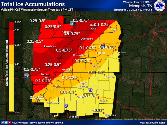
Tuesday evening video update on Thursday's winter storm

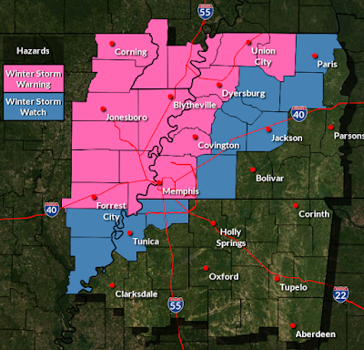
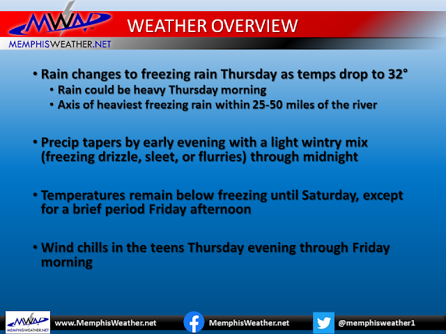
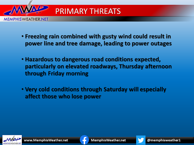
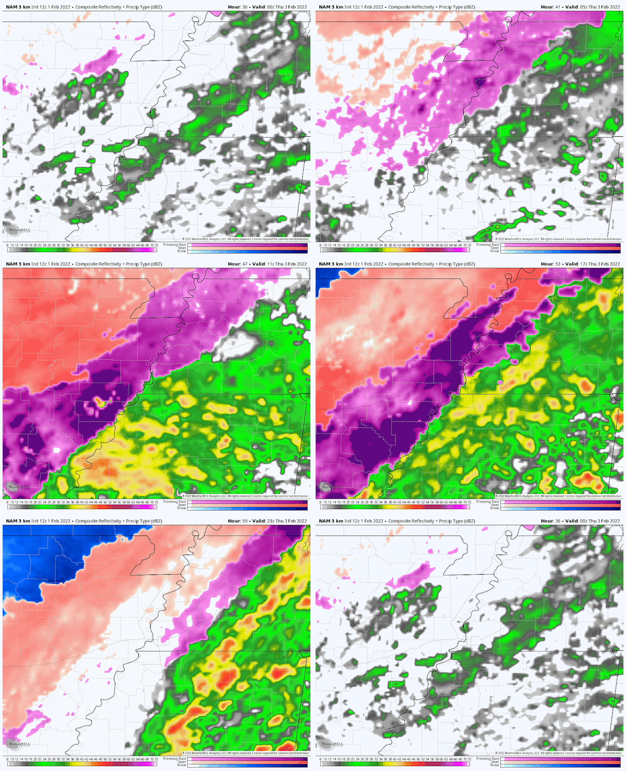
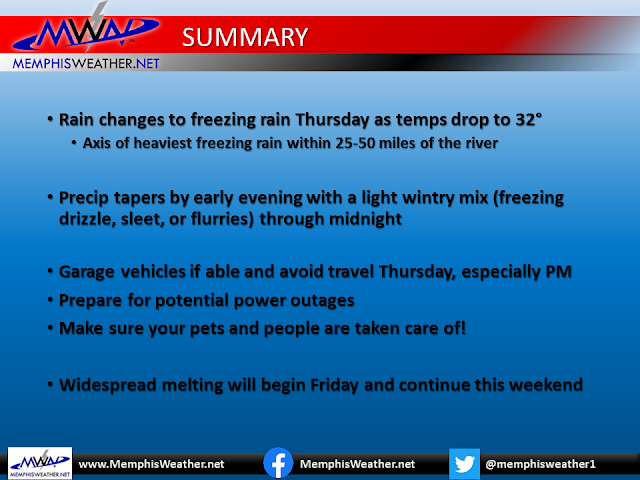
This 13 minute video was recorded at 7pm Tuesday and covers what you need to know ahead of Thursday's winter storm! Images and slides from the video are below. Further updates will be available on our social media channels throughout the next couple days.


Winter Storm Headlines as of 6pm Wednesday


NAM3 model forecast radar from 6pm Wednesday to 6pm Thursday


Erik Proseus
MWN Meteorologist

----
Follow MWN on Facebook and Twitter for routine updates and the latest info!
Complete MWN Forecast: MemphisWeather.net on the mobile web or via the MWN mobile app
Download our iPhone or Android apps, featuring StormWatch+ severe weather alerts!
MWN is a NOAA Weather Ready Nation Ambassador Meteorologist Erik Proseus is an NWA Digital Seal Holder

Sunday, February 14, 2021

Valentine's Mid-Day Update on incoming #memsnow storm

I did a Facebook Live detailing what to expect over the next 24-36 hours, and peeked at the rest of the week. Here's the 15 minutes video:


Here is the latest forecast snowfall totals from NWS-Memphis:


And a few of the graphics from the presentation below. Please stay WARM and stay SAFE!


Erik Proseus
MWN Meteorologist

----
Follow MWN on Facebook and Twitter for routine updates and the latest info!
Complete MWN Forecast: MemphisWeather.net on the mobile web or via the MWN mobile app
Download our iPhone or Android apps, featuring StormWatch+ severe weather alerts!
MWN is a NOAA Weather Ready Nation Ambassador Meteorologist Erik Proseus is an NWA Digital Seal Holder

Monday, October 3, 2016

Hurricane Matthew and Mid-South Weather Update - October 3, 2016

Please see below for a Facebook Live video update of the status of Category 4 (Major) Hurricane Matthew, which looks like it could threaten the U.S. later this week, as well as a Mid-South weather update, featuring warmer temperatures this week and a cool-down in time for the weekend!

Click here for a direct link to the video on Facebook.


And below is a cool plot from a buoy that Matthew went directly over in the southern Caribbean. Stunning!


Erik Proseus
MWN Meteorologist

----
Follow MWN on Facebook, Twitter, and Google+
Visit MemphisWeather.net on the web or m.memphisweather.net on your mobile phone.
Download our iPhone or Android apps, featuring StormWatch+ severe weather alerts!
MWN is a NOAA Weather Ready Nation Ambassador Meteorologist Erik Proseus is an NWA Digital Seal Holder

Saturday, January 30, 2016

MWN Video Blog: Details on weekend warmth, then Tuesday storms

A very warm weekend is in progress, but the crystal ball has a good chance of strong to severe storms in it for Tuesday. We break down the weather for this weekend and an early look at what we might expect on Tuesday afternoon in today's video blog shown below.


We are monitoring the potential for severe weather on Tuesday, mainly in the afternoon Currently, there is a 30% risk of severe weather within 25 miles of Memphis. Graphic courtesy SPC.
Monitor our social channels listed below, this blog, and our website and mobile apps for the latest updates and dust off the severe weather action plan you had ready back on December 23rd when severe weather was expected.

Erik Proseus
MWN Meteorologist

----
Follow MWN on Facebook, Twitter, and Google+
Visit MemphisWeather.net on the web or m.memphisweather.net on your mobile phone.
Download our iPhone or Android apps, featuring StormWatch+ severe weather alerts!

Tuesday, December 22, 2015

Tuesday evening update on severe weather expected Wednesday

Here's the latest on tomorrow's severe weather potential as of 7:30pm Tuesday night. Take 11 minutes to watch and get all the information you need to prepare, then another 10-15 minutes to take those preparation steps tonight. Severe weather is LIKELY tomorrow. 


As mentioned in the video, be sure to check out StormWatch+ in the MemphisWeather.net mobile apps for iOS and Android. For $7.99 (plus $0.99 for the base app), you get a portable, customizable, PRECISION severe weather alert notification system. Think of it like a 2015 version of a weather radio that only alerts you if you need to be alerted! Link for more information and to download is below.

We'll have more updates starting early Wednesday on Twitter and Facebook.

Erik Proseus
MWN Meteorologist

----
Follow MWN on Facebook, Twitter, and Google+
Visit MemphisWeather.net on the web or m.memphisweather.net on your mobile phone.
Download our iPhone or Android apps, featuring StormWatch+ severe weather alerts!

Monday, December 21, 2015

MWN Video Discussion - Severe weather threat Wed and Christmas weather

MemphisWeather.net meteorologist Erik Proseus takes a look at your Christmas week forecast, including a travel outlook for those leaving the area this week to visit family and friends. An in-depth examination of the meteorology behind our severe weather threat on Wednesday is also discussed for you weather nerds. If you just want to know what to expect this week from a forecast perspective, fast forward to the 21:00 mark!


We advise you to have multiple ways of getting severe weather information on Wednesday, including NOAA Weather Radio, local TV/radio, and a smartphone warning app. We recommend our own app, of course! MemphisWeather.net for iPhone and Android includes an optional push notification warning service called StormWatch+. For $7.99 one-time, you get a fully-customizable mobile weather radio that alerts you only if you are in the path of a storm, not if your county is. Get more information and download the app at the link provided below.

Stay with MWN on Facebook and Twitter for updates as warranted throughout the week. Have a safe and happy Christmas week!

Erik Proseus
MWN Meteorologist

----
Follow MWN on Facebook, Twitter, and Google+
Visit MemphisWeather.net on the web or m.memphisweather.net on your mobile phone.
Download our iPhone or Android apps, featuring StormWatch+ severe weather alerts!

Tuesday, March 3, 2015

Tuesday night update on Wednesday night's winter storm [video blog]

15 minute video blog embedded below with details on the Wednesday night winter storm as we see them as of 7pm Tuesday night.

Details continue to come together, though some model solutions still seem to be a little questionable. Despite that, impacts are expected to be significant Wednesday night and Thursday. The main change from previous updates is a delayed onset of winter precipitation and slightly enhanced precipitation amounts.


And for those that want the bottom line, a few graphics:

Approximate position of the freezing line indicated by black dashes, indicating roughly when precipitation changes from rain to freezing rain, followed a few hours later by sleet, then snow after midnight.


Bitterly cold temperatures will end the week, followed by a steady warming trend. Roads should improve markedly (especially primary roads and interstates) on Friday with March sun and some traffic.

More updates Wednesday and throughout the event... follow us on social media and MemphisWeather.net.

Erik Proseus
MWN Meteorologist

----
Follow MWN on Facebook, Twitter, and Google+
Visit MemphisWeather.net on the web or m.memphisweather.net on your mobile phone.
Download our iPhone or Android apps, featuring StormWatch+ severe weather alerts!

Monday, March 2, 2015

Monday night details on Wednesday's winter storm [video blog]

15 minute video blog embedded below with details as we see them as of 9pm Monday night. TIMING, PRECIPITATION TYPES, AND AMOUNTS SUBJECT TO CHANGE. The general pattern seems to be coming together though.


And for those that want the bottom line, first a graphic from the NWS and then our call on this storm and potential impacts:


More updates Tuesday and throughout the event... follow us on social media and MemphisWeather.net.

Erik Proseus
MWN Meteorologist

----
Follow MWN on Facebook, Twitter, and Google+
Visit MemphisWeather.net on the web or m.memphisweather.net on your mobile phone.
Download our iPhone or Android apps, featuring StormWatch+ severe weather alerts!

Tuesday, December 30, 2014

New Year's Eve forecast and a chance of wintry weather Thursday night [VIDEO]

Wrapping up 2014 with a brief look at temps and precip for the past year, the discussing COLD conditions for your New Year's Eve and New Year's Day as well as an overrunning precipitation event on Thursday night that could mean a chance of wintry weather for a short period.


Bottom line

Very cold conditions expected through Thursday with Arctic high pressure in control. Wind chills in the teens are expected overnight and in the 20s all day tomorrow. New Year's Eve festivities tomorrow will require a heavy coat as temps drop back into the 20s.

Precipitation ahead of our next system breaks out Thursday late afternoon or evening as light rain, possibly mixed with a bit of sleet for a few hours until the atmosphere moistens up. All rain expected after midnight (early Friday) and continuing, periodically heavy, through Saturday with temps remaining above freezing. Thunderstorms are also possible Saturday depending on the track of low pressure.


Thanks so much to all of our followers and friends for a phenomenal 2014! We can't adequately express our gratitude through a blog, but know that your amazing support is what will keep us going into what should be a fantastic 2015!

Watch for an update to this blog on Thursday morning with the latest on possible winter weather and follow us on social media for any changes in the meantime

Erik Proseus
MWN Meteorologist

----
Follow MWN on Facebook, Twitter, and Google+
Visit MemphisWeather.net on the web or m.memphisweather.net on your mobile phone.
Download our iPhone or Android apps, featuring StormWatch+ severe weather alerts!

Sunday, November 30, 2014

Major Arctic front arrives Monday, but cold air doesn't last long

I cut a video forecast discussion this afternoon to talk about a big push of Arctic air into the region on Monday, chances of any freezing precipitation behind it, and an early look at St. Jude Marathon and Christmas parade weather next Saturday. Watch below for full details (about 11 minutes long), or skip ahead to get "The Bottom Line."


Can't see video above? Here's the link: http://youtu.be/dqyavOZ_JJ8

The Bottom Line

Say so long to Sunday's 70s as temperatures fall from the 60s overnight into the 30s by Monday afternoon in the wake of the front that will move through around dawn Monday. With wind factored in, temperatures tomorrow afternoon could feel up to 40 degrees colder than this afternoon! Showers are also expected off and on Monday into Monday night but no frozen precipitation is expected as lows remain in the mid 30s Tuesday morning.

Forecast temps as of 6am Monday as an Arctic fromt slices through the region. Temps near 60 will be found just ahead of the front, while the mercury plummets into the 30s not far behind it! Click for larger image.

An unsettled week ahead with moderating temperatures and rain chances, especially towards the latter half of the week. Highs will be back near 60 by Wednesday with clouds keeping lows above normal. By next weekend, a few showers are still possible Saturday morning for the marathon, but one mid-range model dries us out by then. Temperatures in the morning will likely be in the upper 40s to lower 50s with highs near 60 Saturday afternoon. No freezing temps for the first round of Christmas parades next weekend!

Click here for the complete MWN Forecast (or here for mobile users) and get the latest throughout the week via our social media channels below and the official forecast posted on the web and our mobile apps.

p.s. Speaking of mobile apps, now is a GREAT time to get StormWatch+ severe and winter weather alert capability added to your MWN mobile app! Our once a year sale is going on through 11:59pm Monday night! Get fast and precise mobile weather alerts at nearly 40% off. Click the links below for more info on MWN mobile apps and StormWatch+ and activate StormWatch+ through the Alerts tab in the app.

Erik Proseus
MWN Meteorologist

----
Follow MWN on Facebook, Twitter, and Google+
Visit MemphisWeather.net on the web or m.memphisweather.net on your mobile phone.
Download our iPhone or Android apps, featuring StormWatch+ severe weather alerts - now just $4.99!

Friday, March 28, 2014

Details on possible severe weather tonight - March 28 #memstorm

6:25pm UPDATE:

A Severe T'storm Watch has been issued until 2am for all of northwest MS, including all metro counties, as well as Fayette County in west TN (map below).  Shelby County is NOT included in the watch as the cold front has inched down about to I-40 and the risk of severe weather is not as high along and north of the interstate. A few reports have come in of small hail in the past hour here in the metro, though, and that could continue, though we expect the larger hail and any damaging wind to be south of the TN/MS state line.  Follow us on Facebook and Twitter for the latest.

Severe T'storm Watch until 2am for the pink counties. A Severe T'storm Warning was also in effect for Tunica County at the time this image was taken.


2:45pm UPDATE:

The first Mid-South Severe Thunderstorm Watch has been posted until 10pm. Covering mostly southern AR, the Mississippi delta, northern Louisiana, and the ArkLaTex, it also includes Tunica County on it's far northeast corner.  Expect another watch box later for the rest of the metro.


Timing of storms appears to be anytime after 5pm for southwest portions of the metro and 6-7pm for the rest of the metro, including Memphis and Shelby County. Strong to severe storms containing large hail and strong, gusty wind to 60 mph are the most likely severe weather threats. Plan your evening around where you'll go if severe weather strikes and how you'll receive your severe weather information. Of course, we'll keep you updated throughout via social media and our apps (links below).


ORIGINAL POST (10:30am)
Below you'll find a video forecast discussion I produced around 10:30 this morning dealing with the potential for severe weather in the Mid-South tonight.  It runs just short of 10 minutes and covers the situation well.


For those who want the nitty-gritty and don't have 10 minutes:

  • T'storms are expected later today, beginning with a chance by the evening rush hour, becoming likely after 6pm (maybe as late as 8pm).  The storms will continue for several hours, ending in the midnight time frame with showers possible for a few more hours after that.
  • A Slight Risk of severe weather exists for the Mid-South with the greatest threat of severe storms south and west of the metro. However, damaging wind (50-60 mph or higher) and large hail (1"+) are possible with any storms in the metro. The tornado risk is very low, but not zero.
  • Cooler and less humid weather expected this weekend, though not unpleasant except for the breezy north wind on Saturday. Highs in the 60s.  Warmer weather (70s) returns next week, as well as another potential severe weather period Wednesday-Thursday. It's too early for details - stay tuned.

Many of you may be at AutoZone Park tonight for the Redbirds/Cardinals exhibition, or otherwise away from home and TV.  Have a way to get severe weather warnings (the MWN app with StormWatch+ properly programmed is our recommendation) and also have a plan where you will be in case you need to get under cover.  We'll be nowcasting via Twitter and Facebook so you can have the latest information as well. Don't rely on that for precision warning information however.  Only the app can provide that.

Also, if you're planning to watch NCAA Sweet 16 games tonight on TV, EXPECT to see a crawl going at the bottom of the screen on WREG as a severe weather watch could very well be issued.  Hopefully there is no need to break into programming for severe weather, but don't say I didn't warn you.

Stay safe tonight, enjoy the weekend weather, and welcome to spring!!

--Erik Proseus, MWN Meteorologist

----
Follow MWN on Facebook, Twitter, and Google+
Visit MemphisWeather.net on the web or m.memphisweather.net on your mobile phone.
Download our iPhone or Android apps, featuring StormWatch+ severe weather alerts!

Saturday, August 24, 2013

Late summer heat wave expected as we head towards Labor Day

While there have been few complaints overall about the mild summer we have experienced, a heat wave will likely make us forget about the cooler temperatures as we head into the last week of August and Labor Day weekend.  Below, a video forecast discussion covering the whats and whys of the heat wave, including how hot it could get.


The heat wave could bring us the highest temperatures we have experienced all summer by the end of the week (so far, 97 is the warmest it has been). Plan accordingly and practice heat safety as heat indices rise above 100-105.

Erik Proseus, MWN Meteorologist

----
Follow MWN on Facebook, Twitter, and Google+
Visit MemphisWeather.net on the web or m.memphisweather.net on your mobile phone.
Download our iPhone or Android apps, featuring a fresh new interface and StormWatch+ severe weather alerts!

Sunday, January 27, 2013

Google+ Hangout discussion of this week's weather with MWN

Tonight at 8:30pm, we'll have our first EVER Google+ Hangout video discussion of this week's weather, including the possibility of severe weather on Tuesday night. You can access our Google+ page here to drop in and listen.  A Google+ profile is required, but is easy to do if you have a GMail account.  We'll also post the video in this blog afterwards for those not able to attend.  No promises on how it will go (it's a first!) but join us won't you?

Here's the replay of the video. Start at 3 minutes in if there is nothing going on at the beginning!


How do you like the format/content? We can improve in lots of areas, but interested in what you think! Leave a comment below.

----
Follow MWN on Facebook, Twitter, and Google+
Visit MemphisWeather.net on the web or m.memphisweather.net on your mobile phone.
Download our iPhone or Android apps, featuring a fresh new interface and StormWatch+ severe weather alerts!

Friday, May 21, 2010

Extreme weather video and a note on hurricane season

I thought I'd share a couple of videos of extreme weather with you today.

First up, check out this video from KMBC's news chopper as a weak tornado touches down near Sedalia in central MO (east of KC). Thanks to Eric Sorensen, whose weather blog for NBC-13 in Rockford, IL, brought it to my attention. Here's a screenshot:

In addition, this AMAZING video was taken in the midst of the Oklahoma City hailstorm earlier this week. This video was brought to my attention by Chris Spears with the CoCoRaHS blog. Again, a screenshot, showing the baseball-sized stones pelting this guy's pool:


Also of note, the Atlantic Hurricane Season gets underway on June 1. Already, computer models are hinting at development offshore the Mid-Atlantic coastline by the middle of next week. With the end of El Nino conditions and record warm waters being found in the favored tropical development regions, all signs point to what could be a very busy 2010 season - much moreso than 2009. Stay tuned!

----
Get the latest weather conditions and much more by checking out MemphisWeather.net on Facebook and Twitter!

Monday, February 1, 2010

Sunrise video from January 27, 2010

Back before the winter storm hit last Friday, high clouds were streaming in as upper-level moisture increased across the area. MWN's official videographer, Gemini Multimedia, put together a time-lapse of video I took of the sunrise on Wednesday morning, January 27. I always enjoy watching these, and hope you do to!


----
Get the latest weather conditions and much more by checking out MemphisWeather.net on Facebook and Twitter!

Tuesday, January 12, 2010

Spectacular sunrise video from December 16, 2009

Wintertime can produce some absolutely amazing sunrises. Many times, high clouds are present with clear dry air below, which allows for the sun's rays to light up the high clouds before the sun reaches the horizon. I'm not sure what else it is about winter, but I've seen more spectacular sunrises in winter than any other time of year.

Back on December 16, I was fortunate enough to anticipate a great sunrise over Bartlett, TN and grabbed the video camera, setting it up on a tripod pointing west-southwest. With assistance from the official videography service of MemphisWeather.net, Gemini Media Transfer Service (or Gemini Multimedia), a time-lapse of about 30 minutes of video (taken between about 6:30-7:00am) was shortened to just over 30 seconds. Check out the results below. If I didn't know better, I would think we had two sunrises that morning! Let me know what you think.


You may also click here if the video above does not display.

----
Get the latest weather conditions and much more by checking out MemphisWeather.net on Facebook and Twitter!

Saturday, October 31, 2009

Time-lapse of Friday morning's weather

Ahead of the impending storm system yesterday morning, there were some spectacular views of the various cloud layers, all moving asynchronously across the sky, and even a gorgeous early morning rainbow, created by the suns rays rising in the east penetrating a rain-soaked system approaching from the west.

Fortunately, my good friend Ande of Gemini Multimedia was there with his HD video camera to capture it all. Check out this amazing time-lapse footage. Awesome job Ande!


----
Become a fan of MemphisWeather.net on Facebook and follow MWN on Twitter!