Showing posts with label cold front. Show all posts

Sunday, June 4, 2023

Cold fronts coming in the back door provide some relief

The early June weather pattern over the United Stated is a bit unusual - an "omega block" has set up in the upper levels of the atmosphere. This happens when the pattern becomes stagnant as a large ridge of high pressure sets up between two low pressure areas on either side of it. You can see this pattern in the image of the upper level pattern for Monday morning (below). Low pressure is positioned off the coast of California and over New England with high pressure situated over the central U.S. and Canada.


Under the ridge, well above normal temperatures occur, while cooler air sits under the lower pressure areas. As the relative positions of the low pressure areas shift, the edge of cooler and drier air also oscillates, while the overall pattern changes little. How does this affect the Mid-South? Glad you asked!

"Back door cold fronts" are the result of this shifting of the cooler/drier airmasses. If the normal movement of frontal systems is west-to-east, or northwest-to-southeast, those that come in the "back door" arrive from the northeast and move southwest. It's like a familiar neighbor or friend - they don't feel the need to knock, but usually their arrival is welcome anyway.


We've experienced a couple of those in the past week, and though the cooler air generally stays to our north, the recent drops in humidity on northeast wind have been a result of these welcome back door fronts! We'll have a couple more to watch in the coming week.

Early week

This weekend has been hot but not too humid as dewpoints (the best measure of absolute humidity in the atmosphere) have dropped into the 50s during the day - relatively comfortable when the weather is hot. Dewpoints will rise a bit into the low to mid 60s early this week ahead of the next cold front approaching from the northeast on Tuesday. That will mean a slight increase in afternoon thunderstorm chances (20-30%) and a bit stickier air as temperatures still manage to reach the lower 90s in the afternoon and stay near 70 in the early mornings. 

The HRRR model radar simulation for 4pm Monday shows a better chance of scattered showers and thunderstorms across the area. Note the northern edge of the scattered activity near the TN/KY line - where the back door cold front lies. (WeatherBell)

This first front stalls out Tuesday over the metro, resulting in highest rain chances in north MS and AR with drier air over west TN and Memphis near the dividing line between the two airmasses. By Wednesday, the front will basically wash out and we'll see continued low 90s for highs and dewpoints starting to creep back up again.

Late week

A more significant "back door" front will push through on Thursday, bringing with it increased thunderstorm chances (in the scattered range), but also a stronger push of dry air heading into Friday and Saturday. If everything stays on track, that front should bring a decent north wind and much drier air once again as we head to the end of the week. In fact, temperatures will drop a bit behind it as well - upper 80s for highs and mid 60s for lows Friday and Saturday - making for a pleasant few days. 


A massive wedge of dry air will back its way into our area by Friday morning according to the European model, and supported by other global models. This drier airmass will result in low humidity, slightly cooler temps, and dry conditions to start the weekend. (WeatherBell)

Return to wetter conditions?

By Sunday, it appears moisture starts to return and we could head into a bit more active pattern after that, which would be welcome news for those needing some relief from recent dry weather. It's been two weeks since the last good rainfall area-wide (though localized areas have benefited from spotty thunderstorms). With no more than a 20-40% chance of rain on any day this week, some of us could go nearly 3 weeks without beneficial rainfall, as we start inching our way into low-end drought conditions.

MWN staff transition

Finally, I would like to end with an update on who all is bringing you the daily weather information on our social media feeds. With the end of the spring semester in May, a few interns have moved on, while others have joined #TeamMWN! 


Those who have moved on to greener pastures: Kris Pitchford graduated from Mississippi State and is now working at ABC 33/40 in Birmingham as a News Producer (weather nerds may recognize that station as the home of the legend, James Spann!). Dorien Minor graduated with a master's degree from Georgia Tech and is now on-air with LIVE-5 News in Charleston, SC. Kailah Gordon received her bachelor's degree from #HailState and will pursue a master's degree while working full-time for EarthCast Technologies in the private sector. Finally, Carter Bentley also received his bachelor's from MSU and has a couple of weeks left with the team. We're grateful beyond measure for the contributions of these amazing young people and thank them for their service!

Arriving recently are Mississippi State University undergrads Lei Naidoo, Theo Cook and Kevin Conant. All are, or will soon be, appending their initials to social media posts from MWN and are excited to begin applying their classroom knowledge to the real world! And we're excited to have them on board! Follow our social channels listed below for routine updates each and every day.

Erik Proseus
MWN Meteorologist

----
Follow MWN on Facebook and Twitter for routine updates and the latest info!
Complete MWN Forecast: MemphisWeather.net on the mobile web or via the MWN mobile app
Download our iPhone or Android apps, featuring StormWatch+ severe weather alerts!
MWN is a NOAA Weather Ready Nation Ambassador Meteorologist Erik Proseus is an NWA Digital Seal Holder

Sunday, November 6, 2022

Mild weather for Election and Veterans Days, then the bottom falls out...

A strong frontal system that produced tornado damage in the Southern Plains Friday night brought a couple of thunderstorms, but mostly much needed (and well-timed) overnight rainfall Friday night to the Mid-South. With clearing by the afternoon, Saturday turned out decent with temps in the 60s, leading to a chillier (but not abnormal) morning with lows today in the 40s. Today has been gorgeous with highs in the 70s and sunshine. The motto for the coming week's weather is going to be "enjoy it while you got it!" A major early winter cold front promises to bring MUCH colder air next weekend!

Sunday night-Monday

As a warm front lifts north, remnants of what was leftover from yesterday's front, and another cold front approaches in the coming 24 hours, clouds increase this evening with showers not far behind. We're expecting scattered showers after midnight with rain likely over the area for the morning rush hour. Showers should diminish as we head toward the lunch hour, and be mostly gone before we hit that unwelcome 5pm sunset! Temperatures will generally remain mild with 60s throughout the night tonight and lower 70s for highs on Monday.

A loop of the surface weather map from Sunday evening through Tuesday evening shows a front in the vicinity with some showers tonight and Monday. The western U.S. will be where the wild weather resides! (Weather Prediction Center)

Election Day through Thursday

With no major fronts in the area and winds starting to switch back toward the south, more mild weather is expected for elections on Tuesday and right through the mid-week. Clouds should break apart Tuesday as well with a light northeast breeze, so expect highs back in the mid 70s after another mild morning low. These conditions continue Wednesday and Thursday with highs generally in the mid 70s and lows near 60 Wednesday morning and mid 50s Thursday morning. 


Veteran's Day and beyond

The next major cold front arrives on Friday. But with not a lot of moisture to work with, rain chances are fairly low (and we may remain dry altogether), though clouds will accompany the front. Temperatures remain mild in the morning - mid 50s for lows - but only recover to the mid 60s by early as northwest wind becomes gustier, signaling the front's arrival. 

A strong cold front will be poised to move through the Memphis area by Friday morning, bringing the coldest air of the season next weekend. Note also the red "L" over northern FL where a tropical system is forecast. (Weather Prediction Center)

For next weekend, the sunshine will be great, but the temperatures not so much! More winter-like temperatures will encompass a large portion of the country. For Memphis, we're thinking lows will be near freezing with highs barely reaching 50 degrees, if that, both Saturday and Sunday! Below normal temperatures also look to continue right into the following week.

Forecast high and low temperatures from the NWS Blend of Models shows a tale of two seasons in the coming ten days! (WeatherModels.com)


The temperature outlook for mid-November shows most of the country in the grips of below-average temperatures. For Memphis, "normal" during this period is lower 60s for highs and lower 40s for lows. (Climate Prediction Center) 

An eye on the tropics

One other interesting weather note this week - it appears that Florida will be dealing with a tropical system, perhaps a hurricane, by the middle of the week! The National Hurricane Center expects this development to occur as a low approaches the Bahamas from the east on Tuesday, then likely moves over the Florida peninsula Wednesday/Thursday before recurving up the east coast. Tropical weather season doesn't end until November 30, so while late for a tropical system in Florida, it's not unheard of!

Tropical development appears likely in the northern Caribbean early this week with models taking a tropical storm or possibly a hurricane into Florida around mid-week. A "fish storm" in the central Atlantic will pose no threat to land. (National Hurricane Center)

Erik Proseus
MWN Meteorologist

----
Follow MWN on Facebook and Twitter for routine updates and the latest info!
Complete MWN Forecast: MemphisWeather.net on the mobile web or via the MWN mobile app
Download our iPhone or Android apps, featuring StormWatch+ severe weather alerts!
MWN is a NOAA Weather Ready Nation Ambassador Meteorologist Erik Proseus is an NWA Digital Seal Holder

Thursday, October 30, 2014

First fall freeze on tap this weekend, maybe the second as well

As promised, a big time chill is on deck, and is slated to move in behind tonight's cold front. The only good news is that it won't last long, but the magnitude of the cold will be quite a shock after a couple of 70 degree days and last weekend's 80s.

We'll first feel the effects of the front tomorrow during the day. Despite temperatures only falling to 50 overnight, a brisk north wind will pick up by mid-morning under cold air advection stratus clouds, gusting at times to near 30 mph during the day. Coupled with the clouds (which depart by late afternoon), temperatures will remain in the 50s all day. It could be our coldest high temperature since April.

For trick-or-treating, Tiger football, and Friday Night Lights, "layer up" will be the action plan as temperatures fall through the 40s in the evening with wind chills near 40. Doesn't sound bad until you get out and walk a few blocks with Elsa, who will discover she isn't as prepared for Frozen as the real princess! By dawn, temperatures will reach the freezing mark for nearly everyone in the metro with wind chills early Saturday morning in the 20s. A Freeze Watch  Warning (as of early Fri AM) is in effect and will be upgraded to a Freeze Warning tomorrow. (The average date of first freeze at Memphis International Airport is November 12, while it is November 5 at the Agricenter, which is representative of the suburbs.)

Overnight lows Friday night will be below freezing across a huge portion of the eastern U.S.

Saturday will be downright cold for November 1. Though it won't set a cool record, temps in the 40s nearly all afternoon (the high will be just above 50) with a north wind at 10-15 mph will feel more like mid-December than the day after Halloween. Sunny skies will be little comfort. Saturday night will again see temperatures plummet to near freezing. The is a little more uncertainty with regard to reaching 32 in the city, but with calm wind, most areas outside the city will fall to freezing and outlying areas have the potential for upper 20s early Sunday morning. A Freeze Watch has been issued for early Sunday morning.

Another very cold night Saturday night with low temperatures Sunday morning shown above.

Temperatures start to moderate Sunday with highs nearing 60.  Another 10 degrees of warmth can be expected on Monday as we return to a more normal pattern.

If you have outdoor plants or other vegetation that could succumb to frost or a freeze, plan to have them covered Friday and Saturday nights, especially if they are not within a couple of feet of a heated structure like a home. There is not a lot of concern over water or pipes freezing as the duration of freezing temperatures will be a couple of hours or less. Also, bring in your outdoor pets or provide a warm spot for them each night. Finally, keep space heaters away from any flammable items, such as drapes or upholstery that could cause a fire.

Now to get back to inciting panic...


Erik Proseus
MWN Meteorologist

----
Follow MWN on Facebook, Twitter, and Google+
Visit MemphisWeather.net on the web or m.memphisweather.net on your mobile phone.
Download our iPhone or Android apps, featuring StormWatch+ severe weather alerts!

Monday, September 8, 2014

Awaiting the arrival of a season-ending cold front

Despite a very late start, summer did end up rearing its ugly 3-H head (hazy, hot, and humid) the past few weeks. Though there were a few brief respites in August, the end of last week into the first half of the weekend did me in. I am over the heat and especially the humidity.

We are now in the midst of a short respite from the humidity, but temperatures are already rebounding behind Saturday's cold front and humidity will also make a return tomorrow, and especially Wednesday. As highs reach back into the 90s those days, we'll see the heat index back near 100 on Wednesday afternoon.

HOWEVER, I'm now highly confident, perhaps even giddy (much like a Memphis Tiger football fan after a very solid moral victory), that a season-ending cold front will kick summer to the curb later this week. A strong autumn front will dive south this week, passing through the Mid-South on Thursday. By this weekend, high pressure originating in Canada will dominate the U.S. from the Rockies to the east coast. The first freezing temperatures of the season will be found in the northern U.S. Snow will fall in the northern Rockies. And fall will begin! If you don't have outdoor plans this weekend, make them.

Saturday morning's projected low temperatures according to the GFS computer model.  These numbers are backed up by the European model as well.

Saturday's projected high temperatures according to the GFS computer model.

With a front of this magnitude, it's worth considering the possibility of severe weather, especially considering we go from a heat index near 100 Wednesday to lows near 60 less than 48 hours later. In this case, the passage of the front appears to be early in the day on Thursday, which is not the best timing for a severe weather threat. Also, with the main dynamics of the low pressure system going by to our north, that is where the main severe weather threat will be focused, as per the Storm Prediction Center severe weather risk for Wednesday shown below. By Thursday, thunderstorms are likely along the front, but severe weather is not expected, including here in the Mid-South.

The fall cold front will bring a risk of severe weather to our north on Wednesday, but no severe weather is anticipated Thursday in the Mid-South.
Beyond this week, the long-range outlooks favor near to below normal temperatures well into September. In fact, below normal temperatures are highly likely into the first half of next week according to NOAA's Climate Prediction Center, as shown below. By the time we start seeing any chance of above normal temperatures again (and I'm not predicting this), the average highs will be in the lower 80s. So while highs well into the 80s are still entirely possible, anything higher than that looks unlikely after this Wednesday. Thus my proclamation that with the arrival of this week's major cold front, summer is done - put a fork in it. Check out our forecast for the details on what I expect with the cold front, and more importantly, behind it.

The NOAA temperature outlook for Sep 13-17 (Saturday through  Wednesday) indicates well below average temperatures east of the Rockies, excluding the FL peninsula. For the Memphis area, there is a 70% chance that temps will average below normal. Average highs during this period are in the mid 80s and lows in the mid 60s.
Are you ready for fall or do you wish summer could hold on a little longer?

Erik Proseus, MWN Meteorologist

----
Follow MWN on Facebook, Twitter, and Google+
Visit MemphisWeather.net on the web or m.memphisweather.net on your mobile phone.
Download our iPhone or Android apps, featuring StormWatch+ severe weather alerts!

Tuesday, March 11, 2014

Cool and Windy Wednesday in Store Due to Cold Front

After a few lovely days we will be reminded yet again that the cold isn't quite done yet! However, you'll be pleased to know that the impending cold front is not of the arctic variety. Enjoy the rest of today as the front plans to make its appearance tomorrow morning and temperatures will struggle to rise in its wake. Lets take a look at the cause of the cold front and its impacts on the Mid-South tonight and tomorrow.

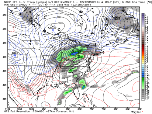
GFS 3-hr precip total, sea level pressure and 5000' temperatures valid at 7AM Wednesday.
The above depiction of sea level pressure and precipitation by the GFS model shows a low pressure to our northeast by 7AM tomorrow. This indicates that we will not have much to deal with in the way of precipitation with the front as the majority of the best lift and moisture remain closer to the low pressure system itself. Lets zoom into the Mid-South with the use of a high-resolution model.

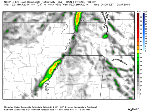
NAM 4-km Composite Reflectivity ("Future Radar") valid at 4AM Wednesday.
The NAM model suggests a brief shower is possible in the early morning hours as the cold front makes its way through the Memphis metro. A shower is also possible overnight while we remain in the warm, relatively unstable air mass.

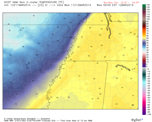
4km NAM near-surface temperatures valid at 6AM Wednesday.
By 6AM the difference in temperature east and west of the Mississippi River is quite dramatic. This shows the potency of the cold front as it progresses east during the morning hours. Expect a drastic drop in temperatures into the 40's around this time tomorrow morning.

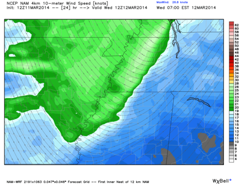
4km NAM near-surface wind speed and direction valid at 7AM Wednesday.
The NAM also shows a distinct wind shift to the northwest typically indicative of a cold front. This occurs as the low pressure to our north progresses eastward, wrapping air around it counter-clockwise. As a result it will be quite windy tomorrow, especially in the morning, making those 40's feel quite a bit colder. Expect decreasing clouds as well as cold, stable air works to reduce cloud cover.

Looking out a little further, temperatures will rebound behind the front as we head towards the end of the week, but not quite to the levels of the past couple of days.  In addition, mornings will be colder as cool, dry high pressure moves overhead.

For details, reference the full MWN forecast at our website.

--William Churchill, MWN Social Media Intern

----
Follow MWN on Facebook, Twitter, and Google+
Visit MemphisWeather.net on the web or m.memphisweather.net on your mobile phone.
Download our iPhone or Android apps, featuring StormWatch+ severe weather alerts!

Tuesday, February 25, 2014

Cold weather returns along with some precip tonight - will winter ever end??

8:00 UPDATE
We are receiving lots of reports of sleet and even a little thunder in the area this evening as freezing levels are low and air fairly dry, promoting sleet development. Temps remain in the 40s at this time and will fall into the 30s, but no travel issues are expected this evening due to sleet.


Following a beautiful weekend that felt an awful lot like spring, I got questions like "is spring finally here?" and "is winter gone for good?"  My response: "It's still February." Alas, Mother Nature is throwing a stark reminder of that our way in the coming week.  The only good thing about cold weather this time of year is that typically it doesn't last as long and isn't QUITE as cold.  Of course that is all relative...  It has been a long and cold winter in the Mid-South!

An Arctic cold front moves through the region tonight, shifting wind to the north and becoming gusty, while also causing temps to plummet.  Meanwhile, some precipitation is expected to move through the area as well.  Computer models differ slightly on the placement and timing of precipitation, but all seem to agree that most of it will fall across north MS, while the southern half of west TN and east AR could see light precip prior to snow-cold air arriving.

Thus, there is a low chance that light rain could briefly change to light snow or sleet for a couple hours after midnight before ending before dawn in the metro. Areas just south of the metro in north MS have a slightly better chance of seeing light snow, but even that is not much.

The latest NAM model output indicates precip falling along and south of the TN-MS line at midnight with the 32 degree line (blue line) dropping south across the metro. A brief changeover to snow is possible if this scenario pans out. Other models keep the precip a little further south.

Temps will fall to the upper 20s by dawn, so any light precip that falls overnight COULD freeze or create black ice on elevated roadways or objects, though a gusty north wind will help in the drying process and most roadways will be plenty warm enough to keep from freezing.  The probability of travel issues in the metro Wednesday morning is low.

Forecast temperatures from the NAM model at 7am Wednesday morning. Wind chills will be in the teens.

Cold air sticks around the rest of the week with highs on Wednesday in the 30s and wind chills in the 20s despite abundant sunshine. Lows Thursday morning drop well into the 20s, perhaps some upper teens in the coldest outlying areas as wind goes nearly calm. Mid to upper 40s are expected Thursday and Friday afternoon and we'll have to monitor Friday morning for possible precip into sub-freezing air, though it appears at this time as though rain would hold off until temps were well above freezing Friday.

Warmer temps (50s and 60s) are expected this weekend with low rain chances before yet another major cold front arrives Sunday or Monday, depending on which model solution plays out.  This front will bring a potential for thunderstorms and then another blast of cold air as we start March off like a lion.  One more time, we'll monitor how fast the cold air moves in on the heels of precipitation departing.  Click here for the complete MWN Forecast, which is highly subject to change for this weekend's system.

NOAA predicts equal chances of above/below normal March temperatures so hopefully we can shed winter and get some spring cleaning done in March!

March 2014 temperature outlook from NOAA indicating below normal temps should stay to our north with equal chance of above and below normal temps across the Mid-South.

----
Follow MWN on Facebook, Twitter, and Google+
Visit MemphisWeather.net on the web or m.memphisweather.net on your mobile phone.
Download our iPhone or Android apps, featuring StormWatch+ severe weather alerts!

Thursday, January 30, 2014

A Mixed Bag: Warm and wet followed by possible winter weather

Overview:
After a much colder than average January for the Memphis metro we'll finally start to see a warmer pattern take shape for the next few days. A building ridge to our east will help bring warmer, moist air into the region into this weekend. As you can probably expect, with any warm flow coming off the Gulf you're also going to get plenty of chances for rain in the forecast. We'll wrap up discussion with a potentially significant system affecting the Mid-South next week (with relatively cold air in the area) before yet another arctic airmass overtakes the region.

January Climate Summary:
Before we talk about the upcoming weather, lets take a look at just how cold this January was.
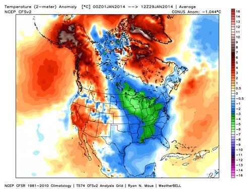
2-meter Temperature Anomalies for (most of) January
The above image shows an average of observed temperatures for the month of January compared to climatology. This indicates that Memphis was nearly 3° Celsius (~5.5° Fahrenheit) below average for the period. Another interesting climate statistic to point out is that Memphis averages 14.5 days out of the month with a low of less than 32°. This January we have had 23 days that meet that criteria! It has without a doubt been a frigid January, so now lets get into the details of the brief warm up.

Weather Discussion:
Significant warming begins today with gusty south winds ushering warmer, moist air into the Mid-South. Expect this to continue through Saturday with rain chances beginning Friday and increasing into Saturday.

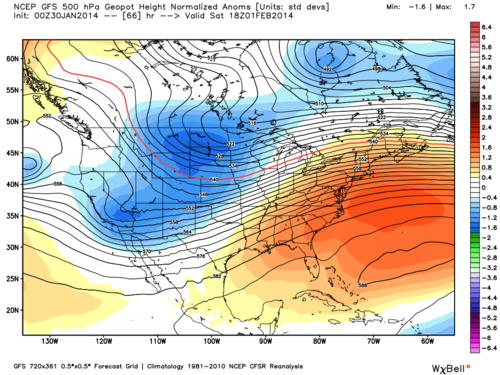
GFS 500 mb Normalized Geopotential Height Anomalies mid-day Saturday
Above is a modeled image of the middle sections of the atmosphere on Saturday. It showcases our warmer pattern with a ridge of high pressure to our east. The broad clockwise flow of this ridge brings warm, moist air from the Gulf of Mexico into the region.

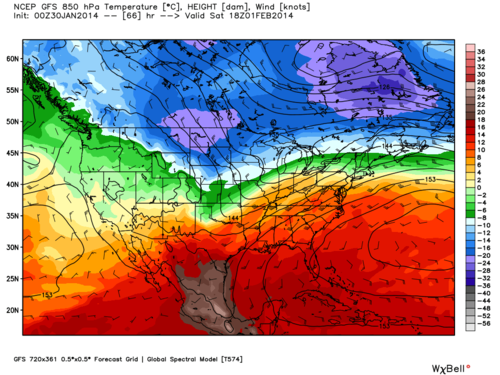
GFS 850 mb Temperatures and Winds mid-day Saturday
The effects of the ridge can be seen in the above modeled image of temperatures in the lower levels of the atmosphere. Relatively warm air can be seen as far north as New England (although snow pack in some of these areas works to prevent these warmer temperatures from reaching the surface).

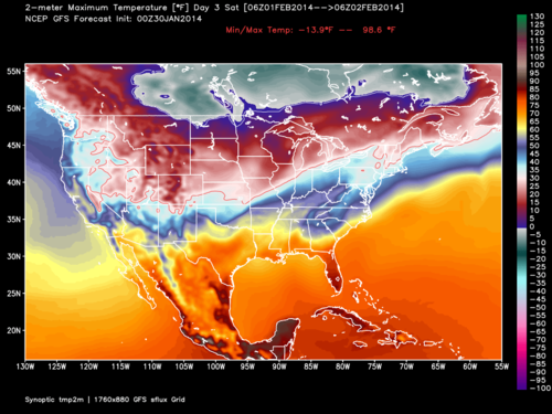
GFS 2-meter Maximum Temperatures for Saturday
Above are forecasted maximum temperatures for the same day, indicating temperatures as high as 60 degrees for the Memphis metro on Saturday.

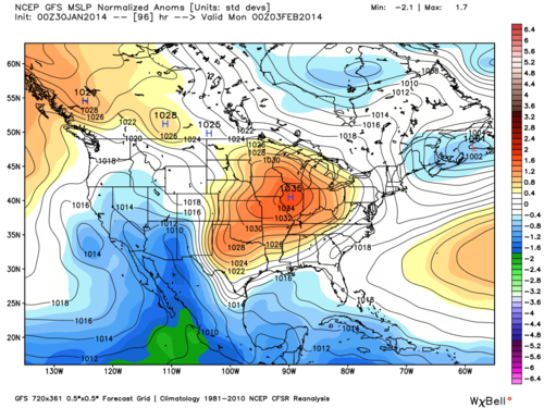
GFS Mean Sea Level Pressure Normalized Anomalies for Sunday night
Unfortunately a brief return to colder (but not frigid) temperatures is expected on Sunday as a cold front moves through the region. The above modeled image shows surface pressure conditions on Sunday evening, with a decent cold core high pressure system over the region. It's important to note that the orange colors do not represent warmer temperatures, but higher pressure values. Since this is a cold core high pressure system, this actually suggests cold temperatures.

Tuesday is where the forecast gets quite tricky, as we have relatively cold air over the area with a low pressure system and its associated precipitation setting up somewhere near the Mid-South.

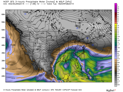
GFS 3-hourly Precipitable Water Values for Tuesday afternoon
Above is a modeled image of precipitable water values mid-day Tuesday. It is basically showing the extent of the deep moisture in the region due to the approaching low pressure system from the Gulf of Mexico. Values are peaking near 1.5 inches which is fairly significant for a potential winter weather event (given that relatively cold air being present at the surface).

Unfortunately I cannot answer all the questions concerning possible winter weather accumulations from this storm system (no one can this far out). This winter weather set up is similar to what we are used to with borderline temperature problems leading up to the event. We will not know for sure the extent of the cold air and the exact track of the low pressure system until the event is actually happening. Both of these things are extremely important as small changes in either factor will lead to huge differences in precipitation types and amounts. However, things will become a bit more clear over the next few days and we'll be sure to let you know when we have a better idea of possible precipitation types and accumulations. As of now we're confident the event will start as rain with a changeover of precipitation possible during the latter half of Tuesday and heading into Wednesday.

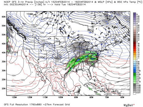
GFS 3-hour Precipitation Amounts and 850 mb Temperatures for Tuesday afternoon
Above is the same weather model's precipitation estimation for late Tuesday morning. This indicates some heavier precipitation is possible with the high amount of moisture present. Currently this model has the freezing line in the lower levels of the atmosphere farther north during the period of heaviest precipitation, meaning mostly rain with perhaps some change over at the end of the event (note that this is just one particular model solution, not a forecast).

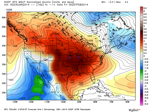
GFS Mean Sea Level Pressure Normalized Anomalies for next Thursday night
One thing I can say with some certainty is that frigid temperatures are likely to return for the first weekend of February. The image above shows a huge area of arctic high pressure building in at the end of the modeled period (once again orange and red colors suggesting high pressure strength, not warm temperatures). Don't let this warm Saturday fool you, winter is certainly not over!

Get full details on the forecast from MWN by clicking here.

-William Churchill, MWN Social Media Intern

----
Follow MWN on Facebook, Twitter, and Google+
Visit MemphisWeather.net on the web or m.memphisweather.net on your mobile phone.
Download our iPhone or Android apps, featuring StormWatch+ severe weather alerts!

Monday, January 13, 2014

Roller-coaster temps this week thanks to mainly dry cold fronts

Temperatures this week will mimic some of the best roller coasters around as multiple cold fronts move through the area.  Fortunately, the fronts will be moisture-starved, bringing little to no rain with them it appears.  The fronts will be noticeable to Mid-Southerners however, marked by cold weather and gusty north wind behind them and warmer days as wind shifts back to south ahead of the next front.  This is what we refer to as a "progressive pattern," meaning that systems do not stall out, but continue moving through every couple of days.  Much like a roller coaster car that doesn't stop in the valley or at the top of the hill, but heads straight for the next loop!

The image below is taken from this morning's GFS (American) computer model showing near-surface temperatures for the next 7 days.  High temperatures for each 6 hour period are in red and low temperatures for each 6 hour period in black.  The daily highs are labelled with the vertical axis on the left indicating the temperatures in degrees F.  Friday morning's low is also labelled as it will be the coldest morning this week.  I'll bet you can even pick out about when the fronts will come through!  Precipitation is represented by blue bars (scale to the right for amounts in inches).  You'll notice that after today's rain (the first 2 blue bars), there is no more precipitation expected from the GFS until early next week, despite the hills and valleys in the temperatures.

GFS Monday morning model data showing temperatures in pink and black (highs and lows for each 6 hour interval, respectively) and precip (blue bars).  Warm temps are expected Tue, Thu, and this weekend, while cold days will be Wed and Fri when highs will probably stay in the 30s!

The official MWN Forecast calls for pleasant days on Tuesday (with a very small chance of a shower as the first front moves through) and Thursday with cold, windy days on Wednesday and Friday.  A moderating trend is expected this weekend.  It looks like another cold snap will arrive early next week.  Overall, a not-unexpected pattern for the middle of winter and thankfully not as cold as the start of last week!

Follow us on Facebook, Twitter, or Google+ for multiple updates each day (links below)!

--Erik Proseus
MWN Meteorologist

----
Follow MWN on Facebook, Twitter, and Google+
Visit MemphisWeather.net on the web or m.memphisweather.net on your mobile phone.
Download our iPhone or Android apps, featuring StormWatch+ severe weather alerts!

Friday, January 3, 2014

Looking ahead to Sunday's Arctic plunge: snow & bitter cold

Temperatures in the lower half of the 30s today will feel like spring warmth by early next week, following an Arctic cold front that moves through Sunday morning. And certainly don't get used to the upper 40s expected Saturday!

Rain chances increase Saturday night ahead of the front being shoved across the eastern U.S. by a massive dome of cold air straight from the north pole.  Rain will be likely Sunday morning with temps in the 40s, however as soon as the front passes through (between 8-11am), cold air pours into the region and we'll reach the freezing mark by noon, if not a bit quicker.  When that happens, rain will change to snow.  The amount of moisture left behind the 32-degree line determine the amount of snow we get.  This is not a case of whether it will get cold enough, because it WILL be cold enough!

Current estimates from various computer models range from a heavy dusting (0.5-0.75") up to a couple of inches.  Our current forecast is for a good inch in the metro, more to the north and less to the south.  It is conceivable that some spots in the metro could see up to 2", however we believe that to be on the high side.  Rain should change to snow by noon with the heaviest prior to 3pm, then flurries possible into the early evening.

European model forecast of precipitation between 6am-noon Sunday and the freezing line at noon (dark blue). MWN believes the cold air might get here an hour or so quicker than this shows. Rain vs. snow is NOT depicted in this image.

European model forecast of temperatures at noon Sunday. Notice how quickly temps transition from 40s to 20s!
The other concern Sunday will be the rapid nature of the falling temps.  Rain that falls before temps reach 32 could quickly freeze on all outdoor surfaces and bridges/overpasses in particular could "flash freeze," meaning that sitting water turns to ice in very short order.  We expect to see temps in the 20s by late afternoon.

This will begin a period of below freezing temps that will last until Wednesday, or as much as 72 hours, including periods of extreme cold (for the South).  Low temperatures in the city will be near 10 Monday and Tuesday mornings, Monday's high will only be in the middle teens, and wind chills Monday morning will drop below zero!  Areas outside the city proper can subtract at least a couple of degrees from those morning low temps. It's been 4 years since we've had lows that cold and maybe as far back as February 1996 since we've seen highs in the teens.

European model graphic of forecast temps and precip through next week. Click for larger image.
Now is the time to prepare for winter weather Sunday and bitter cold for 3 days.  See the graphic below for information from the NWS on cold weather preparation.

Cold weather preparedness from NOAA.  Click for a larger view.
We'll have more information and updates to the forecast on our website, mobile web, and social media platforms, all listed below, in the coming couple of days.  In addition, plan to join us Saturday night at 8pm for a Google+ Hangout on our expectations for the coming several days.  You'll be able to watch live via Google+ or YouTube, or watch a recording after the fact.  Links will be posted on MWN and our social feeds.

----
Follow MWN on Facebook, Twitter, and Google+
Visit MemphisWeather.net on the web or m.memphisweather.net on your mobile phone.
Download our iPhone or Android apps, featuring StormWatch+ severe weather alerts!

Monday, November 11, 2013

Arctic cold front poised to blast through the Mid-South overnight

Our weekend blog discussed this week's "big chill" - this is mainly an update and to remind you that, yes Virginia, weather cold enough for Santa Claus is still coming (though missing one key ingredient, a word I won't mention lest the roads get salted). :-)

At 10am Monday (map below), temperatures have plummeted across the Northern Plains as the front barrels through the Midwest. In fact, near-zero readings were found along the North Dakota-Canada border this morning!

Monday 10am CST temperatures. The Arctic blast is easily noted across the north-central U.S.
The front will continue to dive south, reaching the Memphis area around midnight tonight. Behind the front wind increases considerably from the north (steady at 20-25 mph with gusts to 30+) and very light rain is possible from the early morning through mid-morning hours. As clouds move out by mid-day, sunshine will help to offset the falling temperatures, but the damage will be done.

Look for the mercury to be in the lower 40s on the way to work and not get much, if any, higher all day long. In fact, wind chills will be in the 30s throughout the day!  By dusk, temperatures will begin falling again, reaching freezing by midnight or shortly thereafter as wind lightens. Wednesday morning lows will be in the mid to upper 20s across the metro. In fact, as shown by the high-resolution NAM model below, freezing temps could be found as far south as the central Gulf Coast Wednesday morning!

Widespread teens and 20s will be found Wed morning across most of the eastern half of the U.S.

Wednesday morning lows in the southern U.S., as projected by the high-res NAM. Note the sub-freezing temps as far south as Louisiana and southern MS and AL!
Because the immediate metro (Shelby County) and points west and south have not experienced a freeze yet, and temperatures of 28 or less are likely for all but the city itself (where lows will still drop below freezing), a Hard Freeze Watch is in effect from 9pm Tuesday through 9am Wednesday for these areas.  Tipton, Fayette, and Marshall Counties are NOT included as these areas have already experienced a freeze and the growing season has ended, even though they will also be well below freezing (more on why this is).  Everyone with outdoor vegetation that is sensitive to a freeze should take precautions to protect those plants Tuesday and Wednesday nights.


Fortunately, a warming trend begins by Thursday afternoon, though most areas will drop below freezing again Thursday morning. A mild and more unsettled pattern looks to emerge for the weekend. Details can be found in the MWN Forecast.

----
Follow MWN on Facebook, Twitter, and Google+
Visit MemphisWeather.net on the web or m.memphisweather.net on your mobile phone.
Download our iPhone or Android apps, featuring a fresh new interface and StormWatch+ severe weather alerts!

Saturday, November 9, 2013

Holy cold snap, Batman! Major Canadian air intrusion poised to dive south

As we approach mid-November, we've had a fair number of cold fronts that have dropped overnight lows near or below 40, some places in outlying areas (especially to the northeast of the metro) have touched freezing, and we've had some days with highs only in the 50s. However, the first official "winter is getting closer" cold front is due in on Tuesday, so get out those heavy coats if you haven't yet!

A very cold airmass residing over north-central Canada is poised to make a run into the central portion of the U.S. then continue to dive south into the southeast U.S. as a major trough sets up over the eastern half of the nation.  This will bring our coldest temperatures yet this fall and likely drop everyone - including those in the warmest parts of the Bluff City - below freezing Wednesday and Thursday mornings.

Let's take a look at a couple of representations of the cold air infiltration. First, from the European model, showing the temperature anomalies (departure from normal) at ~5,000' up (below).  Keep your eye on the purple area (coldest temps relative to normal) in Canada as it drops south into the Mid-South. The loop begins Saturday morning and ends Thursday morning.  (All graphics below courtesy of WeatherBell.com.)


Next, we look at the European model's U.S. counterpart, the GFS, for a little closer look.  Below we see near-surface temperatures (actual, not departure from normal) beginning Sunday evening and running through Thursday morning. Pretty easy to spot the leading edge of cold air as it dives south.


A few snapshots of near-surface temperatures from the European model show it's projections for Tuesday afternoon maximum temperatures and Thursday morning low temperatures.  Note that actual daily high temperatures on Tuesday will probably occur at midnight (maybe near 50), with temps falling throughout the day.

European model forecast maximum temperatures between noon-6pm Tuesday (the high for the day will likely occur at midnight, with temperatures falling throughout the day).
European model forecast minimum temperatures for Thursday morning. 
One big question that people always ask (and it's never too early in the year to ask it, of course) when major cold airmasses move into the region is the chance of precipitation, especially hoping for some good news (or bad depending on your point of view) about "non-liquid" precipitation.  I kept my mouth shut on this a couple of days ago -- though trust me, I was looking -- when the European model seemed to think some "non-liquid" precipitation might fall.  I knew it was too early in the season and models tend to moderate as they get closer to an event.  Alas, I was right, they have.

Below is the expected RAINFALL amounts from the cold front during the morning hours on Tuesday.  You'll notice by the amounts (trace to a couple of hundredths) that the amounts are minimal.  This will NOT be a major rain maker.  I can also tell you that it is ALL LIQUID.  You're going to have to wait until deeper in the season for something of the non-liquid variety.

Expected rainfall amounts on Tuesday morning with this cold front are very light.
The bigger story, besides the falling temps, will be the wind. In the wake of the front, Tuesday's wind will be out of the north in the 10-20 mph range at least, with gusts possibly as high as 30+ mph. Below is the forecast wind chill values at 6pm Tuesday from the GFS -- in the 20s area-wide!

Wind chill readings in the 20s are forecast early Tuesday evening as north wind reaches as high as 20-30 mph.
Bottom line:  Plan for a significant outbreak of Canadian air mid-week behind a Tuesday morning cold front that will drop temperatures through the 40s Tuesday, bring light rainfall during the morning, as well as 20-30 mph wind throughout the day. Lows Wednesday morning will be in the 20s to near 30, highs Wednesday (despite sunshine) will likely remain in the 40s, even cooler temperatures are possible Thursday morning, then conditions moderate back to near normal as we head towards the weekend.  The complete forecast can be found on MemphisWeather.net and our mobile apps.

So, are you ready for some cold weather (even for a couple days) or are you already longing for summer warmth?

----
Follow MWN on Facebook, Twitter, and Google+
Visit MemphisWeather.net on the web or m.memphisweather.net on your mobile phone.
Download our iPhone or Android apps, featuring a fresh new interface and StormWatch+ severe weather alerts!