Another arctic air mass is already affecting the Mid-South with frigid conditions expected through Wednesday night. Gradual warming is expected each day, building to the 50's expected Friday.
I'm sure most of our followers know by now that quite the rare winter weather event is setting up for a good portion of the Gulf and Atlantic coasts. It is fairly frustrating to be north of where the wintry action is taking place, so lets breakdown why that is.
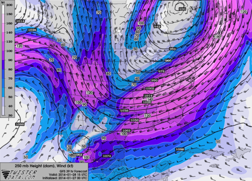 |
| 18z GFS 250 mb (jet stream level) heights and wind speeds for Tuesday morning |
Above is an image showing wind speed and direction in the upper atmosphere. Depicted is a large area of winds in excess of 160 mph stretching all the way to northern portions of the Mid-South. This screaming jet streak is providing plenty of energy to the upper atmosphere that supports clouds and precipitation. You can actually see in the image a southern and northern component to the jet stream in the Mid-South. This is the subtropical jet and polar jets phasing together to create a very strong single jet stream. So it's not surprise that when this happens there is usually an area that gets nailed with heavy wintry precipitation (in this case the Carolina's).
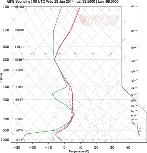 |
| 18z GFS atmospheric sounding valid for Tuesday evening |
The above image is a modeled vertical profile of the atmosphere which puts into perspective our main problem here in the Mid-South for those who want snow. By Tuesday evening, dew points (green line above) could be less than -20 degrees Celsius, which indicates extremely dry, arctic air being pushed in from the north. This very dry air at the surface is the main reason we won't see snow (although flurries are a possibility). As snow begins to form and falls towards the surface in Memphis, it will inevitably evaporate in the dry air towards the surface. Farther south and east there is a better mixture of the wind energy and moisture that support larger snowfall totals.
 |
| 18z GFS valid for midday Tuesday showing 2-meter temperatures |
So finally we get to the real story in the Mid-South which is frigid arctic air. Above is a temperature anomaly map which shows temperatures as low as 20 degrees below normal during the day tomorrow. In fact, almost the entire eastern and central United States are well below average as the arctic air overtakes the region.
To break it all down in terms of a temperature forecast, expect a 10 degree rise in high temperatures each day. Mid 20's tomorrow, 30's Wednesday, 40's Thursday and 50's Friday. Of course the mornings will still be rather chilly (especially tomorrow and Wednesday with temps in the lower teens). Get full details on the forecast from MWN by clicking
here.
-William Churchill, MWN Social Media Intern
----
Follow MWN on
Facebook,
Twitter, and
Google+
Visit
MemphisWeather.net on the web or
m.memphisweather.net on your mobile phone.
Download our
iPhone or Android apps, featuring
StormWatch+ severe weather alerts!

No comments:
Post a Comment