
Two shots of cold air are on the agenda with the second later week blast being more potent than the first. Temperatures are expected to be below average the entirety of the week with some relief possible by the weekend. Lets get into the details of work-week, double-cold snap.
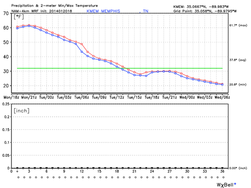 |
| NAM-4km Min/Max Temperature and Precipitation Graph through midnight Tuesday night |
Beyond the scope of the graph, temperatures will continue to drop Tuesday night into the teens before attempting to rebound during the day Wednesday to the lower 40's. This is due to the progressive nature of the weather pattern which shifts winds back to the southwest, aiding the sun in warming us to tolerable winter levels.
However, also typical of progressive patterns is quick shifts back to cold before too much warming can happen. This is exactly what we see Wednesday night with the passage of another arctic front, quickly dropping temperatures back into the lower 20's, then struggling to reach 30 on Thursday.
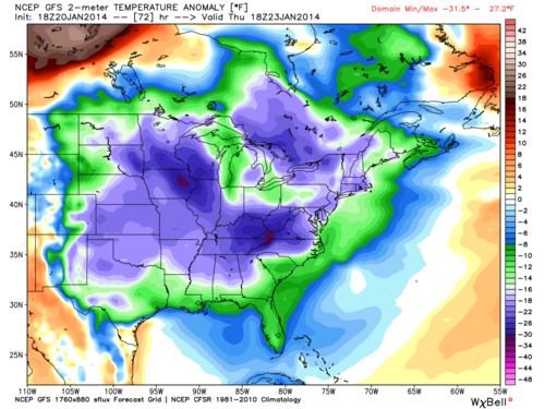 |
| GFS 2-meter Temperature Anomaly valid for midday Thursday |
The situation does not get any better Friday as the progressive nature of the pattern slows down as north winds continue to usher cold air into the region on Friday. [Editor's note: thanks, William, for not calling this the "second coming of the polar vortex."]
As previously mentioned some relief is possible heading into the weekend but we're not too optimistic. So I hope you enjoyed the beautiful warm winter day today as the cold looks to lock in for awhile!
For the complete MWN forecast, with details on exactly how cold it'll be this week, click here or check our MWN mobile apps featuring StormWatch+ nationwide mobile weather alerts.
--William Churchill (MWN Social Media Intern)
----
Follow MWN on Facebook, Twitter, and Google+
Visit MemphisWeather.net on the web or m.memphisweather.net on your mobile phone.
Download our iPhone or Android apps, featuring StormWatch+ severe weather alerts!
No comments:
Post a Comment