Showing posts with label earthquake. Show all posts

Wednesday, November 17, 2021

Magnitude 4.0 earthquake felt in Memphis metro

While the New Madrid seismic zone is known to produce literally hundreds of micro-quakes each year, it is rare that any are felt noticeably throughout the Memphis metro. However, on Wednesday night at 8:53pm, the New Madrid fault produced what we believe to be the strongest earthquake in 16 years, a magnitude 4.0 tremor that was centered deep in the earth's crust just northwest of  Poplar Bluff, MO. 

A seismograph from  Lake Charles, AR clearly recorded the motion of the earthquake. (USGS)

While certainly not as strong as the quakes that caused the Mississippi River to "flow backwards" in the winter of 1811-1812, reports were quickly received of jolts and rumbles across the metro. The last time a quake this strong occurred on the New Madrid fault was May 1, 2005, a magnitude 4.2 centered near Manila, AR, east of Jonesboro. 

The community-based "shake map" clearly shows the earthquake was felt over a large area. (USGS) 

More information on the earthquake, as well as a page that allows you to report if you felt it, can be found on the event page from the U.S. Geologic Survey. So while it was a noticeable event for many in the metro, it is a reminder that we live on the southern edge of an active fault and should be prepared, just in case. This time, we're simply glad that it wasn't any worse... and hoping it is not a pre-shock to "the big one."


Erik Proseus
MWN Meteorologist

----
Follow MWN on Facebook and Twitter for routine updates and the latest info!
Complete MWN Forecast: MemphisWeather.net on the mobile web or via the MWN mobile app
Download our iPhone or Android apps, featuring StormWatch+ severe weather alerts!
MWN is a NOAA Weather Ready Nation Ambassador Meteorologist Erik Proseus is an NWA Digital Seal Holder

Wednesday, August 26, 2015

MWN Lightning Round: awesome local weather, a west TN quake, KMEM is StormReady, and a note on T.S. Erika


Decided it would be a good idea to hit a few topics all at once today, so here comes another edition of the MWN Lightning Round!

Awesome weather week

I don't know many people complaining about this week's weather. For late August, you can't be disappointed with morning lows in the 50s for many, afternoon highs in the mid 80s, abundant sunshine, and low dewpoints! We have one more day to copy/paste that forecast, then humidity starts creeping back up as wind shifts back to the south.

By this weekend, we'll be back to "near normal" for this time of year - lower 90s afternoons, lower 70s morning, and a little more humidity. The good news is there still is no appreciable rain chance in the 7-day forecast. Looking further out, NOAA thinks the first 10 days or so of September will feature slightly higher rain chances and above normal temperatures (which means 90s). Don't worry, this week's weather will be back before long! Fall is not too far away!

Temperature outlook for September 3-9, 2015, which shows a 70% probability of above average temperatures in the metro during this period. Summer may not quite be done!

Tipton County Earthquake

Tuesday morning at 8:26am, a magnitude 3.5 earthquake struck the Mid-South, centered a few miles north of Covington in Tipton Co. There were many reports of people feeling the tremor, especially north of the metro, including Lauderdale County. Fortunately, it was too weak to cause damage, but it is a good reminder that the New Madrid fault lies very near the area. For those of you who saw our post on Twitter and Facebook (below) and shared, commented, or liked it, thanks. It was all in good fun (especially since there were no major ramifications). The post went viral with over 100,000 views in 24 hours (and climbing). :-)

We stand with Tipton County. #TNQuake #TiptonStrong
Posted by MemphisWeather.net on Tuesday, August 25, 2015


Memphis International Airport becomes StormReady

About a month ago, Memphis International Airport (KMEM) achieved an important designation. No, not the first airport with a "Grit and Grind" spokesperson, but the first airport in Tennessee (and  only the 16th nationwide) to earn the "StormReady" designation from the National Weather Service. From the Airport Authority newsletter, the designation is "for demonstrating excellence in the preparation and planning for severe weather."

Jim Belles, Meteorologist in Charge of the NWS's Memphis Forecast Office; Cedric Simon, Memphis Int'l Operations Duty Manager; Stephen Kearney, NWS meteorologist; Terry Blue, MEM Vice President of Operations; and Gary Woodall, NWS Warning Coordination Meteorologist. Photo courtesy MSCAA. 
According to the National Weather Service, "StormReady helps arm America's communities with the communication and safety skills needed to save lives and property--before, during and after the event. StormReady helps community leaders and emergency managers strengthen local safety programs."  So the next time severe weather threatens the airport, rest assured that airport officials have a plan and are ready to execute it at a moment's notice to keep patrons and operations safe.

Tropical Storm Erika struggling, but has potential

As of Wednesday afternoon, Tropical Storm Erika is being affected by moderate to strong wind shear as it moves towards the Caribbean. This shear has weakened the storm and will continue to affect it for a couple of days. However, if Erika can survive the shear, much more conducive conditions await as the storm approaches the Bahamas, and potentially Florida, in a few days.

Computer models have narrowed in on a track that takes the storm north of Puerto Rico and into the Bahamas this weekend, while also strengthening it as it leaves hostile conditions behind. From there, it's difficult to say what Erika will do, but those along the Florida east coast will need to closely monitor the system. Multiple scenarios take Hurricane Erika up the east coast of Florida early next week.

NHC Forecast track for T.S. Erika as of Wednesday afternoon. The last forecast point just off the Florida east coast is valid Monday afternoon and indicates a hurricane with 75 mph  maximum sustained wind.
By the way, Saturday marks the 10-year anniversary of Katrina's landfall on the Gulf Coast. That year, 2005, was also the last time a major (category 3+) hurricane made landfall in the U.S., a 10-year drought that is unprecedented in the modern era. Hate to say it, but we're overdue. For the latest information on Erika, see the MWN Tropical Page.

Erik Proseus
MWN Meteorologist

----
Follow MWN on Facebook, Twitter, and Google+
Visit MemphisWeather.net on the web or m.memphisweather.net on your mobile phone.
Download our iPhone or Android apps, featuring StormWatch+ severe weather alerts!

Thursday, April 2, 2015

No foolin' tremor jars Mid-South on April Fool's Day

Revised 8:30am - USGS indicates the magnitude has been reduced to 3.6 from an initial report of 4.0

April Fool's went out with a bang, or perhaps a rumble, yesterday as the New Madrid Fault Zone briefly reminded Mid-Southerners of its presence.  A magnitude 3.6 earthquake occurred in the far southern Missouri Bootheel at 10:52pm last night.


Yes Kristen it did! From social media reports and reaction to our posts on Facebook and Twitter, there were lots of folks that felt the tremor in the Memphis metro. Here's the quake page for this event from the USGS, which indicates that it occurred at 10:51:43pm on April 1 4km (2mi) S of Steele, Missouri (or about 80 miles north of Memphis) at a depth of 10.9km. There appear to be no initial reports of damage.

The New Madrid seismic zone of southeast Missouri and adjacent States is the most seismically active in North America east of the Rockies, according to the USGS and an unconfirmed report indicates that this was the strongest quake east of the Rockies since February 5, 2014.

Location of the April 1 earthquake relative to Memphis

The "Did You Feel It?" map from USGS indicates a lot of folks did!


So, did YOU feel it? 


As an aside, HUGE thanks to MWN intern Kevin Terry who was all over this event as it occurred lat night and got the info out quickly on our social media accounts. Admittedly, I slept through it... another great example why #TeamMWN is the best around!


Erik Proseus
MWN Meteorologist

----
Follow MWN on Facebook, Twitter, and Google+
Visit MemphisWeather.net on the web or m.memphisweather.net on your mobile phone.
Download our iPhone or Android apps, featuring StormWatch+ severe weather alerts!

Wednesday, July 17, 2013

Minor earthquake rumbles northeast AR Wednesday afternoon

A minor earthquake, centered just southwest of Trumann, AR, occurred at 3:10pm CDT Wednesday afternoon.  The epicenter of the magnitude 3.2 quake was 44 miles northwest of downtown Memphis and it's depth was 8.5 miles below the earth's surface.  According to the USGS, "weak shaking" was felt by a number of individuals in the immediate vicinity of the quake, but it was not felt even in nearby Jonesboro.  The location is on the southwest tip of the New Madrid Fault zone which extends from this area northeast into the A short video of the location of the quake with respect to the Memphis metro is shown below (Flash required), or click here for a direct link to the video.


The USGS "Did You Feel It?" map is below, showing the latest reports of where the quake was felt, and how strongly.

Though difficult to read, a helicorder (device used to measure ground shaking) just west of Trumann, AR picked up the earthquake.  The helicorder plot below is read left to right, top to bottom, with each new line colored alternating colors (green, black, red, blue) and each line representing 15 minutes.  The black squiggles circled in yellow began at 3:10pm CDT and indicate the shaking occurring from the Trumann quake.  The helicorder readout shown below is operated by the Center for Earthquake Research and Information at the University of Memphis. Click the image for a full size view.

Helicorder display from a station just west of Trumann, AR.  The shaking from the Trumann quake is easily seen.

 ----
Follow MWN on Facebook, Twitter, and Google+ Visit MemphisWeather.net on the web or m.memphisweather.net on your mobile phone. Download our iPhone or Android apps, featuring a fresh new interface and StormWatch+ severe weather alerts!

Saturday, March 12, 2011

Follow-up on Japanese quake & Pacific tsunami and spring weather in the Mid-South

Following the massive "Great Quake" in Japan on Thursday night and subsequent tsunami that affected nearly the entire Pacific basin, I posted some interesting images and links on Twitter and Facebook.  I thought I'd take a minute to recap those if you missed them.

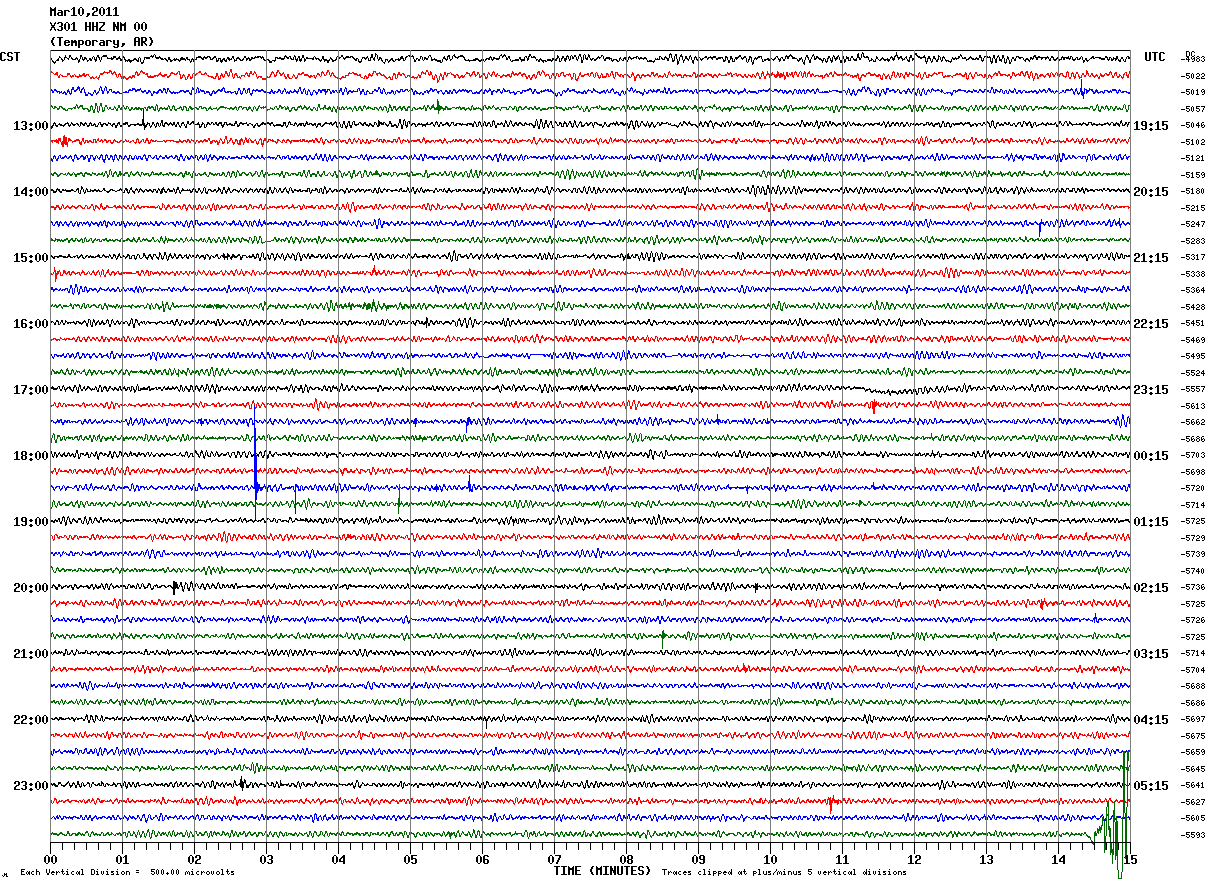
First, helicorders in northeastern Arkansas detected the earth's movement halfway around the globe from Japan. The first picture is from a "normal" day with almost no ground movement.  (The lines read from left to right, top to bottom, and each line represents 15 minutes.)  You'll notice at the very bottom right of the image, some shaking is detected - this is shortly before midnight Thursday night.  The second image is from Friday. Wow!  Though the earthquake wasn't "felt" in Arkansas, it was certainly detected by the sensitive instrumentation.

Thursday, March 10, 2011

Friday, March 11, 2011

Next, an image from the West Coast and Alaska Tsunami Warning Center showing the propagation forecast of the tsunami waves (note, 30 centimeters = 1 foot).


And to see that tsunami "in motion," check out the video animation below provided by the NOAA Center for Tsunami Research.  Thanks to Ryan Vaughan (KAIT-TV, Jonesboro) for digging this one up! It's eery to watch.


As for the aftermath, here are a couple of links to photos and video I found and shared yesterday.  There is just SO MUCH information and video/imagery that this is just a small sampling.  If you have some favorites you would like to share, leave them in the comments so that I and my readers can check them out!

50 Stunning Pictures of the Japan Earthquake and Tsunami
Massive Wave Flattens Buildings in Japan (YouTube)

Switching gears.......
Locally, we're in for a GREAT spring day! The sky will be mostly sunny with a high near 70 and a steady southwest wind today. A low chance of showers appears tomorrow as a weak cold front moves into the area. Additional cloud cover will hold temperatures back 7-8 degrees from today's readings. A better chance of rain and isolated storms will be possible Monday as an upper-level system moves through the region. Highs will be back in the 50s. Outside of a couple of small rain chances, next week will see a warming trend with highs into the 70s for mid to late week. For those on Spring Break and staying in the area, it should be a good week to get out and enjoy Mid-South spring! For the complete MWN forecast, click here.

Also, remember that tonight we "spring forward" to Daylight Savings Time.  Move the clocks ahead one hour, change the batteries in your smoke detectors AND in your NOAA Weather Radio. Then, be ready to see the sun a little longer into the evening!

---- Stay up to date on the latest weather conditions and forecast by checking out MemphisWeather.net on Facebook and Twitter and our BRAND-NEW iPhone app!

Monday, October 11, 2010

A week of earthquakes for northern AR

Seems the area north of Little Rock, AR, has become the Mid-South hotspot for earthquakes of late! According to the US Geologic Survey, there have been nearly four dozen small quakes all near the same location in north-central AR, north of Conway near the town of Guy. The largest, a magnitude 4.0 which was felt across a large part of northern Arkansas, trembled this morning shortly after 8:30am CDT, and was followed a few hours later by a magnitude 3.6. More information on these quakes, including coverage by a couple of excellent weathermen from The Natural State, click on the links below:
----
Get the latest weather conditions and much more by checking out MemphisWeather.net on Facebook and Twitter!

Monday, January 18, 2010

Earthquake threat in the Mid-South

New Madrid Fault System, image courtesy UM-CERI

With all of the recent earthquake activity across the globe, I thought it would be a good time to review the earthquake threat that the Mid-South faces on a daily basis. Though not specifically weather-related, earthquakes fall into a broader "geography" or "earth sciences" category, of which meteorology is also a part. Therefore, it is appropriate to address here.

In the past 7 days, there have been 49 earthquakes of magnitude 5.0 or higher across the globe. A world map view shows that many are centered around the well-known and very active Pacific Rim. While this may be something akin to "normal," what has caught my attention are the number of magnitude 6.0 or higher earthquakes. On the 10th, a magnitude 6.5 occurred just off the northern California coast. And we all know about the 7.0 that struck Haiti on Jan. 12. That was followed by fourteen aftershocks of magnitude 5.0 or higher - all less than 24 hours after the initial quake - and dozens of smaller ones. One the 14th, a 6.0 rumbled southwest of Guam in the western Pacific. While this region is frequented by tremors, a 6.0 is still pretty strong even for the Pacific. On the 18th, another strong 6.3 quake occurred in the Drake Passage (between South America and Antarctica, south of Argentina). Finally, this morning, another 6.0 struck near the Guatemala/El Salvador coast. (All information above courtesy USGS.gov.)

We should be reminded that we live very near the New Madrid Fault System, which produced one of the strongest earthquakes in U.S. history 199 years ago (1811) and has the greatest earthquake risk east of the Rockies. A Fact Sheet published by the USGS details the continuing threat that this fault poses. In addition, an urban seismic hazard mapping report for Memphis was published by USGS in 2006 which may be of interest.

I would invite you to use this opportunity for education - know what you need to do to be prepared should an earthquake strike and what to do during and after a quake. The Fact Sheet quoted above indicates that the region could see landslides along the river bluffs, "ground failures [...] including soil liquefaction along the Mississippi River floodplain," impassable roadways due to bridge collapse or fissures in the road surface, disruption of agriculture and farmland flooding that could contaminate water sources, and failure of levees and riverbanks. With it's aging infrastructure, Memphis is "particularly vulnerable when subjected to severe ground shaking," including the possibility of building failure due to their being built prior to the writing of code that require seismic resistance.

None of this is meant to cause fear or worry, but instead to serve as a reminder that education and preparedness are key. Who knows when "the big one" may strike, but there is no indication that sometime in the future it won't.

For more information, visit these links:

United States Geological Survey Earthquakes Homepage

Earthquake Preparation - Before, During, and After an Earthquake (FEMA)

USGS Earthquake Notification Service

USGS Earthquake Info for Kids

University of Memphis Center for Earthquake Research and Information (CERI)

CERI's New Madrid Fault System page

Central U.S. Earthquake Consortium

ABC/Good Morning America Story (Jan. 18. 2010) on the central U.S. earthquake risk

----
Get the latest weather conditions and much more by checking out MemphisWeather.net on Facebook and Twitter!