Showing posts with label drought. Show all posts

Saturday, October 8, 2022

The good and bad of prolonged dryness, and when rain will fall again

The big weather story for the Mid-South is the arrival of beautiful fall weather that has stuck around for a few weeks now. While fortunate in that we can enjoy some terrific weather and not worry about rain-out's, the flip side is that drought is once again taking hold on the region, affecting everything from allergies due to dust and other foreign debris in the air to Mississippi River traffic that is severely limited by low water.

The Drought Monitor for this past week shows expanding dry conditions across the region, including Moderate Drought in the southern and western metro. (UNL Drought Monitor)


Precipitation the past 30 days

The last 30 days or so has featured one "round" of precipitation - scattered storms on Saturday evening, September 24 that brought very heavy rain to some and little to none for others. A look at the 30 day rainfall anomalies (below) shows that much of the region, especially west of the river, has received less than 25% of normal precipitation in the past month - in fact much of Arkansas has not had a drop of rain.

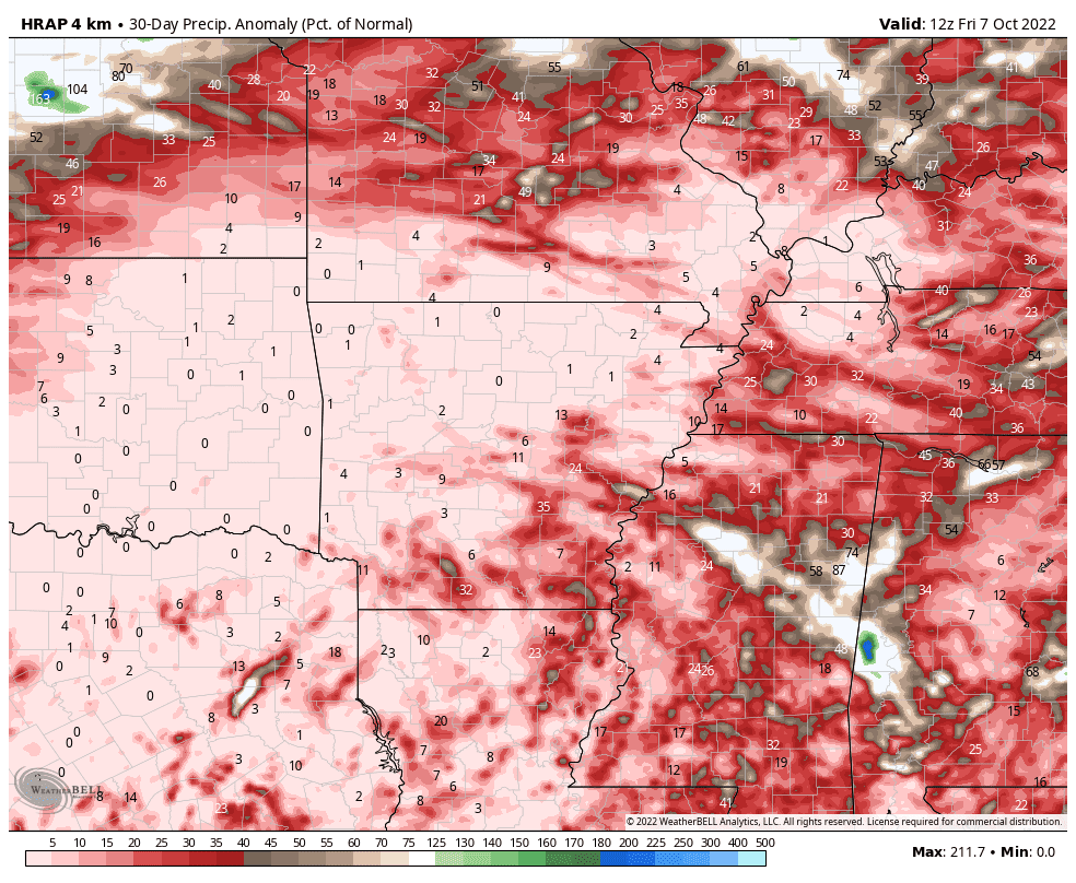
Rainfall anomalies (as a percentage of normal) for the past 30 days are significantly below normal, in fact near 0% for much of AR into OK and TX and well below 50% for our area. (WeatherBell)

Effects on the Mississippi River

The bigger picture is that the lack of precipitation throughout the Mississippi and Missouri River Valleys has resulted in water levels on the river that are in the top 10 lowest on record. Barge traffic has been reduced to a trickle through our area, which is starting to affect supply chain, particularly for agricultural goods that flow south on the river from harvested land in the Midwest. The lowest reading of late was -.8.2 feet on October 3, which ranks 7th lowest on record. While up just a bit, the river is forecast to get that low again within some much-needed rainfall, especially up-river.

The hydrograph for the Mississippi River at Memphis points to water levels well below the "low stage" of 5 feet, running between 5-8 feet below zero so far this month. Projections are for water levels to remain historically low well into October. (NWS/AHPS)

Looking ahead

In the wake of another dry cold front on Thursday evening, we are once again enjoying an amazing weather weekend with sunshine, highs in the 70s, and crisp mornings. Today (Saturday) will likely be the coolest day in Memphis since April, and tonight, all Mid-South residents will see temperatures drop into the 40s, while some frost will be possible in northern reaches of the Mid-South. 

The week ahead features a warming trend ahead of another cold front that arrives early Thursday. We'll be back in the low 80s Monday, then the mid 80s for the mid-week period, though low dewpoints will allow for mornings to still be pleasantly cool for a few days. By Wednesday, clouds will increase, as will humidity, setting the stage for a decent chance of precipitation for many of us. The most likely timeframe for rainfall will be Wednesday night (satisfying many of you who would like rain, but not during the day so you can enjoy the fall weather!). A few thunderstorms cannot be ruled out as dewpoints climb into the mid 60s. While projected rainfall totals aren't overly impressive, anything will help at this point! 

Forecast precipitation from the National Weather Service through mid-day Thursday.  About one-half inch is forecast in the metro. Here's hoping we all get that much, or more! (WeatherBell)

Behind the front, sunshine returns Thursday and continues into next weekend, with another shot of cool weather as well. Highs will be back in the 70s through next weekend with morning lows in the 50s. 


There are signs of an even bigger cool down about 10 days out as we get deep into mid-October, but we'll see how that plays out. In the meantime, we've got one decent chance of rain late Wednesday into early Thursday to plan around, otherwise Fall Break looks pretty good!

Erik Proseus
MWN Meteorologist

----
Follow MWN on Facebook and Twitter for routine updates and the latest info!
Complete MWN Forecast: MemphisWeather.net on the mobile web or via the MWN mobile app
Download our iPhone or Android apps, featuring StormWatch+ severe weather alerts!
MWN is a NOAA Weather Ready Nation Ambassador Meteorologist Erik Proseus is an NWA Digital Seal Holder

Thursday, November 10, 2016

Fall is here! Details on the forecast, drought, and frost/freeze dates

Fall is definitely here! Lows in the urban core this morning were just above 40°, but most areas outside the city were in the upper 30s while the coolest areas dropped into the mid 30s. On the northern outskirts of Bartlett, MWN recorded a low of 35° and we saw our first frost of the year on patchy spots on the grass and sheltered rooftops. More on that in a minute, but first...

The next few days...

Very nice fall weather continues today and Veteran's Day with highs near 70° and plenty of sunshine. A weak cold front moves through Friday night and helps to reinforce the cooler and drier air. Saturday's temperatures start in the mid 40s and only climb to about 62° with a northeast breeze. If you're going to the Memphis Tigers football game Saturday evening, you'll want to prepare for cool temperatures with a kickoff temperature in the mid 50s, falling to near 50° during the game.


Drought status

A bit of rain on Tuesday barely put a dent in the ongoing drought conditions. The map below shows the percentage of normal precipitation over the past 60 days. The Memphis area is near 25% of normal. Areas to our southeast are even worse. In fact, today Birmingham set an all-time "no rain" record. It's been 53 days since their last measurable rainfall!


The current drought conditions for the Mid-South are shown below. The drought intensity in the metro is unchanged for the past few weeks, continuing in "moderate drought" conditions. The lack of rainfall and recent warm weather will likely have a muting effect on (and delay) the fall colors in the trees. Burn bans continue in MS with some firer restrictions in west TN.

Remainder of November

Looking ahead, the long-range forecast through Thanksgiving shows pleasant temperatures that remain above normal through much of the next week, followed by a fairly significant frontal system late next week that should cool us down again heading into Thanksiving week. (Average highs this time of year are in the mid 60s and lows in the mid 40s. By Thanksgiving, we should be seeing highs near 60°.) The official MWN Forecast can be found anytime in our mobile apps or on our website.

First frost/freeze data

An additional note on first frost and first freeze conditions. Memphis International Airport's average first occurrence of 32° is this Saturday, November 12. At the Agricenter it is November 7. We'll definitely be late this year as above average temperatures continue. (For the record, the latest "first freeze" at the airport is December 11.)


Frost is a little more tricky as temperatures, wind, and moisture all play into whether frost forms. A breezy morning with a low of 33° won't produce frost, but a low-lying area with no wind and clear sky could see frost in the upper 30s. The National Weather Service uses 36° as a proxy for "first frost," which is reasonable. The average first frost at Memphis International is November 2, while at the Agricenter it is October 25.


More frost, freeze and snow records can be found on MemphisWeather.net.

Veteran's Day appreciation

Finally, a word of thanks to all of those who have served this country in the armed forces, whether in peace time or war, and those who continue to serve. We appreciate your sacrifices and those that your families make on a daily basis and will support you in whatever way we are able! In fact, be sure you're following us on Facebook or Twitter (links below) as we'll be giving away free MWN apps to our friends that are active duty or retired service members, as well as first responders, on Friday as a small token of our appreciation! Thank you and God bless!

Erik Proseus
MWN Meteorologist

----
Follow MWN on Facebook, Twitter, and Google+
Visit MemphisWeather.net on the web or m.memphisweather.net on your mobile phone.
Download our iPhone or Android apps, featuring StormWatch+ severe weather alerts!
MWN is a NOAA Weather Ready Nation Ambassador Meteorologist Erik Proseus is an NWA Digital Seal Holder

Thursday, November 3, 2016

Cold front tonight! Cooler temps but not much rain

A brief post as we await tonight's cold front...

As temperatures reach record territory for the third day in the past six (85° at 2:38pm breaks the previous record of 83° set in 2012), we are eagerly aniticipating the arrival of a cold front this evening. The front will drop temperatures 10° or so on the highs and as much as 15-20° for overnight lows as dewpoints drop enough to let cool mornings set in. This will make it feel much more comfortable, but will actually still be above average for this time of year. Average highs are in the upper 60s, while average lows are in the upper 40s.

Mid-afternoon high-res model imagery showing scattered showers developing along the cold front as it moves through the metro this evening. Anything that falls is likely to be fairly brief. (If image doesn't loop, click here and select the Memphis metro from the menu.) (WxBell)
On the down side, not much rain is expected with the front. Scattered showers, and maybe a brief rumble of thunder, are expected this evening, but not everyone will get rain and few will see enough to be considered "beneficial." We recommend grabbing the umbrella just in case if you have outdoor plans this evening.

Over the past 90 days, very little precipitation has occurred across the southeast U.S. outside of the hurricane zone along the eastern seaboard (see image below). The metro sits at about 50% of normal, and much of that actually occurred in August, with very little rainfall in the past couple of months. This has resulted in a moderate drought for the immediate area, while places to our southeast (where rainfall has been less than 25% of normal) are in very bad shape when it comes to drought.


90 day precipitation anomalies for the interior southeastern U.S. from the NWS show a dearth of rainfall, which has contributed to extreme drought conditions in some areas. (weather.gov)

Dry weather is expected to continue throught the weekend into next week with high pressure aloft over the southeast U.S. remaining firmly entrenched. This will keep temperatures above normal, though more pleasant than the past several days (mostly in the 70s for highs). Referencing our last blog post, there still looks to be a more significant pattern shift coming after the middle of November. Stay tuned.

For the latest forecast information, as well as current conditions and MWN StormView Radar, download the MemphisWeather.net mobile app or visit us on the mobile web.

Erik Proseus
MWN Meteorologist

----
Follow MWN on Facebook, Twitter, and Google+
Visit MemphisWeather.net on the web or m.memphisweather.net on your mobile phone.
Download our iPhone or Android apps, featuring StormWatch+ severe weather alerts!
MWN is a NOAA Weather Ready Nation Ambassador Meteorologist Erik Proseus is an NWA Digital Seal Holder

Friday, October 21, 2016

Gorgeous fall weather, drought status, and winter outlooks

See?? I wasn't lying! Cool fall weather really did make it into the Mid-South! Most of us woke up to temperatures that started with a "4" this morning for the first time in over five months and, despite full sunshine, we're only going to get to the mid 60s for highs today. After a long, hot summer that seemed to be never-ending, it has. I for one am grateful. If you're going to be out this evening, take along a jacket as temperatures will quickly drop into the 50s with sunset.

Metro temperatures as of 6am this morning. (MWN)
If you were on the cusp of turning on the furnace this morning, tomorrow morning's temperature might just push you over the edge. Morning lows will be about 5° cooler with 40-45° temperatures expected metro-wide. In fact, it's possible that a few 38-39° readings could occur in low-lying rural areas well removed from the urban heat island tonight, particularly to the east. Frost likely won't be an issue in the metro, but it won't be far away! For Saturday, it'll be a tad warmer, but a high of 70° is still phenomenal and welcomed!

NWS-Memphis predicts the possibility of frost across eastern portions of west Tennessee and north Mississippi early Saturday morning. (weather.gov/memphis)

Inevitably, of course, there is a rebound, but at least this time we're not talking about mid to upper 80s and noticeable humidity. By Sunday afternoon, after another chilly start with lows in the 40s, temperatures rebound into the upper 70s as wind shifts southerly. In fact, the "warmth" of the next week or so will be highs near 80° with lows moderating back up close to 60 by mid-week. Believe it or not, that is still a fair amount "above normal" as average highs drop towards the 70° mark in about a week. No significant rain chances exist in the coming week either. Clouds increase mid-week as a weather system moves by well to our north, but rain chances continue to be minimal.

Average temperatures for the month of October in Memphis.
Departure from normal temperatures for the past 30 days in Memphis. Nearly every day has seen an average temperature above average, and most well above average. (NWS)

Drought Status

Speaking of lack of rain, drought conditions continue to worsen in the past couple weeks with all of the metro except Crittenden County now classified as being in a "moderate drought." Rainfall has been minimal for nearly two months now, despite being well above average for the year thanks to wet conditions for the first half of the year.

The latest drought monitor shows moderate drought conditions in the metro and extreme drought expanding in east-central MS. (droughtmonitor.unl.edu)

Observed precipitation for the past 90 days in Memphis. From late July to late August, precipitation was well above average, but there has been little precipitation recorded since the first of September. (CPC/NCEP)

Winter Outlook

Yesterday, NOAA, the parent organization of the National Weather Service, released their 2016-2017 Winter Outlook. I've included the graphics below, but you can click here to read the full story. In a nutshell, weak La Nina conditions are likely to be one of the primary drivers of the weather patterns this winter. La Nina is a cooling of the equatorial ocean waters west of the South American coastline. It tends to result in drier and warmer than average conditions across the southern U.S., with the Mid-South on the northern fringes of that region.

Specifically, NOAA gives us about a 40% chance of above average temperatures for the December through February period. Precipitation is forecast to have "equal chances" of being above or below average. In other words, there is no clear signal of either condition occurring.


The other outlooks that I have perused are fairly well in line with NOAA, with perhaps a trend from above normal temperatures earlier in the winter to near or slightly below average to end the winter. Snow is always a tough call - and the most asked question of course - but because our average snowfall for the year is basically one storm, and zero or two would be "abnormal," it's simply too difficult to know how much we'll get. A few mile difference in a storm track could make the difference between an above normal and below normal year! It'll be interesting to see how it plays out for sure.

Erik Proseus
MWN Meteorologist

----
Follow MWN on Facebook, Twitter, and Google+
Visit MemphisWeather.net on the web or m.memphisweather.net on your mobile phone.
Download our iPhone or Android apps, featuring StormWatch+ severe weather alerts!
MWN is a NOAA Weather Ready Nation Ambassador Meteorologist Erik Proseus is an NWA Digital Seal Holder

Friday, July 8, 2016

Heat & drought, storms, then more heat

June was hot - the seventh hottest on record in Memphis. July is continuing that trend. In fact, as of 8am this morning, the official reporting station at Memphis International Airport had not dropped below 80° in 72 hours and that streak will continue today and likely until early Saturday morning when the forecast low is 79°.

Overall, it's also been dry, though some places have received the benefit of scattered thunderstorms dropping heavy rain in localized areas over the past month. Areas just to our south and across the interior southeast are dealing with very dry conditions - drought in many cases. North Mississippi, including the southern metro, is on the edge of that drought area.

Precipitation anomaly (departure from normal) over the past 90 days shows large areas of the southeast U.S. with a deficit of multiple inches of rain through the spring and early summer. Graphic courtesy WxBell.


Short-term drought (appearing in the last 6 months) is present throughout the interior southeast with greatest effects in northern GA/AL and the southern Appalachians. A close-up view of MS is shown below, indicating dryness into the southern metro (Tate, Tunica, and Marshall Co's). Graphics courtesy US Drought Monitor.


As we head into the weekend, some much-needed rain is expected, though we are hopeful that severe weather does not accompany it. A weak cold front will be located just north of the metro with the possibility of storm systems riding along the front through the area. They will feed on the very unstable air that is in place south of the front, driven by the heat and humidity. The good news, I suppose, is that increased cloud cover and rain in the area should hold temperatures down just a bit this weekend.

A weak cold front will stall over the Mid-South this weekend, becoming a focus for possible convective complexes with a chance of strong storms and heavy rain.
If a storm complex or two (called MCC's, or mesoscale convective complexes) forms, they tend to continue through the night, not ending when the sun goes down. This scenario is very unpredictable beyond about 12-24 hours, thus nailing down timing of potential storms this weekend is difficult.

The atmospheric pattern that favors these complexes will be partially in place however, with a general northwest to southeast flow at the mid-levels (what we call "northwest flow"), a weakness in the mid-level pressure pattern developing over the area, shortwave troughs (or upper air disturbances) moving near the region, and plenty of heat and moisture to feed the storms.

The GFS model of pressure at the 500mb (18,000') level at 7pm Saturday shows wind flow "ridging" over high pressure over NM with wind flow from northwest to southeast across the Mid-South. This is what is referred to as "northwest flow" and is a favorable pattern in the summertime for convective complexes to follow that wind flow. Graphic courtesy Pivotal Weather.
The first of these storm clusters or complexes appears to skirt the northern metro early this evening according to this morning's high-resolution short term models. Thus, for what I think is the third time this week, areas just to our north are under a risk of severe weather, as forecast by the Storm Prediction Center. As of 2pm, the risk is in category 2 of 5, or Slight Risk, with the main period to monitor being late afternoon to early evening. The primary severe weather threat will be damaging wind. Northeast AR and northwest TN have the best chance of storms with the tail end of the storms possibly reaching as far south as I-40 in the metro.


Heading into the weekend, we'll simply advise that you keep a close eye on the forecast and our social media feeds as severe weather cannot be ruled out Saturday, Sunday or Monday while the front hangs over the area. Again, timing of storm complexes, or just pop-up storms, is nearly impossible to pinpoint right now. A few storms could get strong enough this weekend to produce areas of damaging wind or large hail, as well as very heavy rain.

The one time period that has a little higher confidence level on is overnight Saturday night into early Sunday. Multiple models have depicted storms developing during that period. We're hopeful that they hold off until after Saturday evening outdoor activities have wound down, including the Levitt Shell ticketed event featuring Sharon Jones and the Memphis Redbirds Christmas in July evening with baseball, fireworks, and Santa (I wouldn't want to be the one in the Santa suit outside in July)!

By early next week, upper level ridging (high pressure) begins building back into the region, pushing the thunderstorm threat back to our north and allowing mid-summer heat to rebuild with highs back in the mid 90s and heat indices above 100. The long-range outlook for the third week of July is predicted to have a high likelihood of more "above normal" temperatures. Hang in there and stay cool!

The week 2 outlook from NOAA's Climate Prediction Center indicates a 70% chance of temperatures remaining above normal. In other words, a respite from the summer heat doesn't appear to be in the offing during this period!

Erik Proseus
MWN Meteorologist

----
Follow MWN on Facebook, Twitter, and Google+
Visit MemphisWeather.net on the web or m.memphisweather.net on your mobile phone.
Download our iPhone or Android apps, featuring StormWatch+ severe weather alerts!
MWN is a NOAA Weather Ready Nation Ambassador Meteorologist Erik Proseus is an NWA Digital Seal Holder

Thursday, October 22, 2015

Relief from drought as a wetter pattern returns to the Mid-South

The last couple of months in the Mid-South have seen very little rainfall and what rain has fallen has not been well-distributed, leading to lengthy dry periods and the development of "abnormally dry" conditions. "Severe drought" conditions lurk just to our southwest in the Mississippi Delta.

Total rainfall for the past 60 days across the south reveals a lack of precip along the lower Mississippi Valley and back into eastern TX. Graphic courtesy WeatherBell.
Conditions are "abnormally dry" across the metro with severe and extreme drought just to our southwest.

In fact, at Memphis International, after a wet start to August, there have been just a few days with enough rainfall to really matter much, and almost none since mid-September. If you throw out September 9th with just over 1" of rain, less than 0.25" has fallen since September 1 and only 0.03" for the month of October!

Precipitation accumulation (green) since August 1 at Memphis Int'l vs. average (brown). Memphis is now 6" below average for the year.
However, Mother Nature tends to have a way of balancing out over the long haul and this weekend will likely make a dent in the rainfall deficit. Unfortunately for those who count on nice fall weather this time of year for outdoor activities, many could be impacted by the rain.

Weekend outlook

Upper level ridging (or high pressure) that has influenced the Mid-South this week is transitioning to a southwest flow pattern, bringing moisture into the area from Hurricane Patricia off the coast of Mexico. Also, an upper level low that has been over the southwest U.S. begins to lift into the central portion of the country. This combination will mean increasing rain chances a bit as we head into the afternoon and evening hours on Friday. Fortunately the rain appears light.

Friday night into early Saturday could see higher rain chances as an upper level disturbance moves across the area, though scattered showers are the most likely outcome. The Saturday forecast has been the trickiest all week and computer models still don't have a good handle on the situation, leading to lower confidence than I would like in the forecast.  It appears that the heaviest rain could fall just north of the metro, but there's a good chance we'll see more scattered showers or periods of light rain during the day. We're not expecting a complete washout, but there could be multiple periods of rain. Also, mid-level instability will rise a bit on Saturday afternoon so we can't rule out a few rumbles of thunder as well.

National surface map for Saturday evening showing the approaching frontal system and moisture from Texas moving north along the front and across the Mid-South.

Saturday night could be wet as a cold front moves into the region and stalls out, which could lead to periods of rain, perhaps moderate at times. These showers will linger into Sunday as the front remains in the area, though once again computer model data is less than convincing on the amount of rain to expect. The NWS indicates that we could see a total of 1-2" of rain by Sunday evening for much of the area with beneficial (and perhaps too much) rain across much of the drought areas in the Southern Plains and areas west of the Mississippi River.

Forecast rainfall amounts from the NWS through Sunday evening. Flooding will be a concern in TX and southern OK while beneficial rain is expected in the Mid-South. Graphic courtesy WeatherBell.

Remnants of Patricia

Also this weekend, as we're dealing with rain locally, Hurricane Patricia will make landfall in western Mexico with remnants expected to cross northern portions of the country and emerge in the western Gulf of Mexico early next week. After doing so, what could be a subtropical low will strengthen off the Texas coast and move northeast. In doing so, it could very well end up moving across the Mid-South.

Model solutions for the low associated with Hurricane Patricia, indicating a northeast track, possibly right into the Mid-South. Graphic courtesy WeatherBell.
Timing on this system is still TBD, but we'll be keeping an eye on Tuesday and Wednesday fairly closely. Should it track across the region, periods of heavy rain and some gusty wind could well be the result, putting a bigger dent in the lingering rainfall deficit as we close out the month of October. Stay tuned!

For the latest forecast information, check out MemphisWeather.net, MWN Mobile web, and our mobile apps, as well as our social media feeds.

Erik Proseus
MWN Meteorologist

----
Follow MWN on Facebook, Twitter, and Google+
Visit MemphisWeather.net on the web or m.memphisweather.net on your mobile phone.
Download our iPhone or Android apps, featuring StormWatch+ severe weather alerts!

Monday, August 20, 2012

Trouble on the Mighty Mississippi continues

The Dredge Hurley, owned by the U.S. Army Corps of Engineers.  Photo courtesy  USACE/Memphis District.
Low water continues to cause trouble on the Mississippi River at Memphis.  This morning's stage of -8.5 feet is a slight drop from yesterday.  The forecast is for a continued slow drop to -9 feet by this weekend.  River forecasts can be found on MemphisWeather.net here.

Army Corps Dredging River Near Memphis 
The U.S. Army Corps of Engineers is using a 350-foot-long dredge to make the Mississippi River near Memphis easier for barges and boats to navigate.

The Corps is using the dredge to remove sediment from the Mississippi River’s bottom as it tries to maintain the river’s vital navigation channel. The dredge, called the Hurley, is currently working at Redman Bar just north of Downtown Memphis.

Engineers have been dredging sections of the river near Memphis because its low water level could pose a hazard to barges and tow boats that transport material down the river. Officials say the river is running several feet below normal.

The Hurley can dredge to a depth of 75 feet and can remove up to 5,000 cubic yards of sediment per hour.

– The Associated Press

The American Queen docked on Mud Island in Memphis this month; its owners decided not to send the boat below Memphis on a trip to Vicksburg.  Photo credit: Jim Weber/The Commercial Appeal.

----
Visit MemphisWeather.net on the web or m.memphisweather.net on your mobile phone.
Download our iPhone or Android apps,  now with StormWatch+!
Nowcasting services available on our Facebook page and Twitter feed.

Saturday, August 11, 2012

Drought improves in some areas, not in the Mid-South

The metropolitan area remains entrenched in a severe to extreme drought this week.  Below are comparison maps for the south-central U.S., as well as Tennessee, Mississippi, and Arkansas, for this week versus 4 weeks ago.  While areas that were not under severe conditions showed some improvement over the past month, areas like the metro that need rain the most are slowly getting worse.

South-central U.S. drought conditions have improved somewhat in the past 4 weeks, especially over east TX, the Gulf Coast, and middle and eastern TN. OK and AR have gotten much worse.


Much of middle and eastern TN is no longer in a drought state, though extreme west TN has gotten worse.  Shelby and Tipton County are now in an extreme drought.

North MS is also extremely dry, with little change in the past months, while a minor drought over southern MS ended  in the past month.  

The state of AR is in dire straits with over 50% of the state under "exceptional drought" conditions.
It takes a while to end drought conditions. Above is the amount of precipitation required from August-October to end the current drought.  Not sure we'll see 20" of rain in 3 months, especially given the outlook below!
With expectations for "near normal" precipitation in the Mid-South from August-October, it appears drought conditions will continue into autumn.  Average precipitation for Memphis for these 3 months is 10".

----
Visit MemphisWeather.net on the web or m.memphisweather.net on your mobile phone.
Download our iPhone or Android apps,  now with StormWatch+!
Nowcasting services available on our Facebook page and Twitter feed.