
A severe weather outbreak, producing multiple strong tornadoes from a small handful of supercell thunderstorms, affected the Memphis region on the evening of March 31-April 1. A total of 14 tornadoes touched down in the Memphis County Warning Area (CWA), which encompasses west TN, northeast AR, the Missouri bootheel, and north Mississippi. Three of these tornadoes were rated EF-3 and another five were EF-2. The graphic below summarizes their tracks.
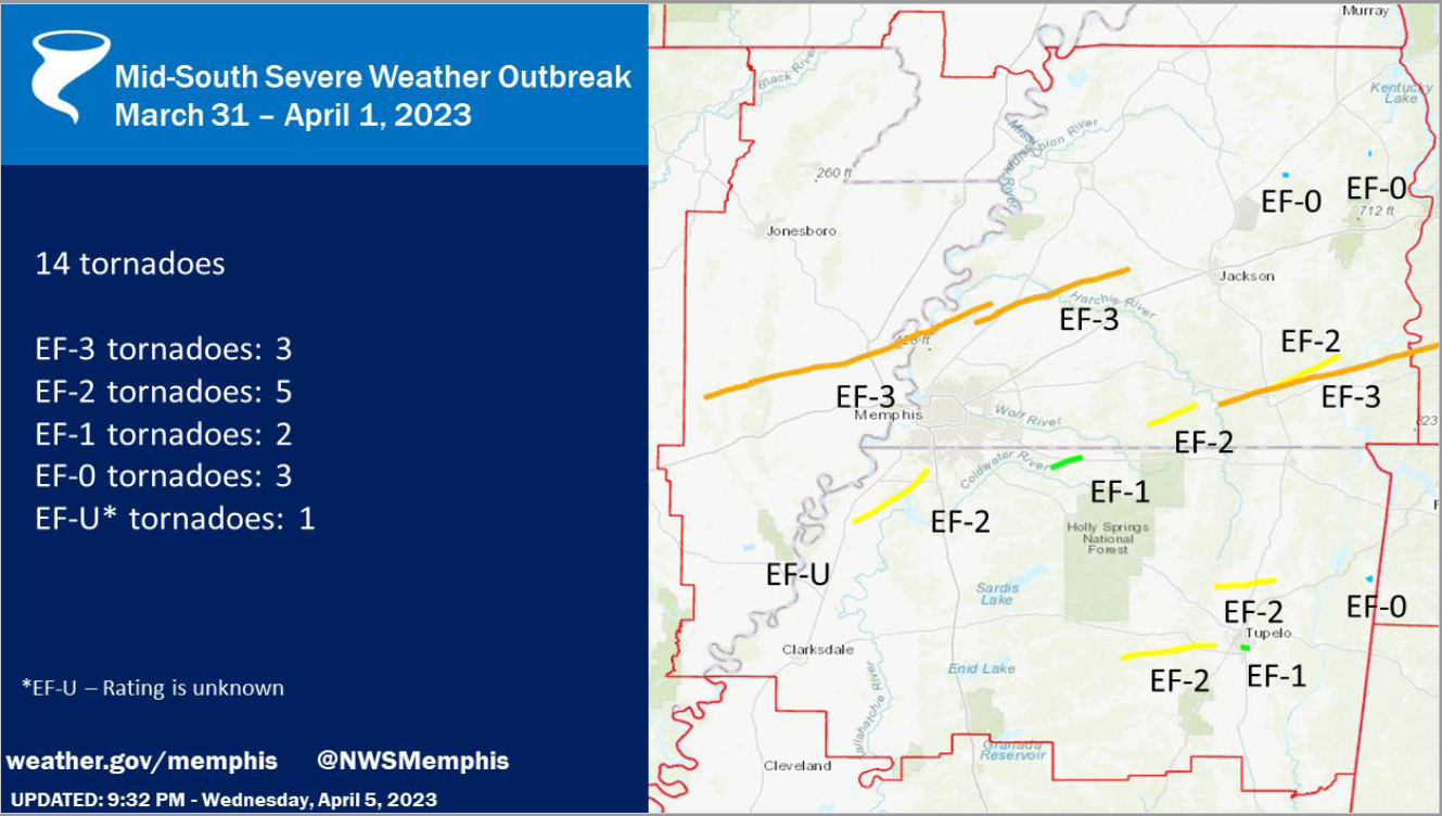
Within the eight-county Memphis metropolitan area covered by MemphisWeather.net (MWN), there were four tornado paths. Detail on each of these is summarized below. More detailed information from NWS-Memphis on all 14 tornadoes can be found here.
Cross/Crittenden/Tipton County Tornado
Rating: EF-3
Est. Peak Wind: 150 mph
Path Length: 73.00 miles
Path Width (max): 1600 yards (0.91 miles)
Fatalities: 4
Injuries: 26
Start Time: 4:30pm
End Time: 5:54pm
Approx. Speed: 52 mph

Summary:
The "Wynne Tornado" touched down in western Cross County, AR at 4:30pm, spawned by the same supercell thunderstorm that resulted in tornado damage in North Little Rock earlier. The storm moved quickly east-northeast across Wynne with EF-3 strength, ravaging Wynne High School and destroying multiple residences. Slightly weaker, it passed north of Earle, AR (Crittenden Co) and crossed farmland before regaining EF-3 strength as it crossed Corna Lake in far western Tipton Co (west of the Mississippi River) before crossing the river and producing EF-2 damage in Wilder Farms (Tipton Co), eventually lifting near Burlison.
Tipton/Haywood County Tornado
Rating: EF-3
Est. Peak Wind: 150 mph
Path Length: 39.53 miles
Path Width (max): 2000 yards (1.14 miles)
Fatalities: 1
Injuries: 28
Start Time: 5:48pm
End Time: 6:29pm
Approx. Speed: 58 mph

Summary:
The "Covington Tornado" originated from the same supercell thunderstorm as the Wynne tornado, and touched down six minutes before the Wynne tornado lifted, meaning the supercell produced twin tornadoes for that six-minute period over Tipton Co. This tornado touched down at 5:48pm just northwest of Munford and moved quickly northeast while increasing in strength as it approached Highway 51 south of Covington. Several homes and businesses were completely destroyed and many more were significantly damaged. Fifty-three power poles had to be replaced along Highway 51 south of Covington. The elementary and middle schools sustained heavy damage, as did additional homes along Highway 54. A couple of large metal power poles were bent to the ground as the tornado widened to a mile in width as it moved across rural area east of Covington. It continued east-northeast across farmland and Hatchie River wetland before weakening and eventually lifting north of Brownsville in Haywood Co.
Tunica/DeSoto County Tornado
Rating: EF-2
Est. Peak Wind: 130 mph
Path Length: 22.87 miles
Path Width (max): 1200 yards (0.68 miles)
Fatalities: 0
Injuries: 0
Start Time: 7:31pm
End Time: 8:02pm
Approx. Speed: 47 mph

Summary:
The "Prichard-Nesbit Tornado" touched down just northeast of the Tunica airport, moving northeast, mainly through rural areas of Tunica and DeSoto Co. Snapped and uprooted trees were observed in Tunica and southwest Desoto county. Roof damage occurred after passing thru the Arkabutla bottom, with extensive tree damage and damaged or destroyed homes noted west of Highway 301. Between Baldwin & Fogg Rd there was EF-2 damage and the tornado dissipated southwest of Nesbit.
Marshall County Tornado
Rating: EF-1
Est. Peak Wind: 95 mph
Path Length: 8.13 miles
Path Width (max): 100 yards
Fatalities: 0
Injuries: 0
Start Time: 8:27 pm
End Time: 8:37 pm
Approx. Speed: 50 mph

Summary:
An EF-1 tornado touched down in Marshall county west of Highway 311, moving northeast before dissipating about ten minutes later northeast of Slayden. Primary damage was to hardwood trees that were snapped or uprooted, while one home also sustained roof damage.
Shelby County Damaging Wind
Finally, MWN surveyed the Sea Isle area of southeast Memphis, near I-240 and Mt. Moriah Road leading into the area of Quince and Estate, as well as American Way between Getwell and Mt. Moriah Roads. Over this large area, many mature hardwood trees were uprooted or had large branches snapped by strong wind. Trees were observed to have fallen on houses, vehicles, and power lines/poles, resulting in additional damage and thousands of customers without power. Near American Way and Getwell, a high-voltage transmission tower was bent over (though a photo of the tower prior to the storm suggested that it may have had preexisting damage that had weakened the structure). In addition, there were three fatalities, including two children, due to a tree falling on their home on South Edgewater Road in the area of Memphis International Airport.
Given the scattered nature of the damage and no "ground path" observed, the damage was due to straight-line wind on the edge of a strong supercell that moved by just to the east of this area into Germantown. The National Weather Service and NEXRAD radar corroborates that this damage was caused by up to 85 mph wind generated by the "forward flank downdraft" of the supercell.
MWN Meteorologist
----
Follow MWN on Facebook and Twitter for routine updates and the latest info!
Complete MWN Forecast: MemphisWeather.net on the mobile web or via the MWN mobile app
Download our iPhone or Android apps, featuring StormWatch+ severe weather alerts!
 |  |
| MWN is a NOAA Weather Ready Nation Ambassador | Meteorologist Erik Proseus is an NWA Digital Seal Holder |


