Sunday, June 5, 2011

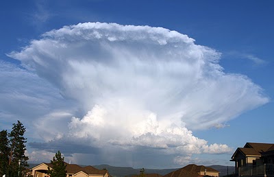
Severe Thunderstorm Safety


There are typically almost 2,000 thunderstorms in progress around the world at any given time.  Only a small fraction (less than 1%) are classified as severe.  Severe thunderstorms are those that produce hail at least 1" in diameter (quarter-sized) and/or wind gusts of 58 mph or greater.

A small fraction of severe thunderstorms produce tornadoes, but all thunderstorms are capable of producing deadly lightning.  The frequency of lightning or amount or duration of rain have nothing to do with whether a thunderstorm is classified as "severe."  Severe thunderstorms can produce straight-line wind as strong as some tornadoes and can produce damage over a much wider area.

Severe thunderstorm and lightning safety rules include:
  • Find shelter immediately.  Go to a sturdy building that will withstand high wind.
  • Avoid electrical appliances and corded telephones.
  • If possible, bring your car inside a garage and secure loose objects.
  • Tune in to local broadcast information or another trusted source to listen for any updates, including the possible subsequent issuance of a Tornado Warning.  NOAA Weather Radio is the preferred source for all severe weather warnings.
  • Incorporate the 30/30 Rule during a lightning storm, whether it is severe or not. If the delay between lightning and a subsequent clap of thunder is less than 30 seconds, seek shelter, then wait 30 minutes after the last thunder to resume outdoor activities.
  • If on a boat, return to shore and seek shelter, at least in an enclosed metal vehicle.
  • If caught outdoors during a lightning storm, avoid being the highest point in the immediate area and avoid metallic objects, including non-enclosed vehicles (motorcycles, bicycles, golf carts, farm equipment). Avoid lone trees and the tallest trees, as they could be the object struck.
A Severe Thunderstorm Watch means that conditions are favorable for the development of severe thunderstorms, but none has been observed.  Keep an eye on the sky and listen for subsequent warnings.

A Severe Thunderstorm Warning means that a severe thunderstorm is occurring or imminent and has been detected by Doppler Radar or reported to the National Weather Service by a trained spotter or law enforcement agency in that area.  Exercise the safety tips above.

----
For weather information for Memphis and the Mid-South, where and when you need it, visit MemphisWeather.net on the web, m.memphisweather.net on your mobile phone, download our iPhone or Android apps, or visit us on Facebook or Twitter.

Friday, June 3, 2011

Hazy and hot will be joined by humid - and it's only the beginning of June!

The Mid-South is in the throes of weather normally reserved for August as the 3 H's (heat, haze, and humidity) are combining to make things miserable across the region. The heat began last Saturday as we started a streak of 90-degree days that right now seems to have no end. With a week of 90-degree weather and persistent high pressure aloft sitting directly over the Mid-South, hazy conditions have also joined in.

Humidity has also been on the rise each day, but until today has dropped enough in the afternoons to keep the heat index near or below 100. As the humidity starts to climb though, heat indices will reach 105+ today through the weekend (at least).  This has prompted the issuance of a Heat Advisory through 10pm tonight and we will likely see advisories continue through the weekend as high temperatures remain in the upper 90s into next week.

Interestingly, the earliest 100-degree reading ever seen at Memphis International Airport was on June 6 in 1977.  Though 100 is not in the forecast, there is a small chance we could touch the century mark this weekend.  If we do that, it'll be the earliest 100 degree temperature ever in Memphis.


The hazy part of the 3H formula can be seen in the snapshot from FOX-13's downtown SkyFox cam shown above and is due to increasing levels of ozone and pollution trapped in the lower atmosphere under sinking air created by persistent high pressure overhead.  Without much wind, the pollution sits in place rather than being dispersed. Ozone is chemically created from pollutants from cars, factories, and other industry reacting in the presence of sunlight and heat. It then becomes a pollutant (more on ozone basics).

For today, the level of ozone is forecast by the Shelby County Health Department Air Quality Improvement Branch is high enough that a Code Orange Ozone Advisory has been issued.  Code Orange means that the air is "Unhealthy for Sensitive Groups," including those with respiratory problems under normal circumstances (asthma, lung disease, etc.) and active adults and children and the elderly.  The Health Department urges everyone to reduce time spent outside and limit prolonged exertion, reduce trips and carpool, and schedule outdoor activities in the morning and evening, avoiding the hottest part of the day.

For more information on ozone and air quality, visit the following links:


----
Stay up to date on the latest weather conditions and forecast by checking out MemphisWeather.net on Facebook and Twitter and our new iPhone and Android apps!