Showing posts with label excessive heat. Show all posts

Sunday, July 17, 2022

Comparing the summers of 2022 and 1980, and what's ahead for the coming week

July 1980 vs. 2022

It's no secret that heat has been a major story locally, and also for much of the country, this summer. If you've seen the daily climate summaries we post on social media each evening, you may be seeing a lot of record highs from the year 1980. Those who have spent all or most of their lifetime in the area will be glad to tell you about ridiculously hot that summer was. 

With 13 days that have reached the century mark so far this summer, and more likely to come, some comparisons are being drawn to the benchmark for Memphis summers. I decided to do a quick comparison of the two summers, in particular the months of July. Here's what I found when running the numbers for the first half of July 2022 versus the month of July 1980:


As you can see, if the pace we have set in the first half of the month continues (and none of us want it to of course), the average temperature for the month will fall within a degree of 1980. The average high temperature for the month is actually higher for the first half of July 2022 than it was for July 1980, while the overnight lows this month have been a couple of degrees cooler than they were in 1980. Through the 16th though, both months had the same number of 100 degree days so far in their respective summers. However, 1980 went on to reach the century mark 20 more times! I sincerely hope that is not what we have in store this year!

This heat is partially due to the lack of precipitation... and that lack of precipitation, particularly over the past month, has resulted in a rapid-onset drought. Comparing the Mid-South drought maps for mid-June versus just four weeks later in mid-July tells the tale:


Rain chances with a "not so hot" front

High pressure ridging that has dominated for much of the first half of July is taking a brief rest in our area the next couple of days as it repositions to the west. That is allowing a front to move into the area, bringing decent precipitation chances over the next 24 hours. The highest probability will be tonight as what appears to be a semi-organized system moves in from the northwest ahead of the cold front. Showers and thunderstorms will be likely, with heavy rain for some and perhaps a few strong wind gusts roughly north of I-40. 

With the front lingering across north MS on Monday, rain chances could linger into the morning, then we'll have another chance of a few thunderstorms in the afternoon and evening too. Clouds will keep high temperatures closer to average as local thermometers take a break from the 100 degree mark. While today's high will be mid to maybe upper 90s, Monday should be in the lower half of the 90s.

The Sunday morning HRRR forecast radar from 7am Sunday to 7am Tuesday shows highest rain chances, accompanied by thunderstorms, Sunday evening/overnight, then lingering chances Monday into Monday night as the front stalls out. (WeatherBell)


Heat returns by mid-week

As we head towards mid-week though, upper level high pressure will start building back into the Mid-South from the west. Temperatures soaring well above 100 in the southern Plains are a harbinger of the heat to come as the ridge noses over the area, squashing rain chances. Look for daily high temps at or just above the century mark Wednesday into next weekend. And since the early week front never really moves all the way through the area, drier air will remain to our north, so humidity will make it feel even hotter than the temperature would indicate. Look for Heat Advisories once again while heat indices climb above 105. 

There are hints of a weak front late Wednesday, but at most it will bring an isolated shower then maybe ever-so-slightly drier air to end the week. Unfortunately, we appear destined for more 100 degree days this month, adding to the total for 2022. Continue to exercise caution in the hot weather and always look before you lock!
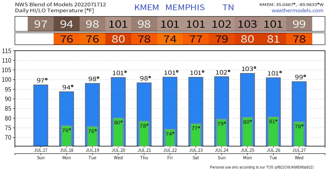
The National Weather Service "Blend" model forecasts the excessive heat to pick back up where it left off by the middle of this week, and continue for probably another week. (NWS via WeatherModels.com)

Erik Proseus
MWN Meteorologist

----
Follow MWN on Facebook and Twitter for routine updates and the latest info!
Complete MWN Forecast: MemphisWeather.net on the mobile web or via the MWN mobile app
Download our iPhone or Android apps, featuring StormWatch+ severe weather alerts!
MWN is a NOAA Weather Ready Nation Ambassador Meteorologist Erik Proseus is an NWA Digital Seal Holder

Saturday, June 11, 2022

Summer arrives - quickly and with ferocity

Recap of Northwest Flow Week

The past week or so has seen the Mid-South region in a pattern frequently referred to as "northwest flow," which means that the upper level wind flows from northwest to southeast across the area. There are two main features of northwest flow in our area, and they are related: 
  1. Storm systems moving out of the central plains threaten the area. They commonly form into mesoscale convective systems (MCS's) and can deliver quite a punch if you are in their path (think Hurricane Elvis and others).
  2. It is a very unpredictable pattern, in which the development, path, and demise of the systems can be hard to know more than a day or so in advance.
The image above shows departure from normal precipitation for the past week. While the Memphis area was fairly close to average, areas in eastern OK and western AR saw the brunt of heavy rainfall, while areas to our east also were above normal. (WeatherBell)

Overall we seem to have come through unscathed, as most either side-swiped the metro or fell apart before getting here. We got some rainfall but not excessive amounts, though a few downpours occurred, and temperatures stayed relatively mild due to the accompanying cloud cover of nearby systems. That pattern has ended today and we are quickly transitioning to a new one - the mid-summer "death ridge."

Arrival of the Death Ridge

Given its name because the strength of upper level high pressure (referred to as a "ridge" of high pressure when it is at upper altitudes) kills off pretty much all rain chances, the "death ridge" as it is colloquially known results in persistent heat, low cloud coverage, and thus minimal precipitation probabilities. Today is transition day as that ridge expands into the area. 

The European model for the next 10 days shows anomalously high pressure build east over the southeast U.S. and southern Plains this weekend, then persist through most of the forecast period. that "death ridge" will be responsible for excessive heat and mainly dry conditions. (WxBell)

While not overly hot - in fact, just near average - it will be much warmer than the average day in the past week and you'll notice it. (Remember that yesterday at noon we were barely up to 70 degrees with light rain falling.) Some cloud cover is expected, but partly sunny skies won't hinder the high temperature from reaching the upper 80s. Combined with southerly wind at the surface, dewpoints in the upper 60s will result in sticky air in addition to the building heat. However, get your outdoor chores done today... it'll still be the coolest day of the next week, or more.

Mid-Summer Heat

The summer solstice isn't until June 21, but Mother Nature has other plans. Summer begins tomorrow. As the ridge overhead builds, and high pressure at the surface gains a foothold in the southeast U.S., the heat and humidity will feel like the middle of summer for the upcoming week. Daily high temperatures will be in the mid 90s with morning lows no lower than the mid 70s as southerly wind transports humid Gulf air into the region. There could be a few days where highs and lows are in the upper range of the 90s and 70s, respectively. That will put heat index readings in the mid 100s each afternoon and Heat Advisories may be required. Rain chances will be virtually nil until the latter part of the week.

The NWS National Blend of Models forecast temperatures for the next 10 days shows the outcome of the death ridge parking over the region. (weathermodels.com)

The early onset (seasonally), and persistence, of the heat will likely result in some heat-related concerns, especially for those not yet acclimated to the heat that must be outdoors. Be sure you are taking plenty of precautions when out - drinking plenty of water before and during exposure and applying sunscreen regularly. And PLEASE be sure that no pets or people are left in vehicles for any length of time!


By week's end, we'll see a cool front approach, and maybe move through, the area. But with limited deep-level moisture to work with and continuation of the ridging aloft, rain chances will be limited. Perhaps additional cloud cover will keep us a few degrees cooler on a day or two at week's end, but that remains to be seen. The ridge will reorient a bit by then, but looks to persist through next weekend and into the following week as well. It appears summer's arrival won't be fleeting. Stay cool, and play it safe outdoors!


Erik Proseus
MWN Meteorologist

----
Follow MWN on Facebook and Twitter for routine updates and the latest info!
Complete MWN Forecast: MemphisWeather.net on the mobile web or via the MWN mobile app
Download our iPhone or Android apps, featuring StormWatch+ severe weather alerts!
MWN is a NOAA Weather Ready Nation Ambassador Meteorologist Erik Proseus is an NWA Digital Seal Holder

Sunday, July 25, 2021

"Real" summer is underway, and here to stay, across the Mid-South

Summer 2021 so far

While we saw some above normal temperatures in the month of June, the overall average for the month was 1.0 degrees below normal and the highest temperature recorded (officially) in Memphis was 94 degrees. July typically features highs in the low 90s and low in the mid 70s. Through the 23rd, we had only observed two days with above average temperatures and both were a single degree above average. Sixteen days were below average. So while it was hot, it wasn't abnormal, nor excessive.

Weather records for the first 24 days of July. The temperature departures from normal for each day are in the red box. The warmest temperature, relative to normal, so far this month was yesterday. (NWS)

That changed on Saturday. The high of 95 degrees was the hottest so far this year and today will likely meet or exceed that. Combined with dewpoints in the mid 70s, which is sultry and means there is a great deal of moisture in the air that makes it harder to sweat off the heat, the first Heat Advisory of the summer was issued. Today was the second. Tomorrow will be the third. Heat indices are making it to 105 degrees or higher in the afternoons. But how long will this hotter pattern last?

Early this week - scattered relief

A weak front (I almost hesitate to call it that) will move into northern sections of the Mid-South. So while we will start Monday on track for similar conditions to this weekend (disgusting upper 70s for low temps), clouds will increase and scattered showers and thunderstorms are expected mainly in the afternoon. We'll still reach the low 90s for highs, but there's a good chance many areas will get some relief as thunderstorms form - whether it be from actual rain or rain-cooled air spreading out from nearby thunderstorms. With the front nearby, dewpoints will likely "pool," meaning they build-up just ahead of the front. Since the front will not move through, we'll basically just sit in the soup. Expect extremely muggy conditions where rain or outflows are not helping a bit.

HRRR model radar simulation from Monday morning through Monday evening shows the likelihood of scattered showers and thunderstorms during the warmest part of the day. Exact storm location is not predictable, but overall coverage in a region is. Model ≠ gospel. (WeatherBell)

Tuesday will be fairly similar to Monday with warm and muggy conditions to start the day, heat building into the low 90s and afternoon scattered storms, though maybe a few less than Monday, as the front washes out to our north. Both days will likely see heat indices reach 105 or worse, at least until rain-cooled air invades an area. These are the invasions we root for.


Wednesday-Friday - more heat

As high pressure aloft builds back over the area from the west by Wednesday and for the rest of the week, oppressive conditions return as any shower than tries to form in the heat will be squashed quickly by the downward motion of air under the ridge aloft. Very little relief is expected overnight with lows in the mid to upper 70s. Afternoon highs should have no trouble reaching the mid 90s, and could touch the upper 90s late in the week in spots. Wind will be light. Sweat will be plentiful. Feels like temperatures will exceed 105, thus Heat Advisories are likely.

The European model ensemble shows a massive ridge of high pressure aloft over all but the northeast portion of the country between Wednesday-Sunday. The center of the high is over the central Plains and stretches southeast into the Mid-South. Warm colors indicate anomalously high (or warm) values. A 5-day average of 594 (or 5,940 meters) is very strong high pressure. (WeatherBell)


Next weekend

Another front looks to try and make a push towards the region from the north. The best we can hope for now is scattered showers of relief in the afternoons, but highs remain probably toward the middle range of the 90s. Further in voodoo land, a summer frontal passage is shown in long-range models early the following week. That is about like seeing snow 8-10 days out on the models in the winter. Don't get your hopes up just yet, even though the weather crap apps on your phone may show 80s ten days out.


Heat caution

Heat is rough on a person's body, and it gets worse with time. The more consecutive days with little relief, the more it takes a toll. It hasn't been this hot yet this summer. Please take it easy. Frequent breaks, plenty of non-alcoholic beverages (especially water or sports drinks), and shade as much as possible if you have to be out. Watch out for those pets too. They need lots of water and shade if they can't come in. And finally, you would never do it on purpose, but check the back seat before exiting your vehicle. We don't want any unnecessary deaths from children left in vehicles!


Heat exhaustion and heat stroke is also real - I have recent experience with a healthy, young relative who passed out while driving after working outside all day and totaled his truck when he drove it into a telephone pole. (Thankfully, he was fine other than recuperating from the heat!) It's not worth pushing it "just a little bit longer."


Erik Proseus
MWN Meteorologist

----
Follow MWN on Facebook and Twitter for routine updates and the latest info!
Complete MWN Forecast: MemphisWeather.net on the mobile web or via the MWN mobile app
Download our iPhone or Android apps, featuring StormWatch+ severe weather alerts!
MWN is a NOAA Weather Ready Nation Ambassador Meteorologist Erik Proseus is an NWA Digital Seal Holder

Sunday, September 29, 2019

More hot weather... but a (relative) end is in sight!

Two weeks ago in this space, we asked the same question and didn't get an appropriate answer: "when will the heat finally end?" This time we ask with more desperation and urgency!

Never-ending summer brings record heat and drought

 Summer 2019, though it started a little late, seems to never want to end! Relative to normal, September has been particularly brutal, ranking warmest on record and top 3 driest through the 28th.


In addition to the heat, moderate drought conditions have developed rather quickly the past couple of weeks for parts of the metro, according to the U.S. Drought Monitor.

The U.S. Drought Monitor indicates a large portion of TN is now in "Moderate Drought" conditions, including much of the TN portion of the Memphis metro.

The lack of precipitation this month has brought the drought conditions, but also contributed to the record high temperatures due to dry ground, despite increasingly lower sun angles as we head into fall. Officially, just over 0.10" of precipitation has occurred this month, which ranks third driest on record, with no more projected until at least the end of the week.


As we head into the final days of the month and the calendar turns to Halloween month, record high remains in the forecast and 90s are growing supremely tiresome.


So, when does it end?


A few more days of heat

Unfortunately, we'll have to get through another few days of likely record-breaking heat as mid-summer high pressure bakes the parched southeast U.S. We will probably tie or break a couple of daily record highs, and the all-time October high temperature of 95° will get threatened Tuesday and Wednesday. In fact, I have high confidence that we'll set a new monthly record this week.

Normal and record maximum temperatures for the first week of November in Memphis. The all-time record high for October is 95°, which could be broken this week.

By Thursday, the high will start to lose its influence a bit as a strong trough (that has brought winter weather to the northern Rockies this weekend!) shifts east while weakening. That shifting trough should push a cold front into the Mid-South Thursday night or Friday, which should take the top layer off our heat cake as we head into next weekend. Look for temperatures to drop about 10 degrees by Friday into the weekend, with highs in the mid 80s or so. While still above normal (which by the end of the week will be around 80), it will be a welcome shift in the right direction. Rainfall will likely be limited with the front.

A pronounced ridge of high pressure at the mid levels (18,000 feet) dominates the eastern U.S., while a strong trough dominates the west to start the week. By week's end, the ridge flattens (weakens) as the trough pushes over the top of it, resulting in a reduction of the record heat in our area by week's end. Colors are based on the amount of anomaly present in the pressure pattern. (European model via WxBell)

As we head later into the weekend, or early the following week, models are hinting at reinforcements arriving. That could bring higher rain chances and additional likely put a cap on any additional "re-warming." I expect this week will be the last string of ninety degrees days we will see this year.

#TeamMWN staff changes

Over the past couple of weeks, we've had a series of changes in the "intern department" with #TeamMWN. Recall these Mississippi State University meteorology students are the ones that keep our social media channels updated and do occasional blogging and forecasting. I am eternally grateful for the work that the "retiring" interns have done and look forward to the new students showcasing their skills and talents over the coming months.

Those who have departed recently include Ethan Black, who is now a mathematics major at MSU, and Jennifer Lambers, who has just started her first broadcast meteorologist position at WALA FOX10 in Mobile, AL! Congratulations!

Our new interns include:

  • Paige Davide - a first-year Meteorology graduate student
  • Max Magness - a first-year Meteorology graduate student
  • Alexa Santa - a sophomore majoring in Meteorology

Each will bring their own "flavor" to the social media feeds, while serving to keep all of you informed on the latest trends in Memphis and Mid-South weather. (I'm lowering the hammer though if they cannot collectively figure out how to push the summer heat out of here!) In addition, spring addition Caroline Sleeper remains on the team as our "senior-most" intern. She is a Junior in Meteorology at MSU. On their behalf, I say #HailState and Go Bulldogs!


Erik Proseus
MWN Meteorologist

----
Follow MWN on Facebook and Twitter for routine updates and the latest info!
Complete MWN Forecast: MemphisWeather.net on the mobile web or via the MWN mobile app
Download our iPhone or Android apps, featuring StormWatch+ severe weather alerts!
MWN is a NOAA Weather Ready Nation Ambassador Meteorologist Erik Proseus is an NWA Digital Seal Holder

Saturday, August 10, 2019

Steamy heat settling into the Mid-South

By most standards, this summer has actually been relatively mild in the Memphis metro. While May was warmer than average, the hottest it got was 92°. June's average temperature was 2° below normal and once again the highest temperature was 92°. July also finished a little over a degree below normal despite some hotter days. However, the high temperature only eclipsed the average high (92°) on five occasions and the hottest we got was 95°. Granted the humidity in mid-July pushed the heat index close to 110° a few days, but the end of the month was actually quite pleasant as dewpoints backed off for a good stretch of time. And to start August? Well, Tuesday and Wednesday were in the mid 90s, but otherwise each day has averaged below normal. All that to say - summer isn't over!


Heat builds, humidity lingers

A strong ridge of high pressure in the mid levels of the atmosphere is centered over Texas this morning but will expand east into the Mid-South as we head into the beginning of the week. That ridge will help to push temperatures up into the mid to maybe upper 90s in a few spots by the start of the week.

The European model through Wednesday morning shows a mid-level (500mb, or 18,000 feet) ridge of high pressure expanding from Texas north and east into the area to start the week. Yellow colors show where high pressure is stronger than normal. Blues are anomalously lower pressure areas. You can see at the end of the loop how the yellows retreat though as high pressure weakens. (WeatherBell)

And as you know in the Mid-South, it isn't just the heat, it's the humidity! Plenty of moisture from recent rain, as well as southerly wind originating over the Gulf of Mexico, will keep our dewpoints well above even sultry Memphis standards - in the mid to upper 70s. That means high humidity levels will couple with the building heat to create conditions that could become dangerous.

The NAM model shows forecast dewpoints through mid-day Tuesday. There is no reprieve from mid to upper 70s dewpoints, which means high humidity values to go with the strengthening high pressure. That combination produces excessive heat conditions. (WeatherBell)


A hot forecast

"Typical" summertime heat can be expected today (Saturday) with highs near 90° but with dewpoints in the mid 70s, look for heat indices to top the century mark this afternoon. An isolated shower or thunderstorm can't be ruled out, but most of those will be southwest of Memphis and could affect north MS.

Sunday will see the upper level ridge expand closer. Coupled with low rain chances outside of a few possible morning showers, highs should reach the mid 90s. Dewpoints remain in the mid 70s or a touch higher, so expect heat indices to climb towards 110°. This will match the hottest days we've had so far this summer.


Monday will start even warmer as the ridge builds and dewpoints remain high with lows just below 80°. That will allow highs to climb to the hottest so far this year, around 97°. Dewpoints in the upper 70s will put heat indices at a dangerous level, near 115° in the afternoon, just in time for kids to return to school.


One more day of excessive heat occurs on Tuesday with similar conditions to Monday - heat indices topping out above 110° and high temperatures near 97°. We could start to see a few thunderstorms around the area by Tuesday afternoon and evening. Fortunately, Tuesday marks the end of the excessive heat, so while intense, it won't be prolonged.


A marked shift in the upper level pattern allows a cold front to move through Tuesday night or Wednesday morning. Additional showers and thunderstorms are possible during that period, leaving most of Wednesday dry with falling dewpoints and highs back down to average levels near 90°. The rest of the week should see highs just below average and (better yet) humidity readings also below average!


Heat Preparation and Safety

Excessive heat is nothing to mess around with. First remember that temperature and heat index is computed in the shade! Add multiple degrees if in direct sunlight. A heat index reading above 105° is considered dangerous. Physical effects to the body often build slowly, so it is important to make sure that you are prepared. Of course, avoidance is best. Stay in climate-controlled areas as much as possible and check regularly on those without air conditioning. Warm overnight temperatures will compound the issue.


If you must be out for any length of time, plan frequent breaks and drink plenty of water before before, during, and after exposure. Light-colored clothing that reflects heat and loose-fitting garments that allow the body to breathe are best. Listen to your body and know the effects of heat exhaustion and heat stroke.


You certainly also want to make sure you take care of your pets with plenty of water and a shaded place to stay if they are outside, otherwise allow them in during the hottest parts of the day.

And finally, it should go without saying, NEVER leave a young person unattended in your vehicle for any length of time. It only takes minutes for the inside of a car to get dangerously hot. LOOK BEFORE YOU LOCK.


Erik Proseus
MWN Meteorologist

----
Follow MWN on Facebook and Twitter for routine updates and the latest info!
Complete MWN Forecast: MemphisWeather.net on the mobile web or via the MWN mobile app
Download our iPhone or Android apps, featuring StormWatch+ severe weather alerts!
MWN is a NOAA Weather Ready Nation Ambassador Meteorologist Erik Proseus is an NWA Digital Seal Holder

Friday, July 20, 2018

Details: excessive heat and severe weather threats for today

A busy day in the weather office today as multiple hazards affect the Mid-South over the next 24 hours. Let's dive in...

Excessive Heat

Morning radar shows an area of light rain moving over the metro. As of earlier this morning, the prediction was for temperatures to reach the 96-98° range this afternoon with sauna-like humidity levels, resulting in heat indices of 110°+. That prompted the issuance of an Excessive Heat Warning for counties along the MS River (dark pink shading on the map below) and a Heat Advisory for Fayette and Marshall Counties in the metro (orange shading).

Excessive Heat Warning in pink. Heat Advisory in orange. 

Given this morning's "fly in the ointment," we may not quite see values as high as predicted, but we're basically quibbling over Grand Champion and Reserve Grand Champion barbecue at Memphis in May here... it's gonna be very hot and very humid this afternoon, to dangerous levels! Practice good heat safety and avoid the outdoors if you can. If you can't take more breaks and drink more water than you think you need. Heat Exhaustion is no laughing matter.


Severe storms

It's not unusual (as we have seen lately) for scattered storms to form in the summertime and pose threats of gusty wind, a bit of hail, lightning and heavy rain in spots. What is more unusual is the atmospheric setup for the Tennessee/Ohio Valleys into the Mid-South today and tonight. The risk of organized, more widespread severe weather is elevated across the region, particularly this evening with all of those threats higher than usual in the summer.

You can thank a digging trough of low pressure at the mid and upper levels of the atmosphere to our northeast, an unusually strong mid-level jet stream moving into the region, and the excessive heat and humidity at the surface for creating ideal conditions for the development of strong to severe storms to our north that will move into the region later today.

Threats

As far as threats are concerned, they include large hail (some up to 2"), damaging wind to 60-70 mph, copious lightning, very heavy rain, and an isolated tornado threat. The higher probability of severe weather looks to be to our northeast (northeast of Jackson, TN), but we are still in an Enhanced Risk, or level 3 out of 5. Summertime Enhanced Risk areas in our region are not common, so this is an event to stay tuned in to. If I were you, I would be most concerned about hail and wind.

Probabilities of severe weather within 25 miles of you

  • 1" or larger hail: 30%
  • 2" or larger hail: 10%
  • 60 mph or higher wind: 30%
  • A tornado: 5%


Timing

Timing is the bigger question mark for multiple reasons, but primarily because it could be different times for different areas in the metro. The storms should take the form of clusters or mini-lines, which will affect some people and not others. I do NOT expect a massive squall line that affects everyone nearly the same. You should be prepared for the possibility of severe weather starting around rush hour and continuing through at least midnight. The most likely time for the strongest storms appears to be about 7pm-12am, but storms are possible both before and after that time. In addition, showers and rumbles of thunder could continue throughout the night, but the severe weather threat drops significantly after about midnight.


The big question that still lingers is whether the extreme levels of instability forecast by the models is unrealized due to the late morning showers and cloud cover. Even if it doesn't get as unstable as forecast, I still expect that it will be more than sufficient for strong to severe storms this evening.

Be prepared!

Have your severe weather safety plans dusted off. If you are able to garage vehicles this evening and overnight, it would be a good idea. Secure all loose outdoor objects. And of course, have multiple ways to receive severe weather warnings. StormWatch+ in the MemphisWeather.net app is our #1 recommendation, paired with a weather radio and local TV outlets. We'll also bring you the latest on our Facebook and Twitter feeds. Links to all are below.

Remember, a watch issuance means that conditions are favorable for the development of severe storms - and I expect one. It may be a tornado watch if it includes areas that have a slightly higher chance of that (our threat for tornadoes is very low, but not zero). A warning means it is time to take action. Heed them all.


Looking ahead

After a few morning showers move out Saturday morning, conditions improve quite a bit. Rain chances will be gone through at least Tuesday if not longer, and, in the wake of a front early Saturday, dewpoints and temperatures will also start to recede a bit. It will still feel like summer, but heat indices of 100 or less should be much more tolerable this weekend and into early next week as highs top out near 90.

Erik Proseus
MWN Meteorologist

----
Follow MWN on Facebook and Twitter for routine updates and the latest info!
Complete MWN Forecast: MemphisWeather.net on the mobile web or via the MWN mobile app
Download our iPhone or Android apps, featuring StormWatch+ severe weather alerts!
MWN is a NOAA Weather Ready Nation Ambassador Meteorologist Erik Proseus is an NWA Digital Seal Holder