Saturday
The cooler weather of the past few days is relenting as high pressure shifts east and a southerly flow of air moves over the region. Temperatures will moderate today, especially once morning high clouds depart, allowing for highs in the upper 60s. A perfect day to begin your outdoor planting, as it appears the frost potential is probably over for the spring.
Sunday
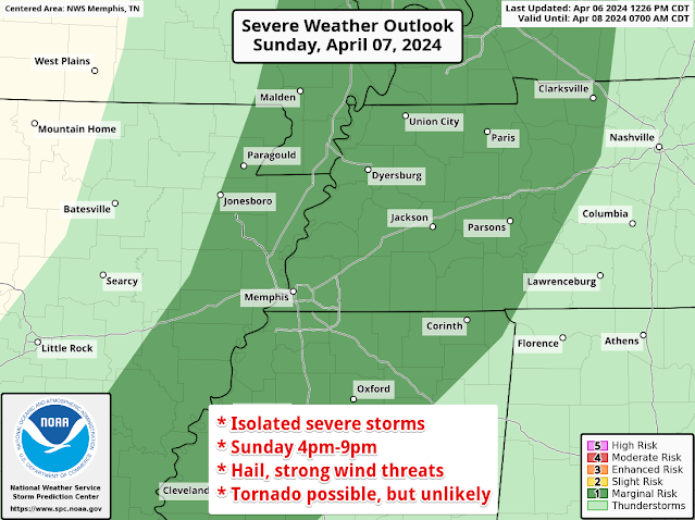
A weak front moves into the area Sunday night. Ahead of it, south wind will become gusty, reaching 30 mph in the afternoon, and temperatures will reach the mid 70s as clouds also increase. We'll see scattered showers and a few t'storms, mainly in the afternoon and evening. A couple of these storms could get a little feisty from late afternoon until just after sunset, so the Storm Prediction Center has outlooked the area for a Marginal Risk of a severe storm. That's just a level 1 on the 5-point scale, so no widespread problems are affected, but isolated storms could have some hail or gusty wind, and a brief tornado can't be completely ruled out due to the wind shear in place. All of this comes to an end by 9-10pm.
Eclipse Day!
We've been watching this closely every day for the past week and are finally getting into a window of time where our high-resolution models are seeing the early afternoon hours Monday, offering more guidance on the forecast. I am fairly confident that morning low clouds will occur as the Sunday night front washes out over us. I'm also confident that conditions will remain dry through the afternoon.
 |
| Forecast cloud cover at the time of the eclipse on Monday afternoon, courtesy NWS-Memphis |
We'll start to see those clouds to our south pull further north as the afternoon and evening progress, both here and in Arkansas, as a very wet pattern starts to set up. Monday night could see the first of several rounds of showers and thunderstorms as a warm front moves north. A few of those storms could contain marginally severe hail and some wind gusts overnight.
Tuesday-Thursday
We're expecting what may be more wet hours than dry for a couple of days mid-week, with bouts of thunderstorms embedded in rain. Some of those could be strong, especially Wednesday to Wednesday night, though more likely in north MS and southern AR than west TN. With repeated rounds of rainfall, multiple inches of pollen-cleansing rain are in order! We'll hope the severe stuff stays away, but you'll want to stay in touch for further updates as overnight storms are a possibility.
By Thursday, low pressure responsible for all the rain will be moving through the Mid-South, tapering the stormy weather off to showers. By Friday, rain should be done and the drying process can commence as we head into the middle weekend of April. Overall, temperatures throughout the mid- to late-week period will be mild as high temperatures will be within a few degrees of 70 and lows will fall only into the 50s and 60s.
Here's to amazing eclipse viewing conditions and sturdy umbrellas next week!
Erik Proseus
MWN Meteorologist
----
Follow MWN on Facebook and Twitter for routine updates and the latest info!
Complete MWN Forecast: MemphisWeather.net on the mobile web or via the MWN mobile app
Download our iPhone or Android apps, featuring StormWatch+ severe weather alerts!
MWN Meteorologist
----
Follow MWN on Facebook and Twitter for routine updates and the latest info!
Complete MWN Forecast: MemphisWeather.net on the mobile web or via the MWN mobile app
Download our iPhone or Android apps, featuring StormWatch+ severe weather alerts!
 |  |
| MWN is a NOAA Weather Ready Nation Ambassador | Meteorologist Erik Proseus is an NWA Digital Seal Holder |

.gif)
.gif)


No comments:
Post a Comment