A wonderful day is on tap today with sunny skies and warm temperatures. However, southerly winds look to make their return by tomorrow, which means that chances for thunderstorms return as well. Lets take a look at the details.
 |
| NAM model simulated radar at 7pm Thursday. In this scenario, an initial line of storms during the afternoon in AR has weakened as it moves across the river while another line is approaching the metro along the cold front. This is a MODEL interpretation, not an actual forecast. |
A simulated radar image from the 4-km NAM shows scattered showers and thunderstorms around the Memphis area by 7 PM Thursday with a line along a cold front to the west that would move through during the evening. I mention that southerly winds were the cause of this, lets take a look at the bigger picture.
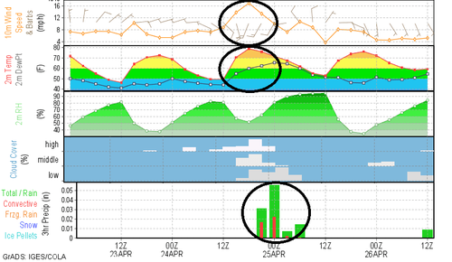 |
| NAM meteogram, displaying wind speed/direction, near surface temperatures, dew points, relative humidity, cloud cover, and forecast 3hr precipitation amounts |
The NAM meteogram above shows exactly what I mean. Winds have shifted overnight to become easterly today. By tomorrow we see a wind shift to the south (top circled area) which results in increased temperatures, and perhaps more importantly dew points (measure of moisture), both shown in the second row. Both of these increase as a result of the warmer, moist air being transported from the Gulf of Mexico northward. This increase in heat will pave the way for scattered thunderstorms as an upper level disturbance approaches the area. The result is scattered showers and thunderstorms from late Thursday afternoon into the evening (forecast precipitation amounts in the bottom row).
 |
| Probability of severe weather within 25 miles of a point on Thursday PM, per SPC. |
Due to the timing of the storms at peak heating on Thursday, a Slight Risk of severe weather exists across east AR, far western TN and northwest MS into northern LA. The probability of severe weather within 25 miles of the metro is 15% and the primary severe weather threat is strong to damaging wind and hail to 1". This severe weather probability is not high, but it is worth considering if you have outdoor plans between about 4-10pm Thursday. The chance of rain is about 50/50 currently, but any storms that form could be strong.
Looking ahead...
 |
| GFS mid-level atmospheric height anomalies at mid-day Monday, showing a strong disturbance in the Plains moving east (greens/blues). A favorable area for severe weather is ahead of this disturbance. |
...to a potentially more significant threat, we will see a rather significant trough to the west of the Mid-South by Monday. These large upper-level disturbances can create particularly nasty weather to their east. As a result, we are monitoring the potential for strong to severe storms heading into Monday. Right now we are anticipating storms starting Sunday (maybe late in the day) and continuing into Monday. We'll have updated information in future blogs and on our social media channels, but as of now all types of severe weather are possible, including tornadoes.
 |
| SPC is monitoring the area in green for severe weather on Monday. |
Make sure you have your severe weather plans in place as we get closer to these potential severe weather events and the climatological peak of severe weather season. We'll keep you updated on each event and provide complete coverage during the events on social media.
--William Churchill, MWN Social Media Intern
--Erik Proseus, MWN Meteorologist
----
Follow MWN on
Facebook,
Twitter, and
Google+
Visit
MemphisWeather.net on the web or
m.memphisweather.net on your mobile phone.
Download our
iPhone or Android apps, featuring
StormWatch+ severe weather alerts!

No comments:
Post a Comment