
Outflow Boundary 101
Within the towering clouds that make up a thunderstorm are updrafts and downdrafts - basically, vertical rivers of air that carry precipitation high into the cloud and then unload it on those below. In the formative stages of a thunderstorm, the updraft dominates as the clouds grow. In a mature storm, updrafts and downdrafts are relatively equally balanced. As the downdraft begins to dominate, the storm falls apart and "rains itself out." The diagram below demonstrates this well, with the yellow arrows showing the direction of the air flow.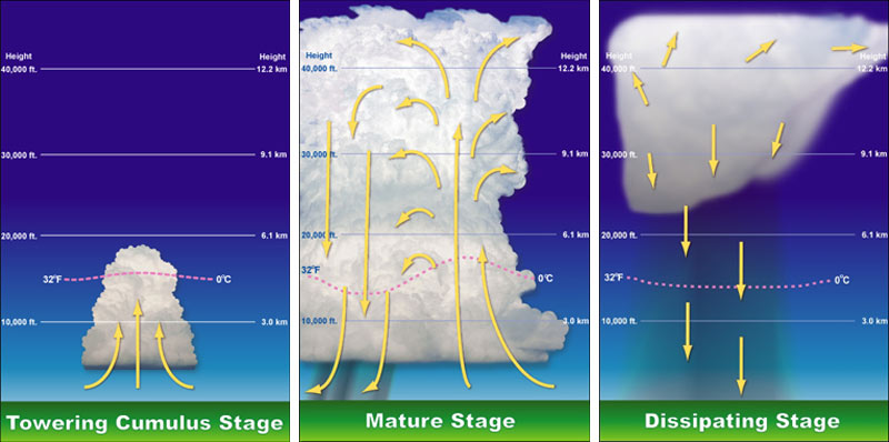 |
| The stages of a thunderstorm, showing the role of downdrafts and updrafts |
The downdrafts from mature and dissipating storms rush towards the ground and, if not caught by an updraft forcing the air back up, come crashing to the ground, sometimes with great force. When the air hits the ground, it obviously does not penetrate the earth, it spreads out, typically in all directions. The rush of thunderstorm air outwards from the downdraft is called an outflow boundary, or gust front. (Side note: another name for strong downdrafts that create very gusty wind at the ground are microbursts. They are the cause of much of the straight-line wind damage that is caused by summer storms, including the trees and power poles damaged this afternoon in Cordova.)
Because the air that originated from the thunderstorm and is rushing out behind the outflow is cooler than the air it is displacing, a mini cold front is, in essence, created along that boundary or gust front. Cold fronts that encounter warm humid air, untouched by a thunderstorm outflow, can cause new storms to form, just as the storms they originated from are dissipating.
This was very evident late this afternoon as shown in the radar loop below. The outflow boundaries are the thin blue lines expanding from the storms (air rushing away from the storms that produced the downdrafts). As they encounter virgin air that was in the 80s, new storms form on the boundaries. Watch the loop a few times and see for yourself!
Outflow Boundary 102
So why do the outflow boundaries appear as thin blue lines on radar? First, the blue color is simply one of the lowest values on the radar scale used in this loop. So how are they even detected? Remember that radar detects not only precipitation, but anything in the air, even very small particles that we may not see with the naked eye, that reflects radar energy back to the radar dish. In this case, the gusty wind is picking up dust, dirt, and other small objects like bugs (!). Those objects are detected by the radar just as raindrops are. Because they "float along" on the leading edge of the outflow boundary, they make it easy to detect exactly where the boundary is without looking at the radar velocity (wind) product to see which way the wind is actually blowing!Another detailed description of outflow boundaries/gust fronts, with radar imagery and photographs to illustrate, can be found in this previous post from the MWN Blog. To view the loop above in a separate window, click here.
----
Follow MWN on Facebook, Twitter, and Google+ Visit MemphisWeather.net on the web or m.memphisweather.net on your mobile phone. Download our iPhone or Android apps, featuring a fresh new interface and StormWatch+ severe weather alerts!
No comments:
Post a Comment