October Climate Stats
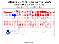
 While the U.S. experienced its wettest, and third coolest, October in recorded history, that didn't bear out across the rest of the globe. NCDC indicates, and Dr. Jeff Masters of Weather Underground reports, that last month was the 6th warmest October on record globally. In the U.S., temperatures averaged 4.0F below normal, while precipitation was almost double the typical October average. It appears from the graphic above that outside of the continental U.S., northern Europe was the only other region where temps averaged below normal. In addition, U.S. drought and fire activity both decreased in October.
El Nino Strengthens
 According to the Climate Prediction Center's (CPC) weekly El Nino report issued this morning, El Nino conditions have strengthened across the central and eastern Pacific in the past month, with sea surface temperatures now averaging 1.0-2.0 degrees above normal. In fact, the most watched region of the Pacific (dubbed "El Nino 3.4") has now crossed a threshold that allows this El Nino event to be classified a "strong" event. Model forecasts call for moderate to strong El Nino conditions to continue through the 2009-2010 Northern Hemisphere winter. Three-month forecasts for the Mid-South reflect semi-typical El Nino considerations, including slightly below normal temperatures and below normal precipitation. More on the current El Nino conditions can be found here.
Another Winter Forecast
My blogosphere friend Paul Yeager of CloudyandCool.com wrote yesterday about a computer model called the NCEP coupled forecast system (CFS) that has advantages over typical day-to-day models in forecasting long-range (read Paul's blog for a great explanation). In the FWIW category, the CFS output agrees with the CPC and most other winter forecasts that have taken into consideration the effects of El Nino and forecasted cool and dry winter months for the Mid-South. For a look at U.S. temperature forecast maps from the CFS, click here, and for precipitation, click here.
Doppler Ducks
 Ryan Vaughan with KAIT-TV in Jonesboro woke up Saturday morning to reports of large flocks of waterfowl (likely geese and some ducks) flying south over northeast AR. As he checked NWS Doppler Radar, he noticed what appeared to be light rain showers headed south over the area (while other returns were moving northeast through north MS). Putting two and two together, it was determined that the migratory birds were showing up on radar! (Read more on Ryan's blog, including a radar loop of the occurrence.)
While a very cool thing to witness, birds on radar is certainly not unprecedented (see my previous blog, "The Birds"). In fact, during certain times of year, at sunrise, "expanding donuts" of radar echoes appear near Reelfoot Lake and other areas around the region known to be excellent sleeping spots for our feathered friends. As the waterfowl take off in all directions, they show up as an ever-expanding ring of echoes.
So hunters, not only will checking the early morning forecast on MemphisWeather.net be helpful in determining the weather conditions for your stakeout, but accessing Doppler radar on MWN Mobile might net you a heads-up to an approaching flock!
----
Become a fan of MemphisWeather.net on Facebook and follow MWN on Twitter!

No comments:
Post a Comment