Saturday, October 8, 2022

The good and bad of prolonged dryness, and when rain will fall again

The big weather story for the Mid-South is the arrival of beautiful fall weather that has stuck around for a few weeks now. While fortunate in that we can enjoy some terrific weather and not worry about rain-out's, the flip side is that drought is once again taking hold on the region, affecting everything from allergies due to dust and other foreign debris in the air to Mississippi River traffic that is severely limited by low water.

The Drought Monitor for this past week shows expanding dry conditions across the region, including Moderate Drought in the southern and western metro. (UNL Drought Monitor)


Precipitation the past 30 days

The last 30 days or so has featured one "round" of precipitation - scattered storms on Saturday evening, September 24 that brought very heavy rain to some and little to none for others. A look at the 30 day rainfall anomalies (below) shows that much of the region, especially west of the river, has received less than 25% of normal precipitation in the past month - in fact much of Arkansas has not had a drop of rain.
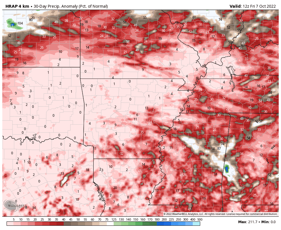
Rainfall anomalies (as a percentage of normal) for the past 30 days are significantly below normal, in fact near 0% for much of AR into OK and TX and well below 50% for our area. (WeatherBell)

Effects on the Mississippi River

The bigger picture is that the lack of precipitation throughout the Mississippi and Missouri River Valleys has resulted in water levels on the river that are in the top 10 lowest on record. Barge traffic has been reduced to a trickle through our area, which is starting to affect supply chain, particularly for agricultural goods that flow south on the river from harvested land in the Midwest. The lowest reading of late was -.8.2 feet on October 3, which ranks 7th lowest on record. While up just a bit, the river is forecast to get that low again within some much-needed rainfall, especially up-river.

The hydrograph for the Mississippi River at Memphis points to water levels well below the "low stage" of 5 feet, running between 5-8 feet below zero so far this month. Projections are for water levels to remain historically low well into October. (NWS/AHPS)

Looking ahead

In the wake of another dry cold front on Thursday evening, we are once again enjoying an amazing weather weekend with sunshine, highs in the 70s, and crisp mornings. Today (Saturday) will likely be the coolest day in Memphis since April, and tonight, all Mid-South residents will see temperatures drop into the 40s, while some frost will be possible in northern reaches of the Mid-South. 

The week ahead features a warming trend ahead of another cold front that arrives early Thursday. We'll be back in the low 80s Monday, then the mid 80s for the mid-week period, though low dewpoints will allow for mornings to still be pleasantly cool for a few days. By Wednesday, clouds will increase, as will humidity, setting the stage for a decent chance of precipitation for many of us. The most likely timeframe for rainfall will be Wednesday night (satisfying many of you who would like rain, but not during the day so you can enjoy the fall weather!). A few thunderstorms cannot be ruled out as dewpoints climb into the mid 60s. While projected rainfall totals aren't overly impressive, anything will help at this point! 

Forecast precipitation from the National Weather Service through mid-day Thursday.  About one-half inch is forecast in the metro. Here's hoping we all get that much, or more! (WeatherBell)

Behind the front, sunshine returns Thursday and continues into next weekend, with another shot of cool weather as well. Highs will be back in the 70s through next weekend with morning lows in the 50s. 


There are signs of an even bigger cool down about 10 days out as we get deep into mid-October, but we'll see how that plays out. In the meantime, we've got one decent chance of rain late Wednesday into early Thursday to plan around, otherwise Fall Break looks pretty good!

Erik Proseus
MWN Meteorologist

----
Follow MWN on Facebook and Twitter for routine updates and the latest info!
Complete MWN Forecast: MemphisWeather.net on the mobile web or via the MWN mobile app
Download our iPhone or Android apps, featuring StormWatch+ severe weather alerts!
MWN is a NOAA Weather Ready Nation Ambassador Meteorologist Erik Proseus is an NWA Digital Seal Holder

Wednesday, October 5, 2022

September 2022 Climate Report for Memphis, TN

September Climate Recap

Temperatures in September started above normal for the first week of the month as highs routinely reached the 90s, however, a cold front brought the mercury back down to near average into the second week of the month. Another warming trend took hold as strong high pressure built over the middle of the country starting in the middle of the month. Highs jumped back into the 90s mid-month, then climbed even higher, reaching the century mark on the 20th, then 102 degrees the next day, setting a record for the latest day to reach 100 degrees in 150 years of records. A cold front knocked down temperatures heading towards the end of the month, then the first major autumn front arrived on the 25th with lows dropping almost to 50 in the city and widespread 40s in rural areas the last couple of mornings of September.

Temperature anomalies for the month of August show near average temperatures across our region. Memphis ended up just under 2 degrees above normal by statistical methods. (PRISM temperature dta via WeatherModels)

Precipitation for the month was below average, though the month started off near normal with a few rain events during the first third of the month. After that, sprawling hot high pressure squashed rain chances for about two weeks. A cold front on the 24th brought scattered strong thunderstorms and heavy rain to parts of the metro, then the month ended with a week of cool and dry weather. Some minor wind damage occurred in Tipton County (Covington) with the storms on the 24th and a few Severe Thunderstorm Warnings were issued that evening. The MWN weather station in Bartlett ended the month with just over an inch of rain, while a little over two inches fell at Memphis International. The relief from drought conditions in August was short-lived as drought started to creep back into the metro by the end of September.

The Drought Monitor shows what happens when a tenuous situation meets a dry month - some form of drought encompassed much of the Mid-South by the end of September, after recovering somewhat in August. (U.S. Drought Monitor)


Another sign of a lack of precipitation, particularly upstream from Memphis, is a negative value on the river gauge on the Mississippi River at Memphis. At the end of September, river levels were hovering around -7.0 feet, one of the "top 10" lowest stages on record. (National Weather Service)


Memphis International Airport, Memphis, TN

Temperature 
Average temperature: 77.7 degrees (1.7 degrees above average) 
Average high temperature: 88.8 degrees (2.8 degrees above average) 
Average low temperature: 66.7 degrees (0.8 degrees above average) 
Warmest temperature: 102 degrees (21st) 
Coolest temperature: 51 degrees (29th, 30th) 
Heating Degrees Days: 3 (4 below average)
Cooling Degree Days: 394 (59 above average) 
Records set or tied: Record high temperature tied on the 20th (100 degrees). Record high temperature set on the 21st (102 degrees), which also set the record for the latest occurrence of 100 degrees.
Comments: 17 days saw high temperatures meet or exceed 90 degrees, which is 6.8 above normal. Two days also reached 100 degrees, including the latest occurrence of a 100-degree day on record on the 21st. On average, a 100-degree day occurs in September every 14 years. In the last 14 years, it has occurred four times.

Precipitation 
Monthly total: 2.24" (0.79" below average) 
Days with measurable precipitation: 5 (2.1 days below average) 
Wettest 24-hour period: 1.37" (3rd-4th) 
Snowfall: 0.0"
Records set or tied: None
Comments: None 

Miscellaneous 
Peak wind: Southwest/31 mph (26th) 
Average wind: 6.1 mph 
Average relative humidity: 59%
Average sky cover: 34%

 Click here for a daily statistical recap for Memphis International Airport.
 

Cirrus Weather Solutions / MemphisWeather.net, Bartlett, TN

Temperature 
Average temperature: 72.6 degrees 
Average high temperature: 86.4 degrees 
Average low temperature: 61.4 degrees 
Warmest temperature: 99.4 degrees (21st) 
Coolest temperature: 46.0 degrees (30th) 
Comments: None 

Precipitation 
Monthly total: 1.37" (automated rain gauge), 1.40" (manual CoCoRaHS rain gauge) 
Days with measurable precipitation: 2
Wettest date: 0.97" (3rd) (via automated gauge) 
Snowfall: 0.0"
Comments: None

Miscellaneous 
Peak wind: Northeast/19 mph (28th)
Average relative humidity: 72% 
Average barometric pressure: 30.03 in. Hg
Comments: None

Click here for a daily statistical recap for Bartlett, TN.
 

MWN Forecast Accuracy

MWN average temperature error: 1.83 degrees 
MWN forecast temperatures within 2 degrees of actual: 74% 
MWN average dewpoint error: 1.60 degrees 
MWN forecast dewpoints within 2 degrees of actual: 79% 

MWN's forecasts extend out five periods (2.5 days, or roughly 60 hours). Historical accuracy statistics can be found here.

--- 
Follow MWN on Facebook and Twitter for routine updates and the latest info! 
Complete MWN Forecast: MemphisWeather.net on the mobile web or via the MWN mobile app 
Download our iPhone or Android apps, featuring StormWatch+ severe weather alerts!
MWN is a NOAA Weather Ready Nation Ambassador Meteorologist Erik Proseus is an NWA Digital Seal Holder