
The bulk of the precipitation is now exiting the metro, leaving behind only a few light showers. Mainly dry conditions for the next couple of hours will help the smaller streams and tributaries absorb remaining runoff and push it into the larger creeks and rivers, which will continue to remain high (likely near or above flood stage) throughout the afternoon and evening hours. Use extra caution on roads near the larger tributaries, such as the Wolf River, Nonconnah Creek, and Loosahatchie River.
As for the rest of the afternoon, unfortunately some peeks of sunshine could mean scattered showers and t'storms redevelop. Whether they affect the metro is TBD, however we're keeping a chance of rain in the forecast into early evening and remain hopeful that it'll be gone for most evening activities. (It's worth noting that the latest high-resolution model data keeps rain chances around until 8-9pm.)
After this evening, we expect dry and hot conditions until Wednesday when a weak cold front arrives. The abundant rain may temper the expected mid 90s highs on Monday and Tuesday a bit as saturated ground is harder to heat than dry ground. That could be offset by higher humidity values though as the water evaporated from the ground. One more "worth mentioning" is that one model is trying to form more precip over us in the early morning hours Monday. Not sure that will happen, but I'll throw it out there!
As of noon, we have had the 7th wettest day in recorded Memphis history at 5.87" of rain and are now the second wettest June on record at 13.40" for the month. Unbelievable.
ORIGINAL POST WITH STATS UPDATED AS OF NOON:
Rain and thunderstorms began around 2am this morning and have continued, mainly in a heavy manner, ever since. I posted this at 8:30am and last updated at noon. Earlier this morning, the National Weather Service pulled the trigger on a very rare "Flash Flood Emergency" for Memphis and Shelby County, and DeSoto and northern Tunica Co. in MS and has since extended it until 4:30pm this afternoon. Flash Flood Warnings are also in effect for Crittenden Co in AR, Fayette Co in TN, and northern Marshall Co in MS.
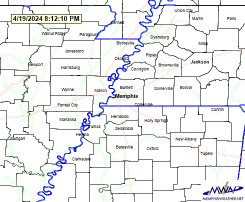 |
| Flash Flood Warnings are in maroon hatch, river Flood Warnings in green outline, and Flash Flood Watches in green shading. A Flash Flood Emergency is in effect for Memphis and Shelby County |
Records are seemingly falling as fast as the rain does. As of noon, the Memphis International Airport has received 5.87" of rain since midnight. The daily rainfall record has been shattered and we're now into the top 10 wettest days on record at #7. In addition, the month of June has now seen 13.40" of rain, becoming the second wettest June on record. The top spot belongs to June 1877, which saw 18.16" of rain.
 |
| Storm total rainfall estimates from the NWS Doppler show 5-8" across portions of the metro since yesterday. |
 |
| Top 10 wettest days in Memphis (through 11:30am today) |
 |
| Top 10 wettest Junes in Memphis (through 11:30am today) |
Beyond the stats, the situation is becoming life-threatening. Already reports are coming in of stranded motorists and water rescues by the Memphis Fire Department. Local rivers and creeks are rising above flood stage due to massive runoff, which will cause further backup of water on streets and low lying areas as the water has no place to go.
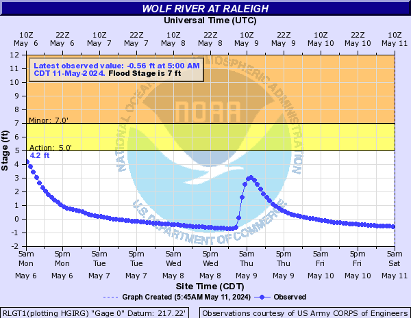 |
| The latest hydrograph (plotted river stage) for the Wolf River in Raleigh (Austin Peay). |
When will we see a break? Well, for good, by early evening when the entire system exits. However, it appears areas north of the TN/MS line still have a couple of hours of rain and thunder to deal with, though late morning. Then scattered "summertime" thunderstorms will begin to pop after lunch time and will affect mainly north MS and east AR, but we could also see a few southwest TN. All of the activity looks to be done by about 6pm, I hope! That's the best educated guess I have right now.
In the meantime, if you don't have to go out this morning, don't. If you do, use EXTREME caution, plan your route on roads that you know are not prone to flooding or that cross creeks that flood, and if you do encounter water across the road...

... it could save your life!
Erik Proseus
MWN Meteorologist
----
Follow MWN on Facebook, Twitter, and Google+
Visit MemphisWeather.net on the web or m.memphisweather.net on your mobile phone.
Download our iPhone or Android apps, featuring StormWatch+ severe weather alerts!
No comments:
Post a Comment