
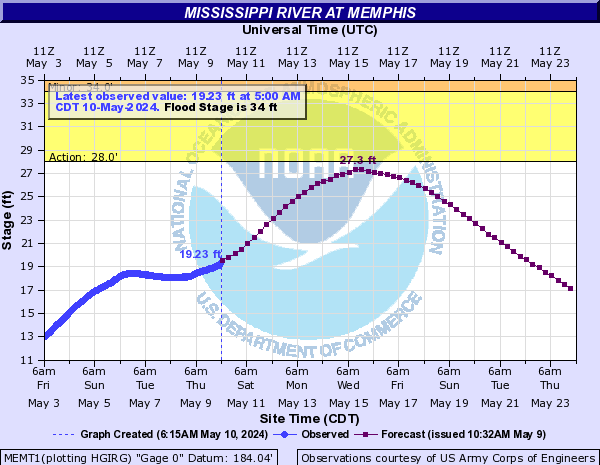
PUBLIC INFORMATION STATEMENTAs mentioned in the previous post, there is nothing to indicate that we re going to experience anything close to the historic levels we saw in 2011. In fact, the crest of 32' on May 1 is expected to be followed by falling water, which will be well within the natural boundaries of the river about 10 days later. However, if you head down to the river early next week, you'll notice that most land on the west side of the river will be covered by water, as far west as the West Memphis levees. The latest hydrograph for the Memphis river gauge is below.
NATIONAL WEATHER SERVICE MEMPHIS TN
1257 PM CST THU APR 25 2013
...WATER LEVEL OUTLOOK FOR SHELBY COUNTY...
WATER LEVELS ALONG THE MISSISSIPPI RIVER ARE FORECAST TO CONTINUE RISE OVER THE NEXT FEW DAYS. THE MISSISSIPPI RIVER AT MEMPHIS IS FORECAST TO REACH 32 FEET ON WEDNESDAY MAY 1ST....WHICH IS BELOW FLOOD STAGE OF 34 FEET.
NEVERTHELESS...FORECAST MISSISSIPPI RIVER WATER LEVELS WILL CAUSE RISES ON THE TRIBUTARIES IN SHELBY COUNTY...NOTABLY THE LOOSAHATCHIE RIVER...WOLF RIVER AND NONCONNAH CREEK. ANY TRIBUTARY RISES WILL BE NOTED IN LOCATIONS CLOSEST TO THE MISSISSIPPI RIVER AND WILL CAUSE WATER TO FLOW INTO TYPICAL LOW-LYING AREAS ALONG THESE TRIBUTARIES.
THIS WEEKEND RAINFALL OF 1 TO 2 INCHES IS EXPECTED ACROSS THE MEMPHIS METRO AREA. THIS MAY CAUSE ADDITIONAL RISES ON THE TRIBUTARIES...HOWEVER FLOODING IS NOT EXPECTED IN BUSINESSES OR HOMES.
THE NATIONAL WEATHER SERVICE AND SHELBY COUNTY OFFICE OF PREPAREDNESS IS CAUTIONING THOSE WITH INTERESTS...OFTEN RECREATIONAL...IN THESE LOW LYING AREAS TO PAY ATTENTION TO RIVER LEVELS. IN ADDITION... STAY TUNED TO THE LATEST FORECAST IN CASE MORE RAIN THAN FORECAST DOES FALL CAUSING ADDITIONAL RIVER LEVELS TO FURTHER RISE.
----
Follow MWN on Facebook, Twitter, and Google+
Visit MemphisWeather.net on the web or m.memphisweather.net on your mobile phone.
Download our iPhone or Android apps, featuring a fresh new interface and StormWatch+ severe weather alerts!
No comments:
Post a Comment