
 |
| Hurricane Isabel, 2003 |
As it turned out, 2010 produced a very active season that was unusual in the lack of U.S. landfalls given the number of storms. There were 19 named storms, 12 hurricanes, and 5 major hurricances (Category 3 or higher). Amazingly, with 12 hurricanes, there were no U.S. hurricance landfalls and only one Tropical Storm - Bonnie, which grazed south FL and fell apart as soon as it hit southeast LA. Another storm, T.S. Hermine, made landfall just south of the U.S.-Mexico border, technically in Mexico. Though the U.S. was spared, there were two landfalling hurricanes in Canada - Earl in southeast Nova Scotia and Igor, near St. John's, Newfoundland. Both reached Major Hurricane status over the Gulf Stream.
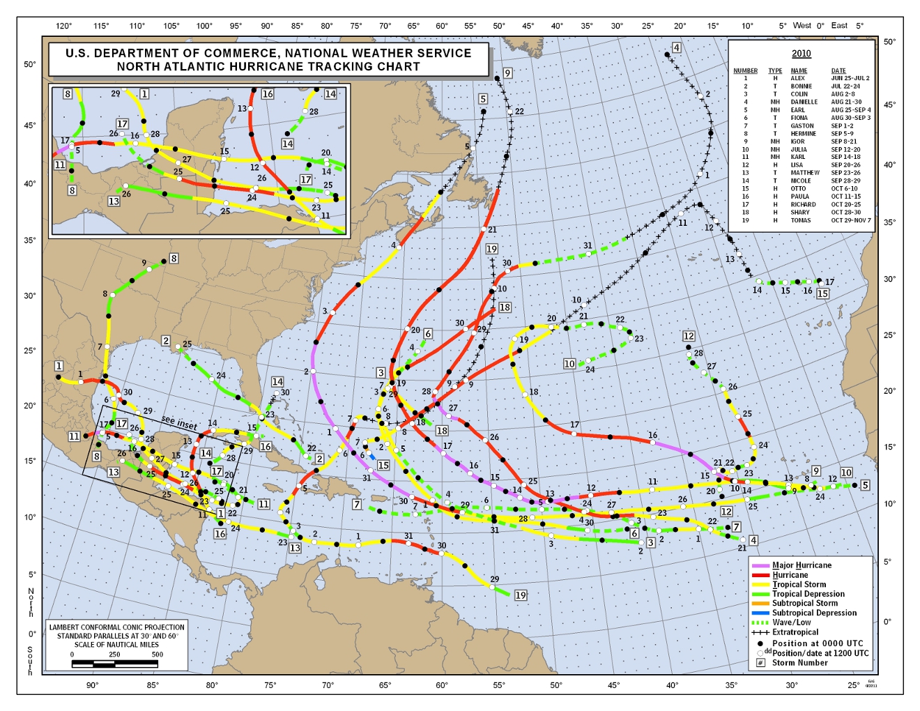 |
| Tracks of all named 2010 Atlantic tropical systems (click for larger image) |
So, onto this year! NOAA indicates that the climate factors that will affect this year's Atlantic hurricane season include the fact that we are in a continuing high activity era, which has been ongoing since 1995 and is multi-decadal, warm sea surface temperatures about 2° F above the long-term average in favored storm development regions (a phenomena referred to as the Atlantic Multidecadal Oscillation, or AMO), and, though La Nina is dissipating, it's impacts such as reduced wind shear over the Atlantic will continue into the hurricane season. Wind shear is a hurricane killer - less wind shear allows storms to develop and maintain strength. Tropical Atlantic forecasts issued for 2011 are listed below.
NOAA
Named storms: 12-18
Hurricanes: 6-10
Major hurricanes: 3-6
Colorado State University
Named storms: 16
Hurricanes: 9
Major hurricanes: 5
72% chance of a U.S. landfall
Accuweather
Named storms: 15
Hurricanes: 8
Major hurricanes: 3
Last year, I closed my hurricane forecast blog with this statement, and it is appropriate again this year:
"As hurricane season begins, it is wise for those that could potentially be in the path of one of these storms to make all necessary preparations and pay close attention to forecasts and watches/warnings as they are issued by the National Hurricane Center. For those living in the Mid-South, MemphisWeather.net's tropical page will have the latest storm tracks and bulletins. Be mindful that, while the threat is not nearly as great here [in the Mid-South], remnants of tropical systems can bring widespread flooding rains, tropical storm force wind, and/or severe weather to this region of the country."
Stay tuned... Hurricane season begins on Wednesday!
----
Stay up to date on the latest weather conditions and forecast by checking out MemphisWeather.net on Facebook and Twitter and our new iPhone and Android apps!
No comments:
Post a Comment