 |
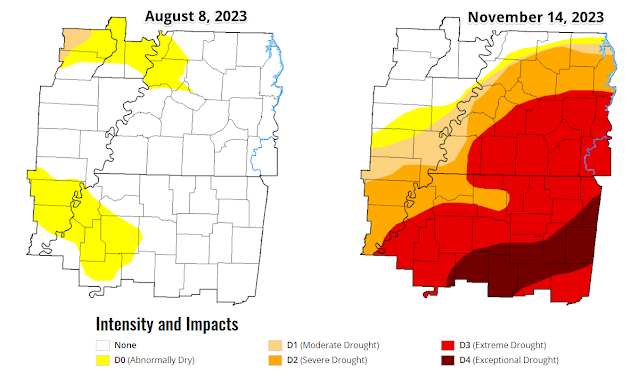
| A comparison of the Drought Index for the Mid-South from early August to this week tells the story about the lack of beneficial rainfall. (UNL Drought Monitor) |
 |
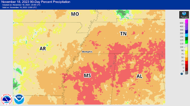
| The rainfall deficit in the past 90 days is shown above. For the Memphis area, we only received about 25-50% of normal rainfall in this period. Conditions are worse to our south and east. (NOAA/NWS) |
We'll end the weekend with similar conditions to how it started though, as Sunday looks very pleasant with plenty of sunshine, dry air, and highs in the mid 60s. A light wind shifting from the northeast to the east is a sign of what's to come though, as low pressure moves into the Plains, turning those winds around to the southeast Sunday night when a smattering of light showers are likely to start moistening the atmosphere and "priming the pump" for Monday.
By Monday, southeast wind will pick up and rain chances increase as the day goes on, particularly by mid-afternoon, as low pressure moves into AR. Highs will again be in the mid 60s, but dewpoints surge from the 30s Sunday to the 50s Monday. By late afternoon, some showers could be heavy. As of Saturday evening, it appears that low pressure system will pass by just to the north of the metro on Monday night, bringing a round of thunderstorms during the evening hours.
To our south, where instability will be maximized, some storms could be strong to severe across southern AR into MS and eventually (later in the night) western AL. While thunder will be possible, perhaps likely, in the metro, the severe weather threat should stay just to our south, though a storm could produce strong wind gusts locally.
 |
| The severe weather threat for Monday evening is mostly to our south, though a couple of strong storms are possible in north MS, per the Storm Prediction Center outlook posted Saturday. (SPC) |
In addition, rain will be heavy, particularly from around rush hour through the evening, tapering off as a cold front moves through around midnight or so. Up to 2" of rain is possible for this event, though most places will likely remain under that, but receive at least an inch. This will certainly help with the drought, keeping it from getting any worse if nothing else.
 |
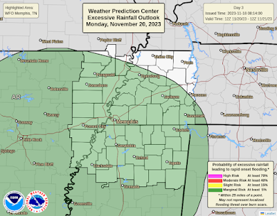
| There is a Marginal Risk of excessive rainfall that could result in flooding for the entire area on Monday. (Weather Prediction Center) |
Behind this system, cooler and drier weather sets in once again for the rest of Thanksgiving week. A few lingering showers are possible Tuesday morning with temperatures that pretty much sit in the 50s all day on north wind. Skies clear for mid-week and conditions remain dry through at least Friday. Look for morning lows in the 30s to near 40, including for Thanksgiving Day, and highs generally in the mid 50s under fair skies. Sounds like a good time to take some time off work, eat too much, and maybe get the Christmas decorations out!
Erik Proseus
MWN Meteorologist
----
Follow MWN on Facebook and Twitter for routine updates and the latest info!
Complete MWN Forecast: MemphisWeather.net on the mobile web or via the MWN mobile app
Download our iPhone or Android apps, featuring StormWatch+ severe weather alerts!
Erik Proseus
MWN Meteorologist
----
Follow MWN on Facebook and Twitter for routine updates and the latest info!
Complete MWN Forecast: MemphisWeather.net on the mobile web or via the MWN mobile app
Download our iPhone or Android apps, featuring StormWatch+ severe weather alerts!
 |  |
| MWN is a NOAA Weather Ready Nation Ambassador | Meteorologist Erik Proseus is an NWA Digital Seal Holder |


No comments:
Post a Comment