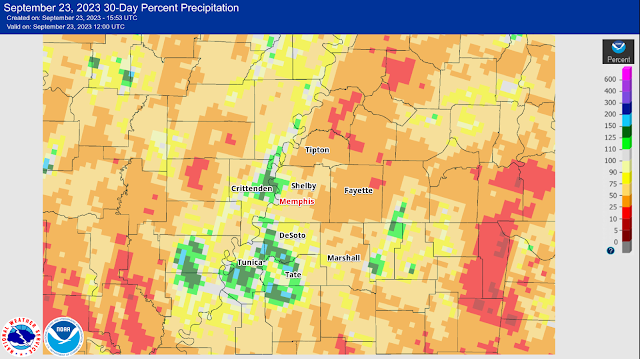
A pretty wild and stormy summer has transitioned to much drier conditions of late, with temperatures generally near to slightly below average over the past month or so. Comparing the departure from normal precipitation for the past 90 days (in the first image below) to the past 30 days (second image) really shows how the northern metro received plentiful precipitation earlier this summer, but more recently, most of the area has dried up.
We also see drought conditions expanding in north Mississippi in the past 30 days, since that area started the summer with much less rainfall than west TN.
.png) |
| Drought Index for the Mid-South as of this week. The Mississippi Delta is running well below normal for precipitation this summer. (U.S. Drought Monitor) |
As summer officially turns to fall today (at 1:50am this morning), we're starting pumpkin spice season off with above average temperatures. Afternoon temperatures will flirt with the 90 degree mark, which is not completely unusual since our typical last 90 degree day is September 19. (And recall clast year, when mid-September featured multiple 100 degree days!) But it doesn't FEEL much like fall out there! Thank goodness for humidity levels that are early-autumn-like.
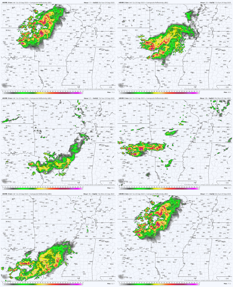
A frontal system will approach the area on Sunday, bringing more clouds which will temper the warmth. It will also introduce scattered shower and thunderstorm chances, especially Sunday afternoon and night into Monday morning. However, the HRRR model (below) is more bullish on storms in Arkansas than areas east of the Mississippi River, thanks to high pressure to our east causing precipitation to fall apart as it approaches.
Once we get past Monday, another dry spell sets up for the rest of the week it appears, with temperatures just slightly above normal. It'll be a rinse-and-repeat pattern with partly cloudy to mostly sunny skies, high temperatures in the mid 80s and morning lows in the mid 60s. Normal highs this time of year run about 82-84 degrees.
If you are waiting for visible signs of fall (not Starbucks advertising signs for PSL's!), fall colors are still about a month off in the Mid-South. Any leaves changing color at this point are more likely due to trauma from lack of precipitation than true fall color setting in!
Erik Proseus
MWN Meteorologist----
Follow MWN on Facebook and Twitter for routine updates and the latest info!
Complete MWN Forecast: MemphisWeather.net on the mobile web or via the MWN mobile app
Download our iPhone or Android apps, featuring StormWatch+ severe weather alerts!
 |  |
| MWN is a NOAA Weather Ready Nation Ambassador | Meteorologist Erik Proseus is an NWA Digital Seal Holder |


.gif)

.gif)
No comments:
Post a Comment