Showing posts with label outflow boundary. Show all posts

Monday, September 1, 2014

Gravity waves from Missouri storms result in Labor Day showers in the metro

Pop-up showers around mid-day today were a bit of a surprise, as they were not indicated by computer models early this morning and, according to our forecasts over the weekend, Labor Day appeared to be a dry day. However, an event currently not easily "forecast-able" by the models was the cause for these showers - a set of gravity waves!

Sometimes these atmospheric waves can be detected in radar imagery, but if conditions are just right, they are more easily detected using visible satellite imagery, as was the case this morning. The image below, taken at 8:30am, shows an arc of clouds from OK through AR, into western TN and KY. This arc is the outflow boundary from the MO storms. However, the outflow was accompanied by a series of gravity waves as well, most clearly visible in OK in the circled region (the technical term for this phenomena is an undular bore). Click here for an animation of this satellite imagery clearly showing the waves propagating away from the storms between 7-10am CDT (animation download is large and recommended for high-speed internet users). Also, the waves can be faintly seen in this (large) radar loop from about 6am-10am this morning around Oklahoma City, Little Rock, and over east AR from the Memphis radar.

An outflow boundary from decaying thunderstorms in KS/MO moved across OK, AR, TN, and KY this morning as shown in the satellite image taken at 8:30am. Gravity waves were also present behind this outflow, best seen in the circled area in OK. Click here for a satellite loop clearly showing the waves propagating away from the storm complex (Warning: VERY large animation - best with high-speed connections).

So what conditions were responsible for the waves that occurred this morning and why did showers result in the Mid-South?

Just as when a pebble is thrown into a calm body of water, waves in the atmosphere spread out from a large disturbance such as a thunderstorm complex. In meteorology, these waves are called "gravity waves" and they form when the wave(s) are trapped in a stable layer of the atmosphere, rising like the crest of a wave on the water, then being pulled back towards earth by gravity. As long as the stable layer of air exists, the waves continue to propagate.

The waves are visible on satellite imagery when they move through an area of saturated air that exists in or just below the stable layer. Rising air from the wave causes clouds to form in the saturated air and sinking air promotes drying or clear skies. The alternating rising and sinking air result in cloud bands that form perpendicular to the direction the wind is blowing at that level (transverse bands). Satellite imagery is the best way to see these bands of clouds that are the result of the gravity waves!

The rising air from the waves can also be strong enough to promote precipitation from the resultant clouds, especially when they encounter less stable air, as was in place over the Mid-South at mid-day today. The showers were the result of the rising air in the gravity waves. Since we didn't know these waves would occur, nor that they would arrive as the atmosphere was destabilizing, we didn't have a good handle on the formation of showers either. As the waves dissipated, the showers ended by early afternoon.

Erik Proseus, MWN Meteorologist

----
Follow MWN on Facebook, Twitter, and Google+
Visit MemphisWeather.net on the web or m.memphisweather.net on your mobile phone.
Download our iPhone or Android apps, featuring StormWatch+ severe weather alerts!

Saturday, June 29, 2013

Pics of the "apocalypse" cloud that crossed Memphis - Friday, June 28

A couple of weeks ago, we published a "primer" on outflow boundaries. I hope you read it and learned something (if not, you can find it here), because yesterday morning the grand-daddy of outflow boundaries strafed the Memphis metro as it headed south ahead of severe storms that moved through in it's wake.  Though it was early morning, we were fortunate that the sun had risen or this beauty would have been missed!  It's not often we see a shelf cloud this "clean," with such a well-defined leading edge.

I've posted a few pics below from MWN followers who were as amazed as we were.  A couple of "apocalypse" references were even witnessed on social media as the shelf cloud (the visible incarnation of the outflow itself), and what appeared to be boiling black skies behind it, passed overhead.  Click each to enlarge.

Panorama taken by Mark Roberts in Collierville

Panorama taken by Eric McKenzie in Lakeland

Taken by Christina Morgan Purkey, MWN Facebook fan

Underside of the shelf cloud as it passed overhead Bartlett. Taken by MWN meteorologist Erik Proseus.

And my favorite, one taken by Tom Rose and shared by tens of others on Twitter:

Amazing structure on the shelf as it crossed into Southaven. Photo credit Tom Rose.

----
Follow MWN on Facebook, Twitter, and Google+
Visit MemphisWeather.net on the web or m.memphisweather.net on your mobile phone.
Download our iPhone or Android apps, featuring a fresh new interface and StormWatch+ severe weather alerts!

Wednesday, June 19, 2013

Primer on outflow boundaries and how they played a role in today's storms

Outflow boundaries can be really cool to watch in action.  They seem to have a life of their own, even though it is somewhat predictable.  Here's some background on what they are, how they form, and how they played into today's storms over the metro.

Outflow Boundary 101

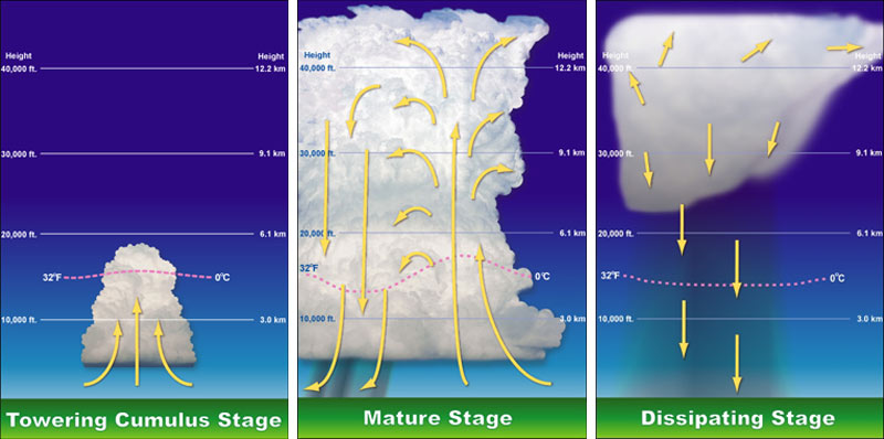
Within the towering clouds that make up a thunderstorm are updrafts and downdrafts - basically, vertical rivers of air that carry precipitation high into the cloud and then unload it on those below. In the formative stages of a thunderstorm, the updraft dominates as the clouds grow. In a mature storm, updrafts and downdrafts are relatively equally balanced.  As the downdraft begins to dominate, the storm falls apart and "rains itself out."  The diagram below demonstrates this well, with the yellow arrows showing the direction of the air flow.

The stages of a thunderstorm, showing the role of downdrafts and updrafts

The downdrafts from mature and dissipating storms rush towards the ground and, if not caught by an updraft forcing the air back up, come crashing to the ground, sometimes with great force.  When the air hits the ground, it obviously does not penetrate the earth, it spreads out, typically in all directions.  The rush of thunderstorm air outwards from the downdraft is called an outflow boundary, or gust front.  (Side note: another name for strong downdrafts that create very gusty wind at the ground are microbursts.  They are the cause of much of the straight-line wind damage that is caused by summer storms, including the trees and power poles damaged this afternoon in Cordova.)

Because the air that originated from the thunderstorm and is rushing out behind the outflow is cooler than the air it is displacing, a mini cold front is, in essence, created along that boundary or gust front.  Cold fronts that encounter warm humid air, untouched by a thunderstorm outflow, can cause new storms to form, just as the storms they originated from are dissipating.

This was very evident late this afternoon as shown in the radar loop below.  The outflow boundaries are the thin blue lines expanding from the storms (air rushing away from the storms that produced the downdrafts).  As they encounter virgin air that was in the 80s, new storms form on the boundaries.  Watch the loop a few times and see for yourself!


Outflow Boundary 102

So why do the outflow boundaries appear as thin blue lines on radar? First, the blue color is simply one of the lowest values on the radar scale used in this loop. So how are they even detected? Remember that radar detects not only precipitation, but anything in the air, even very small particles that we may not see with the naked eye, that reflects radar energy back to the radar dish. In this case, the gusty wind is picking up dust, dirt, and other small objects like bugs (!). Those objects are detected by the radar just as raindrops are.  Because they "float along" on the leading edge of the outflow boundary, they make it easy to detect exactly where the boundary is without looking at the radar velocity (wind) product to see which way the wind is actually blowing!

Another detailed description of outflow boundaries/gust fronts, with radar imagery and photographs to illustrate, can be found in this previous post from the MWN Blog.  To view the loop above in a separate window, click here.

----
Follow MWN on Facebook, Twitter, and Google+ Visit MemphisWeather.net on the web or m.memphisweather.net on your mobile phone. Download our iPhone or Android apps, featuring a fresh new interface and StormWatch+ severe weather alerts!

Friday, July 27, 2012

What is an outflow boundary or gust front?

The question has come up numerous times the past few times we've had storms in the Mid-South: "What is a gust front / outflow boundary?"  On our social media channels, we often refer to these features during nowcasting stints as they are an important part of the life cycle of summertime (especially) storms and can affect you in ways that are noticeable.  

In the course of a thunderstorm's lifetime, there is birth and death (or generation and collapse).  Thunderstorms contain updrafts of wind that push miles into the sky, creating billowing clouds, and downdrafts often associated with falling precipitation.  The updrafts also eventually become downdrafts, meaning the air is now rushing back towards the ground. When the rush of air hits the ground, it is commonly called a downburst or microburst and spreads out along the ground (as it can't go through the earth).

This creates an outflow of cooler air from the storm (remember the air originates miles up in the sky where it is much cooler).  As the outflow propagates away from the parent storm, it creates a boundary between the cooler more stable "outflow" wind and the surrounding air that it is moving into.  This is the outflow boundary or gust front (or in storm spotting/chasing lingo, the forward flank downdraft).


Because the outflow typically has gusty and turbulent wind conditions, it picks up dust from fields, insects, small children (ok, not really) and any other light objects that can be pushed along with the wind.  Doppler radar is able to detect the objects (even dust in large enough quantities) caught up in the outflow boundary, which becomes visible to radar-watchers as a narrow line of light returns (or thin line).  Below is a screenshot from StormView Radar taken Thursday night as a large outflow boundary moved across the Memphis metro.  Note the green worm-like line labeled with red arrows. Voila - an outflow boundary!


The other thing typically detectable by radar along an outflow boundary is low-level clouds.  Because two air masses are colliding (the cooler outflow-generated airmass and the warmer surrounding air ahead of the outflow), clouds are generated as the warmer air rises over the cooler outflow air. Rising air promotes cooling and condensation, thereby creating clouds.  With the strongest outflows, the type of cloud created is the shelf cloud, aptly named as it typically resembles a shelf in the sky.  Below is an approaching shelf cloud along an outflow boundary.  This picture was taken in Paragould, AR late yesterday afternoon before it made the long trek to the Memphis metro (same storm system). 

Shelf cloud, photographed by Pam Whitaker. Paragould, AR.

It's not unusual to see variations of this cloud type along outflow boundaries.  Sometimes they look very sinister, as they are often dark, low, and stretch for miles.  However, the clouds themselves usually pose no threat (in fact, many times there is not even rain in them).  But if one of these is coming your way, be prepared for gusty wind behind it, blowing from the direction in which the shelf cloud is moving from.

You'll also typically notice drops in the temperature, somewhat drier (less humid) air, and often rising pressure. Often the storms that generated the outflow may not be far behind the shelf, so also be prepared for stormy weather!  In the case of the outflow depicted on radar above, temperatures dropped about 10 degrees, dewpoints fell 5-6 degrees (hence, drier air), and the wind shifted to the northwest gusting to 30 mph or more.

The outflow boundary passed the MWN sensors in Bartlett about 9:30pm. Note the red arrow, indicating the passage of the outflow. Temps fell from the upper 80s to upper 70s and dewpoint fell from 75 to about 68 degrees.
Even if the outflow has moved well away from the storms that created it, the rising air along the leading edge of the boundary can often create new storms in the wake of the boundary, hence re-starting the thunderstorm life cycle! 

Watch the video below to see a time-lapse of an outflow boundary and associated shelf cloud move over Bartlett, TN in June.


----
Visit MemphisWeather.net on the web or m.memphisweather.net on your mobile phone.
Download our iPhone or Android apps,  now with StormWatch+!
Nowcasting services available on our Facebook page and Twitter feed.

Saturday, June 19, 2010

Radar & satellite detect large outflow boundary nearing the metro


A large thunderstorm complex rumbled through the Ohio Valley overnight, producing a very large outflow boundary that can easily be seen on visible satellite this morning, as well as on Memphis-based radar. The first image above shows the visible satellite as of about 7:30am. Note the roughly east-west cloud line across the middle of west TN and northeast AR, extending back into the Ozarks. The radar image below that is from 8:05am and shows a dark blue (with a little green) line from Milan to north of Covington to Marked Tree and on to near Searcy.

The outflow boundary is a wind shift with slightly drier and cooler air (very slightly) behind it according to weather observations on the back side of it. It is a line of convergence in the lower atmosphere so it has produced a line of clouds that can be seen on satellite and radar. The radar signature is also enhanced by dust, bugs, and other very lightweight objects that are picked up by the wind along the front/outflow.

This outflow will likely move through the metro area in the next hour or so, but other than some clouds, I expect little effect on our sensible weather (temperature, humidity) other than a temporary wind shift to the north. The outflow will likely weaken as it continues to move south, but could be enough to be the spark for isolated t'storms this afternoon, likely across north MS.

For a current looping radar view of the outflow, click "Current Radar and Satellite" on the tab above or click here.

----
Get the latest weather conditions and much more by checking out MemphisWeather.net on Facebook and Twitter!