Tuesday, March 17, 2020

How long will the wet pattern continue? And will spring's arrival bring warmer weather?

Over the past week we saw rain four out of the last seven days. Today (Tuesday) we got into the mid 60s after rain cleared out for some afternoon sun. Unfortunately, it looks like that trend of rain and storms will continue for the next week. We are watching potential severe weather with a passing of a cold front Thursday and into Friday. More rain could occur at the start of next week (Sunday, Monday, and Tuesday).

This is a picture of a severe thunderstorm in Mountainair, New Mexico. This thunderstorm produced a small tornado about 30 minutes prior, before becoming more linear in nature. This linear nature lead to some wind reports. 

Wednesday

As clouds move in during the overnight hours tonight, temperatures will probably stay relatively steady and only drop to the mid 50s. During the day we will top out in the mid to upper 70s, with a chance of a few showers and storms. This chance of showers and storms is due to some instability which should be present in the atmosphere, as well as warm temperatures due to the metro being in the "warm sector" with a warm front lifting well to our north. Going into Wednesday night, rain chances will stay relatively steady, and the same goes for Thursday morning. Temperatures will only drop to the mid 60s overnight.

Thursday and Friday
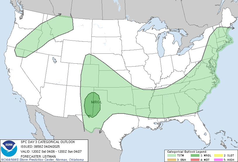
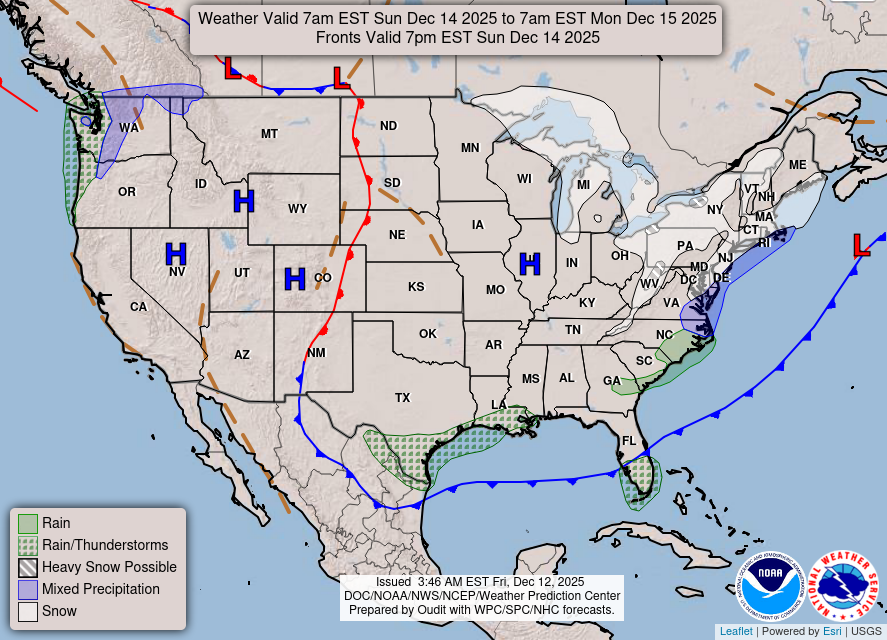
Thursday will likely top out in the upper 70s ahead of an approaching cold front - spring-like temperatures as the solstice occurs late Thursday evening (10:49pm to be exact)! As it moves towards us the chance for rain and storms increases. Storms in our area could be strong to severe as the Storm Prediction Center (SPC) has put Memphis in a Slight Risk (level 2 of 5) for severe storms. This event looks like it will occur late Thursday afternoon/night, so make sure you have multiple ways of getting warning information!  As of right now the storms look more linear in nature meaning the main concern will likely be high wind gusts. Thursday night into Friday temps will stay steady and only drop to the mid 60s, with the Friday daytime high expected to reach around 70 before possibly falling some in the afternoon behind the cold front. Much of the day Friday looks to remain dry and Friday night temperatures will quickly drop.
Day 3 image not available
The Weather Predictions Center (WPC) highlights the chance for severe weather with the expected cold front passage.
Per the SPC, Memphis is near the eastern edge of  a Slight Risk for severe storms on Thursday.

Saturday and Sunday
Early Saturday morning lows will likely drop all the way down to around 40 due to the passage of the cold front. This will make Saturday rather chilly with highs in the low 50s. This trend will continue into Sunday as Sunday morning lows are expected to get down to around 40 as well. There also looks to be a slight rain/shower chance on Sunday as highs only get into the low 50s. Sunday night low temps will drop to the mid 40s.

Monday and Tuesday

Monday looks like it'll be mostly cloudy with a chance of showers as temperatures top out into the lower 60s. Monday night won't get too cold because of the expected cloud cover. This means temperatures will only drop to the lows 50s. Tuesday temps will top out in the upper 60s with a chance of rain or thunderstorms as southerly wind returns, helping temperatures to warm despite the cloud cover.

Relation of Temperature and Cloud Cover
The reason thick clouds keep temperatures warmer during the night is due to the clouds having the ability to keep the Earth's emitted longwave energy in the lower atmosphere. The result is warmer temps than if there were no clouds. This is different when we're talking about daytime highs. If there is a thick cloud deck, temperatures will not get warm as if there were no clouds because those clouds keep the incoming radiation from the sun out. This incoming radiation is called incoming shortwave radiation.

This is a graphic showing what was explained just above. It shows hows clouds can modify daily temperature maximums and minimums.


A Look at Week Two
The Climate Prediction Center (CPC) is expecting March 25th-March 31st to feature above average temperatures and slightly above normal precipitation. I know this is frustrating for some because we have sat above average in the temperature department for most of the winter. This trend looks like it'll continue into early spring. It also looks like the wet trend will stay with us as it has most of this winter.

Latest 8 to 14 Day Temperature Outlook
From the CPC: it looks like the week of March 25th to March 31st has a decent chance of having above average temperatures.
Latest 8 to 14 Day Precipitation Outlook
During the week of March 25th to March 31st, precipitation could also remain a bit above average. (CPC)

Max Magness
MWN Meteorologist Intern

----
Follow MWN on Facebook and Twitter for routine updates and the latest info!
Complete MWN Forecast: MemphisWeather.net on the mobile web or via the MWN mobile app
Download our iPhone or Android apps, featuring StormWatch+ severe weather alerts!
MWN is a NOAA Weather Ready Nation Ambassador Meteorologist Erik Proseus is an NWA Digital Seal Holder

Tuesday, March 10, 2020

February 2020 Climate Data for Memphis, TN

February Climate Recap

December and January temperatures were well above average to start the winter of 2019-2020. February pulled back to near-average for the month with a mix of above and below normal days as fronts passed through regularly. Wet weather from January persisted into February, ending nearly two inches above average. There was one snow "event" with totals of up to an inch across the metro on the night of the 6th. Flurries also fell on the 20th. Thunderstorms occurred on the 5th, 9th, 10th, 18th, and 24th, though no severe weather was observed.

The U.S. temperature anomaly (departure from normal) for the month of February shows well below normal temperatures from the Rocky Mountains into the southern plains. Excessive warmth was found in the west and northeast with mixed temperatures in the flyover states. (WeatherBell)
For the period of meteorological winter (December-February), temperatures averaged 46.7 degrees or 3.3 degrees above normal and 14th warmest on record. Precipitation totaled 16.28",  2.17" above normal and in the top 25% wettest winters on record. Snowfall totaled 0.6 inches, all falling in the snow event on February 6-7.

Memphis International Airport, Memphis, TN


Temperature
Average temperature: 45.7 degrees (0.2 degrees above average)
Average high temperature: 54.2 degrees (0.5 degrees below average)
Average low temperature: 37.1 degrees (0.8 degrees above average)
Warmest temperature: 70 degrees (2nd, 9th)
Coolest temperature: 22 degrees (14th)
Heating Degrees Days: 555 (7 above average)
Cooling Degree Days: 0 (2 below average)
Records set or tied:  None.
Comments: No days recorded a low temperature at or below freezing, which is roughly one day less than average for the month.

Precipitation
Monthly total: 6.34" (1.95" above average)
Days with measurable precipitation: 15 (5.8 days above average)
Wettest 24-hour period: 1.32" (4th)
Snowfall: 0.6" (0.7" below average)
Records set or tied: None.
Comments: Two days had rainfall exceeding one inch, but six days exceeded one-half inch.

Miscellaneous
Peak wind: Northwest/51 mph (12th)
Average wind: 9.2 mph
Average relative humidity: 71%
Average sky cover: 70%

Click here for a daily statistical recap for Memphis International Airport.

Cirrus Weather Solutions / MemphisWeather.net, Bartlett, TN


Temperature
Average temperature: 45.0 degrees
Average high temperature: 53.5 degrees
Average low temperature: 35.7 degrees
Warmest temperature: 70.1 degrees (2nd)
Coolest temperature: 21.1 degrees (14th)
Comments: None

Precipitation
Monthly total: 5.30" (automated rain gauge), 6.14" (manual CoCoRaHS rain gauge)
Days with measurable precipitation: 14
Wettest date: 1.36" (4th) (via automated gauge)
Snowfall: 1.0"
Comments: 1.0" of snow fell on the night of the 6th/7th and flurries were observed on the 20th.

Miscellaneous
Peak wind: Northwest/25 mph (12th)
Average relative humidity: 78%
Average barometric pressure: 30.10 in. Hg
Comments: None

Click here for a daily statistical recap for Bartlett, TN.

MWN Forecast Accuracy

MWN average temperature error: 2.12 degrees
MWN forecast temperatures within 2 degrees of actual: 66%
MWN average dewpoint error: 1.86 degrees
MWN forecast dewpoints within 2 degrees of actual: 71%

MWN's forecasts extend out five periods (2.5 days, or roughly 60 hours). Historical accuracy statistics can be found here.

Climate Outlook - March 2020

The March climate outlook for the United States from the Climate Prediction Center is shown below. Above average temperatures are forecast for the eastern two-thirds of the U.S., particularly over the Midwest to Mid-South. Near average temperatures are expected in the western U.S. Odds favor above average temperatures for Memphis, at 62% (versus only a 5% chance of below average temperatures). Memphis averages 54.0 degrees for the month.


Wetter than normal weather is expected for the Ohio and Tennessee Valleys, as well as the desert southwest. Below average precipitation is forecast for the Front Range. For Memphis, odds favor above average rainfall (47% chance), which historically averages 5.16 inches.

----
Follow MWN on Facebook and Twitter for routine updates and the latest info!
Complete MWN Forecast: MemphisWeather.net on the mobile web or via the MWN mobile app
Download our iPhone or Android apps, featuring StormWatch+ severe weather alerts!
MWN is a NOAA Weather Ready Nation Ambassador Meteorologist Erik Proseus is an NWA Digital Seal Holder