Showing posts with label gust front. Show all posts

Wednesday, June 19, 2013

Primer on outflow boundaries and how they played a role in today's storms

Outflow boundaries can be really cool to watch in action.  They seem to have a life of their own, even though it is somewhat predictable.  Here's some background on what they are, how they form, and how they played into today's storms over the metro.

Outflow Boundary 101

Within the towering clouds that make up a thunderstorm are updrafts and downdrafts - basically, vertical rivers of air that carry precipitation high into the cloud and then unload it on those below. In the formative stages of a thunderstorm, the updraft dominates as the clouds grow. In a mature storm, updrafts and downdrafts are relatively equally balanced.  As the downdraft begins to dominate, the storm falls apart and "rains itself out."  The diagram below demonstrates this well, with the yellow arrows showing the direction of the air flow.
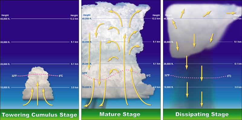
The stages of a thunderstorm, showing the role of downdrafts and updrafts

The downdrafts from mature and dissipating storms rush towards the ground and, if not caught by an updraft forcing the air back up, come crashing to the ground, sometimes with great force.  When the air hits the ground, it obviously does not penetrate the earth, it spreads out, typically in all directions.  The rush of thunderstorm air outwards from the downdraft is called an outflow boundary, or gust front.  (Side note: another name for strong downdrafts that create very gusty wind at the ground are microbursts.  They are the cause of much of the straight-line wind damage that is caused by summer storms, including the trees and power poles damaged this afternoon in Cordova.)

Because the air that originated from the thunderstorm and is rushing out behind the outflow is cooler than the air it is displacing, a mini cold front is, in essence, created along that boundary or gust front.  Cold fronts that encounter warm humid air, untouched by a thunderstorm outflow, can cause new storms to form, just as the storms they originated from are dissipating.

This was very evident late this afternoon as shown in the radar loop below.  The outflow boundaries are the thin blue lines expanding from the storms (air rushing away from the storms that produced the downdrafts).  As they encounter virgin air that was in the 80s, new storms form on the boundaries.  Watch the loop a few times and see for yourself!


Outflow Boundary 102

So why do the outflow boundaries appear as thin blue lines on radar? First, the blue color is simply one of the lowest values on the radar scale used in this loop. So how are they even detected? Remember that radar detects not only precipitation, but anything in the air, even very small particles that we may not see with the naked eye, that reflects radar energy back to the radar dish. In this case, the gusty wind is picking up dust, dirt, and other small objects like bugs (!). Those objects are detected by the radar just as raindrops are.  Because they "float along" on the leading edge of the outflow boundary, they make it easy to detect exactly where the boundary is without looking at the radar velocity (wind) product to see which way the wind is actually blowing!

Another detailed description of outflow boundaries/gust fronts, with radar imagery and photographs to illustrate, can be found in this previous post from the MWN Blog.  To view the loop above in a separate window, click here.

----
Follow MWN on Facebook, Twitter, and Google+ Visit MemphisWeather.net on the web or m.memphisweather.net on your mobile phone. Download our iPhone or Android apps, featuring a fresh new interface and StormWatch+ severe weather alerts!

Friday, July 27, 2012

What is an outflow boundary or gust front?

The question has come up numerous times the past few times we've had storms in the Mid-South: "What is a gust front / outflow boundary?"  On our social media channels, we often refer to these features during nowcasting stints as they are an important part of the life cycle of summertime (especially) storms and can affect you in ways that are noticeable.  

In the course of a thunderstorm's lifetime, there is birth and death (or generation and collapse).  Thunderstorms contain updrafts of wind that push miles into the sky, creating billowing clouds, and downdrafts often associated with falling precipitation.  The updrafts also eventually become downdrafts, meaning the air is now rushing back towards the ground. When the rush of air hits the ground, it is commonly called a downburst or microburst and spreads out along the ground (as it can't go through the earth).

This creates an outflow of cooler air from the storm (remember the air originates miles up in the sky where it is much cooler).  As the outflow propagates away from the parent storm, it creates a boundary between the cooler more stable "outflow" wind and the surrounding air that it is moving into.  This is the outflow boundary or gust front (or in storm spotting/chasing lingo, the forward flank downdraft).


Because the outflow typically has gusty and turbulent wind conditions, it picks up dust from fields, insects, small children (ok, not really) and any other light objects that can be pushed along with the wind.  Doppler radar is able to detect the objects (even dust in large enough quantities) caught up in the outflow boundary, which becomes visible to radar-watchers as a narrow line of light returns (or thin line).  Below is a screenshot from StormView Radar taken Thursday night as a large outflow boundary moved across the Memphis metro.  Note the green worm-like line labeled with red arrows. Voila - an outflow boundary!


The other thing typically detectable by radar along an outflow boundary is low-level clouds.  Because two air masses are colliding (the cooler outflow-generated airmass and the warmer surrounding air ahead of the outflow), clouds are generated as the warmer air rises over the cooler outflow air. Rising air promotes cooling and condensation, thereby creating clouds.  With the strongest outflows, the type of cloud created is the shelf cloud, aptly named as it typically resembles a shelf in the sky.  Below is an approaching shelf cloud along an outflow boundary.  This picture was taken in Paragould, AR late yesterday afternoon before it made the long trek to the Memphis metro (same storm system). 

Shelf cloud, photographed by Pam Whitaker. Paragould, AR.

It's not unusual to see variations of this cloud type along outflow boundaries.  Sometimes they look very sinister, as they are often dark, low, and stretch for miles.  However, the clouds themselves usually pose no threat (in fact, many times there is not even rain in them).  But if one of these is coming your way, be prepared for gusty wind behind it, blowing from the direction in which the shelf cloud is moving from.

You'll also typically notice drops in the temperature, somewhat drier (less humid) air, and often rising pressure. Often the storms that generated the outflow may not be far behind the shelf, so also be prepared for stormy weather!  In the case of the outflow depicted on radar above, temperatures dropped about 10 degrees, dewpoints fell 5-6 degrees (hence, drier air), and the wind shifted to the northwest gusting to 30 mph or more.

The outflow boundary passed the MWN sensors in Bartlett about 9:30pm. Note the red arrow, indicating the passage of the outflow. Temps fell from the upper 80s to upper 70s and dewpoint fell from 75 to about 68 degrees.
Even if the outflow has moved well away from the storms that created it, the rising air along the leading edge of the boundary can often create new storms in the wake of the boundary, hence re-starting the thunderstorm life cycle! 

Watch the video below to see a time-lapse of an outflow boundary and associated shelf cloud move over Bartlett, TN in June.


----
Visit MemphisWeather.net on the web or m.memphisweather.net on your mobile phone.
Download our iPhone or Android apps,  now with StormWatch+!
Nowcasting services available on our Facebook page and Twitter feed.

Friday, August 21, 2009

Video of Thursday morning's weather

Many of you who were getting ready to leave for, or on your way to, work or school Thursday morning will recall the very ominous cloud bank that moved into the metro area in the 7am hour, enveloping the area in clouds worthy of a Weather Channel special. The arrival of this massive outflow (learn more about outflow boundaries and gust fronts in my previous posts) was accompanied by gusty northwest wind (30-40 mph in many cases) and then bands of heavy rain for the next 30 minutes or so.

Well, my good friend and owner of Gemini Media Transfer Service got the video camera out and mounted it in his driveway in Bartlett and let it run, then time-lapsed the 30 minutes of film into a one-minute quick flick. The results are below. Amazing video - and a time-lapse makes it even cooler. Thanks to Ande and Gemini MTS for capturing it and allowing me to share with you.


----
Become a fan of MemphisWeather.net on Facebook and follow MWN on Twitter!

Thursday, August 20, 2009

Life cycle of summertime diurnal thunderstorms

On Tuesday evening (8-18-09), thunderstorms erupted over the greater Memphis area, dropping flooding rains (due to very slow movement of the cells) and creating copious cloud-to-ground lightning. These storms provide the opporunity to describe the classic life cycle of diurnal ("heating of the day") thunderstorms.

The typical life cycle of single cell thunderstorms, or small clusters of storms, on a hot summer day involves initial growth of a few cells which then produce an "outflow boundary," or gust front, as the storm falls apart. A downrush of air from a collapsing thunderstorm reaches the ground and spreads out, generally in all directions. The leading edge of this cooler airmass (or outflow) is the outflow boundary or gust front. See the life cycle diagram below and note the downrush of air in the dissipating stage (image courtesy: Wikipedia).


The outflow boundary itself serves to ignite new storms (or intensify existing cells) as it acts much like a cold front with converging air on its leading edge and cooler air displacing warmer air, which then rises. As the warmer air rises, clouds form and with enough lift, new showers or storms can form. The new storms mature, then collapse, creating their own outflow, and the cycle continues. See the diagram from Wikipedia below.

This is exactly what happened on Tuesday evening. The radar imagery captured that evening shows just how these types of storms have their own life cycle, using energy from nearby collapsing storms to invigorate existing storms or create new growth. The gust fronts in this movie loop are seen as thin blue lines eminating out from the larger cells. Notice that as they reach younger cells, those cells intensify (notice in particular the new storms that fire up just north of Millington and showers in central Shelby County that explode as the southward moving outflow boundary passes through those areas, causing rapid growth just east of Bartlett along I-40 [the red line]).


----
Become a fan of MemphisWeather.net on Facebook and follow MWN on Twitter!

Monday, August 10, 2009

Quick-hitting front blows through Shelby and Tipton counties


Photos taken of the gust front / thunderstorm outflow as it quickly approached from the northwest, then engulfed the north Bartlett area. Right on its heels, a pretty good thunderstorm with 30-40 mph wind and heavy rain moved overhead. Over .25" of rain was measured in just 15 minutes with the storm.

You can also view a time-lapse video of the front below. You will see first see the initial clouds come in from the west, then the front itself appears out of the northwest and "boils" overhead as eddies in the turbulent atmosphere seem to "roll out" from under the front. The strong wind is evident as well in the trees as the front crosses over. Great footage and editing by ANDe of Gemini Media Transfer Services!


----
Become a fan of MemphisWeather.net on Facebook and follow MWN on Twitter!

Tuesday, April 21, 2009

Movie of gust front passage


This movie is a time-lapse of a gust frontal passage I videoed on July 10, 2008 from my home in Bartlett, TN. You'll have to pardon some of the movement at ground level - keep your eyes on the front as it moves from northwest to southeast, passing overhead at about 5pm. My original post on this event, with still shots, can be found here.

Gust fronts are basically just outflows from thunderstorms. Air rushing down out of a thunderstorm encounters the ground and spreads out in all directions (typically). The leading edge of that rush of air is termed the "thunderstorm outflow" or "gust front." Strong gust fronts, with a significant wind shift trailing them, can frequently look very ominous.

The time-lapse, showing about 9 minutes of video in 30 seconds, was very professionally done by my good friend ANDe, owner of Gemini Media Transfer Service in Bartlett. Check out Gemini MTS (click here for Gemini MTS on Facebook) if you want to get those old home movies or slides converted to DVD or have some professional-quality video editing done!

Friday, July 11, 2008

Gust front passage

Took these pictures about 4:45pm yesterday (7/10/08). Scattered thunderstorms were in the area and one happened to put out a nice outflow/gust front ahead of it. The gust front tracked right over the house and my weather station. As dark as the clouds were, and ominous as it looked, there was no rain with the front, though the remnants of the dying storm that initiated the front did pass over and drop 0.04" of rain a few minutes later. Pretty nice looking shelf cloud along that front. All of the classic weather conditions occurred with the frontal passage - slight pressure rise, temperature drop, wind shift and increase, followed by a brief downpour.