Friday, July 28, 2023

Late summer heat builds, offset only by a few thunderstorm chances

After a stint of temperatures near or below average, we've turned a corner as we near the end of July with a stretch of highs in the mid to upper 90s is on its way to the Mid-South this weekend and next week. Grab your favorite frozen treat and let’s dive into the forecast!

Friday evening-Saturday

We’ll wrap up the work week hot and dry and continue that pattern to start the weekend. Saturday, highs will reach 97 under mostly sunny skies. Combined with humidity, heat index values will be near 105. A heat advisory will be continued into Saturday due to this potentially-dangerous heat.

Forecasted highs on Saturday will range in the mid to upper 90s. (NWS Memphis)

Sunday

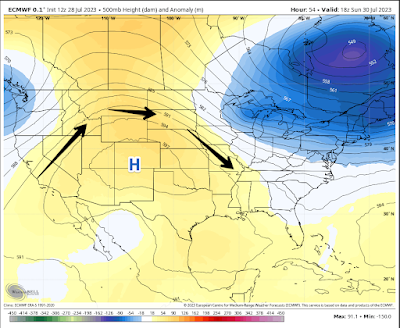
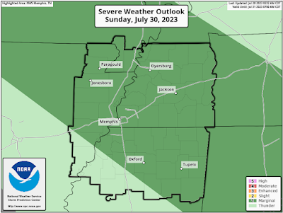
The clockwise flow around a high pressure aloft over the Four Corners region will usher in a northwest wind on Sunday. A disturbance along this flow will be funneled into our area to provide the chance for afternoon storms. Given how hot and humid it’ll be, these storms could be gullywashers and have the chance to be strong to severe. At this time, all of us are under a level 1/5 “marginal” risk for severe weather.
The ECMWF (European) model shows a ridge of high pressure over the Four Corners region Sunday afternoon. Since Memphis is on the east side of the high, clockwise rotation will bring us a northwest wind. (WeatherBell)


A Marginal Risk of severe weather is currently forecast for the metro on Sunday. (NOAA/SPC)

Monday - Tuesday

A "cold" front will pass late Sunday into early Monday. So, we lose the chance for rain to start the week, but otherwise, it’ll be a carbon copy of Sunday. Highs won’t take a noticeable dive behind this front and will return to the mid 90s again. Behind the cold front’s passage, northwest flow will be reestablished on Tuesday. With that comes the chance for storms once again. Highs will be in the mid 90s.

Wednesday - Friday

A chance of storms remains for Wednesday, but the ridge of high pressure will push east into the lower Mississippi Valley for the end of next week. When that happens, we’ll drop the chance for rain and be left with brutal heat! Highs for Thursday and Friday will jump into the upper 90s. Let’s all cross our fingers and hope we don’t reach the century mark! 


Owen Basselman
MWN Intern

----
Follow MWN on Facebook and Twitter for routine updates and the latest info!
Complete MWN Forecast: MemphisWeather.net on the mobile web or via the MWN mobile app
Download our iPhone or Android apps, featuring StormWatch+ severe weather alerts!
MWN is a NOAA Weather Ready Nation Ambassador Meteorologist Erik Proseus is an NWA Digital Seal Holder

Tuesday, July 4, 2023

June 2023 Climate Report for Memphis, TN

June Climate Recap

Following a slightly warmer than average month of May, June turned relatively cooler versus normal after the first week of the month, which started with high temperatures in the 90s. After the 6th, all but three days were at or below average from a temperature perspective, and two of those were the last two days of the month.


Contributing to the slightly below normal temperatures was above average rainfall, which eliminated the low-end drought conditions that existed at the start of the month. Rain fell on eleven days during the month (two more than average) and rainfall totaled almost five and a half inches for the month. Multiple rounds of severe weather occurred as well. The biggest of those events occurred on the evening of the 25th as a complex of severe storms brought 80-90 mph wind to northern Shelby County, downing trees and power lines and knocking out power to over 120,000 utility customers in Shelby County, as well as many in Fayette County. It would take well over a week to restore all power. 

One of hundreds of uprooted trees across the metro after severe storms swept through on the evening of June 25, 2023. (Photo: Erik Proseus, MWN)


Additional severe storms occurred on the 18th, as wind peaked at 57 mph at Memphis International Airport, as well as the 5th, 11th, and 16th, which produced wind damage and hail in various areas of the metro.

Memphis International Airport, Memphis, TN

Temperature 
Average temperature: 79.4 degrees (0.5 degrees below average) 
Average high temperature: 88.8 degrees (0.6 degrees below average) 
Average low temperature: 70.0 degrees (0.4 degrees below average) 
Warmest temperature: 97 degrees (30th) 
Coolest temperature: 64 degrees (7th and 13th) 
Heating Degrees Days: 0
Cooling Degree Days: 439 (8 below average) 
Records set or tied: Record high minimum tied (81 degrees on the 29th)
Comments: Fifteen days reached 90 degrees, which is 0.5 days below average for the month of June

Precipitation 
Monthly total: 5.40" (1.41" above average) 
Days with measurable precipitation: 11 (2.1 days above average) 
Wettest 24-hour period: 2.15" (18th) 
Snowfall: None
Records set or tied: Record daily rainfall (1.75" on the 16th)
Comments: None

Miscellaneous 
Peak wind: West/57 mph (18th) 
Average wind: 6.3 mph 
Average relative humidity: 67%
Average sky cover: 42%

 Click here for a daily statistical recap for Memphis International Airport.
 

MemphisWeather.net Headquarters, Bartlett, TN

Temperature 
Average temperature: 76.4 degrees 
Average high temperature: 89.8 degrees 
Average low temperature: 67.2 degrees 
Warmest temperature: 99.7 degrees (30th) 
Coolest temperature: 60.1 degrees (13th) 
Comments: None 

Precipitation 
Monthly total: 4.86" (automated rain gauge), 4.54" (CoCoRaHS rain gauge) 
Days with measurable precipitation: 9
Wettest date: 1.28" (18th) (via automated gauge) 
Snowfall: None
Comments: None

Miscellaneous 
Peak wind: Northwest/47mph (2nd)
Average relative humidity: 74% 
Average barometric pressure: 29.85in. Hg
Comments: None

Click here for a daily statistical recap for Bartlett, TN.
 

MWN Forecast Accuracy

MWN average temperature error: 1.84 degrees 
MWN forecast temperatures within 2 degrees of actual: 68% 
MWN average dewpoint error: 2.17 degrees 
MWN forecast dewpoints within 2 degrees of actual: 65% 

MWN's forecasts extend out five periods (2.5 days, or roughly 60 hours). Historical accuracy statistics can be found here.

----
Follow MWN on Facebook and Twitter for routine updates and the latest info!
Complete MWN Forecast: MemphisWeather.net on the mobile web or via the MWN mobile app
Download our iPhone or Android apps, featuring StormWatch+ severe weather alerts!
MWN is a NOAA Weather Ready Nation Ambassador Meteorologist Erik Proseus is an NWA Digital Seal Holder