Showing posts with label forecast. Show all posts

Sunday, April 10, 2016

UPDATED: Weather to plan your week around for the first week of April

I decided to give something new a try on this blog post written Sunday night. I'm going to let you know each day how I did and provide meaningful updates as necessary to the next day's forecast. Yep, total transparency! Something no one running for office can promise AND deliver... You'll see the daily updates in red below. Read on...


ORIGINAL POST - Sunday, April 3, 8:23pm

It's been a very busy few days on top of nursing a sore back, so this blog will be brief and to the point. Fortunately, there's not a lot "out of the ordinary" to talk about relative to this week's weather. It's early April when temps average 70/50 (high/low) but large swings are not at all uncommon. Thankfully, we really aren't expecting any severe weather in the next week, despite three cold frontal passages. We also aren't forecasting any heavy rainfall like those that contributed to the wettest month of March on record! Let's take the week day-by-day.

Monday

Tomorrow will be a warm sector day ahead of an approaching cold front that will only deliver a glancing blow to the Mid-South as the parent low pressure system moves by well to the north. Only a few clouds are expected as moisture remains very limited with the front that arrives late Monday. Highs will be well into the 70s after lows remain near or above 50. With mostly sunny skies, a nice day to do something outside, unless you're working, then we recommend a long patio lunch.

ACTUAL: Anyone see any clouds today? Right, just a few this evening trailing the cold front that moved through with stealth, as promised. Today's high was 80 (undershot that one by a few degrees) and the low was 52 (nailed it).


Tuesday

Limited moisture falls even further behind Monday's cold front and temperatures will be about 10° cooler, topping out in the mid 60s despite a sunny sky. Morning lows will be in the mid 40s. Wind quickly turns back around to the southeast by Tuesday afternoon, which will have a bearing on Wednesday's weather. (No changes as of Monday night. Right on track.)

ACTUAL: Temperatures overachieved again today (71) under sunny skies, but they were still about 10 degrees cooler than Monday as predicted. The morning low was 51 with outlying areas closer to the mid 40s. Wind was east to southeast this afternoon.

Wednesday

Yet another frontal system moves through late in the day. This one will have a little more moisture to work with, as well as a bit of unstable air ahead of it. Scattered showers are expected, especially in the afternoon, as well as a few thunderstorms. Compared to our cold fronts last week, this one will not have nearly the upper level energy so severe weather is currently not anticipated, nor is widespread heavy rainfall as the system will move through rather quickly. Highs will be near 70 with lows in the lower 50s. Rain will probably be gone by evening, but the upper level pattern shifts behind this front, leading to a change in the pattern for week's end... Very little change for Wednesday (as of Tuesday night). Rain and a few storms are still expected in the afternoon hours, but should not be severe. Temperatures will again run a couple degrees above this forecast.

ACTUAL: Pretty much spot on! Two distinct lines of showers and thunderstorms moved through during the afternoon,. No severe weather occurred, but wind was pretty strong! Rainfall was heavy, but brief with less than 1/2" area-wide. Rain was gone by evening as predicted. Highs were within 2 degrees (72) and lows were accurate for the outlying areas, but stayed warm in the city (near 60).

Thursday

The upper level pattern becomes dominated by an eastern U.S. trough heading into the end of the week, which will mean northwest flow for the Mid-South (upper level wind blowing from northwest to southeast) and temperatures cooling to below April norms. Northwest flow will mean some clouds linger Thursday with a slight chance of a shower. Highs still reach the mid 60s after morning lows in the upper 40s, but a stiff north wind at the surface will make it feel cooler, especially if sunshine is limited. Wednesday night comments: Looks like I expected a slightly stronger trough than we'll end up seeing, with a little more sun and slightly warmer temperatures than predicted. Will be interested to see how this actually pans out.

ACTUAL: Well, I get to use my favorite slogan: "It seemed like a good forecast at the time!" The upper level trough is in position as expected, but more sunshine than expected and some dry air that heats  rather efficiently resulted in a beautiful day with highs in the mid 70s, or 10° above Sunday's prediction. In effect, the cooldown is simply delayed a bit more than expected. Morning lows in the upper 40s was perfect and the breezy northwest wind also materialized as expected. No rain.

Friday

The eastern U.S. upper level trough strengthens, which in turn drops cooler air into the Mid-South. Skies will average partly cloudy but look for highs only near 60, or about 10° below average for this time of year. North wind means a chilly day and the nighttime hours will be cold. Saturday morning lows could drop to near 40 in the city and some frost will be possible in outlying areas. Thursday night comments: Once again, the Sunday night forecast for Friday will be too cool, but probably not a lot - mid 60s versus near 60. Saturday night's temperatures will be as predicted - chilly!

ACTUAL: Mid 60s was the actual high, just a bit above the forecast from Sunday night. The wind was indeed brisk today and tonight's low is right on track with the forecast - lows in the 30s are expected outside the loop, though some wind will keep frost to a minimum.

As I mentioned on Facebook and Twitter Saturday, it's REALLLLY tempting to start planting outdoors, but unless you are planting something hearty, or easy to move to a warmer spot for a night, I strongly suggest waiting until at least next weekend after this cold spell moves through. A gardener told me that it's wise to wait until after Tax Day to plant. Not sure if that has more to do with the warming of the ground and end of potential cool snaps or the status of your bank account when you go to Lowe's or the local nursery, but either way it makes sense.

Saturday and Sunday

Highs rebound fairly well under full April sun with mid 60s expected for highs as wind shifts back towards the south. By Sunday, a developing weather system to our west will mean a slight chance of showers as Gulf moisture starts moving back into the region. Highs should be back near average or slightly above. It looks like early the following week will see out next chance of heavier spring rain and perhaps a few decent thunderstorms. Friday night comments: Saturday will actually be the coolest day of the day with highs in the upper 50s.

ACTUAL: Pretty much dead on for Saturday with sunshine and highs in the mid 60s after a low in the mid 40s. As for Sunday, the slight chance of showers forecast a week ago occurred early in the morning with highs well above average at 81°. The other notable weather event was the very strong south wind.  

For the week, the main points were well-forecast with temperatures averaging above forecast by a category or two for the most part, but with the trends well forecast. The "outlook" for early this coming week, forecast 8 days ago, is also dead on - "heavier spring rain and a few decent thunderstorms." Exactly what I'm expecting tomorrow!

Here's the official MWN Forecast, updated daily (or check it out in our mobile app).

Here's the week wrapped up with a nice little bow on it:


Erik Proseus
MWN Meteorologist

----
Follow MWN on Facebook, Twitter, and Google+
Visit MemphisWeather.net on the web or m.memphisweather.net on your mobile phone.
Download our iPhone or Android apps, featuring StormWatch+ severe weather alerts!
MWN is a NOAA Weather Ready Nation Ambassador Meteorologist Erik Proseus is an NWA Digital Seal Holder

Friday, January 22, 2016

On "busted" forecasts, building trust, and expectations

Have you ever tried to predict the final score of a sports game - basketball, football, or even low-scoring games like soccer - before it began? Probably not, though you may have put money, or maybe just a handshake, on the final score - either an over/under or against the spread.

How hard is it, for example, to predict the total number of points that will be scored in a basketball game before the game begins? I'll even give you a buffer of 5-10 points for a "right" answer. Even right before the game, you don't know how individual players will perform, how external factors will be involved, how the game will be called by the referees, let alone a freak injury to the star player.

And if you have money or your reputation on the line? The stakes grow higher.

It's similar for your local meteorologist trying to predict the amount of snow your backyard will receive. Sure, we have pretty good stats on the factors (players) involved, the predictability can generally be quantified, and we can use history as a guide. But sometimes the key player (an upper level low for instance) suffers a broken face ala Mike Conley. Or more likely, the key player under-performs versus what you would expect for any of a number of reasons, as the "deformation zone" did this morning.

And like the gambler, the stakes are high if you have enough people that rely on your opinion to make decisions that are important to them.

This is not a commentary of excuses. It's not even really a commentary of "reasons." It's more to get a few things off my chest, which maybe I should keep to myself but here they are anyway.

Before I get too far though, I will start by apologizing. I know, I don't have to. But I need to, if for no other reason than to clear my conscience. You don't have to accept it. It doesn't both me one way or the other. It's your problem if you want to hold a grudge, not mine. But I still feel like I owe you an apology because you made plans that either were or weren't necessary, you had hopes and expectations that were dashed, or you had trust in a stated outcome, even if that outcome was caveated (which it was).

If there's one thing I strive to do more than accurately predict the weather, it's to earn and keep your trust. I teach my kids that trust is hard to gain, but easy to lose. I spend hours poring over computer model data, reading and learning to refine my skills, studying social media trends and technique, and diligently answering your questions and comments or anticipating them so I can answer them in a blog before you ask.  Trust is as big a deal to me as nailing a forecast. I work very hard at both. Part of maintaining that trust, in my opinion, is admitting when you are wrong. I was wrong (at least partially considering the entire area I was forecasting for, but maybe for your backyard, completely).

My dilemma, or maybe it's not actually mine, is that some of you have expectations that, honestly, can't be met. Just like you can't predict the final score of a basketball game before it tips, I can't tell you how much snow you'll get in your backyard! It's that simple. No amount of money poured into technology or brilliance of atmospheric scientists with PhD's will produce a computer model that can do that anytime in the near future! (Side note: Though the ultimate position of the axis of heaviest snow didn't quite extend into the metro as far as I predicted, nor did it produce quite as much snow as expected, there were 3" snow reports on the Shelby/Tipton border, which is literally just several miles from those of you who claimed to get "nothing." Higher totals weren't much farther north than that. That means the forecast wasn't actually as bad as your perception of it. But that's not my point here.)

There are also those that seem to not be happy unless the worst happens. In predicting and communicating the weather, we as a weather industry will almost always err on the side of caution. Not to the extent that we're crying wolf intentionally or "hyping," but making sure that the array of possible outcomes we communicate reasonably include some of the credible outliers. There are those who get mad because they didn't get the snow on the highest end of the range or insist that because "it didn't happen at my house" it shouldn't be discussed. I have 3 words: "bless your heart."

Providing all reasonable outcomes allows decision makers (including each of you) to prepare for that outcome. We would rather over-warn than under-warn, because under-warning has much more dire consequences. It's the nature of the business. (Side note on "hype": we don't hype on MWN. Hype requires that I am overstating because there is something in it for me. The services we provide, by and large, are free. I gain nothing, but stand to lose a lot of that trust I talked about above, by overstating intentionally.)

Finally, the other problem that is not mine, but that I have to deal with in this business, is the preponderance of comments that are shared electronically that most human beings would never share to another person's face. We feel like we can hide behind an online "persona" or type whatever we're thinking without filter. I understand it and occasionally have been guilty of it myself, but I try hard to make sure that I don't "share" something in print that I wouldn't say if the person were standing in front of me. Asking kindly for an explanation as to what went wrong with a forecast is one thing, but passive-aggressive statements and outright blame for something I have ZERO control over is uncalled for. Again, "bless your heart."

Some will say, "Well you chose your field and chose to make yourself 'available' to the public by getting on Twitter and Facebook, that's what you get when you screw up!" No, I CHOSE my field because I had a passion for it long before Twitter had been invented. I CHOSE to be on social media because I felt like I had something valuable to offer and it was a means to offer that service. I didn't choose to be thrown under a bus. But, I realize, sometimes that comes with the territory. Meteorologists that have been in the field for any length of time gain a thick skin. We know when we're wrong before you do most of the time because, as a whole, we are as passionate about what we do as any career out there. We judge ourselves before you judge us. Ask just about any meteorologist why they do what they do and it's because they LOVE their job and couldn't imagine doing anything else. When things don't work out, we work to figure out why so we can do better next time.

One last comment: to those who have taken the time to write a note of appreciation or encouragement today, or any other day, THANK YOU. It's why I do this. Together, we'll shake off the haters. :-)

Thanks for reading and for placing your TRUST in MemphisWeather.net. My team and I work hard to provide the very best service possible, but there are definitely times we mess up, and I can guarantee you there will be more! In this business, they are called "opportunities to learn and grow." Someone much more powerful than me is in control, I just try to predict the outcome!

Be safe and enjoy the snow day,

Erik Proseus
MWN Meteorologist

Wednesday, October 7, 2015

MWN Lightning Round: Joaquin forecasts, 1000-year rain, and the weekend forecast


It's time for another edition of the MWN Lightning Round! Today we tackle a couple topics related to recent events on the east coast and tropics, as well as take another quick look at the weekend forecast, which has changed a bit in the past couple of days.

Hurricane Joaquin track forecasts

Early last week, eyes turned towards the warm waters of the Caribbean as Joaquin spun up and quickly became a major hurricane as it churned into the Bahamas where above average warmth and low wind shear aided rapid development. There's been a lot of talk in the aftermath (when you can break through the conversation about SC flooding, which is definitely worthy of plenty of it!) about the performance of the American (GFS) model vs. the European (ECMWF) model.

Once again, the ECMWF handily beat its American counterpart on the forecast track of Joaquin, indicating that the nearly 10-year long streak of no major hurricane landfalls on U.S. shores would remain intact. While the European model nearly pegged the eventual track of the storm as early as Monday night, the GFS didn't release the east coast from its sights until Friday morning (after the storm had reached the Bahamas) and took another 4 model runs (24 hours) to correctly show that there was a higher threat to Bermuda than the Canadian Maritimes. Credit goes to the National Hurricane Center for keeping the official forecast track off the east coast and not issuing tropical watches on U.S. soil in deference to the European model, despite the consensus of the rest of the models showing an eastern U.S. landfall.

The European model forecast for Hurricane Joaquin as of Monday night, September 28th, correctly showing a trip into the central Bahamas, followed by a turn to the northeast, close approach to Bermuda, and eastward turn south of 40° north. Graphic courtesy WeatherBell Analytics. Used with permission.
The American (GFS) model forecast for Tuesday night, September 29th, showing landfall near Norfolk, VA and significant direct impact to the Mid-Atlantic region. This forecast was made 24 hours after the above track produced by the European model. The GFS didn't eliminate direct impact to the U.S. as a possibility until late in the week. Graphic courtesy WeatherBell Analytics.
Having followed these models regularly for years, my primary comment here is this: the American model generally does a very good job in the short to medium-range (out to a week) and compares favorably with the European model in general. However, when the spotlight is on (Hurricanes Sandy and Joaquin immediately come to mind), it has fallen short. What must not be forgotten is that the massive northeast blizzard that was predicted to bury NYC last winter (and ended up being a "regular snowstorm" for a well-prepared northern metropolis) was actually best forecast by the American-made GFS, whereas the European led forecasters astray, at least in the area that gets the most media attention, the Big Apple.

What is a 1,000-year rain event?

Since we're talking about Joaquin, this is a good opportunity to discuss another misunderstood, and unfortunately poorly-explained, topic (at least by the mainstream media) that we've all heard in reference to the historic flooding this past weekend. Portions of South Carolina received a 1,000-year rain event. What does that mean, besides that it is historic, catastrophic, and devastating all at the same time?

Let's start with what it is NOT. First, it was not a 1,000-year FLOOD event. That is different from a 1,000-year RAIN event. A 1,000-year rain event does NOT mean that: a) it's been 1,000 years since the last rain of this magnitude, despite what Stephen Colbert or the Governor of South Carolina says, b) it'll be 1,000 years before this much rain falls again, or c) it only rains this much every 1,000 years.

A 1,000-year rain event actually means that there is a 1/1,000 chance that a certain amount of rain will fall in the given period, or that there is a 0.1% chance of it occurring. Could it occur again next year? Sure! A good way to describe this (and credit to the CoCoRaHS blog for this great example) is to imagine 1,000 ping pong balls in a box. All but one are white, the other is red. With your eyes closed, you pull a random ball out of the box. You have a 1/1,000 (0.1%) chance of grabbing that red ball. You then put that ball back in the box, mix them up, and grab a ball again. Once again, you have a 0.1% chance of pulling the red ball. The fact that you picked it out the first time does NOT affect your chances the subsequent time. Therefore, a 1,000 year rain event may not happen for 2,000 years, or you may see it much more often than every 1,000 years!

The last comment on these "recurrence interval" events, whether 1,000-year, 500-year, or 100-year event, is that the amounts of rain vary significantly from one place to another. For example, for Memphis, a 1,000 year rain event is 10.64" in 24 hours, while in Phoenix, it is 4.82" in 24 hours. Also, average recurrence intervals are calculated not just on 24 hour rainfall amounts, but on several different timeframes. The recurrence intervals for Memphis are shown below. As an example, a 100-year rain event is 8.02" in 24 hours or 3.20" in 1 hour.

Average recurrence intervals for precipitation events for Memphis, TN. Data courtesy City of Memphis/Shelby County Storm Water Management Manual.

Weekend forecast

In a post earlier this week, we discussed the warm weather mid-week (which we're experiencing... mid 80s can leave anytime thank you) and the passage of a cold front on Friday. That post mentioned minimal rain chances with the front, but computer models are picking up on more moisture along and behind the front and we've added a 30% chance of showers and maybe a few thunderstorms to the Friday afternoon forecast, as well as a 40-50% chance of evening showers.

GFS Wednesday morning forecast model of total rainfall for Friday and Friday night. Graphic courtesy WeatherBell Analytics.
The good news: we could really use some rain after a dry month, so a quarter inch of liquid will be welcome for some, plus it'll be gone for the Columbus Day weekend, so expect cooler and drier conditions Saturday and Sunday with clouds departing by mid-day Saturday. The bad news: you might need a poncho or umbrella at any Friday night events outdoors, including football games and the Levitt Shell concert. If forecast trends hold, we could see a steady rain during the evening with north breezes making it feel a fair amount cooler than the daytime hours when highs will reach the lower to mid 80s.

Keep abreast of the latest forecast conditions from MWN with our mobile apps, perfect for checking radar and our human-powered forecast while out and about. Links to download can be found below.

Erik Proseus
MWN Meteorologist

----
Follow MWN on Facebook, Twitter, and Google+
Visit MemphisWeather.net on the web or m.memphisweather.net on your mobile phone.
Download our iPhone or Android apps, featuring StormWatch+ severe weather alerts!

Friday, March 14, 2014

On a cold start to the year, average last freeze dates, and weekend rain


We introduced the MWN Lightning Round about a week ago to provide small bites of weather info that we think would interest our readers.  Today's edition focuses on just how cold it's been so far this year, when (typically) the coldest of the air is behind us, and a quick look ahead at an unsettled weekend.

A cold start to 2014

According to the National Weather Service in Memphis (WebFacebook, Twitter), 2014 is in the Top 10 for coldest starts to a year since 1900.  January averaged just over 5 degrees below normal and February averaged 4.4 degrees below normal, but the first couple of weeks of March have continued the trend, averaging nearly 6 degrees below normal through yesterday.  It's no surprise then that we're moving into the ranks of the coldest years on record, but I didn't realize that it was Top 10 worthy!  Here's the official word from the NWS:


Last freeze dates

Also according to the NWS, we're fast approaching our usual "last freeze date" - or the date that (on average) we see our last 32 degree reading of the spring.  For Memphis, that date is March 19 (and according to the MWN Forecast, we may get close to freezing again on Monday/St. Patty's Day, so that is not unusual).  Though the climate record is not nearly as long, the Agricenter's average last freeze is March 28, so folks in outlying areas especially still have another couple of weeks when a freeze is not at all unusual.  Spring cold fronts often bring a shot of cold, dry Canadian air that can drop temperatures to 32.  The good thing about cold weather in March is that it typically doesn't last long.


Weekend weather

As a perfect segue from the cold weather talk, this weekend's rainy but mild weather will be followed by a brief cold spell. As an example of the typically-brief cold spells discussed above, the low Monday morning will be near freezing, but by Tuesday afternoon we'll be well into the 60s again!  Until then, though, we'll be dealing with a series of disturbances/low pressure systems that will track through the region.  While temperatures in the mid to upper 60s are expected this afternoon and tomorrow, rain (some of it occasionally heavy) will move over late Saturday into Sunday morning.

It appears we may get "dry-slotted" for part of Sunday as the drier area around the low moves overhead, but wrap-around precip will follow Sunday evening and overnight as strong northerly wind picks up and temperatures fall.  We expect all precipitation to be gone by the time the coldest air arrives early Monday morning, but Sunday night could be cool and wet, and definitely breezy!  Highs Sunday will be near 60, but could begin falling on that strong north wind by afternoon.  If you have weekend outdoor plans, get them done on Saturday morning or early afternoon when rain chances are lowest. Again, check out the MWN Forecast for details on this weekend's forecast.

Multi-model average of temperatures through Monday morning. Forecast hours along the bottom, starting at 7am Friday (so 24 = 7am Saturday, etc.), temperature scale along the left. This average shows temps into the 40s by Sunday evening after remaining in the upper half of the 50s Saturday night.

----
Follow MWN on Facebook, Twitter, and Google+
Visit MemphisWeather.net on the web or m.memphisweather.net on your mobile phone.
Download our iPhone or Android apps, featuring StormWatch+ severe weather alerts!

Friday, October 25, 2013

Why does the forecast on my weather app always seem to be wrong?

I've been asked this, or a variation of it, many times so I figured I would unravel the mystery behind the forecast data on most weather-related mobile apps/websites (from here on I'll just refer to them as apps).

Two categories of forecasts

Forecasts that you see in weather apps basically fall into one of two categories: those that are manually produced (typically by a meteorologist who works in the area the forecast is for) and those that are automated.  Most national apps, such as those produced by huge news and weather companies like Yahoo! and The Weather Channel among others, fall into the latter category.  In fact, there are now also companies that mass-produce "local" weather apps that are nothing more than a template with automated forecasts.

A range of blended forecasts

There are also a few "in-between-ers" that have local forecasts that are slightly-tailored versions of an automated forecast.  In the forecasting world, we have terms for these 'tweeners depending on how much tailoring is done.  A "human over the loop" forecast is one in which a meteorologist (or many times just a data quality checker) monitors the forecasts produced but only edits them if they are grossly in error, usually due to a computer error of some sort, not because the automated forecast is wrong. A "human in the loop" forecast is one in which the meteorologist (typically) monitors the automated forecast but modifies or edits it based on meteorological reasoning. In other words, in these 'tweener forecasts, automation produces the forecasts, but the output is quality checked for obvious computer errors or meteorological reasoning.  We consider "human in the loop" forecasts of generally acceptable quality, while "human over the loop" and strictly automated forecasts to be of unacceptable quality.


Automation and forecast models

In all but those manually generated, automation plays a significant role in the mass production of local forecasts.  The automated forecasts are produced by weather computer models - often the same models that meteorologists use to prepare their forecasts. So why is that bad?  It's not always. But the forecasts typically get worse the farther into the future you're looking.  This is mainly because there are so many variables that can change even a little bit that could set off a completely different set of outcomes.  (Think of the pebble that is dropped in a tranquil lake in which the ripples expand out from the center, or the butterfly effect in which a tiny wind current is disturbed, triggering a series of events downstream).

First a short background: there are MANY computer models available that could be used to produce a forecast. The ones that go farthest out (past 3-5 days) are generally global models (they produce data for the whole world) and are run 2-4 times a day and typically produce data at 3-6 hours intervals. In the short-term (0-3 days), there are many more options, they  can be run anywhere from hourly to every 6 hours, and many times produce forecast data at 1-3 hour intervals.  When a meteorologist talks about a "run" of a particular model, he/she is referring to the time that the model initialized, which for most models, except the high-resolution short-term models, is 00Z, 06Z 12Z, or 18Z (or 6am, noon, 6pm, or midnight CST).  So for each computer model of this type there are 4 "forecast runs" produced each day and each can vary (sometimes widely) from the previous run - even for the same model!

Model output example

Let's take the example of Halloween night (6 1/2 days out from this writing).  A fairly significant storm system is expected to be in the area mid-week, so it's a good example (and pertinent since many people's plans will depend on the forecast).  The model output below was produced by two different computer models (the U.S.-based GFS and U.K.-based European model) and three different runs (2 from the European and 1 from the GFS).  They all show precipitation accumulation over the preceding 6 hours leading up to the valid times shown.  Commentary on each is below the graphic.  (All graphics courtesy of WeatherBell - click any image to enlarge it.)


The European (Euro) model is only run twice a day so we start with yesterday morning's run.  It shows rain, not heavy but an organized area, moving through Memphis Halloween afternoon/evening.  Enough to mess up some costumes!  If your weather app is based on this model, it tells you your trick-or-treaters will get wet.


The next run of the Euro, from last night, shows the weather system a little wetter, but also slower.  The chances of getting wet in Memphis Halloween night are pretty good (remember this precip accumulation ends at 7pm, so we would presume - correctly - that the heavier rain would be directly over Memphis after 7pm). Your Euro-based weather app though might indicate only a "chance of rain" Wednesday, because most of it falls after 7pm that night. 


Shifting to last night's overnight run of the GFS model (which is produced 4 times a day), the above graphic is the precip expected Thursday afternoon and early evening.  Obviously it shows the weather system well east of Memphis.  A dry evening for trick-or-treating!  (We could also assume it would be cooler than the Euro model shows since the front pushing the precip has moved through versus the Euro which would have the cold front still to our west.)  Your weather app says rain chances are zero!


Finally, we look at the same GFS run as above, but the scenario on Wednesday evening (24 hours earlier and the night the Tigers take on Cincinnati on national TV at the Liberty Bowl). Compare that image to the Euro images above. It looks like almost the same solution, only 24 hours earlier!  The two models are handling the same system in a similar manner, only the Euro is about a day later than the GFS!

[Caveat: European data is rarely used for weather apps, but the point is the same.  Different models can and often do have vastly different results.]

Crap apps -- garbage in, garbage out

Automated forecast apps are captive to one particular forecast model and will change every time the model runs and produces new output (up to 4 times a day).  If the computer model has a good handle on the forecast, they can be very accurate.  If the model is wrong ("garbage in"), the output is "garbage out."  The farther into the future you look, the more likely you are to see wildly-varying forecast and forecasts that are just plain wrong.  These automated forecasts come from what a noted Birmingham broadcast meteorologist calls "crap apps" and I completely agree.  No skill, no human intervention, just a pile of manure!

Automated forecasts can do a decent job, especially in the first day or two of a forecast, but also rarely provide any level of detail.  "40% chance of t'storms" with a cloud/lightning icon doesn't tell you whether your morning soccer game, or afternoon outdoor chores, or evening outing will get wet!

Take the example below for one.  If you have both apps, which do you use?

So is my weekend a washout or sunny?

In the same category, you get stuff like this (even "local" sources can sometimes be misleading):

Which is it - sunny or mostly cloudy?  And what is a 17% chance of rain? 

How Cirrus-produced forecasts differ

The most accurate forecasts tend to be those that are locally-produced and manually-generated by a degreed meteorologist that knows the area he/she is forecasting for like the back of their hand.  It is also preferable that he/she has forecasted for the region (as well as verified forecasts against actual conditions) for a number of years.

The forecast you will find in mobile apps produced by Cirrus Weather Solutions (MemphisWeather.net and StormWatch+) are of two varieties, and neither are automated.  First, MemphisWeather.net's "MWN Forecast" meets the above criteria - hand-written by a degreed meteorologist (ME) that has been in the same area for a number of years (27) and verified years of forecasts against actual conditions.  The forecasts that appear on StormWatch+ are all produced by National Weather Service meteorologists in the local area that the forecasts are generated for.  No haphazard computer models that change run to run or are way off base.

The benefit of a forecast generated by a qualified meteorologist is that that person can look at ALL of the model data (not just one as in an automated crap app), use their training and skills, and produce a forecast that is a blend of data that is more realistic than any one model.  When searching for just the right weather app from a forecast standpoint, know the source, and more importantly TRUST the source.  If it costs a small amount to get the opinion of a trusted source over a free, mass-produced automated forecast, you're probably much better off in the long run!

Do you have experience with "crap apps" or forecasts from sources that seem to always be changing or wrong? We'd love your comments.

--Erik Proseus, Meteorologist, Cirrus Weather Solutions, LLC

----
Follow MWN on Facebook, Twitter, and Google+
Visit MemphisWeather.net on the web or m.memphisweather.net on your mobile phone.
Download our iPhone or Android apps, featuring StormWatch+ severe weather alerts!

Sunday, August 4, 2013

Back-to-school weather forecast

With many school districts around the Memphis metropolitan area starting back this week, not the least of which is the Shelby County district, we offer this look ahead to help parents (and kids) figure out just how to dress to fit the weather. Unfortunately, a pattern similar to what we've experienced for long stints this summer continues - which will mean rain possibilities to start the week, though negligible chances of severe weather.

For Monday, we expect a day that could be very similar to Saturday with a weakening thunderstorm complex moving into the area from northern AR early in the day. For those with early bus pick-ups, the rain may not be here yet by 6am-7am, but check StormView Radar before you send the kids out. An umbrella might be a good idea. Rain chances increase for later school start times and could very well be in the area by 9am. Rain could very well keep kids indoors during recess or other outdoor activities during the day, though most of it should be gone by school dismissal times.  Temps will remain in the 70s to lower 80s where it rains, but humidity will be high and any sun in the afternoon will cause temps to rise into the upper 80s with high humidity.

The high-resolution NAM computer model predicts rain and some storms around the metro by 10am Monday
On Tuesday, a repeat scenario is possible, but the chances look a little less likely. These storm systems can be hard to predict more than 24-36 hours in advance so the crystal ball is a little less clear! Plan for at least some chance of rain on Tuesday (right now we have 30%), warmer temperatures (especially if there is less rain than Monday - we've got 93 for a high), and humid weather continuing.

The high-res NAM model shows chances of rain Tuesday morning with most precip north and east of the metro
Wednesday and Thursday will likely be the warmest days of the week with rain chances at their lowest - just isolated afternoon chances. High pressure will push temperatures into the mid 90s with heat indices possibly reaching the 104 mark where outdoor activities are affected per local district policies. Friday is tough to call, but could end up as warm and sticky as mid-week.  Stay tuned.

Stay updated with MWN!

We invite parents, teachers, and staff to check the MWN Forecast regularly for the latest weather information, as well as liking us on Facebook or following us on Twitter for even more frequent updates (links below).  Also, our mobile app for Android devices and iPhones/iPads puts the MWN Forecast and regular Twitter updates (even if you aren't on Twitter), as well as full-screen StormView Radar, in your pocket or purse for quick access. A download link is provided below.

Custom weather alerts for your school campus

For principals and other administrators, MemphisWeather.net is able to provide customized StormWatch+ warning services specific to your school campus. We deliver the weather alerts the way you want them - you pick the weather warning types, the hours of the day you wish to receive them, and the delivery method you want and we'll send them for your specific school location! This customized StormWatch+ delivery service has been in use for a couple of years at select trial locations in Shelby County and has delivered exactly as promised! Contact support@stormwatchplus.com for further details.

----
Follow MWN on Facebook, Twitter, and Google+
Visit MemphisWeather.net on the web or m.memphisweather.net on your mobile phone.
Download our iPhone or Android apps, featuring a fresh new interface and StormWatch+ severe weather alerts!

Thursday, April 18, 2013

A word on today's forecast "bust"

Sometimes Mother Nature throws a curve ball. Despite multiple days of buildup based on weather computer models that printed out scenarios involving severe storms with damaging wind and possible tornadoes, tonight's cold front has come through with little fanfare.  In fact, by late afternoon, the atmospheric setup was so borderline, a watch box was not even issued for most of the metro.  This after two days of Moderate Risks, hatched areas, and 45% risk zones.

Was it hype? No, absolutely not. Was any preparation you might have made for naught?  I would think not.  Meteorologists take the information they are given, combine it with their knowledge of the atmosphere and, in many cases, years of experience in a region, and put together their best forecast.  Typically, that forecast is pretty darn close to what actually happens, especially in the first 3 days or so.  Sometimes, despite the latest technology and years of experience, we bust.

Today, despite getting most parts of the forecast right, the expected intensity of the storms was way over-done, at least in this part of the Mid-South. We messed up! One of the key problems: too many clouds contributed to too little instability. There just wasn't enough "juice" to fire up the storms to severe intensity.  Many of you are OK with that - you don't like severe weather anyway.  For those of us in the business, we learn from it, add it to our case studies, and move on.  We'll bust again sometime down the road.  But hopefully there will be some home runs before then.

In the meantime, enjoy the pollen wash and promise of reduced post-frontal humidity.  Just don't accuse your local weather guy (or gal), or the NWS or Storm Prediction Center, of hyping or creating a mountain from a molehill.  We didn't say "tune in at 10 to find out whether you'll live to see tomorrow," we simply provided the best forecast we could based on the information we had to work with. In this case, Mother Nature decided to throw that curve ball.  We'll gladly step up to the plate and take another swing in the next at-bat.

--Erik Proseus, MWN Meteorologist


----
Follow MWN on Facebook, Twitter, and Google+
Visit MemphisWeather.net on the web or m.memphisweather.net on your mobile phone.
Download our iPhone or Android apps, featuring a fresh new interface and StormWatch+ severe weather alerts!

Thursday, May 26, 2011

2011 Atlantic Hurricane Season Outlook

Hurricane Isabel, 2003
With all of the severe weather, tornadoes, and flooding getting the press lately, the Atlantic Ocean is probably thinking "what about me?" The official forecasts have been issued and it's Hurricane Preparedness Week this week as coastal areas gear up for another round of tropical peek-a-boo.  Last year at this time, we were talking about a series of events that contributed to a general feeling of angst as hurricane season approached, among them the Deepwater Horizon oil spill, a recently-earthquake-ravished Haiti, and forecasts of doom and gloom.

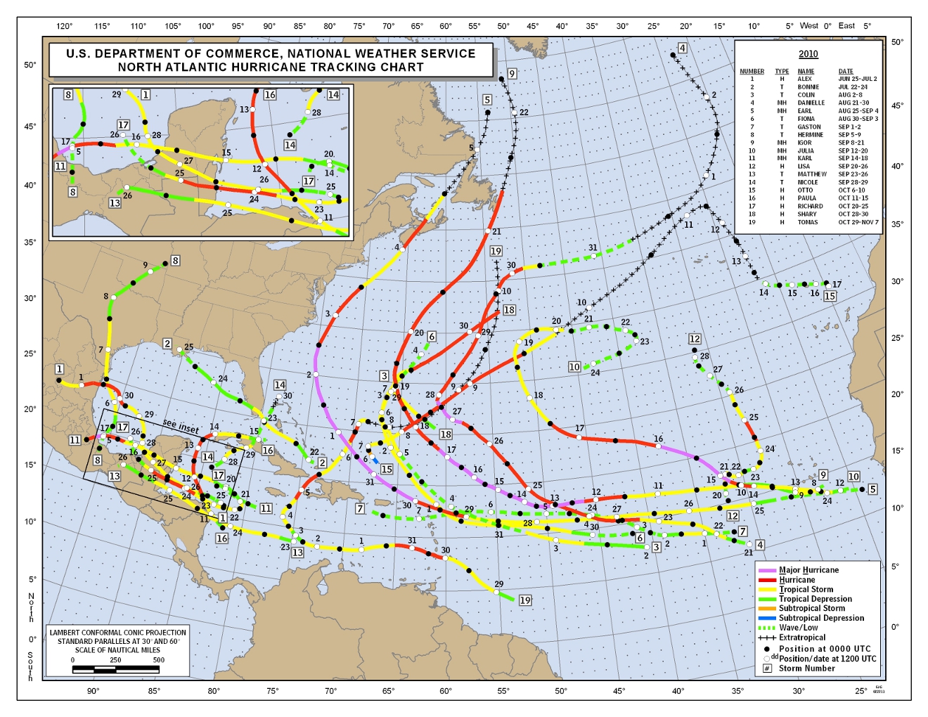
As it turned out, 2010 produced a very active season that was unusual in the lack of U.S. landfalls given the number of storms.  There were 19 named storms, 12 hurricanes, and 5 major hurricances (Category 3 or higher). Amazingly, with 12 hurricanes, there were no U.S. hurricance landfalls and only one Tropical Storm - Bonnie, which grazed south FL and fell apart as soon as it hit southeast LA. Another storm, T.S. Hermine, made landfall just south of the U.S.-Mexico border, technically in Mexico.  Though the U.S. was spared, there were two landfalling hurricanes in Canada - Earl in southeast Nova Scotia and Igor, near St. John's, Newfoundland.  Both reached Major Hurricane status over the Gulf Stream.

Tracks of all named 2010 Atlantic tropical systems (click for larger image)
The number of storms in 2010 was pretty close to (actually slightly over) predictions from Dr.'s Klotzbach and Gray from Colorado State University and Dr. Joe Bastardi, then of Accuweather.  However, both expected multiple U.S. landfalls, as would be expected in this type of active year.  The number of storms was also in the range provided at this time last year by NOAA.

So, onto this year!  NOAA indicates that the climate factors that will affect this year's Atlantic hurricane season include the fact that we are in a continuing high activity era, which has been ongoing since 1995 and is multi-decadal, warm sea surface temperatures about 2° F above the long-term average in favored storm development regions (a phenomena referred to as the Atlantic Multidecadal Oscillation, or AMO), and, though La Nina is dissipating, it's impacts such as reduced wind shear over the Atlantic will continue into the hurricane season.  Wind shear is a hurricane killer - less wind shear allows storms to develop and maintain strength. Tropical Atlantic forecasts issued for 2011 are listed below.

NOAA
Named storms: 12-18
Hurricanes: 6-10
Major hurricanes: 3-6

Colorado State University
Named storms: 16
Hurricanes: 9
Major hurricanes: 5
72% chance of a U.S. landfall

Accuweather
Named storms: 15

Hurricanes: 8
Major hurricanes: 3

Last year, I closed my hurricane forecast blog with this statement, and it is appropriate again this year:

"As hurricane season begins, it is wise for those that could potentially be in the path of one of these storms to make all necessary preparations and pay close attention to forecasts and watches/warnings as they are issued by the National Hurricane Center. For those living in the Mid-South, MemphisWeather.net's tropical page will have the latest storm tracks and bulletins. Be mindful that, while the threat is not nearly as great here [in the Mid-South], remnants of tropical systems can bring widespread flooding rains, tropical storm force wind, and/or severe weather to this region of the country."

Stay tuned... Hurricane season begins on Wednesday!

----
Stay up to date on the latest weather conditions and forecast by checking out MemphisWeather.net on Facebook and Twitter and our new iPhone and Android apps!

Thursday, May 12, 2011

Pork-cast: what to expect weather-wise for this weekend's Memphis in May barbecue contest

Memphis in May's annual World Championship Barbecue Cooking Contest is this weekend and the smell of pork and "everything else" will be wafting across the Fairgrounds very soon thanks to Mississippi River flooding causing a change of venue to newly-completed Tiger Lane.  I love the Memphis in May marketing teams BBQ contest poster this year - check it out to the left.

While the recent heavy rains here and to our north have forced a location change, unfortunately that doesn't guarantee a dry event! The MWN Forecast has all the details, but it looks like BBQ teams will be dealing with a few scattered thunderstorms this afternoon (hopefully not over the Fairgrounds, because these could have some heavy rain associated with them). Then, after midnight, a round of showers and thunderstorms will move into the area, perhaps lasting until Friday morning.

For Friday, a cold front inches closer to the region with thunderstorms re-developing during the afternoon and lasting into the evening. The Mid-South is under a Slight Risk for severe storms during this time period, so a few storms could pulse with hail or a brief high wind gust. Most will remain below severe limits, but will produce some areas of heavy rain and lightning. If you plan to be at the BBQ Contest Friday afternoon/evening, bring an umbrella and plan to take cover if skies turn threatening.  One great way to stay on top of the latest weather information is via the MWN iPhone and Android apps - links are provided at the bottom of this post.

Post-front, we'll be under the influence of an upper level low throughout the weekend.  This will result in much cooler temperatures, mostly cloudy skies, and low chances of showers Saturday and Sunday, with highs only in the 60s!

Monday will transition from cloudy/cool to a little more sun.  Then, the middle of next week looks fabulous with springtime temperatures in the 70s and abundant sunshine!

----
Stay up to date on the latest weather conditions and forecast by checking out MemphisWeather.net on Facebook and Twitter and our new iPhone and Android apps!

Thursday, October 21, 2010

MWN 2010-2011 Winter Outlook

2009-2010 Winter Outlook
It was about this time last year that I issued my MWN Winter Outlook for 2009-2010, in the midst of a mild El Nino winter. At that time, I expected the winter to be drier than average and temperatures slightly above normal. I went one for two. According to climate statistics from Memphis International Airport for December 2009 through March 2010, temperatures and precipitation were below average in each of those months. (In fact, February temps averaged a whopping 7.5 degrees below normal.) In addition, I expected at least one "couple inch" snow event. That is exactly what happened, when a 5"+ snowfall occurred on February 8, 2010 (much more fell not too far north of the airport), in addition to an inch-and-a-half event in January.

Global patterns
For the upcoming winter, the global setup is opposite of last winter. A fairly strong La Nina event is in progress, which means cooler than average sea surface temperatures (SST) in the eastern equatorial Pacific. The bottom image below shows the Pacific SST anomalies as of early-October - note the below normal SSTs in the eastern Pacific.

What does a wintertime La Nina typically mean for the eastern U.S.? The map below shows what to expect in general terms, courtesy of NOAA. The dark blue lines are the average positions of the jet streams. From this map, the Mid-South could expect above normal temperatures, wet conditions, and a potentially active pattern due to the jet stream being positioned overhead. This combination could mean the potential for strong to severe weather at times.

Indeed, NOAA's Climate Prediction Center long-range forecasts for this winter indicate above normal temperatures and precipitation for the December-February time period - or a warm and wet winter. The last La Nina winter was 2007-2008, which you may recall produced the Super Tuesday tornado outbreak on February 5, 2008. Earlier today, NOAA issued their official winter outlook which nearly mirrors the conditions that would be expected under a La Nina, as it will be the most dominant feature impacting North American weather this winter. The images below show the temperature and precipitation outlooks from NOAA (click for larger images).


MWN's Outlook
Given the La Nina conditions in place and the confidence that this scenario will continue throughout the winter months, I believe we could see an end to the drought conditions by mid-winter (if not before) as above normal precipitation will be likely. In addition, the possibility of a mid-winter severe weather event would appear to be slightly higher than normal given the average jet stream position over the region. This jet position would favor storm systems of Pacific origin moving across the region fairly often, resulting in above normal precipitation. Increased clouds and precipitation would result in above normal low temperatures, while the position of the Arctic jet stream well to the north would mean above normal temperatures as well. Thus, temperatures will average above normal.
Farmer's Almanacs side-note: Both the Farmer's Almanac and Old Farmer's Almanac are forecasting cold conditions and average to below average precipitation. With all due respect to both, I disagree.

----
Get the latest weather conditions and much more by checking out MemphisWeather.net on Facebook and Twitter!

Thursday, May 13, 2010

Still watching weather for the Barbecue Cooking Contest

Very little has changed with regards to the expected weather pattern for the Memphis in May World Championship Barbecue Cooking Contest which kicks off today and continues through Saturday. You can view my previous forecast post here.

A cold front will move into the region tonight, pushing slowly through metro area during the day Friday and stalling out over north MS on Friday night and Saturday. The presence of the front, along with abundant moisture and instability, will cause scattered showers and thunderstorms to develop beginning late tonight and lasting through Friday. Most activity is expected to die off Friday evening, though more scattered precipitation will be around on Saturday. The severe weather threat is marginal as most of the necessary dynamics will be east of the region, from middle TN into the mid-Atlantic. However, an isolated strong storm could produce a brief high wind gust or small hail, especially during peak heating hours on Friday and Saturday afternoons.

For a complete look at the forecast, please visit the MWN Forecast at MemphisWeather.net. In addition, if you are hanging out downtown this weekend and need a quick check of radar or the forecast, check out MWN Mobile on your web-enabled handheld device (http://pda.memphisweather.net) for the latest conditions, forecast information, and the best web-based radar in Memphis - StormView Mobile Radar.

You can also follow @memphisweather1 on Twitter or MWN on Facebook (http://www.facebook.com/memphisweather1) for more frequent updates.

----
Get the latest weather conditions and much more by checking out MemphisWeather.net on Facebook and Twitter!

Sunday, April 4, 2010

MWN forecast accuracy for March 2010

March is typically a difficult month to forecast as large temperature and moisture swings are possible over a short time period and a miscalculation in the timing of a frontal passage by just a few hours can introduce significant error in temperature and dewpoint forecasts. MWN managed to keep these significant errors to a minimum in March and by the smallest of margins bested the computer model forecasts with respect to high and low temperature forecasts for the month.

For the month, the average temperature error in all MWN forecasts was 1.71 degrees, or 0.01 degrees better than the Global Forecast System (GFS) model, taking first in the temperature category. For dewpoint accuracy, the MWN forecast was also the best of the data sources at 2.81 degrees average error, again beating the GFS by only 0.03 degrees.

More detailed accuracy statistics can be found here.

----
Get the latest weather conditions and much more by checking out MemphisWeather.net on Facebook and Twitter!

Saturday, September 26, 2009

Fall weather on the way

The rainy pattern of the past 2 weeks has finally shifted east today. Weak high pressure takes over this weekend before another cold front moves through Monday. However, this front will be dry. Thus, the MWN forecast reflects dry and warm weather this weekend, followed by cooler and much less humid weather behind the front for much of next week. In fact, dewpoint temperatures - a measure of humidity in the air - will be their lowest since spring. These low dewpoints will allow overnight temperatures to drop as well, with some locations in outlying areas near 50 by Tuesday and Wednesday mornings! We'll be watching for another front late in the week that could bring our next chance of rain.

Interesting fact of the day: Though there was much more accumulating rain the week before last than this past week (at least in the metro area), the manual rain gauge co-located with the WXLIVE! rain gauge recorded 13 straight days of measurable precipitation. That string will come to an end today, and it's about time! To learn more about the CoCoRaHS program, a network of volunteer precipitation observers, click here.

In the tropics, Tropical Depression #8 formed in the Atlantic a couple of days ago, but as of 3pm has deterioriated into an open wave, meaning it no longer has a closed circulation and cannot be classified as a depression.

----
Become a fan of MemphisWeather.net on Facebook and follow MWN on Twitter!

Monday, August 24, 2009

Is it still August?

What a fabulous weather weekend across the Mid-South! Canadian high pressure dominated just as predicted and brought the region a re-lapse of our near-record cool July! Highs topped in the lower 80s at best over the weekend while many places outside the city proper dropped into the 50s in the early morning hours. Can't ask for much better! In fact, my friends in Jackson, TN saw a record low Sunday morning (54) and a record cool max Sunday afternoon (78). My station in Bartlett dropped to 58 Sunday morning and 57 this morning.

As for humidity levels, they were basically non-existent compared to a "normal" August day in the Bluff City. Normally, surface dewpoints (a measure of the actual water content in the air) average in the 65-70 degree range this time of year. The official dewpoint at Memphis International has been at or below 60 (mostly in the 50s) since just after midnight Saturday morning - a streak of 63 hours and counting. I expect that streak to come to an end during the day tomorrow, but 3 days of very low humidity is certainly something we'll take.

As we head into the meat of the work week, temperatures will moderate some as that high pressure moves east and more southerly wind emerges, bringing dewpoints and humidity levels back up slightly over the next couple of days and temps will return to the upper 80s to near 90. There will be some rain chances late in the week and early this weekend, though it appears that starting next week we may get another one of those great big Canadian highs to bring us another shot of atypical weather to close out the month! Let's all cross our fingers for that! All the details can be found in the MWN Forecast.

In the tropics, Bill has become extratropical and is headed across the northern Atlantic towards, of all places, the British Isles. Forecasters are now watching what could become "Danny" in the western Atlantic. Check the MWN Tropical Page for the latest on this developing storm. Forecast models indicate it could strengthen into a storm later this week and become a threat to the U.S. East Coast over the weekend.

----
Become a fan of MemphisWeather.net on Facebook and follow MWN on Twitter!

Monday, July 20, 2009

Dry weather comes to an end Tuesday

Dry weather will end on Tuesday as an unusually strong low pressure system for this time of year moves just north of the area, dragging a cold front through the Mid-South. The clouds and precipitation will keep temperatures in check - near 80 for highs. Dry weather returns for the rest of the work week.

----
Become a fan of MemphisWeather.net on Facebook and follow MWN on Twitter!

Tuesday, July 14, 2009

Survey says 300B weather forecasts used annually

A recent survey by the National Center for Atmospheric Research (NCAR) reports that U.S. adults obtain an estimated 300 BILLION (300,000,000,000) forecasts each year! The survey, conducted in 2006, also says that nearly 9 out of 10 adults obtain a weather forecast regularly, with the average being more than 3 forecasts a day. The study, the first of its kind, was funded by the National Science Foundation and NOAA, the organization that the National Weather Service falls under. The study also found that most people place a high confidence in forecasts out to 1-2 days and that they are "generally satisfied" with the forecasts obtained. At MemphisWeather.net, we hope that our very intelligent and savvy users are more than just "generally" satisfied - that they are "thrilled" with the products and services provided!

For the official press release on the survey with more details on the findings, click here (PDF).

----
Become a fan of MemphisWeather.net on Facebook and follow MWN on Twitter!

Friday, July 3, 2009

Independence Day forecast

For those planning to go to fireworks shows and other outoor events tonight or Saturday, weather is looking pretty decent, considering it is early July. It will be very warm (hot to some) and humidity will definitely be higher Saturday than tonight, but I think most rain will hold off until after Saturday evening's events. Rain chances will increase overnight Saturday night and scattered thunderstorms will be around on Sunday as a cold front lingers over the region before moving out early next week. Right now, I would not cancel any outdoor plans, but it might be a good idea to have a "Plan B" for Sunday, just in case Mother Nature decides that Mid-Southerners are parched enough and she relieves some of the dryness with some much-needed rain. For most areas, we're now into our third week of rain-free conditions and the heat of the past few weeks is taking its toll on vegetation - and we don't need golden brown lawns this early in the summer! A complete look at the forecast for Memphis and the Mid-South can be found at MemphisWeather.net.

----
Become a fan of MemphisWeather.net on Facebook and follow us on Twitter!

Monday, June 29, 2009

Humidity heads south with cold frontal passage

What a difference 24 hours makes! Temperatures this morning are anywhere from 10-15 degrees cooler than yesterday at this time. WXLIVE! is currently sitting at 64 degrees - yesterday is was 79. In fact, a record maximum low temperature was set once again yesterday with a low of 81 degrees at midnight last evening (it dropped to 82 yesterday morning, but the low recorded is a 24-hour low).

This cooldown is thanks to a frontal system that moved through yesterday. If you were outside during the late afternoon or evening, you could probably start to feel the difference as a fresh north breeze was blowing and humidity was dropping. Though it was still hot, the official temperature got to only 94 - breaking a string of 11 straight days of 95+ weather.

For the next couple of days, I expect we will continue to see low humidity levels, though temperatures will remain in the 90s (lower half, not upper!). Morning lows will fall into the 60s for most Mid-Southerners through mid-week.

The Independence Day forecast is now posted at MemphisWeather.net - I'll have more detail on the blog in a couple of days on what to expect with your fireworks forecast.

----
Become a fan of MemphisWeather.net on Facebook and follow MWN on Twitter!

Saturday, June 27, 2009

Heat continues for two more days

Memphis International Airport tied another record low temperature this morning - the maximum low for the day. Provided a stray thunderstorm doesn't cool it off before midnight tonight, we will tie the record of 81 set in 1978. Given the extreme heat and abundance of humidity, the National Weather Service has pulled the Excessive Heat Warning out of the bag of tricks for the second time this week. High temps will top out in the upper 90s to near 100 today with the humidity making it feel like 105-110 this afternoon. Stay indoors if possible, or make sure you are taking plenty of precautions if you must be in the heat.


The heat- and humidity-breaking cold front we have been waiting for for almost two weeks now arrives tomorrow (see the map above valid at 7pm Sunday)! With only a small chance of thunderstorms, the high for Sunday will still be near 97, so Heat Advisories will likely still be in effect. However, behind the front much drier air infiltrates the Mid-South and "cooler" temperatures (actually, just closer to normal) move in too. For the start of the work week, high temperatures will be near 90 to the lower 90s with negligible humidity. The best part will be the mornings when lows will drop into the 60s!! it will continue to be dry throughout most of next week with moderating humidity levels. No extreme heat is in the extended forecast though after this weekend!

----
Become a fan of MemphisWeather.net on Facebook and follow MWN on Twitter!

Wednesday, June 10, 2009

Summertime pattern shapes up over the Mid-South

It's been a while since I posted my own thoughts, so it's probably time. I use this blog to not only write about my opinions on weather and other topics, but pass along information that I think may interest my readers. Lately, I've been in "passing along" mode, so today it's a forecast discussion.

However, I first want to send out a thank you to all of you who check The MWN Blog regularly, or who just happen to drop in searching for a certain topic. In the past 2 weeks or so, we touched a couple of milestones. The blog's visitor count since July 2008, when visitor tracking was added, hit 13,000 on June 3rd. In addition, the page view count went over 20,000 on May 28. I know there are plenty of you who also read this through means other than just on the blog site (the only place visitors are tracked), such as Facebook, Blogged, by e-mail subscription, etc. Thank you for relying on the writings here to keep you informed and maybe even mildly entertained. ;-)

On to more important topics, like the weather! Summertime has definitely arrived, even though the calendar says it's still 11 days away. The signs of summer are building upper level high pressure, south wind pushing very warm humid air into the region, stalled fronts sparking scattered showers and thunderstorms, and the occasional Ozone Advisory! We've had all of these in the past week. The summertime forecast, which can occasionally be fairly mundane, is anything but that when a frontal boundary approaches as we have now. You never know exactly where or when the next cluster of storms is going to appear! I generally don't like blanketing "chance of rain" forecasts out for days on end, but unfortunately that generally ends up being accurate at the end of a summer day. Some folks will get very wet (like Tipton County this morning) and some won't get a drop!

A frontal system will move into the area tomorrow, providing an increased chance of t'storms, some of which could pulse above severe limits with hail or damaging wind gusts, especially during peak heating hours. The front will hang out for a couple of days before retreating back to the north as high pressure re-builds over the region this weekend. Until then, we can expect the daily thunderstorm chance, highs in the upper 80s to near 90, and dewpoints that make for uncomfortably humid conditions. By early next week, the upper-level high really starts to assert itself and we're looking at the potential for the hottest days of the year yet (mid 90s are possible) with a fair amount of humidity still hanging on. In fact, we could see the first mentions of heat indices over 100 degrees. Memphis summer is definitely back!