Sunday, November 6, 2022

Mild weather for Election and Veterans Days, then the bottom falls out...

A strong frontal system that produced tornado damage in the Southern Plains Friday night brought a couple of thunderstorms, but mostly much needed (and well-timed) overnight rainfall Friday night to the Mid-South. With clearing by the afternoon, Saturday turned out decent with temps in the 60s, leading to a chillier (but not abnormal) morning with lows today in the 40s. Today has been gorgeous with highs in the 70s and sunshine. The motto for the coming week's weather is going to be "enjoy it while you got it!" A major early winter cold front promises to bring MUCH colder air next weekend!

Sunday night-Monday

As a warm front lifts north, remnants of what was leftover from yesterday's front, and another cold front approaches in the coming 24 hours, clouds increase this evening with showers not far behind. We're expecting scattered showers after midnight with rain likely over the area for the morning rush hour. Showers should diminish as we head toward the lunch hour, and be mostly gone before we hit that unwelcome 5pm sunset! Temperatures will generally remain mild with 60s throughout the night tonight and lower 70s for highs on Monday.

A loop of the surface weather map from Sunday evening through Tuesday evening shows a front in the vicinity with some showers tonight and Monday. The western U.S. will be where the wild weather resides! (Weather Prediction Center)

Election Day through Thursday

With no major fronts in the area and winds starting to switch back toward the south, more mild weather is expected for elections on Tuesday and right through the mid-week. Clouds should break apart Tuesday as well with a light northeast breeze, so expect highs back in the mid 70s after another mild morning low. These conditions continue Wednesday and Thursday with highs generally in the mid 70s and lows near 60 Wednesday morning and mid 50s Thursday morning. 


Veteran's Day and beyond

The next major cold front arrives on Friday. But with not a lot of moisture to work with, rain chances are fairly low (and we may remain dry altogether), though clouds will accompany the front. Temperatures remain mild in the morning - mid 50s for lows - but only recover to the mid 60s by early as northwest wind becomes gustier, signaling the front's arrival. 

A strong cold front will be poised to move through the Memphis area by Friday morning, bringing the coldest air of the season next weekend. Note also the red "L" over northern FL where a tropical system is forecast. (Weather Prediction Center)

For next weekend, the sunshine will be great, but the temperatures not so much! More winter-like temperatures will encompass a large portion of the country. For Memphis, we're thinking lows will be near freezing with highs barely reaching 50 degrees, if that, both Saturday and Sunday! Below normal temperatures also look to continue right into the following week.

Forecast high and low temperatures from the NWS Blend of Models shows a tale of two seasons in the coming ten days! (WeatherModels.com)


The temperature outlook for mid-November shows most of the country in the grips of below-average temperatures. For Memphis, "normal" during this period is lower 60s for highs and lower 40s for lows. (Climate Prediction Center) 

An eye on the tropics

One other interesting weather note this week - it appears that Florida will be dealing with a tropical system, perhaps a hurricane, by the middle of the week! The National Hurricane Center expects this development to occur as a low approaches the Bahamas from the east on Tuesday, then likely moves over the Florida peninsula Wednesday/Thursday before recurving up the east coast. Tropical weather season doesn't end until November 30, so while late for a tropical system in Florida, it's not unheard of!

Tropical development appears likely in the northern Caribbean early this week with models taking a tropical storm or possibly a hurricane into Florida around mid-week. A "fish storm" in the central Atlantic will pose no threat to land. (National Hurricane Center)

Erik Proseus
MWN Meteorologist

----
Follow MWN on Facebook and Twitter for routine updates and the latest info!
Complete MWN Forecast: MemphisWeather.net on the mobile web or via the MWN mobile app
Download our iPhone or Android apps, featuring StormWatch+ severe weather alerts!
MWN is a NOAA Weather Ready Nation Ambassador Meteorologist Erik Proseus is an NWA Digital Seal Holder

Sunday, October 16, 2022

A quick-hitting cold spell this week brings the first freezing temperatures of the fall

With a few short-lived exceptions of a couple days here and there in the mid 80s, fall has settled in nicely this month after a - let's all admit it - brutal summer. Low dewpoints in general have meant very pleasant (even a few chilly) mornings this month, comfortable daytime conditions even when we do crack 80 degrees, and patio-worthy evenings. The average temperature so far this month of 66 degrees is 1.7 degrees below average.

And while we admit the drought is definitely a problem for those depend on periodic soaking rains, for those of us who don't really want to worry about adjusting plans for raindrops, the lack of it has meant an abundance of opportunities to enjoy the fall we have had so far.

Cold weather lies just around the corner

This weekend we've finally had a few rounds of rainfall, despite some lightning and hail stones thrown in as well. So while the weekend timing is not ideal, it's been helpful to those who really needed it. Turning our eyes to the forecast ahead though makes those of us who do this for a living head to our reference material for an important fall statistics - the "first frost" and "first freeze" data. Yes, it's going to get THAT cold this week. Time to dig deep for the windshield scraper you buried early in the spring if you aren't "from around here." Or if you are, you'll just open the purse or wallet and pull out the least-used credit card from the bunch - because it also doubles AS your ice scraper! 


Surface high pressure plowing south from the Great Plains via the Canadian Express, coupled with a deep upper level trough of cold air setting up over the eastern U.S., will mean our first blast of "early winter" air this week. Fortunately, it'll ding-dong-ditch us rather than moving in like your mother-in-law, and we'll warm up again by the end of the week before that credit card scraper is too heavily damaged. 

The upper level pattern, around 18,000 feet up, will feature massive high pressure in the western U.S. and a very cold trough of low pressure in the eastern U.S. on Tuesday evening. That pattern will draw Canadian air south. (WeatherBell)/Euro model


So just how cold will it get? 

The biggest tip-off is that a Freeze Warning is in effect for Tuesday morning for pretty much everywhere north of the latitude of the TN/MS state line, while a Freeze Watch is in effect for the remainder of the Mid-South, including Memphis. In Shelby County, the retained urban heat may be able to fend off the freezing line a bit longer. (As an aside: most watches and warnings that aren't for severe storms are issued by county or zone. I don't believe ALL of Shelby County will escape freezing temperatures, so if you are well outside the big city and typically run a bit cooler than the official observations from the airport, you might as well be under a Freeze Warning too.) 

A Freeze Warning is in effect for Tuesday morning for all of the light blue counties (including Tipton and Fayette Counties) and a Freeze Watch for the southern half of the Mid-South, including Memphis and Shelby County. Blue is used because it is the color your lips and fingertips might be if you are out in it for long and not appropriately attired!

For the record, the earliest Fall Freeze in Memphis (at the airport) is October 16 (today). This won't be record-breaking. But the average is November 12. And the average first frost (using 36 degrees as a proxy) is November 3. So we will be roughly 2 weeks early on that front. For cooler areas outside the city, those "first" dates are earlier. 

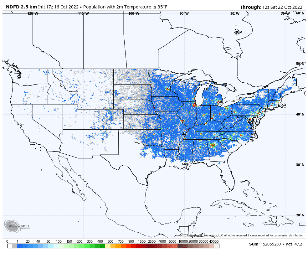
Roughly 47% of the U.S. population, or over 150 million people, will be at or below 35 degrees sometime this week according to NWS forecasts. Frost will be possible nearly to the Gulf Coast! (WeatherBell)

Also, Tuesday morning won't be the coldest morning this week. Wednesday morning will be a few degrees cooler. So that Freeze Warning may drop a bit further south Wednesday morning, and MAYBE Shelby County will be included as well, though the urban core may not quite get to 32 frosty degrees. Both Tuesday and Wednesday will see high temperatures in the 50s, despite full sunshine. That's roughly 20 degrees below normal, which will result in unpacking the sweaters and hoodies and stirring up some hot chocolate for a few days! We highly recommend covering or bringing indoors any flora or fauna that might wilt or die if exposed to frost or a freeze on Monday, Tuesday and Wednesday nights. These temperatures are not cold enough to require extreme measures like dripping faucets, but you might also make sure Fido's water bowl (and Fido himself) are in good shape too!

Cold gives way to a warming pattern

The pattern starts to shift by Thursday. After yet another frost-filled morning in the 30s, high temperatures will rebound into the 60s and true southerners will shed layers and be back to shorts and crocs. Another couple of chilly mornings are likely to end the week and start next weekend, but at least afternoon temperatures will be back to near normal by Friday (mid 70s) then above normal going into next weekend (upper 70s to near 80). Precipitation chances appear to be nil for most of the next week. The complete forecast details can be found in the MWN app or here on our MWN mobile website.

By Saturday morning, the upper level pattern shown above is forecast to break down, with "zonal" flow (or west- to-east) for much of the nation, which favors near average conditions and no major storm systems. (WeatherBell / Euro model)

Erik Proseus
MWN Meteorologist

----
Follow MWN on Facebook and Twitter for routine updates and the latest info!
Complete MWN Forecast: MemphisWeather.net on the mobile web or via the MWN mobile app
Download our iPhone or Android apps, featuring StormWatch+ severe weather alerts!
Support our efforts via our virtual tip jar on Patreon!
 
MWN is a NOAA Weather Ready Nation Ambassador Meteorologist Erik Proseus is an NWA Digital Seal Holder