Sunday, March 27, 2022

More spring-like weather: warmer, then stormy, then cooler again

The springtime weather roller-coaster continues on as we head out of a dry but cool weekend and towards the end of March and beginning of April. While March came in like a lamb, it may be going out like a lion, as the potential for severe storms exists on Wednesday. Let's take it day by day.

Monday - Still cool

The Mid-South remains in a "northwest flow" regime to start the week with wind aloft from the northwest, keeping temperatures from rising much of any above normal and bringing periodic high cloud cover. However, with high pressure shifting to the east of us, we should see temperatures warmer than Sunday on an easterly wind. Looks for highs in the mid 60s, perhaps some upper 60s with just enough sunshine. After a cool start near 40 degrees in the morning, Monday night's conditions will be much milder with wind shifting to the southeast, keeping temps in the 50s overnight.

Tuesday - Warmer and breezy

Tuesday is really a setup day for Wednesday. Though likely to remain dry, a storm system moving out of the southwestern U.S. into the southern Plains will bring much more cloud cover and southerly wind will become gusty (to 25 mph) as humidity rises to more typical levels for this time of year. Look for highs to respond to the south wind and reach the mid to upper 70s. Can't rule out a stray shower, but it's unlikely. South wind will remain fairly strong Tuesday night as the southern Plains system approaches and the low level jet stream increases, and that will keep it warm overnight with temperatures remaining in the 60s.

Wednesday - Weather Alert Day!

All eyes are on Wednesday this week as it is likely to be an active weather day across the lower to mid Mississippi Valley, potentially including the Mid-South. Very strong south wind will continue to feed moisture into the region as a cold front moves in from the west. Look for wind gusts throughout the day to reach 35-45 mph, perhaps even touching 50 mph! The Trash Can Meter indicates your waste receptacle will be over yonder and may even roll down in the holler!


As of Sunday afternoon, it appears the ETA for stormy weather will be in the afternoon hours, most likely from around school dismissal time through rush hour, though that could easily still change by a couple of hours. 

The model comparison above shows forecast precipitation between 1pm and 7pm Wednesday between the European model (left) and American GFS model (right). There is strong agreement between the models on timing Wednesday afternoon. Drilling down a bit closer, we expect mid to late afternoon to be prime storm hours. (WeatherBell)

The Storm Prediction Center has been highlighting a potential severe weather outbreak for 3 days now, and as of today, indicates that is most likely to occur just to our south, though severe storms are entirely possible in the Mid-South as well. 


The severe weather outlook issued Sunday for March 30 indicates that severe storms appear likely across portions of AL, most of MS and western AL. Severe weather is possible however as far north as the the Mississippi/Ohio River confluence and across all of eastern AR. (NWS/SPC)

While this is still 72 hours or so out, the most likely scenario appears to be a squall line with high wind over 60 mph, though it is possible that a few rogue storms could form ahead of the line. With wind screaming from the surface up, and plenty of shear, tornadoes are a distinct possibility as well.  They would be most likely in rogue cells that form, but also possibly embedded within a squall line. Areas just to our south are the most favored, but this scenario definitely bears watching. 

The main limiting factor right now appears to be storm fuel, or instability. If we get some morning sunshine and temperatures approach 80 degrees ahead of the system, that higher risk zone could expand further north. Updates on our severe weather threat, as well as wall-to-wall coverage on Wednesday, will be provided on our social media feeds linked below.

The arrival of the cold front by early evening will bring an end to this round of severe weather and usher in cooler air Wednesday night on gusty west wind. as temperatures fall back into the 40s by Thursday morning.

Thursday/Friday - much calmer

It looks like seasonally cool and dry weather is on tap to end the week and start the month of April - no foolin'. Morning lows in the 40s and afternoon highs in the mid 60s with a cool breeze on Thursday in particular. 


Next weekend and beyond - Overall cool

Computer models are not in good agreement on next weekend at this point, but hint at a possible system moving by to our south, which could throw some showers over us Saturday and maybe Sunday. It will remain cool with temperatures similar to the end of the week - highs in the mid 60s.  Overall, the start of April is forecast to be cooler than average (which is near 70 for highs and near 50 for lows). No additional major storm systems are on the horizon out to about 10 days after Wednesday.

Cooler than average temperatures are favored for the Mid-South to start April with precipitation generally near average. (NWS/CPC)

Erik Proseus
MWN Meteorologist

----
Follow MWN on Facebook and Twitter for routine updates!
Download our iPhone or Android apps, featuring StormWatch+ severe weather alerts!
MWN is a NOAA Weather Ready Nation Ambassador Meteorologist Erik Proseus is an NWA Digital Seal Holder

Saturday, March 19, 2022

Spring officially arrives! Tuesday is this week's "weather aware" day

Equinox vs. Equilux: a primer

We've experienced #FakeSpring (maybe a couple times), "Fool's Spring," "Spring of Deception," and even meteorological spring over the past month or so. But as of 10:33am Sunday, REAL spring arrives! Astronomical spring, a.k.a. the vernal equinox, marks the time when the sun passes directly over the equator heading north, resulting in longer days and more direct sunlight in the northern hemisphere. 

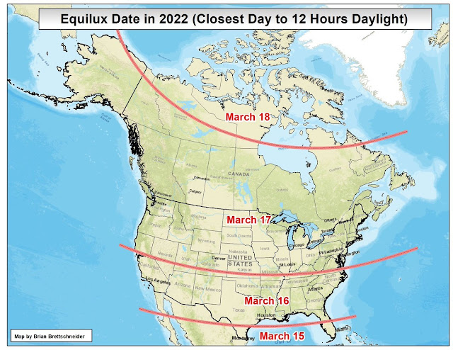
But did you know that the equinox is NOT when daylight/darkness is equal over the course of a day? The equilux, the actual day when the sun is above the horizon for the closest to 12 hours, varies by latitude. In Memphis, that actually happened this past Wednesday, when the sun was above the horizon for 11 hours, 59 minutes, and 51 seconds. The sun set Wednesday night at 6:08pm and rose Thursday morning at 6:08am!

The equilux is now behind us, with increasing daylight each day, while the equinox occurs Sunday morning. 

This weekend: beautiful spring weather

So now that we have equinox and equilux straightened out, today is officially the last day of winter and we're starting with conditions that feel like it - grey sky, chilly breeze, temperatures in the 40s. But that will change pretty quickly as Mother Nature takes a look at her astronomical calendar and realizes there is some catching up to do! Sunshine breaks out by mid-day with temperatures responding to the March sun and warming to 63°, just shy of the average high for today. For the first day of spring, we can't ask for much better - sunshine, a cool but about average morning low in the low 40s, and high temperatures that warm to 73° with a light southwest wind. I think we'll take it!

Early week spring storm

Monday will continue the above average temperatures with highs in the lower 70s, but signs of a spring-like storm system will be brewing - from the high clouds streaming overhead to the increase in southeasterly breezes. As that storm system brews over the southern Plains, our initial rain chances arrive Monday night with mild temperatures in the mid 50s.

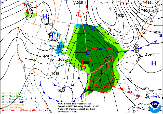
The NWS surface weather map valid Tuesday morning. A pair of cold fronts are to our west, while southerly wind ahead of the low pressure center brings rain and scattered thunderstorms to the Mid-South. (NWS/WPC)

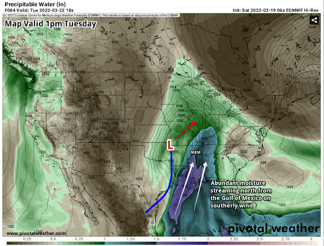
Tuesday is the one day this week that we need to be "weather aware." As low pressure moves northeast from the southern Plains towards the Mid-Mississippi River Valley, a surge of moisture on strong south wind will overspread the Lower Mississippi Valley and Deep South. That is shown below by "precipitable water" values, which measure total atmospheric moisture. Values near 1.5" (very high for this time of year) will reach as far north as the metro, indicating plenty of water in the air to rain out.

The overnight European model valid mid-day Tuesday shows low pressure moving by to our northwest, a cold front draped through east TX moving east, and abundant moisture (color shading) surging north from the Gulf of Mexico. Values just shy of 1.50" in Memphis area near the 99th percentile climatologically, or about the maximum we would typically observe in mid-March. (Pivotal Weather, annotated by Erik Proseus)

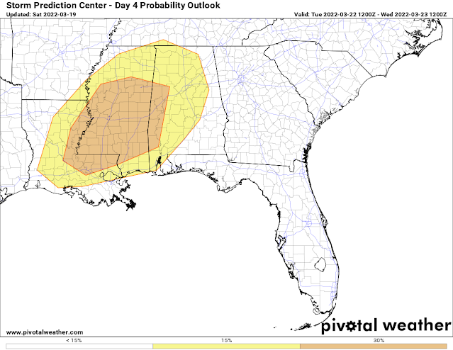
We'll also see instability increase modestly on those strong southerly winds. Though the most favorable concentration of moisture, instability, and wind shear for the production of strong to severe storms will be to our south in MS and AL, we're likely to see a line of storms as well, though perhaps not quite with the "oomph" of those to our south. We'll still need to be watching for the possibility of scattered damaging wind gusts though, especially with the cold front in the afternoon hours.

The NWS Storm Prediction Center highlights areas just to our south for the likelihood of severe storms on Tuesday. For our area, thunderstorms are expected, but won't be as intense. (NWS/SPC)

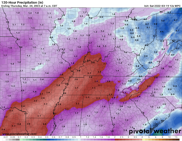
Rainfall totals through Thursday morning, as projected by the NWS, show a swath of 2-4" across the Mid-South. Most falls on Tuesday. (NWS/WPC)

Overall, our main threat Tuesday is going to be very heavy rain during the daytime that could result in minor to perhaps moderate flooding of low-lying and drainage areas, as well as smaller streams and creeks. Rainfall totals from this system (Monday night through Tuesday night) will likely range from 2-4" with locally higher amounts. In addition, a few storms could produce strong wind gusts, in addition to dangerous lightning. I expect we will be in a level 1 (Marginal) risk of severe weather on Tuesday and would not be surprised if at least our north MS counties were in a Slight Risk, or level 2.

Mid-week: cool with more clouds than sun

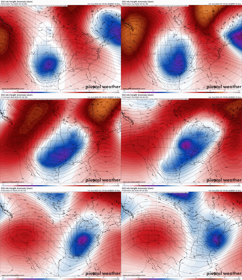
Behind the system Tuesday, a trough of upper level low pressure will linger for a couple of days, with an upper level low pressure center moving nearby on Thursday. This pattern favors cooler than average temperatures, more clouds than sunshine, and possibly a few light rain showers. Look for highs in the upper 50s to lower 60s these days with lows in the mid 40s Thursday morning. Not the beautiful spring weather we'd like, but spring is not all sunshine and unicorns as we know! It's a transition season.

The pressure pattern from Monday evening through Friday evening at 500mb (about 18,000') from the European model shows the presence of abnormally low pressure (blues to purple) affecting our area through the end of the week. This will result in lingering clouds and cooler than average temperatures.

Next weekend: sunshine returns!

By the end of the week, upper level high pressure builds back over the area with moderating temperatures and sunshine to end the week and through next weekend. High temperatures will be back into the 60s to near 70, though cool mornings linger. Hey, if you have to pick your days for sunshine, might as well be the weekend!


Erik Proseus
MWN Meteorologist

----
Follow MWN on Facebook and Twitter for routine updates and the latest info!
Complete MWN Forecast: MemphisWeather.net on the mobile web or via the MWN mobile app
Download our iPhone or Android apps, featuring StormWatch+ severe weather alerts!
MWN is a NOAA Weather Ready Nation Ambassador Meteorologist Erik Proseus is an NWA Digital Seal Holder