Monday
Unfortunately, a cold front brought another round of rainfall overnight into this morning, adding another three-quarters of an inch to an inch of rain to the overflowing gauge. As of noon, that front has now pushed just south of I-40 as it moves south and stalls over MS and AL. It'll remain there for a little more than a day, which means cooler air behind it sinks into the metro and remains locked in place with temperatures mainly in the 40s after reaching 60 degrees at noon today. It's proximity, along with upper level energy aloft, will keep skies cloudy with another round of light rainfall overnight Monday night.Tuesday
Tuesday will feature another cloudy day with overnight rain moving out early in the day and a brief dry lull for most of the morning and early afternoon as temperatures continue to linger in the 40s. However, by afternoon, additional light rainfall will ride the southwest jet stream up and over the area, so for the most part plan on another cool and damp day Tuesday with light rain continuing into the overnight.Wednesday
By Wednesday morning, rain intensity will pick up a bit as the front to our south lifts back towards us and low pressure develops along it to our southwest, heading towards north MS and the Tennessee River Valley. Wednesday appears to be wet all-around as that low passes just to our east. Some rain could be heavy and thunder is also possible depending on how close the low gets to the metro. Models are still bickering on its exact track.Severe weather to our south
The good news is, as long as the low stays east of the Mississippi River as it moves northeast (which it should), we won't be in the path of any severe storms. Those across MS and parts of AL may not be as lucky with severe weather a distinct possibility on Wednesday.Rainfall and flooding potential
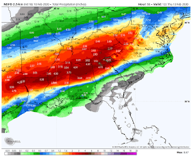
By Wednesday night, the low moves away, dragging the front all the way through the region and mercifully bringing an end to the rainy pattern for a bit. Rainfall totals from last night through Wednesday night however will likely be above 3" and may approach 4" in spots. Again, fortunately, the axis of heaviest rain, where 6" or more is possible, is not too far to our south. Flooding (flash and river/stream) is likely on those areas, though we'll also see streams rise and some low-lying and urban flooding possible due to saturated ground. |
| The Excessive Rainfall Outlook through early Tuesday morning indicates a high risk of flooding rain to our southeast. (NWS) |
Valentine's weekend
The end of the week features much cooler temperatures Thursday through Saturday with highs in the 40s and lows Friday and Saturday mornings in the mid to upper 20s! You might be able to stoke up the fireplace or fire pit for Valentine's Day with temps that chilly, but bundle up if you head out to your favorite romantic restaurant! |
| The forecast map for Valentine's morning features a massive area of cold high pressure dominating the eastern 2/3 of the country. (NWS/WPC) |
Erik Proseus
MWN Meteorologist
----
Follow MWN on Facebook and Twitter for routine updates and the latest info!
Complete MWN Forecast: MemphisWeather.net on the mobile web or via the MWN mobile app
Download our iPhone or Android apps, featuring StormWatch+ severe weather alerts!
 |  |
| MWN is a NOAA Weather Ready Nation Ambassador | Meteorologist Erik Proseus is an NWA Digital Seal Holder |


No comments:
Post a Comment