
Happy Groundhog Day... here we go again!
Another very challenging forecast for winter weather, this time dealing with ice instead of snow or a mix. Will handle this blog as a bit of a Q & A. The overall scenario has been laid out already and I assume most are familiar, but a quick refresher to start...
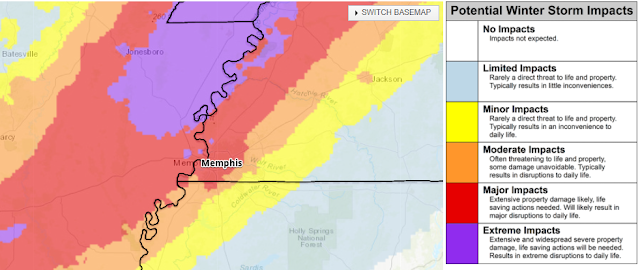
 |
| Actual warning map as of noon Wednesday (NWS) |
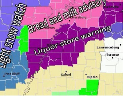 |
| Not the actual warning map |
Overview
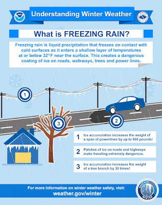
An Arctic cold front arrives late this afternoon and temperatures immediately start to drop. Scattered rain showers will continue off and on through the afternoon and into tonight. By early morning (pre-dawn), the main round of precipitation moves into the metro from the southwest as the freezing line closes in on us from the northwest. All precipitation will fall as rain Thursday, but if the temperature at your location is 32 or lower, it is called "freezing rain" and will begin to glaze exposed objects and surfaces. By late afternoon, temperatures across the entire metro will be at or below freezing as precipitation tapers. It will continue in a "patchy" fashion into the overnight hours however, likely as freezing drizzle, light sleet, or perhaps some snow flurries as temperatures drop into the mid 20s.
Q & A
1. When will the temperature drop to freezing at (my location)?
This is the biggest question, and one that the most recent "good" short-term models are not helping answer. The correct answer is it will drop to freezing at your location after your neighbors to the northwest drop to freezing. Despite starting the early morning rain at 34-35°, the freezing line may take its time crossing the metro as low pressure moves by to our east and the front stalls.
I expect Crittenden County and other places across the river to start freezing just before dawn. Those east and southeast of Shelby County may stay above freezing until the middle of the day. The best guess right now for the immediate metro is "sometime during the morning hours" and earlier in Downtown than East Memphis, but it may bounce around a bit between 31-33° for multiple hours before finally dropping for good around mid-afternoon.
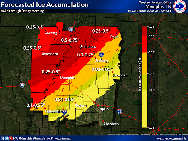
2. How much ice are we talking about?
While total precipitation (in liquid form) during the day Thursday is likely to exceed one inch, perhaps close to two in spots, there are two factors at play: a) when your location reaches freezing and b) how heavy the rain is coming down. The first is obvious - earlier transition means more accumulation. The second maybe not quite so obvious - heavy rain is actually partially a deterrent to significant accumulation because moving water doesn't freeze well, especially at temperatures of 30-32°. If it is all running into the gutters, it won't freeze. In general, forecasts calling for 1/4-1/2" of ice accretion (accumulation) are probably about right. It could be a little heavier across the bridge in AR, and places east of Memphis could see less due to later transition.
3. How will the roads be? How about flights?
Really good questions, and not ones that I have good answers for. Main roads should be fine, especially in the morning, but with prolonged cold, they could become a little dicey as the day goes on. Clearly exposed bridges and overpasses/flyovers - anything with "air" beneath it, could freeze much quicker. Secondary streets may also present some issues as the day goes on. Road treatment will likely have to be reactive, as the rain ahead of this system will wash away any pre-treatment. If you must travel, be extra cautious and avoid overpasses if you can.
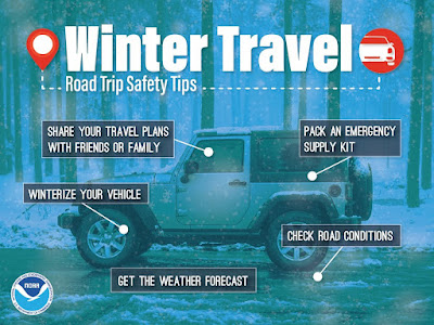
The airport is well-equipped to handle winter weather, but ice is still pretty hard to treat and remove. The more likely scenario is the airport remains open but flights are proactively cancelled by the airlines to avoid getting planes and flight crews caught and out of position for their next trips. You might have better luck in the morning than later in the day. As always, check with your airline and expect delays at a minimum.
4. Will there be power outages and downed trees?
Most likely, yes. Couple exposed wires with gusting wind and some lines may snap. Given the forecast, I don't expect it to be widespread, but some will lose power. And given the conditions during and after the event, and the possible damage to the lines themselves, it may take some time to restore those who lose power. Tree branches falling on lines and damaging bulkheads at homes is also another possibility. Large, older trees and those still carrying leaves are most susceptible. Even if your lines are buried, somewhere along the transmission path, there's likely an overhead line. Prepare for the possibility of power outages by keeping your devices (and backup batteries) charged, your refrigerator and freezer doors closed to preserve the cold air, and, if you have one, testing out that generator.
5. What are the main challenges with this forecast?
Simple - the timing of the freezing air. A difference of a few hours means a lot more/less precipitation that would fall in a given location. I'll also add, how the ground responds to steady rain and falling temperatures, which directly correlates to road conditions.
6. What does a busted forecast look like?
The freezing line is delayed by several hours and very little ice accumulates. That's a busted forecast in a positive way! We hope for that of course. If cold air arrives quickly and sweeps all the way through the metro, a "boom" forecast could result in significant icing, including on main roads and widespread power outages. This seems more unlikely than getting less icing than forecast.

7. Do the bluffs or Pyramid play a role?

8. I hate winter. How fast will it all go away?
Good question. The precipitation will end overnight Thursday night. Clouds depart Friday afternoon and temperatures should make it just above freezing then. However, Friday morning wind chills in the lower teens won't feel great and could be even worse if you are trying to pull yourself up off the steps you slipped down on the way out.
Melting should commence some on Friday afternoon, but anything liquid will freeze back over Friday night as we drop into the upper teens. Sunshine and upper 30s is expected Saturday afternoon which will help melt any lingering ice even more.
Prepare now!
Everyone should finish up preparation today, including for the potential for power outages that could last a few days, downed tree limbs if you have big trees or those that keep their leaves over the winter, and alternate plans for any activities you have planned for Thursday and Friday. Remember to take care of those pets and people in your life, and stay safe!
MWN Meteorologist
----
Follow MWN on Facebook and Twitter for routine updates and the latest info!
Complete MWN Forecast: MemphisWeather.net on the mobile web or via the MWN mobile app
Download our iPhone or Android apps, featuring StormWatch+ severe weather alerts!
 | |
| MWN is a NOAA Weather Ready Nation Ambassador | Meteorologist Erik Proseus is an NWA Digital Seal Holder |
No comments:
Post a Comment