
Recap of Ice Storm 2022
Wow, what a storm! Unfortunately, the forecasts leading up to Thursday's ice storm proved to be fairly accurate. Nearly 2" of liquid fell from the sky and much of that occurred with temperatures at or below 32 degrees, making it "freezing rain." Forecast details included that much of it would run off and not freeze due to the intensity of the precipitation, and that streets in general would not be too bad due to temperatures staying very close to freezing. The forecast also predicted 0.25-0.50" of ice on exposed objects such as trees and power lines. All of that proved to be accurate and most sources seemed to be in unison on the forecast and potential impacts.
It's cold and a mess but I'm trying to appreciate how pretty it is. #tnwx #icestorm #memwxr @memphisweather1 @3onyourside @Weather_WREG3 pic.twitter.com/BQrd4Pm0zN
— Steve Crain (@stevecrain901) February 4, 2022
Those impacts, though, were far-reaching: tree branches falling, trees uprooted, power lines thickly coated, slick overpasses and bridges, and power outages to hundreds of thousands of utility customers. Memphis Light Gas and Water (MLGW) reported that 272,000 customers were affected at one point or another, which is nearly 2/3 of their customer base.
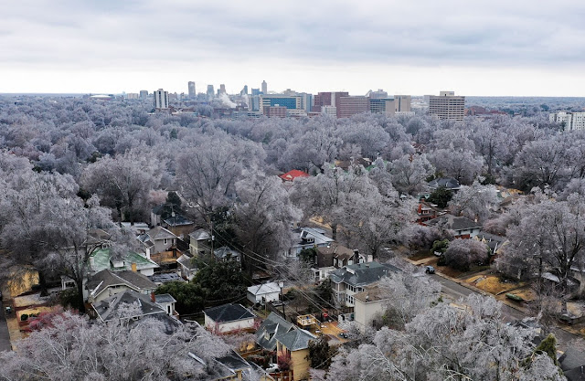 |
| The Medical District and Downtown Memphis skyline surrounded by ice-covered trees following an ice storm on February 3, 2022. Photo used with permission. (Patrick Lantrip/Daily Memphian) |
As of Sunday afternoon, that number is down to about 80,000, or 20% of their customers in Shelby County. The hope is to have another 10% (or about 40,000 more) restored by midnight Monday night and everyone restored by the end of the week. There are currently 1,000 MLGW or contract lineman and tree trimmers working on restoration. This storm now ranks as the second worst in the utility's history, behind "Hurricane Elvis" in 2003 (340,000 customers out) and ahead of the benchmark for ice storms in the area: the infamous 1994 storm, in which about 250,000 customers lost power. In that storm, it took two weeks to fully restore the city.
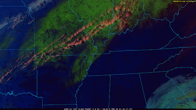 |
| Late Sunday afternoon satellite imagery using the "Day Cloud Phase" product shows lingering snow and sleet in bright green. Notice there is none over the Memphis area and most of west TN, as glaze ice like we received doesn't show up on this channel. and most had also melted. (College of DuPage) |
Click here for a gallery of photos from The Daily Memphian, or check out our Twitter feed for photos!
Turning our sights to the future though, I hand the keyboard over to MWN intern Dylan Hudler...
This week's forecast
Phew! After the ice storm, we need a break from active weather. Well, we’re in luck because that’s exactly what Mother Nature has in store for us.
This coming week will feature fairly calm weather thanks to high pressure. We’ll experience three frontal passages - all "dry," meaning they won’t bring any rain or storms. That’s about all the "action" we’ll see in the near term.

Monday may start off foggy for some of us, especially from Memphis into the Mississippi Delta. Ice melt today has left a lot of moisture in the region. Calm winds and a couple of other factors may lead to some patchy fog tomorrow morning. Otherwise, we’ll warm to near 46 in the afternoon under partly cloudy skies.
Tuesday looks to be warmer and breezier as winds shift out of the southwest. Winds may gust 15-20 mph.
Wednesday and Thursday both will feature sunshine and afternoon high temperatures in the mid 50s.
Friday will be even warmer, with a high near 60! Southwest winds will help to bring warm air and moisture into the region ahead of an approaching front. It’s possible we see some isolated light showers Friday evening associated with that front, but there’s uncertainty with it being five days away. For now, we’ll keep rain chances at 10%.
Next weekend brings a mix of sun and clouds, with highs likely in the 40s and lows near 30.
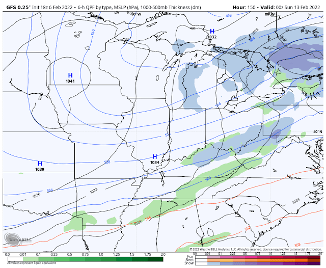 |
| The American GFS model valid on Saturday night shows low precipitation chances to our south associated with a frontal passage earlier in the day locally. Another large, cold high pressure system centered over the Midwest brings us cooler weather for the weekend. (WeatherBell) |
Looking ahead to the week of the 14th, the NOAA Climate Prediction Center expects near normal temperatures and perhaps slightly above average precipitation according to the outlooks shown below.
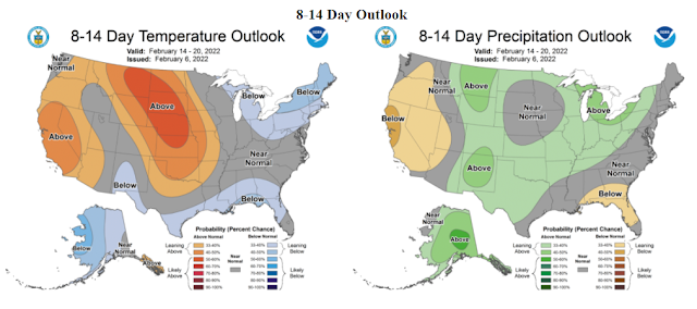 |
| NOAA CPC temperature and precipitation outlook for February 14-20. |
Parting thoughts
Lastly, as some of you may know, I have accepted a job offer from WCBI-TV in Columbus, MS to be their newest meteorologist. This will be my last time logging on for MWN. I am excited to start my new job, but sad to leave my family here at MWN. I would like to say thank you to Erik and the rest of my MWN team because without them, I wouldn’t be where I am today. I am so thankful for my time forecasting and covering the weather for this amazing community. I’ve loved every minute of it! So, with that being said, this is MemphisWeather.net Intern Dylan Hudler “/DH” signing off. Thank you all!
Intern swap
[Back to Erik... ]
Dylan has been an awesome addition to #TeamMWN and I am so grateful for his service to us and all of you! He has an amazing future ahead of him and I look forward to one day seeing him on the green screen in a large market in his home state of North Carolina.
Dylan is being replaced by another bright young man with a ton of potential. Jacob Woods hails from the Mayfield, KY area (yes, the Mayfield that was hit hard by a tornado on December 10) and will be on "the MWN tweeter" in about a week! I look forward to his unique perspective having recently been through a major event.
We wish you nothing but the best in your future endeavors, Dylan!
MWN Meteorologist / MWN Social Media Intern
----
Follow MWN on Facebook and Twitter for routine updates and the latest info!
Complete MWN Forecast: MemphisWeather.net on the mobile web or via the MWN mobile app
Download our iPhone or Android apps, featuring StormWatch+ severe weather alerts!
 | |
| MWN is a NOAA Weather Ready Nation Ambassador | Meteorologist Erik Proseus is an NWA Digital Seal Holder |
No comments:
Post a Comment