
Analysis
Now, based on the latest model guidance, there is a chance you'll be waking up to some some actual accumulated snow Saturday morning.
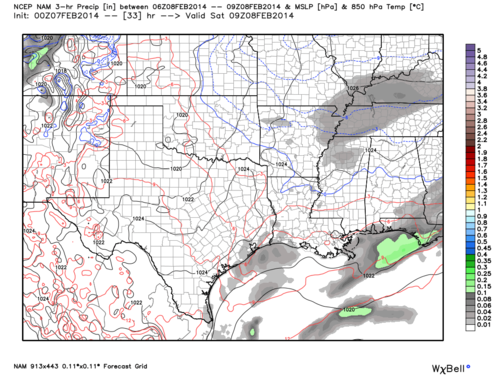 |
| NAM 3-hourly precipitation totals valid from midnight to 3AM on Saturday |
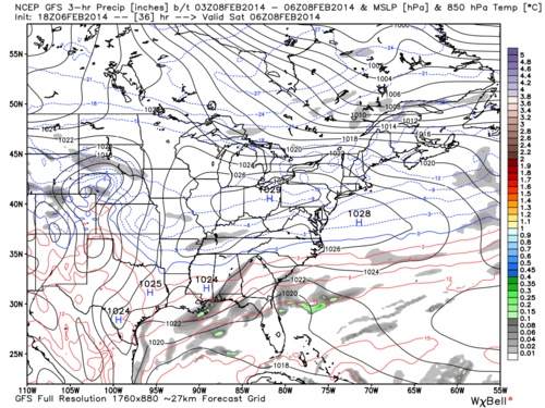 |
| GFS 3-hourly precipitation totals valid from 9PM to midnight on Friday |
So you can probably see the problem we're facing. Models are undecided on where the snow will be even a short period away from the event. This is not uncommon. Liquid equivalent amounts (snow melt) are extremely light overall, and no one would care about this blog if we were discussing whether light rain would fall Friday night.
What we do know at this point is that temperatures should NOT be a problem this time around! What we're dealing with here is a lack of moisture, plain and simple. Most of any snow that occurs Friday night will face its demise in the lower levels of the atmosphere, sublimating before it can gently reach the ground. If uplift can overpower the dry layer of air for a short period of time, those lucky flakes will become our very light accumulations Saturday morning before melting during the day.
Forecast
At this point I would put the odds of very light accumulations at about 50/50. As far as totals are concerned, a dusting is the most likely, with perhaps a half inch of snow as the highest amount (less likely than getting nothing at all). Therefore we do not expect much impact on the roads if you have plans on Saturday, especially since temps are expected to get above freezing and melt just about all of it.
Teaser
An early look at the beginning of next week suggests the potential for larger accumulations. Since this is several days out, we cannot speak on exact totals but can say that the set-up favors additional moisture but at the cost of borderline temperatures. We will have another blog detailing this next system this weekend.
In the meantime you can check out the full MWN Forecast here and follow us on Facebook and Twitter for the latest updates.
-William Churchill, MWN Social Media Intern
----
Follow MWN on Facebook, Twitter, and Google+
Visit MemphisWeather.net on the web or m.memphisweather.net on your mobile phone.
Download our iPhone or Android apps, featuring StormWatch+ severe weather alerts!
No comments:
Post a Comment