As winter finally begins to back off we see ourselves getting into a weather pattern that presents the threat of severe weather. This is not a huge surprise, because the polar jet stream has the tendency to hang around our area through late winter. Any warm-up that occurs is likely to be a brief and could be followed by severe weather due to the highly active pattern that winter brings along with it. For this reason you should be prepared for severe weather in EVERY season. (Note: this week is also
Severe Weather Awareness Week, [SWAW] so the timing is rather coincident.) Although winter is not typically thought of as severe weather season, the beginning and end of winter certainly bring the potential. Let's take a closer look at Thursday's setup,.
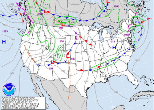 |
| The Weather Prediction Center's Short Term Forecast for Wednesday Evening |
The Weather Prediction Center short-term forecast shows a developing low-pressure system in eastern Colorado by Wednesday evening. This is our area of interest as the surface low and associated upper-level trough progress east. The system will tap into plenty of Gulf moisture as southerly winds at the surface advect plenty of warmer air quite a ways northward.
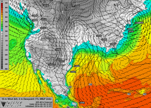 |
| GFS 2-meter Dewpoints and 10-meter Wind Speed/Direction valid Thursday Morning |
By Thursday morning there will be a good amount of moisture to work with at the surface which is a key ingredient for thunderstorms and severe weather. Dew points look to already be in the 60's by morning, likely continuing to slowly increase until the arrival of the cold front.
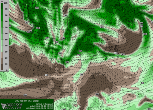 |
| GFS 700 mb (10,000') Relative Humidity valid Thursday Morning |
The primary reason precipitation could remain limited up until the arrival of the cold front and associated squall line is due to mid-level dry air. As you go up in the atmosphere, the wind begins to shift toward the west until it loses that moisture feed from the Gulf. Instead we get warm, drier air moving into the mid-levels which is actually stopping any deep convection from forming.
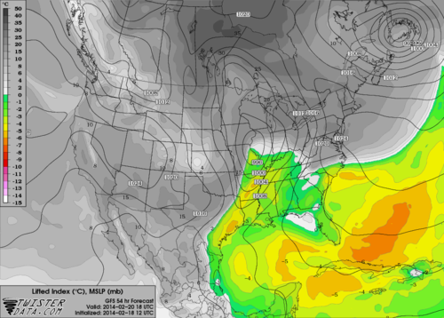 |
| GFS Lifted Index (an indicator of instability in the atmosphere) valid Thursday at noon |
However, it is only a matter of time before there is enough forcing due to the approaching front and associated upper-level dynamics to burst that cap on the atmosphere. When this occurs, there will be sufficient amount of unstable air present in the mid-levels of the atmosphere to make for some strong to severe thunderstorms. The above image shows the Lifted Index, which is just one variable that meteorologists look at to gauge severe storm POTENTIAL. This does not necessarily mean severe weather will occur, but this particular variable indicates that the atmosphere will be unstable by mid-day Thursday.
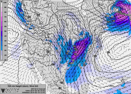 |
| GFS 925-mb Wind Speed/Direction valid Thursday at Noon |
Once storms along the cold front have fired, we will need to keep a close eye on any rapid increase in strength as very strong winds will be present just above the surface (about 2,000 feet). When any of these thunderstorms become intense their downdrafts can carry these 60 mph+ winds to the surface quite easily, and the result is a straight line wind threat we have previously mentioned.
One thing that is fairly uncertain at this time is where and when the line of storms will fire. This plays a big role in whether or not we experience severe weather in the Mid-South. If storms are able to get going, they will likely be forming in the early afternoon just to our west. Thus, the best opportunity for severe weather in the Memphis metro will likely be during the afternoon hours, when we are also at peak heating for the day (lower 70s temps) and instability is theoretically maximized.
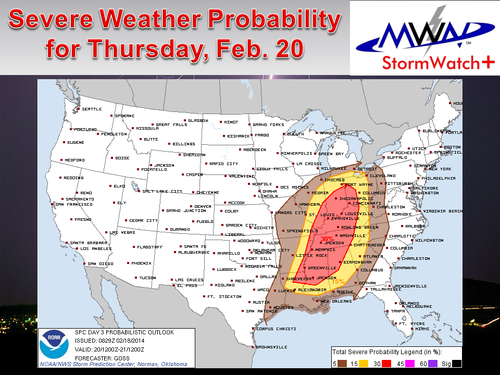 |
| The Storm Prediction Center Day 3 Probabilistic Outlook for Severe Weather |
The Storm Prediction Center has the Mid-South in a Slight Risk with a 30% probability of severe weather Thursday. Storm mode primarily favors a squall line event. While a weak embedded tornado cannot be ruled out, our primary concern will be damaging straight line winds. However, this does not mean you should not prepare. Straight line winds can pose significant problems, as many in the Mid-South already know.
Be sure to check out our
daily blogs this week that contain severe weather safety information. It's also a good time to activate StormWatch+ on your mobile phones, which you will find in the
MemphisWeather.net mobile app for Android and iPhone/iPad. For Severe Weather Awareness Week, the StormWatch+ upgrade (which basically puts a highly-precise weather radio in your pocket/purse) is 25% off! Download it, set it up for the locations you care about, and get some peace of mind when severe weather threatens!
Finally,
our SWAW webpage has a listing of the awesome giveaways MWN and our key partners are doing this week, including a ride along on a storm chase with
Mid-South Storm Chasers and a free underground storm shelter from
Take Cover Storm Shelters! Be sure to check it out, follow us on Facebook and Twitter for the latest updates, and tell your family and friends in the area where they can go for the only severe weather nowcasting service in the Mid-South!
-William Churchill, MWN Social Media Intern
-Erik Proseus, MWN Meteorologist
----
Follow MWN on
Facebook,
Twitter, and
Google+
Visit
MemphisWeather.net on the web or
m.memphisweather.net on your mobile phone.
Download our
iPhone or Android apps, featuring
StormWatch+ severe weather alerts!

No comments:
Post a Comment